Order Total (1 Item Items):
Shipping Destination:

Commercial Maps (3 results)
Skip to main search results
Search filters
Product Type
- All Product Types
- Books (3)
- Magazines & Periodicals (No further results match this refinement)
- Comics (No further results match this refinement)
- Sheet Music (No further results match this refinement)
- Art, Prints & Posters (No further results match this refinement)
- Photographs (No further results match this refinement)
- Maps (No further results match this refinement)
- Manuscripts & Paper Collectibles (No further results match this refinement)
Condition Learn more
- New (No further results match this refinement)
- As New, Fine or Near Fine (No further results match this refinement)
- Very Good or Good (1)
- Fair or Poor (No further results match this refinement)
- As Described (2)
Binding
- All Bindings
- Hardcover (1)
- Softcover (No further results match this refinement)
Collectible Attributes
- First Edition (No further results match this refinement)
- Signed (No further results match this refinement)
- Dust Jacket (No further results match this refinement)
- Seller-Supplied Images (2)
- Not Print on Demand (3)
Language (1)
Price
- Any Price
- Under US$ 25 (No further results match this refinement)
- US$ 25 to US$ 50 (No further results match this refinement)
- Over US$ 50
Free Shipping
- Free Shipping to U.S.A. (No further results match this refinement)
Seller Location
Seller Rating
-
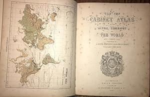
Cabinet Atlas of the Actual Geography of the World, With a Complete Index., 1867, Complete With 34 Coloured Maps
Published by W & A. K. Johnston, Edinburgh, 1867
US$ 207.42
US$ 28.19 shipping
Ships from United Kingdom to U.S.A.Quantity: 1 available
Add to basketHard Cover. With a Frontis Physical & Commercial Chart of the World Plus 33 Maps, All Coloured (illustrator). PP: Frontis Map, (v), (i)blank, 33 Maps, 35(index), (i)Advert. Original cloth with "Atlas" in gilt to upper cover. Foxing to the first few pages; otherwise very good. Size: 31.5 X 25.5 Cms.
-

Kent Map
Published by London . 1708., 1708
Seller: Little Stour Books PBFA Member, Canterbury, United Kingdom
Association Member: PBFA
Seller rating 5 out of 5 stars

US$ 89.88
US$ 40.28 shipping
Ships from United Kingdom to U.S.A.Quantity: 1 available
Add to basketUncoloured copper engraved map 8�'' x 7�'' inches. Commonly referred to as 'Miniature Morden's' this map was printed as part of 'Fifty Six New and Accurate Maps of Great Britain' published in conjunction with Herman Moll in 1708. Mounted on contemporary paper with a brown stain to the verso of the right hand margin of the mounting paper, (not the map), folded lines across the top and bottom margins of the map, records society label to the reverse of the map. Member of the P.B.F.A. KENT [Maps].
-

A Map of the Countries Between Constantinople and Calcutta, Including Turkey in Asia, Persia, Afghanistan, and Turkestan
Published by Edward Stanford
Seller: Books From California, Simi Valley, CA, U.S.A.
Seller rating 4 out of 5 stars

Condition: Good. This is a large folding coloured linen backed map. Map is clean with minimal wear. No copyright date is given.