Order Total (1 Item Items):
Shipping Destination:

Compiled Drawn (66 results)
Skip to main search results
Search filters
Product Type
- All Product Types
- Books (63)
- Magazines & Periodicals (No further results match this refinement)
- Comics (No further results match this refinement)
- Sheet Music (No further results match this refinement)
- Art, Prints & Posters (No further results match this refinement)
- Photographs (No further results match this refinement)
- Maps (3)
- Manuscripts & Paper Collectibles (No further results match this refinement)
Condition Learn more
- New (No further results match this refinement)
- As New, Fine or Near Fine (30)
- Very Good or Good (25)
- Fair or Poor (2)
- As Described (9)
Binding
Collectible Attributes
- First Edition (15)
- Signed (No further results match this refinement)
- Dust Jacket (3)
- Seller-Supplied Images (39)
- Not Print on Demand (66)
Language (2)
Free Shipping
Seller Location
Seller Rating
-
Guide to the archaic chinese script ( = Scandinavian Institute of Asian studies Monograph series, No. 11 )
Language: English
Published by Lund, Studentlitteratur, 1972, 1972
ISBN 10: 9144094116 ISBN 13: 9789144094113
Seller: Antiquariat Carl Wegner, Berlin, B, Germany
Association Member: GIAQ
Seller rating 5 out of 5 stars

First Edition
Softcover. 8°, Original booklet with 32 pages. Bookplate on the inside front cover (Walravens, see note). Good condition. -- Originalheft mit 32 Seiten. ExLibris im vorderen Innendeckel (Walravens, siehe Anmerkung). Sauberes, gutes Exemplar. From the collection of Sinologist Hartmut Walravens (born 1944), with his bookplate on the inside front cover. From 1987, he served as the Senior Library Director at the Berlin State Library, Prussian Cultural Heritage, where he was responsible, among other things, for the German Journal Database (ZDB). Until 2007, he taught as a private lecturer at the East Asian Seminar at the Free University of Berlin. His research interests included bibliography and mandarin jurisprudence. -- Aus dem Besitz des Sinologen Hartmut Walravens (geboren 1944), mit dessen ExLibris im vorderen Innendeckel. Ab 1987 war er als Leitender Bibliotheksdirektor an der Staatsbibliothek zu Berlin, Preußischer Kulturbesitz, unter anderem für die Zeitschriftendatenbank (ZDB) zuständig. Bis 2007 lehrte er als Privatdozent am Ostasiatischen Seminar der FU Berlin. Zu seinen Forschungsschwerpunkten gehörten Bibliographie und Mandjuristik -- Bitte Portokosten außerhalb EU erfragen! / Please ask for postage costs outside EU! / S ' il vous plait demander des frais de port en dehors de l ' UE! // Bitte beachten Sie auch unsere Fotos! / Please also note our photos! / Veuillez noter nos photos -- Ob Sonnenschein oder warmer Regen: mit einem interessanten Buch kommen Sie immer gut durch den Tag. -- Wir kaufen Ihre werthaltigen Bücher! K21520-435866.
-

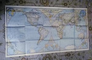
The World Map : The National Geographic Magazine
Language: English
Published by National Geographic Society, Washington D.C, 1951
Seller: J J Basset Books, bassettbooks, bookfarm.co.uk, Peter Tavy, United Kingdom
Seller rating 3 out of 5 stars

US$ 13.82
US$ 26.83 shipping
Ships from United Kingdom to U.S.A.Quantity: 1 available
Add to basketFold Out Map. Condition: Very Good. No Jacket. Compiled & Drawn in the Cartographic Section of the National Geographic Society (illustrator). First Edition. Please Email for further details. Size: 8vo - over 7¾" - 9¾" (Folded). Not Signed or Inscribed.
-
FLAGS AND STANDARDS OF THE NAPOLEONIC WARS
Language: English
Published by BIVOUAC BOOKS LTD, LONDON, 1976
First Edition
US$ 11.05
US$ 29.51 shipping
Ships from United Kingdom to U.S.A.Quantity: 1 available
Add to basketPaper Back. Condition: Near Fine. 1st Edition. In Alphabetical Order, from Austria - to - Wurzburg , Illustrated with text [Military War History]1976 1st printing. Please see our images of the actual book offered for sale for Further Details and condition. 112pp. 245x180mm. Profusely illustrated in + 8 Pages of Colour plates. Near Fine Laminated Paperback [ no insc; no annotation, sound binding, fine throughout. Covers- light edge shelf rubbing, No cover fade.
-
West Indies : The National Geographic Magazine
Language: English
Published by National Geographic Society, Washington D.C, 1954
Seller: J J Basset Books, bassettbooks, bookfarm.co.uk, Peter Tavy, United Kingdom
Seller rating 4 out of 5 stars

US$ 13.82
US$ 26.83 shipping
Ships from United Kingdom to U.S.A.Quantity: 1 available
Add to basketFold Out Map. Condition: Near Fine. No Jacket. Compiled & Drawn in the Cartographic Section of the National Geographic Society (illustrator). First Edition. Please Email for further details. Size: 8vo - over 7¾" - 9¾" (Folded). Not Signed or Inscribed.
-
Historical Atlas of Colonial North America From Prehistoric Times to 1823. Exploration, Conquest and Settlement. A Panorama of the Euro-American Period, From the Stone Age Mound Builders Through Colonial Times, Inclusive. Visualizes and Traces the routes Taken by Over 200 Explorers. Indicates Place-Names and Founding Dates of Several Hundred Cities. Outlines Colonial Political Divisions of Spain, Portugal, England and France. A Supplement for Histories and Geographies.
Published by Educational Research Bureau, Washington, D.C., 1942
Seller: Henry Hollander, Bookseller, Los Angeles, CA, U.S.A.
Seller rating 4 out of 5 stars
Softbound. Condition: Very Good. Octavo, stapled paper covers, 16 pp., two b/w maps, seven color maps including one two page color map at the center With three large fold-out charts with inset maps: Histo-Graph of Colonial North America, Histo-Graph of Ancient Empires, and Pan American Histo-graph.The Pan American Histo-Graph was done in cooperation with Curtis Wilgus.
-
Condition: Good. No Jacket. Hal Missingham (illustrator). 103pp, 7x10 inches, spine chipped.
-

Clarion Atlas. North American Edition (A Collins - Longmans Planned Atlas)
Language: English
Published by Longmans, Green & Co., Toronto & New York, 1950
Soft cover. Condition: Very Good. 65 pages. 22 cm. Card covers reinforced by blue cloth at spine. Maps on inside front and rear covers. Fully illustrated with over 50 pages of color maps of the world. Index to maps. A lightly rubbed wrappers; interior like new, fresh and unmarked.
-
Africa and the Arabian Peninsula : The National Geographic Magazine
Language: English
Published by National Geographic Society, Washington D.C, 1950
Seller: J J Basset Books, bassettbooks, bookfarm.co.uk, Peter Tavy, United Kingdom
Seller rating 3 out of 5 stars
US$ 19.35
US$ 26.83 shipping
Ships from United Kingdom to U.S.A.Quantity: 1 available
Add to basketFold Out Map. Condition: Near Fine. No Jacket. Compiled & Drawn in the Cartographic Section of the National Geographic Society (illustrator). First Edition. Please Email for further details. Size: 8vo - over 7¾" - 9¾" (Folded). Not Signed or Inscribed.
-
South America : The National Geographic Magazine Vol XCVIII No.4
Language: English
Published by National Geographic Society, Washington D.C, 1950
Seller: J J Basset Books, bassettbooks, bookfarm.co.uk, Peter Tavy, United Kingdom
Seller rating 3 out of 5 stars
US$ 19.35
US$ 26.83 shipping
Ships from United Kingdom to U.S.A.Quantity: 1 available
Add to basketFold Out Map. Condition: Near Fine. No Jacket. Compiled & Drawn in the Cartographic Section of the National Geographic Society (illustrator). First Edition. Please Email for further details. Size: 8vo - over 7¾" - 9¾" (Folded). Not Signed or Inscribed.
-
Atlantic Ocean : The National Geographic Magazine
Language: English
Published by National Geographic Society, Washington D.C, 1955
Seller: J J Basset Books, bassettbooks, bookfarm.co.uk, Peter Tavy, United Kingdom
Seller rating 4 out of 5 stars
US$ 19.35
US$ 26.83 shipping
Ships from United Kingdom to U.S.A.Quantity: 1 available
Add to basketFold Out Map. Condition: Very Good. No Jacket. Compiled & Drawn in the Cartographic Section of the National Geographic Society (illustrator). First Edition. Please Email for further details. Size: 8vo - over 7¾" - 9¾" (Folded). Not Signed or Inscribed.
-
The Far East : The National Geographic Magazine
Language: English
Published by National Geographic Society, Washington D.C, 1952
Seller: J J Basset Books, bassettbooks, bookfarm.co.uk, Peter Tavy, United Kingdom
Seller rating 4 out of 5 stars
US$ 19.35
US$ 26.83 shipping
Ships from United Kingdom to U.S.A.Quantity: 1 available
Add to basketFold Out Map. Condition: Near Fine. No Jacket. Compiled & Drawn in the Cartographic Section of the National Geographic Society (illustrator). First Edition. Please Email for further details. Size: 8vo - over 7¾" - 9¾" (Folded). Not Signed or Inscribed.
-
Northern Europe : The National Geographic Magazine
Language: English
Published by National Geographic Society, Washington D.C, 1954
Seller: J J Basset Books, bassettbooks, bookfarm.co.uk, Peter Tavy, United Kingdom
Seller rating 4 out of 5 stars
US$ 19.35
US$ 26.83 shipping
Ships from United Kingdom to U.S.A.Quantity: 1 available
Add to basketFold Out Map. Condition: Very Good Closed Tears. No Jacket. Compiled & Drawn in the Cartographic Section of the National Geographic Society (illustrator). First Edition. Please Email for further details. Size: 8vo - over 7¾" - 9¾" (Folded). Not Signed or Inscribed.
-
North America : The National Geographic Magazine Vol C1 No. 3
Language: English
Published by National Geographic Society, Washington D.C, 1952
Seller: J J Basset Books, bassettbooks, bookfarm.co.uk, Peter Tavy, United Kingdom
Seller rating 4 out of 5 stars
US$ 19.35
US$ 26.83 shipping
Ships from United Kingdom to U.S.A.Quantity: 1 available
Add to basketFold Out Map. Condition: Near Fine. No Jacket. Compiled & Drawn in the Cartographic Section of the National Geographic Society (illustrator). First Edition. Please Email for further details. Size: 8vo - over 7¾" - 9¾" (Folded). Not Signed or Inscribed.
-
Central Europe Including the Balkan States : The National Geographic Magazine
Language: English
Published by National Geographic Society, Washington D.C, 1951
Seller: J J Basset Books, bassettbooks, bookfarm.co.uk, Peter Tavy, United Kingdom
Seller rating 4 out of 5 stars
US$ 19.35
US$ 26.83 shipping
Ships from United Kingdom to U.S.A.Quantity: 1 available
Add to basketFold Out Map. Condition: Near Fine. No Jacket. Compiled & Drawn in the Cartographic Section of the National Geographic Society (illustrator). First Edition. Please Email for further details. Size: 8vo - over 7¾" - 9¾" (Folded). Not Signed or Inscribed.
-
Mexico and Central America : The National Geographic Magazine Vol CIII No. 3
Language: English
Published by National Geographic Society, Washington D.C, 1953
Seller: J J Basset Books, bassettbooks, bookfarm.co.uk, Peter Tavy, United Kingdom
Seller rating 4 out of 5 stars
US$ 19.35
US$ 26.83 shipping
Ships from United Kingdom to U.S.A.Quantity: 1 available
Add to basketFold Out Map. Condition: Near Fine. No Jacket. Compiled & Drawn in the Cartographic Section of the National Geographic Society (illustrator). First Edition. Please Email for further details. Size: 8vo - over 7¾" - 9¾" (Folded). Not Signed or Inscribed.
-
US$ 13.82
US$ 43.15 shipping
Ships from United Kingdom to U.S.A.Quantity: 1 available
Add to basketSoft cover. Condition: Good. Fifth edition. Flexible card cover with blue cloth spine. 187 x 222 x 6mm. 64pp. Attractive brightly-coloured maps throughout; with index. Cover lightly soiled, with cloth of spine a little worn; previous owner name and address in biro to title-page; internal contents clean and unmarked. NB: An extra shipping charge may be requested for heavier or more valuable items. All our 'Seller Images' show the actual item you will receive.
-
Lullabies of Many Lands
Published by New York. H.M. Caldwell Co. 1908, 1908
Seller: J. Patrick McGahern Books Inc. (ABAC), Ottawa, ON, Canada
Seller rating 4 out of 5 stars
20.5cm, 30p., frontis, 13 full page drawings by author, 13 music pages with illustration at top of each, illustrated endpapers, decorated& illustrated paper over stiff card covers, worn at the edges, good to very good copy (igc) Thirteen international lullabies are represented with full piano scores including France, Italy, Germany, Sweden, Japan, Russia and Norway. Each music sheet has a corresponding full-page illustration of a mother in national dress rocking a baby.
-

Ludwig Bemelmans: A Bibliography
Language: English
Published by James H. Heineman, Inc., 1993
ISBN 10: 0870081403 ISBN 13: 9780870081408
First Edition
Hardcover. Condition: Near Fine. Dust Jacket Condition: Very Good. With 77 reverently drawn irrelevant drawings by Ludwig Bemelmans (illustrator). 1st Edition. A comprehensive bibliography of all known written works, editions, illustrations and ephemera in English and translations by Bemelmans. Research by Murray Pomerance, author and cinema critic. Appendices: Chronology & Index of Foreign Titles. Index. [viii], xvi, 390 pp.
-
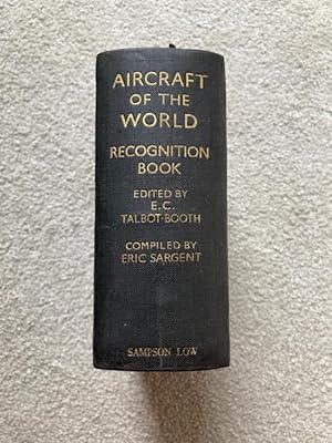
Aircraft of the World, A Recognition Book
Language: English
Published by Sampson Low, Marston & Co., Ltd., 1930
Seller: GN Books and Prints, Inverness, United Kingdom
Seller rating 5 out of 5 stars
US$ 35.22
US$ 25.76 shipping
Ships from United Kingdom to U.S.A.Quantity: 1 available
Add to basketHardback, cloth. Condition: As Described. No Jacket. Second Edition. Aircraft of the World, A Recognition Book, Edited by Paymr. Lieut-Comdr. E. C. Talbot-Booth, R.N.R. Drawn and Compiled by Eric Sargent. Hardback, second edition, undated but circa late 1930s-early 1940s (first edition published in 1937), illustrated, published by Sampson Low, Marston & Co., Ltd., London. Measures around 4 1/2" x 5 1/4" x 2 1/4". Pagination: (2) ix (1) 1094 (2) pp. Black cloth binding, faded gilt lettering to spine.Marking and scuffing to binding, some discolouration. Tearing to outer hinges, to head and tail of spine and to bumped corners. Creasing to spine. Slackness to binding. Page edges browned, scuffed and otherwise marked. Some marking to endpapers, gift inscription on front free endpaper. Some light foxing to page surfaces throughout and a little other marking nbut no underlining, marginalia, etc.See pictures for further information. 1094+ pp. Circa 1930s-40s. n.
-
LAKE NYASA, World Aeronautical Chart 3054. ICAO 1:1,000,000. Hypsometric tints for Africa. April 1959.
Language: English
Published by Printed by the Federal Government printer., Salisbury, Southern Rhodesia, 1954
Map First Edition
US$ 20.04
US$ 27.50 shipping
Ships from United Kingdom to U.S.A.Quantity: 1 available
Add to basketNo Binding. Condition: Good. First Edition. Sheet size 34 x 24 inches, 3 vertical and 1 horizontal fold. Key on verso. Used but no deliberate marks. See pics.
-
Railway Wagons of New Zealand Part I Specific Purpose Freight Wagons
Published by P.M. Forster, New Zealand
Soft Copy. Condition: VG+. Dust Jacket Condition: None. No date, presumed First Edition. Yellow cover, black titles, faint couple of smudges, phone number on front. Edges: just a couple of tiny foxing. Clean content. Staple binding is VG albeit staples are rusty. No page numbers,
-
Hardcover. Condition: Fine+. Dust Jacket Condition: No Dust Jacket. Illustrated by E. C. Talbot-Booth (illustrator). First Edition; First Printing. Blue boards sharp and square, normal shelf wear to edges. In Fine + condition. Book is firm in binding, b&w illustrations throughout. 1-1/2 inches thickness. Free of any markings, not ex-library. ; B&W Illustrations; 16mo 6" - 7" tall.
-
MAP of the CANADIAN PACIFIC RAILWAY. Between MANITOBA and LAKE NIPISSING (1874), from the ATLAS OF THE DOMINION OF CANADA (1875)
Language: English
Publication Date: 1875
Pas de couverture. Condition: Bon. Montréal, Toronto and London, George N, Tackabury, 1875, large two-pages map, about 26 X 18 inches, printed on both sides, in B&W. Complete and in good condition showing only a light general tanning to paper and to small tears to edges (right and left) (see images).
-
Pas de couverture. Condition: Bon. Montréal, Toronto and London, George N, Tackabury, 1875, large one-page map, about 18 X 13 inches, printed on both sides, with color. Complete and in good condition showing only a light general tanning and a few small chips and tears mainly to left edge (see images). My map is detached from an incomplete atlas and have therefore never been exposed to light, so the colours are quite fresh. A part of the mounted paper is still present.
-
PLAN OF OTTAWA (Carleton County) together with a MAP OF LANARK, LEEDS, GREENVILLE and CARLETON (Ontario) from the ATLAS OF THE DOMINION OF CANADA (1875)
Language: English
Publication Date: 1875
Pas de couverture. Condition: Bon. Montréal, Toronto and London, George N, Tackabury, 1875, large one-page map, about 18 X 13 inches, printed on both sides, with color. Complete and in good condition showing only a light general tanning and a few small chips and tears mainly to left edge (see images). My map is detached from an incomplete atlas and have therefore never been exposed to light, so the colours are quite fresh.
-
Pas de couverture. Condition: Bon. Montréal, Toronto and London, George N, Tackabury, 1875, une carte double-page du Témiscouata avec au recto et verso les deux autres cartes, environ 67 X 45 cm pour la grande carte, 45 X 33 cm pour les cartes simples, illustrées en couleur. L'onglet de papier est encore partiellement présent. Ces cartes sont tirées de l'édition de 1875 de l'atlas mentionné dans le titre, ce sont des originaux et non des copies. L'ensemble est en bon état sans rien à signaler autre qu'un léger brunissement des marges surtout (voir les images). On doit noter aussi un déchirure droite de 6 cm au pli inférieur On ne peut évidemment pas séparer les trois cartes puisqu'elles sont imprimées recto-verso.
-
The Beverley Patent. 1736 including original grantees, 1738-1815 in Orange & Augusta Counties, Va.
Published by [publisher not identified], 1954
Seller: Boyd Used & Rare Books, Portland, OR, U.S.A.
Association Member: CBA
Seller rating 5 out of 5 stars
No Binding. Condition: Good. Map showing the 18th century landowners of the Beverley Patent in Augusta County, Virginia (Orange County, Va.). It also shows drainage, the acreage of plots and the years they were acquired by their owners. 17 x 20 inches. Shows folds and general creasing from normal handling. Corners are abraded, showing some loss of surface (only affecting border areas). No pinholes. Previous owner's name rubber stamped on backside. This map was drawn by James Raymond Hildebrand (1896-1980), a native of Augusta County, Virginia, and member of the Class of 1919 at Virginia Polytechnic Institute. He served the city of Roanoke first as assistant city engineer and then as the city's first planning engineer. He was a noted map maker, whose work was based on his extensive research into land records and historical maps, particularly that of the 18th century settlement of the Upper Shenandoah, James, and Roanoke Rivers.
-
A Map of the World; Rare Excl. cond. December 1941
Published by National Geographic Society (U.S.), 1941
Map First Edition
No Binding. Condition: Very Good. 1st Edition. A Map of the World; sheet map (folded) Excellent no marks supple paper no pin holes at corners. Grosvenor, Gilbert [Editor] | Darley, James M [Cartographer] Material type: Map Map Publisher: Washington, D.C. : National Geographic Society, 1941 Description: 1 map : color ; 2 hemispheres, each 50 cm in diam., on sheet 56 x 104 cm, folded to 16 x 21 cm James Darley, Chief Cartographer. , Scale 1:35,000,000 ; Azimuthal equal area projection; (W 180°--E 180°/N 90°--S 90°). - 1 map : color ; 2 hemispheres, each 50 cm in diam., on sheet 56 x 104 cm, folded to 16 x 21 cm Relief shown by hachures and spot heights. "International boundaries as of Sept. 1, 1939." "December, 1941." Ancillary maps: World mapping -- Time zones -- Land hemisphere -- Water hemisphere -- Density of population (Western hemisphere) -- Density of population (Eastern hemisphere). Insets: Land Hemisphere -- World mapping -- Water hemisphere -- Time zones -- Density of population.
-
Aircraft of the World: A Recognition Book
Language: English
Published by Sampson Low Marston & Co, London, 1937
First Edition
US$ 64.26
US$ 40.25 shipping
Ships from United Kingdom to U.S.A.Quantity: 1 available
Add to basketHardcover. Condition: Good. No Jacket. 1st Edition. ix + 1044 pages, plus a further 12 pages for "Notes". Naturally very fully illustrated. Not dated but first edition known to be have been published in 1937. A very robust copy of this fairly scarce book. Marks on covers and spine; some edge-wear, and a few marks on edges of text block; some foxing marks on end papers and a few pages nearby; internally generally clean and tidy. Overall, good condition; arguably good+.
-
CARTE de la partie Est (Gaspésie) de la PROVINCE DU QUÉBEC, provenant de l'ATLAS OF THE DOMINION OF CANADA (1875)
Language: English
Publication Date: 1875
Pas de couverture. Condition: Bon. Montréal, Toronto and London, George N, Tackabury, 1875 pour le livre, 1874 pour la carte, une carte double-page de la région est du Québec, environ 68 X 45 cm, illustrée en couleur. Au verso on trouve une carte simple page de la partie Ouest du District de ALGOMA (Ontario). Cette carte est tirée de l'édition de 1875 de l'atlas mentionné dans le titre, c'est une carte originale et non une copie. L'onglet de papier est encore partiellement présent. Notre exemplaire est en très bon état sans rien à signaler autre qu'un certain brunissement général du papier (voir les images). On ne peut évidemment pas séparer les trois cartes puisqu'elles sont imprimées recto-verso.