Creighton Dower (8 results)

Language: English
Published by Samuel Lewis,, London, 1837
Seller: Dublin Bookbrowsers, Dublin, NONE, IrelandDublin Bookbrowsers
Contact seller2-star sellerCondition: Used - Fair
US$ 28.80
US$ 11.87 shippingShips from Ireland to U.S.A.Quantity: 1 available
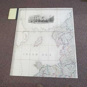
Add to basketNo Binding. Condition: Fair. Stains and edge wear to margins. With margin tear at upper left hand corner margin. Map unaffected. Map generally clean. Fair+ overall. Map drawn by Creighton & engraved by Dower.
 More images
Published by S. Lewis and Co. London, 1847
- Hardcover
- Map
Seller: Addyman Books, Hay-on-Wye, United KingdomAddyman Books
Contact seller5-star sellerCondition: Used
US$ 103.33
US$ 32.10 shippingShips from United Kingdom to U.S.A.Quantity: 1 available
Add to basketS. Lewis and Co. London. 1847. 35 x 42 inch folding coloured map, mounted on linen, in 35 sections (7 by 5). Housed in 20th century grey linen boards with a leather lettering piece - incorrectly stating "Maps of Wales". Some very light foxing otherwise clean and sound.
 More images
Published by S. Lewis & Co., London, 1841
- Hardcover
- Map
Seller: Andrew Cox PBFA, Shropshire, United KingdomAndrew Cox PBFA
Contact seller5-star sellerAssociation member: PBFA
Condition: Used - Good
US$ 344.42
US$ 26.08 shippingShips from United Kingdom to U.S.A.Quantity: 1 available
Add to basketHardcover. Condition: Good. Published in 1841, this is a very large linen backed folding Hand Coloured map of England & Wales, in four parts folding down into leather covers, opened each individual part measures 41.5 inches by 35 inches approx. Put together the whole map measures 83 inches by 70 inches approx. which is nearly 7…feet by 6 feet The leather covers are rubbed and worn at edges, there has been crude strengthening repairs to the spines The map itself has a few creases at edges, mild marking and foxing, else in overall good condition A GENERALLY NICE EXAMPLE OF THIS VERY LARGE EARLY VICTORIAN HAND COLOURED MAP OF ENGLAND AND WALES Maps are heavy, nearly three kilos packed, overseas shipping costs will be significantly higher than the basic standard quote. Drawn by R. Creighton, Engraved by J. Dower (illustrator).
 More images
Published by Samuel Lewis, 1865
- Hardcover
- Map
Seller: Morning Mist Books and Maps, Cirencester, United KingdomMorning Mist Books and Maps
Contact seller5-star sellerCondition: Used - Very good
US$ 344.42
US$ 60.19 shippingShips from United Kingdom to U.S.A.Quantity: 1 available
Add to basketHardcover. Condition: Very Good. Complete set of four maps in original bindings, mounted in sections on linen. Green cloth boards with gilt detailing and gilt titles to spines. Three with repairs to spines, one rebacked with part of the original relaid. All with wear to hinges but with later reinforcements to reverse, so binding…s are firm albeit with repairs. Corners rubbed and worn. Large calligraphic title and ornate compass. Table of extent of dioceses and another distances between ports. All maps with outline colouring to counties, clear printing and bold hachuring allowing the landscape to be clearly visible. Railways in blue with a * symbol denoting stations. The number of railways and inclusion of this symbol suggests a late printing for this map (usually dated 1839 at the base of the title but with this set, that date is absent). N.W. Sheet: minimal marking to reverse; no holes and no tears; a few spots to the map face; brown lateral lines across the face; sharp printing of the Post Office vignette. N.E. Sheet: some spotting to reverse and to map face; no holes and no tears; brown lateral lines across the map face and some 'ghosting' of the title. S.E. Sheet: minimal spotting to reverse; no holes and no tears; slight spotting and a few brown lines to map face. S.W. Sheet: minimal spotting to reverse; no holes and no tears; slight spotting and a few brown lines to map face. Dating is difficult as there is no railway shown to Penzance, with the line stopping at Plymouth (Royal Albert Bridge completed in 1859) but the railways along the North West appear almost complete. As a result, the date is estimated at around 1860-1870 for the additions. Each sheet size is 106cm by 88cm approx. Further details available on request. (non377bo20y).
 More images
Published by S. Lewis & Co., London, 1847
- Hardcover
Seller: Polar Books, Llandudno, CONWY, United KingdomPolar Books
Contact seller5-star sellerCondition: Used - Good
US$ 523.51
US$ 33.44 shippingShips from United Kingdom to U.S.A.Quantity: 1 available
Add to basketMap. Condition: Good. Dust Jacket Condition: Hardcovers. Early Edition. Full Title: Map of England & Wales Divided into Counties, Parliamentary Divisions and Dioceses. Shewing the Principal Roads, Railways, Rivers & Canals and the seats of the Nobility and Gentry. With the distance of each town from the General Post Office, Lond…on. Projected from the triangulation for the survey made under the Direction of the honorable The Board of Ordnance on a scale of five miles to an inch and corrected to the present time Drawn by R. Creighton, Engraved by J. Dower. Complete set of four maps in original bindings, mounted in sections on linen. Green cloth boards with gilt detailing and gilt titles to spines. An updated edition revised to include the development and growth of the railways in the early Victorian period. Each map is hand-coloured on folding linen, size 106cm by 90 cm, and each in 35 sections. A key provides information on cities, market towns, parishes and other townships, hamlets, rivers, gentlemen's seats, churches (and these are shown in 3 different categories), parks, mail roads, turnpike roads, canals, rail roads, mountains and various administrative divisions. A panel beneath the map with a series of crests gives details of the 20 dioceses in the province of Canterbury and the 5 in the province of York. The North-West sheet has a large engraving of the London Post Office and the North-East sheet a decorative compass rose beneath the title and key. Folds into original boards with decorated borders. All 4 maps are in good condition , the covers show shelf wear and some loss or rubbing to extremities, a small piece of leather is worn on the front cover of the NE map. An updated edition revised to include the development and growth of the railways in the early Victorian period. Dating is difficult as there is no railway shown to Penzance, with the line stopping at Plymouth (Royal Albert Bridge completed in 1859) but the railways along the North West appear almost complete. The amount of proposed railways suggests a date of around 1847 to 1850. Quantity Available: 1. Shipped Weight: Under 5 kilogram. Category: Geography & Maps; Railways. Pictures of this item not already displayed here available upon request. Inventory No: 3967. This is a SET of books, therefore heavier than a standard volume, and will involve extra shipping charges to some countries.

Published by LondonEdward Stanford Map Seller and Map Mounter to Her Majesty's Stationary Office 6 Charing Cross. ., 1873
- Hardcover
- Map
Seller: Robert Frew Ltd. ABA ILAB, London, United KingdomRobert Frew Ltd. ABA ILAB
Contact seller5-star sellerCondition: Used
US$ 2,066.50
US$ 13.38 shippingShips from United Kingdom to U.S.A.Quantity: 1 available
Add to basketLarge hand-coloured engraved map backed (by being sewn at edges) onto green cloth, displayed on contemporary pull down wall roller (mechanism not working). Overall dimensions of the map 207 x 169 cm. Inset A List of the principal ports in England & Wales, left centre and inset of the Extent of the Several Dioceses, lower right.…Three small light brown patches across horizontal line of lower third, area of text at lower margin slightly cracked, generally a very good example ot his highly impressive and uncommon wall map. First issued 1859. Normally found on 4 separate sheets, here joined to make a fine display.
 More images
Published by Samuel Lewis, 1850
- Map
Seller: Morning Mist Books and Maps, Cirencester, United KingdomMorning Mist Books and Maps
Contact seller5-star sellerCondition: Used - Good
US$ 57.86
US$ 60.19 shippingShips from United Kingdom to U.S.A.Quantity: 1 available
Add to basketNo Binding. Condition: Good. From Lewis's Map of England and Wales, being only one of the sheets: the N. E. section containing the calligraphic title and the eastern coast from Holy Island to The Wash. Original publication date is 1839 but there are some later railway additions, c.1850. Original boards present but the rear one d…etached. Spine to boards almost non-existent. No holes or tears to folds. Light dust-marking to map face and light spotting. Some discolouring to the rear but nothing major. Full colour. Clear printing. Fine hachuring. Sheet size when open: 106cm by 90cm approx. More details available on request. (non372med).
 More images
Published by Edward Stanford Ltd, London, 1856
Seller: George Jeffery Books, HERTFORDSHIRE, United KingdomGeorge Jeffery Books
Contact seller5-star sellerAssociation member: PBFA
Condition: Used - Very good
US$ 861.04
US$ 33.44 shippingShips from United Kingdom to U.S.A.Quantity: 1 available
Add to basketCondition: Very Good. Very large linen backed coloured map, in 4 parts, each part in 30 secition. Map measures 208x178.cm. [ 82x70 inches ]. Some very minor wear. Map in very good clean condition. Without slipcase. F. R. Creighton. Engraved By J. Dower (illustrator).


