Desilver Charles (42 results)

Hanging Loose 88
Hershon, Robert; Lourie, Dick; Pawlak, Mark; Shreiber, Ron; Jarrett, Emmett; Anderson, Jack; Beal, Stephen; Brook, Donna; Cortez, Jayne; DeSilver, Albert Flynn; Espada, Martin; Fleming, Gerald; Gilfillan, Merrill; Jacquette, Yvonne; Kicknosway, Faye; Koestenbaum, Wayne; Marcus, Morton; Maurer-Alvarez, Pansy; Nelson, Cynthia; Ne;son, Maggie; Olin, Jeni; Schneider, Mather; Sedarat, Roger; Ulland, Matthew; White, Sarah; Wyatt, Charles; Zavatsky, Bill; Zheng, Jiaqing; Beer, Joanna; Cotsirlos, Teresa; Cummins, Megan; Johnson, Carolyn; Lander, Jessica; Landau, Caroline C.; Meacham, Jacob; Miller, Fiona; et al
Language: English
Published by Hanging Loose Press, Brooklyn, New York, 2006
- Softcover
- First Edition
Seller: Village Works, New York, NY, U.S.A.Village Works
Contact seller4-star sellerSoft cover. Condition: Fine. 1st Edition. ISSN # 0440-2316. From the collection of Robert Hershon.
Hanging Loose 88
Hershon, Robert; Lourie, Dick; Pawlak, Mark; Shreiber, Ron; Jarrett, Emmett; Anderson, Jack; Beal, Stephen; Brook, Donna; Cortez, Jayne; DeSilver, Albert Flynn; Espada, Martin; Fleming, Gerald; Gilfillan, Merrill; Jacquette, Yvonne; Kicknosway, Faye; Koestenbaum, Wayne; Marcus, Morton; Maurer-Alvarez, Pansy; Nelson, Cynthia; Ne;son, Maggie; Olin, Jeni; Schneider, Mather; Sedarat, Roger; Ulland, Matthew; White, Sarah; Wyatt, Charles; Zavatsky, Bill; Zheng, Jiaqing; Beer, Joanna; Cotsirlos, Teresa; Cummins, Megan; Johnson, Carolyn; Lander, Jessica; Landau, Caroline C.; Meacham, Jacob; Miller, Fiona; et al
Published by Hanging Loose Press, Brooklyn, New York, 2006
- Softcover
- First Edition
Seller: Village Works, New York, NY, U.S.A.Village Works
Contact seller4-star sellerSoft cover. Condition: Fine. 1st Edition. ISSN # 0440-2316. From the collection of Robert Hershon.

- Softcover
Seller: Ria Christie Collections, Uxbridge, United KingdomRia Christie Collections
Contact seller5-star sellerCondition: New
US$ 62.73
US$ 15.91 shippingShips from United Kingdom to U.S.A.Quantity: Over 20 available
Condition: New. In.
Published by Desilver, Charles, Philadelphia, 1856
Seller: Argosy Book Store, ABAA, ILAB, New York, NY, U.S.A.Argosy Book Store, ABAA, ILAB
Contact seller5-star sellerCondition: Used - Very good
US$ 75.00
US$ 6.00 shippingShips within U.S.A.Quantity: 1 available
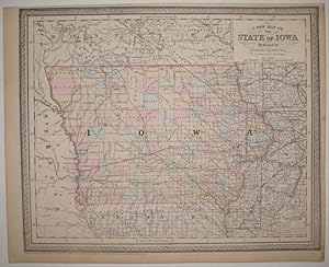
unbound. Condition: very good(+). Map. Engraving with original hand coloring. Image measures 13" x 16". Nice clear map of Iowa divided into counties. Showing towns, major routes, railroads and waterways. From the "New Universal Atlas". Plate was originally published by Samuel Augustus Mitchell, who sold the copyright to Thomas,…Cowperthwait & Company in 1850, which was in turn bought by Charles Desilver in 1856. Top margin slightly cropped, light scattered staining.

Published by Charles Desilver, Philadelphia, 1856
- Map
Seller: mediumraremaps.com, Franklin, TN, U.S.A.mediumraremaps.com
Contact seller4-star sellerCondition: Used - Very good
US$ 85.00
US$ 6.00 shippingShips within U.S.A.Quantity: 1 available
13 1/4 x 15 3/4 inches. Condition: Very good condition. This map ante-bellum map was compiled as a transportation map with primary focus on railroads. The map's key has railroads, railroads in progress and railroads proposed. A comprehensive network encompasses al three. The map is highlighted with very nice contemporary colorin…g. Roads connecting county seats are also reflected as double lines. this id a truly important map of the states transportation systems executed in great detailed.
 More images
Published by Philadelphia, Philadelphia, 1857
- Hardcover
Seller: High Ridge Books, Inc. - ABAA, South Deerfield, MA, U.S.A.High Ridge Books, Inc. - ABAA
Contact seller5-star sellerFolding map in original cloth folder. Light age toning, small separations at some fold junctions with no loss. Full color by county. A scarce separate issue of Charles DeSilver's map from his atlas of the United States. Originally, DeSilver's maps derived from the Mitchell/Thomas, Cowperthwait Unisveral Atlas maps.This map shows… the significant progress of the railroads throughout the state.
 More images
Published by Philadelphia, Philadelphia, 1859
- Hardcover
Seller: High Ridge Books, Inc. - ABAA, South Deerfield, MA, U.S.A.High Ridge Books, Inc. - ABAA
Contact seller5-star seller2 folding mapsheets bound together in original tooled leather folder with the title "Europe" gilt on front. fine condition. Full color by country. The left-hand sheet has a sheet with two maps: The Austrian Empire and the Kingdom of Sardinia. At this time, Sardinia included not only the island, but also the southeastern province…s of France (including Nice and Savoy), and the northwestern provinces of Italy, (including Genoa and the Piedmont). The right-hand map is of Europe, with tables of information along the sides. Neither of these maps was issued in any of the atlases of the period published by DeSilver.
 More images
Published by Published by Charles Desilver, 1857., Philadelphia, 1857
- Hardcover
- First Edition
Seller: BUCKINGHAM BOOKS, ABAA, ILAB, IOBA, GREENCASTLE, PA, U.S.A.BUCKINGHAM BOOKS, ABAA, ILAB, IOBA
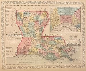
Contact seller5-star seller[LOUISIANA]. First edition. 14 5/8" x 17 3/4" color map of Louisiana with a 4 1/2" x 5" color inset map of New Orleans with references to points of interest, parishes, towns, and cities in Louisiana. Also information on steam boat routes is provided. Includes distance tables of "New Orleans to Pittsburg," "New Orl. to Natchitoch…es" and "N. Orleans to the Balize." Top right corner offers an inset map of New Orleans. Map is in near fine condition with two tiny splits at two folds. Map is housed in a 5 1/4" x 3 3/8" embossed cloth covers with a bookseller's label affixed to the inside front cover and a small cosmetic repair to the lower spine panel. Overall a near fine copy of a beautiful map of Louisiana.

Published by Cowperthwait, Philadelphia, 1857
Seller: Argosy Book Store, ABAA, ILAB, New York, NY, U.S.A.Argosy Book Store, ABAA, ILAB
Contact seller5-star sellerunbound. Map. Lithograph with original hand coloring. Image measures 14" x 17". This lovely 1857 map of Ontario, Canada depicts the province in its entirety. The map includes part of New York State as well. "Canada West," previously known as "Upper Canada" is color coded at the district level and notes railroads, cities, rivers,… mountains, and other important topographic elements. Mississauga First Nation territory is noted. An inset in the lower right features Vicinity of the Falls of Niagara as well as an inset of the City of Toronto and it's Environs The map is in good condition. Charles Desilver (fl. 1856-1862) was a Philadelphia based map publisher active in the mid 19th century. He purchased the copyright for Mitchell's 'New Universal Atlas', publishing his own editions in 1856 and 1857. The maps from these editions were updated with the most recent information, especially related to roads, canals, and railways.
Published by Thomas, Cowperthwait & Co, Philadelphia, 1857
Seller: Argosy Book Store, ABAA, ILAB, New York, NY, U.S.A.Argosy Book Store, ABAA, ILAB
Contact seller5-star sellerCondition: Used - Very good
US$ 125.00
US$ 6.00 shippingShips within U.S.A.Quantity: 1 available
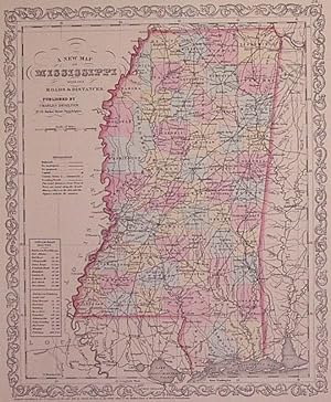
unbound. Condition: very good(+). Map. Engraving with original hand coloring. Image measures 14" x 11.5". Nice clean map of Mississippi divided into counties. Shows major cities, major routes, waterways and railroads. Includes table of steam boat routes. From the "New Universal Atlas". In excellent condition. Plate was originall…y published by Samuel Augustus Mitchell, who sold the copyright to Thomas, Cowperthwait & Company in 1850, which was in turn bought by Charles Desilver in 1856.
Published by Desilver, Charles, Philadelphia, 1857
Seller: Argosy Book Store, ABAA, ILAB, New York, NY, U.S.A.Argosy Book Store, ABAA, ILAB
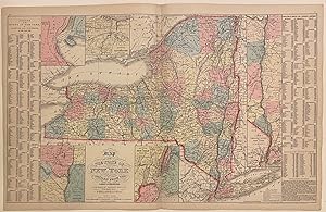
Contact seller5-star sellerunbound. Map. Engraving with original hand coloring. Image measures 16" x 26 1/8" Nice clear map of New York divided into counties. Shows towns, major routes, railroads, waterways, and topographical features. Insets include the vicinities of Albany, New York City, Rochester, and Niagara Falls, and a Map of the Hudson River from…New York to Albany. On either side of the map is a table listing populations of counties and townships, square miles of counties, and other miscellaneous statistics. From the "New Universal Atlas". Plate was originally published by Samuel Augustus Mitchell, who sold the copyright to Thomas, Cowperthwait & Company in 1850, which was in turn bought by Charles Desilver in 1856. Charles Desilver (fl. 1856-1862) was a Philadelphia based map publisher active in the mid 19th century. He purchased the copyright for Mitchell's 'New Universal Atlas', publishing his own editions in 1856 and 1857. The maps from these editions were updated with the most recent information, especially related to roads, canals, and railways.

Published by Charles Desilver, Philadelphia, 1856
Seller: Argosy Book Store, ABAA, ILAB, New York, NY, U.S.A.Argosy Book Store, ABAA, ILAB
Contact seller5-star sellerunbound. Map. Engraving with original hand coloring. Image measures 15 1/4" x 12". Classic 19th century map of Maine divided into counties, showing towns, major routes, waterways and railroads. Includes a table in the upper left corner showing counties and their populations in 1840 and 1850, as well as population growth of the s…tate from 1765 to 1850. This map was published in Desilver's 1856 edition of the "New Universal Atlas". In excellent condition. Charles Desilver (fl. 1856-1862) was a Philadelphia based map publisher active in the mid 19th century. He purchased the copyright for Mitchell's "New Universal Atlas", publishing his own editions in 1856 and 1857. The maps from these editions were updated with the most recent information, especially related to roads, canals, and railways.
Published by Charles Desilver, Philadelphia, 1858
Seller: Argosy Book Store, ABAA, ILAB, New York, NY, U.S.A.Argosy Book Store, ABAA, ILAB
Contact seller5-star sellerunbound. Map. Engraving with original hand coloring. Image measures 14 3/4" x 11 3/4" Lovely map of Louisiana divided into counties. Shows major cities, major routes, waterways and railroads. Includes inset showing New Orleans. A table in the upper left indicates steam boat routes from New Orleans to Pittsburgh, to Natchitoches,… and to Balize. Chips and tonign to margins. This map was published in Desilver's 1856 edition of the "New Universal Atlas". In excellent condition. Charles Desilver (fl. 1856-1862) was a Philadelphia based map publisher active in the mid 19th century. He purchased the copyright for Mitchell's "New Universal Atlas", publishing his own editions in 1856 and 1857. The maps from these editions were updated with the most recent information, especially related to roads, canals, and railways. J. L. Hazzard (illustrator).
Published by Desilver, Charles, Philadelphia, 1856
Seller: Argosy Book Store, ABAA, ILAB, New York, NY, U.S.A.Argosy Book Store, ABAA, ILAB
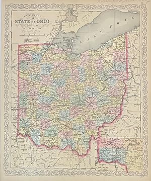
Contact seller5-star sellerunbound. Map. Engraving with original hand coloring. Image measures 16" x 13" Classic map of Ohio divided into counties. Showing towns, major routes, railroads and waterways. Includes an inset view showing the Vicinity of Cincinnati. In excellent condition. Charles Desilver (fl. 1856-1862) was a Philadelphia based map publisher…active in the mid 19th century. He purchased the copyright for Mitchell's "New Universal Atlas", publishing his own editions in 1856 and 1857. The maps from these editions were updated with the most recent information, especially related to roads, canals, and railways.
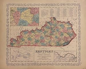
Published by Charles Desilver, Philadelphia, 1856
Seller: Argosy Book Store, ABAA, ILAB, New York, NY, U.S.A.Argosy Book Store, ABAA, ILAB
Contact seller5-star sellerunbound. Map. Engraving with original hand coloring. Image measures 14" x 11.5". Nice clean map of Kentucky divided into counties. Shows major cities, major routes, waterways and railroads. Includes table of steam boat routes. Includes insets showing larger scale depictions of roads surrounding Lexington, and along the Ohio Rive…r near Clarksburg, and at the Falls of Ohio near Louisville. A table in the upper right corner indicates steam boat routes from Louisville to Pittsburgh, and from Louisville to New Orleans. From the "New Universal Atlas". In very good condition with minor wear to margins, not affecting the image. Plate was originally published by Samuel Augustus Mitchell, who sold the copyright to Thomas, Cowperthwait & Company in 1850, which was in turn bought by Charles Desilver in 1856.

Published by H. N. Burroughs, Philadelphia, 1856
Seller: Argosy Book Store, ABAA, ILAB, New York, NY, U.S.A.Argosy Book Store, ABAA, ILAB
Contact seller5-star sellerunbound. Map. Lithograph with original hand coloring. Philadelphia: H.N. Burroughs, 1846. Image measures 12" x 15" Detailed map of the Grecian Archipelago. An inset in the lower left corner depicts the island of Candia (Crete). The map is labeled with towns, rivers, and islands. In very good condition, with uneven borders. Samue…l Augustus Mitchell Sr. (1792-1868) published this map as part of the first edition of his seminal New Universal Atlas. Mitchell is one of the pioneers in American cartography of the 19th century and led the conversion of engraved map plates to more affordable lithographic plates. Charles Desilver (fl. 1856-1862) was a Philadelphia based map publisher active in the mid 19th century. He purchased the copyright for Mitchell's 'New Universal Atlas', publishing his own editions in 1856 and 1857. The maps from these editions were updated with the most recent information, especially related to roads, canals, and railways. Henry Tanner (illustrator).

Published by Charles Desilver, Philadelphia, 1856
Seller: Argosy Book Store, ABAA, ILAB, New York, NY, U.S.A.Argosy Book Store, ABAA, ILAB
Contact seller5-star sellerunbound. Map. Engraving with original hand coloring. Image measures 12.25" x 15". This classic map of Mexico was published shortly after the end of the Mexican-American War. It features an inset of the Valley of Mexico at lower left, and three insets along the top show maps of "Guatemala or Central America", "the Isthmus of Tehu…antepec showing the proposed route from the Gulf of Mexico to the Pacific Ocean (the proposed trans-continental canal was never built)", and "the Isthmus or Nicaragua showing the proposed routes from The Caribbean Sea to the Pacific Ocean". Several cities, towns, canals, and topographic details are noted throughout the map. Both proposed and realized trade routes are noted. From the "New Universal Atlas". The plate was originally published by Samuel Augustus Mitchell, who sold the copyright to Thomas, Cowperthwait & Company in 1850, which was in turn bought by Charles Desilver in 1856. The map is in good condition with minor foxing. Charles Desilver (fl. 1856-1862) was a Philadelphia based map publisher active in the mid 19th century. He purchased the copyright for Mitchell's New Universal Atlas, publishing his own editions in 1856 and 1857. The maps from these editions were updated with the most recent information, especially related to roads, canals, and railways.
Published by Charles Desilver, Philadelphia, 1856
Seller: Argosy Book Store, ABAA, ILAB, New York, NY, U.S.A.Argosy Book Store, ABAA, ILAB
Contact seller5-star sellerunbound. Map. Engraving with original hand coloring. Image measures 14 3/4" x 11 3/4" Lovely map of Louisiana divided into counties. Shows major cities, major routes, waterways and railroads. Includes inset showing New Orleans. A table in the upper left indicates steam boat routes from New Orleans to Pittsburgh, to Natchitoches,… and to Balize. This map was published in Desilver's 1856 edition of the "New Universal Atlas". In excellent condition. Charles Desilver (fl. 1856-1862) was a Philadelphia based map publisher active in the mid 19th century. He purchased the copyright for Mitchell%u2019s %u201CNew Universal Atlas%u201D, publishing his own editions in 1856 and 1857. The maps from these editions were updated with the most recent information, especially related to roads, canals, and railways.

Published by Charles Desilver, Philadelphia, 1856
Seller: Argosy Book Store, ABAA, ILAB, New York, NY, U.S.A.Argosy Book Store, ABAA, ILAB
Contact seller5-star sellerunbound. Map. Engraving with original hand coloring. Image measures 11 1/2" x 15 3/8" Nice clean map of Tennessee divided into counties. Shows major cities, major routes, waterways and railroads. Includes table of steam boat routes. Includes two insets showing "Environs of Nashville" and "Environs of Knoxville". From the "New Un…iversal Atlas". In excellent condition. Plate was originally published by Samuel Augustus Mitchell, who sold the copyright to Thomas, Cowperthwait & Company in 1850, which was in turn bought by Charles Desilver in 1856. Charles Desilver (fl. 1856-1862) was a Philadelphia based map publisher active in the mid 19th century. He purchased the copyright for Mitchell%u2019s %u201CNew Universal Atlas%u201D, publishing his own editions in 1856 and 1857. The maps from these editions were updated with the most recent information, especially related to roads, canals, and railways.

Published by Charles Desilver, Philadelphia, 1856
Seller: Argosy Book Store, ABAA, ILAB, New York, NY, U.S.A.Argosy Book Store, ABAA, ILAB
Contact seller5-star sellerunbound. Map. Engraving with original hand coloring. Image measures 12 x 15" Classic 19th century map of Washington D. C. divided into hand colored wards, showing towns, major routes, waterways, railroads and bridges. Includes a table in the lower left with wards and sites listed. This map was published in Desilver's 1856 editio…n of the "New Universal Atlas". In very good condition. Charles Desilver (fl. 1856-1862) was a Philadelphia based map publisher active in the mid 19th century. He purchased the copyright for Mitchell's "New Universal Atlas", publishing his own editions in 1856 and 1857. The maps from these editions were updated with the most recent information, especially related to roads, canals, and railways.
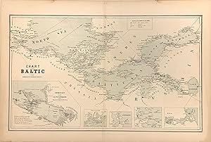
Published by William Boell, New York, 1857
Seller: Argosy Book Store, ABAA, ILAB, New York, NY, U.S.A.Argosy Book Store, ABAA, ILAB
Contact seller5-star sellerunbound. Map. Color lithograph. Image measures 11.75" x 14.25". This scarce chart of the Baltic Sea is exceptional for its precise rendering of the coastlines between Scandinavia and the coast of Western Europe. The waters of the central Baltic Sea extend outward into the Gulfs of Bothnia and Finland in the west and the North Se…a in the East. Along the coasts, towns, forts, and lighthouses are labeled and establish a level of detail that carries over into the five insets along the bottom of the map. The largest, showing Coronstadt and St. Petersburg, includes multiple useful tips for navigators that identify dangerous conditions. The other four Sveaborg, Port Baltic, Reval, and Riga highlight some of the bustling ports in this significant region of European waterways. The map is in very good condition with full margins as issued. Light staining around edges not affecting the image. Map is bright and clean except for some slight discoloration along the center fold. It first appeared in Charles Desilver's edition of S.A. Mitchell's "New Universal Atlas" as published in 1856. This edition was published in New York by Boell.

Published by Philadelphia, 1856
Seller: William Chrisant & Sons, ABAA, ILAB. IOBA, ABA, Ephemera Society, Fort Lauderdale, FL, U.S.A.William Chrisant & Sons, ABAA, ILAB. IOBA, ABA, Ephemera Society
Contact seller5-star sellerCondition: Used - Very good
US$ 450.00
US$ 9.00 shippingShips within U.S.A.Quantity: 1 available
Condition: Very Good. Scarce contemporary hand colored map of Florida from the 1856 edition of Desilver's A New Universal Atlas. In comparison to Desilver's earlier maps of Florida, a decorative border is present here with a smaller Gulf of Mexico. The map measures approximately 12 x 14.5 in (30.5 x 37 cm); paper size is 14 x 17… in (35.5 x 43 cm). Minor foxing predominantly affecting verso (see image). Small tape repair to right edge.
 More images
Published by Charles Desilver, Philadelphia, 1859
Seller: Rulon-Miller Books (ABAA / ILAB), St. Paul, MN, U.S.A.Rulon-Miller Books (ABAA / ILAB)
Contact seller5-star sellerHand-colored folding pocket map approx. 13¼" x 16½" showing the two states, with an inset of Boston and a population statistical table. Very good, no breaks at the folds. Boston Public, AAS, and Harvard only in OCLC.

Seller: Art Source International Inc., Boulder, CO, U.S.A.Art Source International Inc.
Contact seller5-star sellerWe are pleased to offer this rare map published by Charles Desilver, Philadelphia, 1856. In 1836 Henry Tanner published his first atlas. S. Augustus Mitchell acquired the publishing rights to Tanners atlas in 1846 and continued publishing it until 1849. In 1850 the copyright to Mitchell's atlas was acquired by Thomas Cowperthwai…t & Co. and was subsequently acquired by Charles Desilver in 1856. This map by Desilver is truly an American rarity. We consider maps by Desilver to be some of the most visually appealing of any map from this time period. His original hand-coloring is dramatic. A collection would not be complete without a map by Charles Desilver. This map measures 16 inches by 13 inches.
The new village harmony; : a musical manual for Sabbath schools: : containing old and new sacred tunes harmonized in an easy style, in two and three parts; and adapted also for the use of small choirs and conference meetings 1835 [LeatherBound]
Zeuner, Charles comp,Davis, Robert Sharp publisher,Rand, Asa bookseller,Bixby, Daniel, bookseller,Whipple, Henry bookseller,Butler, Jonathan Hunt, 1804 or 5, bookseller,Hyde, William bookseller,Hyde, Henry bookseller,Lane, Edmund James bookseller,Ide, Simeon bookseller,Steele, Oliver bookseller,Allen, Ira Mason bookseller,Crocker & Brewster, publisher,Lyman Thurston & Co., stereotyper,Dorr, Howland & Co., bookseller,Dole, Redington & Co., bookseller,Marsh, Capen, and Lyon, bookseller,Marshall, Brown & Co., bookseller,Beckwith & Co. (Cleveland, Ohio), bookseller,Beach & Beckwith, bookseller,Leavitt, Lord, and Co., bookseller,Moore and Payne, bookseller,Bennett & Bright, bookseller,Desilver, Thomas & Co., bookseller,Cushing & Sons, bookseller
- Hardcover
- Print on Demand
Seller: True World of Books, Delhi, IndiaTrue World of Books
Contact seller5-star sellerLeatherBound. Condition: New. BOOKS ARE EXEMPT FROM IMPORT DUTIES AND TARIFFS; NO EXTRA CHARGES APPLY. LeatherBound edition. Condition: New. Reprinted from 1835 edition. Leather Binding on Spine and Corners with Golden leaf printing on spine. NO changes have been made to the original text. This is NOT a retyped or an ocr'd repri…nt. Illustrations, Index, if any, are included in black and white. Each page is checked manually before printing. Pages: 228 As this print on demand book is reprinted from a very old book, there could be some missing or flawed pages, but we always try to make the book as complete as possible. Fold-outs, if any, are not part of the book. If the original book was published in multiple volumes then this reprint is of only one volume, not the whole set. Sewing binding for longer life, where the book block is actually sewn (smythe sewn/section sewn) with thread before binding which results in a more durable type of binding. Pages: 228 Language: English.
- Softcover
- Print on Demand
Seller: PBShop.store US, Wood Dale, IL, U.S.A.PBShop.store US
Contact seller5-star sellerCondition: New
US$ 67.93
Free ShippingShips within U.S.A.Quantity: Over 20 available
PAP. Condition: New. New Book. Shipped from UK. THIS BOOK IS PRINTED ON DEMAND. Established seller since 2000.
- Softcover
- Print on Demand
Seller: PBShop.store UK, Fairford, GLOS, United KingdomPBShop.store UK
Contact seller5-star sellerCondition: New
US$ 63.38
US$ 7.79 shippingShips from United Kingdom to U.S.A.Quantity: Over 20 available
PAP. Condition: New. New Book. Delivered from our UK warehouse in 4 to 14 business days. THIS BOOK IS PRINTED ON DEMAND. Established seller since 2000.

Seller: Art Source International Inc., Boulder, CO, U.S.A.Art Source International Inc.
Contact seller5-star sellerWe are pleased to offer this rare map published by Charles Desilver, Philadelphia, 1856. In 1836 Henry Tanner published his first atlas. S. Augustus Mitchell acquired the publishing rights to Tanners atlas in 1846 and continued publishing it until 1849. In 1850 the copyright to Mitchell's atlas was acquired by Thomas Cowperthwai…t & Co. and was subsequently acquired by Charles Desilver in 1856. This map by Desilver is truly an American rarity. We consider maps by Desilver to be some of the most visually appealing of any map from this time period. His original hand-coloring is dramatic. A collection would not be complete without a map by Charles Desilver. This map measures 10.5 inches by 12.5 inches.

Seller: Art Source International Inc., Boulder, CO, U.S.A.Art Source International Inc.
Contact seller5-star sellerWe are pleased to offer this rare map published by Charles Desilver, Philadelphia, 1856. In 1836 Henry Tanner published his first atlas. S. Augustus Mitchell acquired the publishing rights to Tanners atlas in 1846 and continued publishing it until 1849. In 1850 the copyright to Mitchell's atlas was acquired by Thomas Cowperthwai…t & Co. and was subsequently acquired by Charles Desilver in 1856. This map by Desilver is truly an American rarity. We consider maps by Desilver to be some of the most visually appealing of any map from this time period. His original hand-coloring is dramatic. A collection would not be complete without a map by Charles Desilver. This map measures 15 inches by 12.5 inches.


