Drafting Institute (4 results)
 More images
Published by Sahab Geographic and Drafting Institute and Persepolis, Publisher and Bookseller. 1967
- Softcover
- First Edition
Seller: Ivan's Book Stall, Reading, United KingdomIvan's Book Stall
Contact seller5-star sellerCondition: Used - Good
US$ 67.48
US$ 29.42 shippingShips from United Kingdom to U.S.A.Quantity: 1 available
Soft cover. Condition: Good. 1st Edition. 205 numbered pages with foldout maps followed by approx 32 pages of grainy photographic reproductions. Frontispiece pictures of Shah and family.
 More images
Published by Sahab Geographic and Drafting Institute and Persepolis Publishing and Bookseller, Tehran 1967
- Softcover
- First Edition
Seller: Dendera, London, United KingdomDendera
Contact seller5-star sellerCondition: Used - Good
US$ 206.58
US$ 33.43 shippingShips from United Kingdom to U.S.A.Quantity: 1 available
Soft cover. Condition: Good. 1st Edition. First edition, 1967 as indicated, "Published on the glorious occasion of the coronation of their Imperial Majesties Shahanshah Aryamehr and Shahbanu Farah". Original wraps ornately illustrated in green and gilt 12x17cm. XV, 205, (32)pp captioned b/w photos, with text translated from the…original Farsi into English by A. Noorian. This calls for 12 maps, folding, either bound in or loose. There are 12 present, but include Kerman (not called for), and omit Tehran (called for, but not present), with the Iran Road Map and Persepolis together on a single loose sheet. Covers otherwise very good, creased at the spine, and interiors near fine. Part One presents a "general sketch" covering a wide range of subjects pertaining to history, geography, culture, oil, religion, vocab, seasons, diplomatic missions, hunting and fishing, etc. Part Two, the main part (pp82ff) presents a "guide to famous cities", including Tehran, Isfahan, Shiraz, Ahwaz, Khorramshahr, Abadan, Qazvin, Hamedan, Kermanshah, Rasht, Tabriz, Sari, Mashhad, Yazd, and Kerman. The frontis portraits feature a portrait of the Imperial Family, and the Crown Prince viewing the first Persian lettered globe published by Sahab GDI. Scarce (Worldcat also records a 2nd revised edition, 1977).
 More images
Map of the Iranian Railways Network and the Future Projects WITH Facts and Figures - 1973-74 Railway Edition
Iranian State Railways (RAI) Planning and Studies Department; Sahab Geographic and Drafting Institute; Hamid Moussavian
Published by Iranian State Railways; Imperial Government of Iran Ministry of Roads and Transportation, Tehran 1975
- Softcover
Seller: Dendera, London, United KingdomDendera
Contact seller5-star sellerCondition: Used - Very good
US$ 309.87
US$ 33.43 shippingShips from United Kingdom to U.S.A.Quantity: 1 available
Soft cover. Condition: Very Good. Two related items offered together: 1. Colour paper folding "Map of the Iranian Railways Network and the Future Projects", published by Iranian Railways March 1975, cartography by Sahab Geographic and Drafting Institute, Tehran 43 x 31cm. Details include existing lines, stations (distinguishing…central, 1st, 2nd, 3rd class and other), lines to be constructed according to the 5th, 6th, 7th, and 8th Five Year Plans by order of priority, and distances in km. Fine, neatly folded. / 2. Facts & Figures 1973-74 Railway Edition, booklet in b/w illustrated wraps, 15 x 22cm, 64pp illustrated in colour and b/w. Prepared by the Planning & Studies Department, printed at Iranian State Railways Printing Office. Very good, lightly worn, with short tear to spine head, and German institutional inkstamps to outer and inner front wrap (one of which is over-stamped "ungultig"). The text includes a progress report by Hamid Moussavian, Deputy Minister for Transport Affairs, Manager of the Railways; Brief History of the Iranian State Railways; and General Information regarding the Link between Iranian and Turkish Railways. Photos include royal portraits in colour, and b/w photos of Iran's railways. The tables and charts cover permanent installations (characteristics of the lines, tunnels, bridges, crossings, renewals etc), traction (locomotive power, carrying stock etc), and operations (tariffs, passenger traffic, goods traffic, items carried, etc). The map is rare, with 3 holdings located on Worldcat (Kansas University, Utah University, National Library of Australia). The booklet is scarce, with various editions recorded on Worldcat and Jisc from the 1950s up to 1977.
Published by Sahab Geographic & Drafting Institute, Tehran
Seller: Argosy Book Store, ABAA, ILAB, New York, U.S.A.Argosy Book Store, ABAA, ILAB
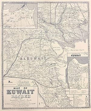
Contact seller5-star sellerMap. Lithograph. Measures 25 1/4 x 21 1/4". Fascinating map of Kuwait in vivid detail. International boundaries, railways, motor routes, rivers, and wells are labeled, with clearly rendered topographical detail showing marshes, hills, cliffs, dunes, and date palms. Inset maps features a town plan of the capital of Kuwait, and a…map of the capital city and its environs. First published in 1961, this copy is the 3rd edition, printed in 1965. Text is in English. In excellent condition. Fold lines as issued. Sahab Geographic & Drafting Institute, founded in Tehran in 1935 by Abolghasem Sahab and his son Abbas Sahab, was the first private geographic and cartographic institute in the Middle East. Abolghasem Sahab was a prominent Iranian writer and publisher, while his son Abbas (1921-2000) became known as the 'Father of Iranian Cartography', producing over 1500 works for the firm. This map was likely drafted by Abbas Sahab. Some Persian text.


