Order Total (1 Item Items):
Shipping Destination:

Dripps Matthew (3 results)
Skip to main search results
Search filters
Product Type
- All Product Types
- Books (1)
- Magazines & Periodicals (No further results match this refinement)
- Comics (No further results match this refinement)
- Sheet Music (No further results match this refinement)
- Art, Prints & Posters (No further results match this refinement)
- Photographs (No further results match this refinement)
- Maps (2)
- Manuscripts & Paper Collectibles (No further results match this refinement)
Condition Learn more
- New (No further results match this refinement)
- As New, Fine or Near Fine (No further results match this refinement)
- Very Good or Good (1)
- Fair or Poor (No further results match this refinement)
- As Described (2)
Binding
- All Bindings
- Hardcover (1)
- Softcover (No further results match this refinement)
Collectible Attributes
- First Edition (No further results match this refinement)
- Signed (No further results match this refinement)
- Dust Jacket (No further results match this refinement)
- Seller-Supplied Images (3)
- Not Print on Demand (3)
Language (1)
Price
- Any Price
- Under US$ 25 (No further results match this refinement)
- US$ 25 to US$ 50 (No further results match this refinement)
- Over US$ 50
Free Shipping
- Free Shipping to U.S.A. (No further results match this refinement)
Seller Location
Seller Rating
-
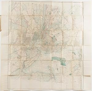
Topographical Map of New York and Vicinity Embracing Fifteen Cities and Above 1700 Square Miles
Published by M. Dripps, New York, 1870
Seller: Donald A. Heald Rare Books (ABAA), New York, NY, U.S.A.
Seller rating 5 out of 5 stars

Map
Hand-coloured lithographic folding map (sheet size: 28 x 28 inches), within a brown cloth wallet (5 1/4 x 3 1/4 inches), (splits at folds). Two insets: Map of Long Branch [NJ] and Vicinity; Navesink Park. 1p. publisher's price list tipped onto front pastedown. A fine example of this important map, published at a period of change for the city and its environs. A detailed map of metropolitan New York and its environs, which extends as far east on Long Island as Oyster Bay. Shows rapid transit system, canals, and railroads. Contains an interesting catalogue of Dripps' maps. "Checklist of Maps and Atlases relating to the city of New York in the New York Public Library" in the Bulletin of the New York Public Library, volume V (New York: 1901), p.69; not in Rumsey.
-

Map of Brooklyn and Vicinity.
Published by M. Dripps,, New York,, 1873
Seller: Daniel Crouch Rare Books Ltd, London, United Kingdom
Association Member: ABA ILAB PBFA
Seller rating 4 out of 5 stars

Map
US$ 1,659.18
US$ 26.85 shipping
Ships from United Kingdom to U.S.A.Quantity: 1 available
Add to basketBrooklyn as the third largest city in the United States Folding lithographed pocket map with contemporary hand-colour in full, tipped-in to blue cloth gilt covers, some separations and toning at old folds. Dripps' first map dedicated to Brooklyn was published in 1864. Between then and when he published the current map nearly ten years later, the third largest city in the United States, as it was then, had grown exponentially in terms of both population and geography. In 1873 Brooklyn extends north to Newtown Creek, east and southeast to Flatbush, south to 59th Street, and is bounded by the Buttermilk Canal and the East River to the West. Wards are colour-coded and numbered, with the location of XXI, XXIII, XXIV and XXV being overstamped as subdivisions of the old 21st ward, which contained Bedford. It would be another 25 years before Brooklyn extended to include all of Kings County, and was annexed as a borough of New York. The map is extremely detailed, with all major and minor road and rail routes outlined and complemented by a myriad of ferry routes that connect Long Island to Manhattan and the mainland. The ghostly outline of the future Brooklyn Bridge, which was under construction from 1869, is a testament to the increasing number of commuters into Manhattan. Real estate ownership is meticulously recorded for all plots, large and small. Green spaces, including the relatively newly designated Prospect Park, are colour coded. A guide pasted to the inside front cover lists all the stops on the 'Horse Car Railroad Routes from Fulton Ferry'; the 'Horse Car Railroad Routes from Broadway Ferry, E.D.'; and the 'Brooklyn Central Elevated Railroad, Proposed Line', which includes a station for Brooklyn Bridge. Dripps is perhaps best known for his large and similarly detailed wall-map 'of the City ofNewYorkExtending Northward to Fiftieth Street', 1851, which was the first to show all real estate plots and is the forerunner of the lareg-scale fire insurance maps of Sanbourne, and Bromley of the late nineteenth and early twentieth centuries. Matthew Dripps emigrated to Philadelphia in 1843, from Belfast in Ireland (Philadelphia, A History of The City And Its People: A Record Of 225 Years, Volume IV Biographical, Pages 258-261. Matthew Dripps Family). He "was an unlikely man to stand at the beginning of such an important phase of New York mapping. An immigrant grocer with no training in geography, he established his map business one year after disembarking in America from Ireland" (Cohen & Augustyn, Manhattan in Maps, pps. 124-27).
-

Map of the Cities of New York Brooklyn Jersey City Hudson City and Hoboken - The New York metropolitan area shortly before the outbreak of the Civil War.
Publication Date: 1859
Seller: Curtis Wright Maps, Berwyn, IL, U.S.A.
Seller rating 4 out of 5 stars
Condition: Very Good. "This attractive and detailed map of New York and surrounding cities was prepared by Matthew Dripps for publication in the 1859 edition of D.M. Valentine's Manual of the Corporation of the City of New York. Lovely hand color distinguishes the borders of New York, Jersey City, Hoboken, Brooklyn, and Hudson City. Cemeteries, parks (notably Central Park, established the year prior), and islands are also shaded in green. Various locations of interest are labeled throughout the image, including the U.S. Navy Yard, facilities on Blackwells Island, and transportation depots. Much of the area that would eventually become Queens is agricultural and sparsely populated. For more information on the Valentine's Manuals, check out the New York Department of Records and Information Services." Sheet Width (in) 11.9 Sheet Height (in) 18.75 Condition Description Hand colored map on a toned sheet with heavy archival repairs on the verso along the seams of former fold lines. A few small edge tears and some text offsetting in the lower right. Good condition overall.