Order Total (1 Item Items):
Shipping Destination:

Ehnlich (1 results)
Author:
ehnlich
Refine with Advanced Search
Skip to main search results
Search filters
Product Type
- All Product Types
- Books (1)
- Magazines & Periodicals (No further results match this refinement)
- Comics (No further results match this refinement)
- Sheet Music (No further results match this refinement)
- Art, Prints & Posters (No further results match this refinement)
- Photographs (No further results match this refinement)
- Maps (No further results match this refinement)
- Manuscripts & Paper Collectibles (No further results match this refinement)
Condition Learn more
- New (No further results match this refinement)
- As New, Fine or Near Fine (No further results match this refinement)
- Very Good or Good (No further results match this refinement)
- Fair or Poor (No further results match this refinement)
- As Described (1)
Binding
- All Bindings
- Hardcover (No further results match this refinement)
- Softcover (No further results match this refinement)
Collectible Attributes
- First Edition (No further results match this refinement)
- Signed (No further results match this refinement)
- Dust Jacket (No further results match this refinement)
- Seller-Supplied Images (1)
- Not Print on Demand (1)
Language (1)
Price
- Any Price
- Under US$ 25 (No further results match this refinement)
- US$ 25 to US$ 50 (No further results match this refinement)
- Over US$ 50
Free Shipping
- Free Shipping to U.S.A. (No further results match this refinement)
Seller Location
Seller Rating
-
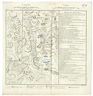
Rare-Antique Map-BATTLE OF KAISERSLAUTERN-GERMANY-Ehnlich-Gross-1808
Publication Date: 1808
Seller: Pictura Prints, Art & Books, Overasselt, Netherlands
Seller rating 5 out of 5 stars

Freiherr August Daniel von Gross (illustrator). 'TAF. III. SCHLACHT VON KAYSERSLAUTERN AM 28TEN UND 29TEN NVBR 1793 (.).'Original antique military map showing the Battle of Kaiserslautern (2830 November 1793) between a Coalition army under Charles William Ferdinand, Duke of Brunswick-Wolfenb�ttel and a Republican French army led by Lazare Hoche.Made by Ehnlich after Freiherr August Daniel von Gross.Engraving / etching on hand-laid (verge) paper.Sheet size: 33.7 x 35.5 cm (13.27 x 13.98 inch). Image size: 30.5 x 32 cm. (12.01 x 12.6 inch).BATTLE OF KAISERSLAUTERN-GERMANYPCO-A18-45BACKGROUND INFORMATIONFrom: 'Historisch-Militarischer Atlas zu des Freyherrn A.G. von Gross .'. , published in Amsterdam and Schleuen, Kunst- und Industrie-Comptoir in c.1808. This Atlas with 18 maps covers battles in various parts of Europe from 1792-1808 and served as a military handbook. Condition: very good, given age. Vertical fold as issued. General age-related toning and/or occasional minor defects from handling. Please study scan carefully.