Order Total (1 Item Items):
Shipping Destination:

Engraved Bartholomew (46 results)
Skip to main search results
Search filters
Product Type
- All Product Types
- Books (3)
- Magazines & Periodicals (No further results match this refinement)
- Comics (No further results match this refinement)
- Sheet Music (No further results match this refinement)
- Art, Prints & Posters (25)
- Photographs (No further results match this refinement)
- Maps (18)
- Manuscripts & Paper Collectibles (No further results match this refinement)
Condition Learn more
- New (No further results match this refinement)
- As New, Fine or Near Fine (No further results match this refinement)
- Very Good or Good (41)
- Fair or Poor (No further results match this refinement)
- As Described (5)
Binding
- All Bindings
- Hardcover (No further results match this refinement)
- Softcover (16)
Collectible Attributes
- First Edition (3)
- Signed (No further results match this refinement)
- Dust Jacket (No further results match this refinement)
- Seller-Supplied Images (40)
- Not Print on Demand (46)
Language (2)
Free Shipping
- Free Shipping to U.S.A. (No further results match this refinement)
Seller Location
Seller Rating
-
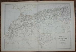
1884 Blackie's Map of Marocco, Algeria and Tunis
Published by Blackie & Son, London, Glasgow, Edinburgh and Dublin, 1884
Map
US$ 17.44
US$ 19.19 shipping
Ships from United Kingdom to U.S.A.Quantity: 1 available
Add to basketSoftcover. Condition: Very Good. Dust Jacket Condition: No Dust Jacket. Drawn and Engraved by J. Bartholomew (illustrator). Early Edition. Disbound map from the 1884 "Comprehensive Atlas & Geography of the World: Comprising an Extensive Series of Maps, a Description, Physical and Political, of all the Countries of the Earth; a Pronouncing Vocabulary of Geographical Names, and a Copious Index of Geographical Positions. Compiled and Engraved from the Most Authentic Sources, Under the Supervision of W. G. Blackie, PhD., F.S.A.Scot." Sheet number covers Single sheet with horizontal centre fold. Sheet is clean but slightly darkened at the edges. Map is drawn to a given scale with latitude and longitude lines, map is extensively labeled. Pastel shades have been used to denote countries and slightly darker shades have been used to denote boarders. Black and white engraved hatching shows landscape features. Size: 38x56cm. Item Type: Map. No dust jacket, as published. Single sheet map/chart which is suitable for framing. Illustrator: Drawn and Engraved by J. Bartholomew. Quantity Available: 1. Shipped Weight: under 1 kg. Pictures of this item not already displayed here available upon request. Inventory No: 45117104041. All our books are sent by tracked mail.
-
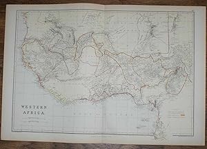
1884 Blackie's Map of Western Africa
Published by Blackie & Son, London, Glasgow, Edinburgh and Dublin, 1884
Map
US$ 17.44
US$ 19.19 shipping
Ships from United Kingdom to U.S.A.Quantity: 1 available
Add to basketSoftcover. Condition: Very Good. Dust Jacket Condition: No Dust Jacket. Drawn and Engraved by J. Bartholomew (illustrator). Early Edition. Disbound map from the 1884 "Comprehensive Atlas & Geography of the World: Comprising an Extensive Series of Maps, a Description, Physical and Political, of all the Countries of the Earth; a Pronouncing Vocabulary of Geographical Names, and a Copious Index of Geographical Positions. Compiled and Engraved from the Most Authentic Sources, Under the Supervision of W. G. Blackie, PhD., F.S.A.Scot." Sheet number covers Single sheet with horizontal centre fold. Sheet is clean but slightly darkened at the edges. Map is drawn to a given scale with latitude and longitude lines, map is extensively labeled. Pastel shades have been used to denote countries and slightly darker shades have been used to denote boarders. Black and white engraved hatching shows landscape features. Size: 38x56cm. Item Type: Map. No dust jacket, as published. Single sheet map/chart which is suitable for framing. Illustrator: Drawn and Engraved by J. Bartholomew. Quantity Available: 1. Shipped Weight: under 1 kg. Pictures of this item not already displayed here available upon request. Inventory No: 45117104040. All our books are sent by tracked mail.
-
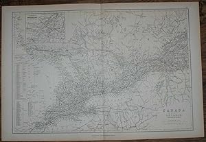
1884 Blackie's Map of Canada - The Province of Ontario and part of Quebec
Published by Blackie & Son, London, Glasgow, Edinburgh and Dublin, 1884
Map
US$ 18.54
US$ 19.19 shipping
Ships from United Kingdom to U.S.A.Quantity: 1 available
Add to basketSoftcover. Condition: Very Good. Dust Jacket Condition: No Dust Jacket. Drawn and Engraved by J. Bartholomew (illustrator). Early Edition. Disbound map from the 1884 "Comprehensive Atlas & Geography of the World: Comprising an Extensive Series of Maps, a Description, Physical and Political, of all the Countries of the Earth; a Pronouncing Vocabulary of Geographical Names, and a Copious Index of Geographical Positions. Compiled and Engraved from the Most Authentic Sources, Under the Supervision of W. G. Blackie, PhD., F.S.A.Scot." Sheet number covers Single sheet with horizontal centre fold. Sheet is clean but slightly darkened at the edges. Map is drawn to a given scale with latitude and longitude lines, map is extensively labeled. Pastel shades have been used to denote countries and slightly darker shades have been used to denote boarders. Black and white engraved hatching shows landscape features. Size: 38x56cm. Item Type: Map. No dust jacket, as published. Single sheet map/chart which is suitable for framing. Illustrator: Drawn and Engraved by J. Bartholomew. Quantity Available: 1. Shipped Weight: under 1 kg. Pictures of this item not already displayed here available upon request. Inventory No: 45117104036. All our books are sent by tracked mail.
-
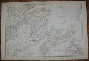
1884 Blackie's Map of Canada - The Provinces of Quebec, Nova Scotia, New Brunswick, Prince Edward Island and Newfoundland
Published by Blackie & Son, London, Glasgow, Edinburgh and Dublin, 1884
Map
US$ 18.54
US$ 19.19 shipping
Ships from United Kingdom to U.S.A.Quantity: 1 available
Add to basketSoftcover. Condition: Very Good. Dust Jacket Condition: No Dust Jacket. Drawn and Engraved by J. Bartholomew (illustrator). Early Edition. Disbound map from the 1884 "Comprehensive Atlas & Geography of the World: Comprising an Extensive Series of Maps, a Description, Physical and Political, of all the Countries of the Earth; a Pronouncing Vocabulary of Geographical Names, and a Copious Index of Geographical Positions. Compiled and Engraved from the Most Authentic Sources, Under the Supervision of W. G. Blackie, PhD., F.S.A.Scot." Single sheet with vertical centre fold. Sheet is clean but slightly darkened at the edges. Map is drawn to a given scale with latitude and longitude lines, map is extensively labeled. Pastel shades have been used to denote countries and slightly darker shades have been used to denote boarders. Black and white engraved hatching shows landscape features. Size: 38x56cm. Item Type: Map. No dust jacket, as published. Single sheet map/chart which is suitable for framing. Illustrator: Drawn and Engraved by J. Bartholomew. Quantity Available: 1. Shipped Weight: under 1 kg. Pictures of this item not already displayed here available upon request. Inventory No: 45117104037. All our books are sent by tracked mail.
-
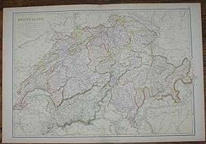
1884 Blackie's Map of Switzerland
Published by Blackie & Son, London, Glasgow, Edinburgh and Dublin, 1884
Map
US$ 19.62
US$ 19.19 shipping
Ships from United Kingdom to U.S.A.Quantity: 1 available
Add to basketSoftcover. Condition: Very Good. Dust Jacket Condition: No Dust Jacket. Drawn and Engraved by J. Bartholomew (illustrator). Early Edition. Disbound map from the 1884 "Comprehensive Atlas & Geography of the World: Comprising an Extensive Series of Maps, a Description, Physical and Political, of all the Countries of the Earth; a Pronouncing Vocabulary of Geographical Names, and a Copious Index of Geographical Positions. Compiled and Engraved from the Most Authentic Sources, Under the Supervision of W. G. Blackie, PhD., F.S.A.Scot." Sheet number covers Single sheet with horizontal centre fold. Sheet is clean but slightly darkened at the edges. Map is drawn to a given scale with latitude and longitude lines, map is extensively labeled. Pastel shades have been used to denote countries and slightly darker shades have been used to denote boarders. Black and white engraved hatching shows landscape features. Size: 38x56cm. Item Type: Map. No dust jacket, as published. Single sheet map/chart which is suitable for framing. Illustrator: Drawn and Engraved by J. Bartholomew. Quantity Available: 1. Shipped Weight: under 1 kg. Pictures of this item not already displayed here available upon request. Inventory No: 45117104018. All our books are sent by tracked mail.
-
1884 Blackie's Map of Central Europe, showing the Principal Railways and the Political Boundaries
Published by Blackie & Son, London, Glasgow, Edinburgh and Dublin, 1884
Map
US$ 19.62
US$ 19.19 shipping
Ships from United Kingdom to U.S.A.Quantity: 1 available
Add to basketSoftcover. Condition: Very Good. Dust Jacket Condition: No Dust Jacket. Drawn and Engraved by J. Bartholomew (illustrator). Early Edition. Disbound map from the 1884 "Comprehensive Atlas & Geography of the World: Comprising an Extensive Series of Maps, a Description, Physical and Political, of all the Countries of the Earth; a Pronouncing Vocabulary of Geographical Names, and a Copious Index of Geographical Positions. Compiled and Engraved from the Most Authentic Sources, Under the Supervision of W. G. Blackie, PhD., F.S.A.Scot." Sheet number covers Single sheet with horizontal centre fold. Sheet is clean but slightly darkened at the edges. Map is drawn to a given scale with latitude and longitude lines, map is extensively labeled. Pastel shades have been used to denote countries and slightly darker shades have been used to denote boarders. Black and white engraved hatching shows landscape features. Size: 38x56cm. Item Type: Map. No dust jacket, as published. Single sheet map/chart which is suitable for framing. Illustrator: Drawn and Engraved by J. Bartholomew. Quantity Available: 1. Shipped Weight: under 1 kg. Pictures of this item not already displayed here available upon request. Inventory No: 45117104021. All our books are sent by tracked mail.
-
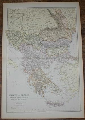
1884 Blackie's Map of Turkey, Greece, Roumania, Servia, Bulgaria, Bosnia & Montenegro
Published by Blackie & Son, London, Glasgow, Edinburgh and Dublin, 1884
Map
US$ 19.62
US$ 19.19 shipping
Ships from United Kingdom to U.S.A.Quantity: 1 available
Add to basketSoftcover. Condition: Very Good. Dust Jacket Condition: No Dust Jacket. Drawn and Engraved by J. Bartholomew (illustrator). Early Edition. Disbound map from the 1884 "Comprehensive Atlas & Geography of the World: Comprising an Extensive Series of Maps, a Description, Physical and Political, of all the Countries of the Earth; a Pronouncing Vocabulary of Geographical Names, and a Copious Index of Geographical Positions. Compiled and Engraved from the Most Authentic Sources, Under the Supervision of W. G. Blackie, PhD., F.S.A.Scot." Sheet number covers Single sheet with horizontal centre fold. Sheet is clean but slightly darkened at the edges. Map is drawn to a given scale with latitude and longitude lines, map is extensively labeled. Pastel shades have been used to denote countries and slightly darker shades have been used to denote boarders. Black and white engraved hatching shows landscape features. Size: 56x38cm. Item Type: Map. No dust jacket, as published. Single sheet map/chart which is suitable for framing. Illustrator: Drawn and Engraved by J. Bartholomew. Quantity Available: 1. Shipped Weight: under 1 kg. Pictures of this item not already displayed here available upon request. Inventory No: 45117104007. All our books are sent by tracked mail.
-
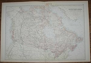
1884 Blackie's Map of British North America - The Dominion of Canada
Published by Blackie & Son, London, Glasgow, Edinburgh and Dublin, 1884
Map
US$ 21.81
US$ 19.19 shipping
Ships from United Kingdom to U.S.A.Quantity: 1 available
Add to basketSoftcover. Condition: Very Good. Dust Jacket Condition: No Dust Jacket. Drawn and Engraved by J. Bartholomew (illustrator). Early Edition. Disbound map from the 1884 "Comprehensive Atlas & Geography of the World: Comprising an Extensive Series of Maps, a Description, Physical and Political, of all the Countries of the Earth; a Pronouncing Vocabulary of Geographical Names, and a Copious Index of Geographical Positions. Compiled and Engraved from the Most Authentic Sources, Under the Supervision of W. G. Blackie, PhD., F.S.A.Scot." Sheet number covers Single sheet with horizontal centre fold. Sheet is clean but slightly darkened at the edges. Map is drawn to a given scale with latitude and longitude lines, map is extensively labeled. Pastel shades have been used to denote countries and slightly darker shades have been used to denote boarders. Black and white engraved hatching shows landscape features. Size: 38x56cm. Item Type: Map. No dust jacket, as published. Single sheet map/chart which is suitable for framing. Illustrator: Drawn and Engraved by J. Bartholomew. Quantity Available: 1. Shipped Weight: under 1 kg. Pictures of this item not already displayed here available upon request. Inventory No: 45117104038. All our books are sent by tracked mail.
-
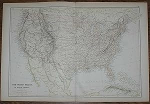
1884 Blackie's Map of The United States of North America
Published by Blackie & Son, London, Glasgow, Edinburgh and Dublin, 1884
Map
US$ 21.81
US$ 19.19 shipping
Ships from United Kingdom to U.S.A.Quantity: 1 available
Add to basketSoftcover. Condition: Very Good. Dust Jacket Condition: No Dust Jacket. Drawn and Engraved by J. Bartholomew (illustrator). Early Edition. Disbound map from the 1884 "Comprehensive Atlas & Geography of the World: Comprising an Extensive Series of Maps, a Description, Physical and Political, of all the Countries of the Earth; a Pronouncing Vocabulary of Geographical Names, and a Copious Index of Geographical Positions. Compiled and Engraved from the Most Authentic Sources, Under the Supervision of W. G. Blackie, PhD., F.S.A.Scot." Sheet number covers Single sheet with horizontal centre fold. Sheet is clean but slightly darkened at the edges. Map is drawn to a given scale with latitude and longitude lines, map is extensively labeled. Pastel shades have been used to denote countries and slightly darker shades have been used to denote boarders. Black and white engraved hatching shows landscape features. Size: 38x56cm. Item Type: Map. No dust jacket, as published. Single sheet map/chart which is suitable for framing. Illustrator: Drawn and Engraved by J. Bartholomew. Quantity Available: 1. Shipped Weight: under 1 kg. Pictures of this item not already displayed here available upon request. Inventory No: 45117104035. All our books are sent by tracked mail.
-
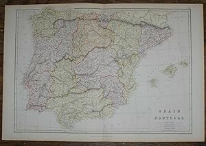
1884 Blackie's Map of Spain and Portugal
Published by Blackie & Son, London, Glasgow, Edinburgh and Dublin, 1884
Map
US$ 21.81
US$ 19.19 shipping
Ships from United Kingdom to U.S.A.Quantity: 1 available
Add to basketSoftcover. Condition: Very Good. Dust Jacket Condition: No Dust Jacket. Drawn and Engraved by J. Bartholomew (illustrator). Early Edition. Disbound map from the 1884 "Comprehensive Atlas & Geography of the World: Comprising an Extensive Series of Maps, a Description, Physical and Political, of all the Countries of the Earth; a Pronouncing Vocabulary of Geographical Names, and a Copious Index of Geographical Positions. Compiled and Engraved from the Most Authentic Sources, Under the Supervision of W. G. Blackie, PhD., F.S.A.Scot." Sheet number covers Single sheet with horizontal centre fold. Sheet is clean but slightly darkened at the edges. Map is drawn to a given scale with latitude and longitude lines, map is extensively labeled. Pastel shades have been used to denote countries and slightly darker shades have been used to denote boarders. Black and white engraved hatching shows landscape features. Size: 38x56cm. Item Type: Map. No dust jacket, as published. Single sheet map/chart which is suitable for framing. Illustrator: Drawn and Engraved by J. Bartholomew. Quantity Available: 1. Shipped Weight: under 1 kg. Pictures of this item not already displayed here available upon request. Inventory No: 45117104016. All our books are sent by tracked mail.
-
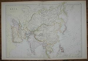
1884 Blackie's Map of Asia
Published by Blackie & Son, London, Glasgow, Edinburgh and Dublin, 1884
Map
US$ 23.99
US$ 19.19 shipping
Ships from United Kingdom to U.S.A.Quantity: 1 available
Add to basketSoftcover. Condition: Very Good. Dust Jacket Condition: No Dust Jacket. Drawn and Engraved by J. Bartholomew (illustrator). Early Edition. Disbound map from the 1884 "Comprehensive Atlas & Geography of the World: Comprising an Extensive Series of Maps, a Description, Physical and Political, of all the Countries of the Earth; a Pronouncing Vocabulary of Geographical Names, and a Copious Index of Geographical Positions. Compiled and Engraved from the Most Authentic Sources, Under the Supervision of W. G. Blackie, PhD., F.S.A.Scot." Sheet number covers Single sheet with horizontal centre fold. Sheet is clean but slightly darkened at the edges. Map is drawn to a given scale with latitude and longitude lines, map is extensively labeled. Pastel shades have been used to denote countries and slightly darker shades have been used to denote boarders. Black and white engraved hatching shows landscape features. Size: 38x56cm. Item Type: Map. No dust jacket, as published. Single sheet map/chart which is suitable for framing. Illustrator: Drawn and Engraved by J. Bartholomew. Quantity Available: 1. Shipped Weight: under 1 kg. Pictures of this item not already displayed here available upon request. Inventory No: 45117104015. All our books are sent by tracked mail.
-
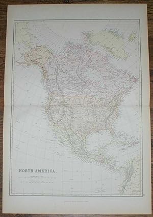
1884 Blackie's Map of North America
Published by Blackie & Son, London, Glasgow, Edinburgh and Dublin, 1884
Map
US$ 23.99
US$ 19.19 shipping
Ships from United Kingdom to U.S.A.Quantity: 1 available
Add to basketSoftcover. Condition: Very Good. Dust Jacket Condition: No Dust Jacket. Drawn and Engraved by J. Bartholomew (illustrator). Early Edition. Disbound map from the 1884 "Comprehensive Atlas & Geography of the World: Comprising an Extensive Series of Maps, a Description, Physical and Political, of all the Countries of the Earth; a Pronouncing Vocabulary of Geographical Names, and a Copious Index of Geographical Positions. Compiled and Engraved from the Most Authentic Sources, Under the Supervision of W. G. Blackie, PhD., F.S.A.Scot." Sheet number covers Single sheet with horizontal centre fold. Sheet is clean but slightly darkened at the edges. Map is drawn to a given scale with latitude and longitude lines, map is extensively labeled. Pastel shades have been used to denote countries and slightly darker shades have been used to denote boarders. Black and white engraved hatching shows landscape features. Size: 56x38cm. Item Type: Map. No dust jacket, as published. Single sheet map/chart which is suitable for framing. Illustrator: Drawn and Engraved by J. Bartholomew. Quantity Available: 1. Shipped Weight: under 1 kg. Pictures of this item not already displayed here available upon request. Inventory No: 45117104005. All our books are sent by tracked mail.
-
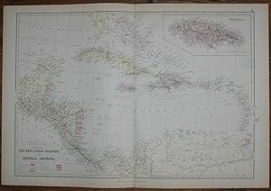
1884 Blackie's Map of The West India Islands and Central America
Published by Blackie & Son, London, Glasgow, Edinburgh and Dublin, 1884
Map
US$ 23.99
US$ 19.19 shipping
Ships from United Kingdom to U.S.A.Quantity: 1 available
Add to basketSoftcover. Condition: Very Good. Dust Jacket Condition: No Dust Jacket. Drawn and Engraved by J. Bartholomew (illustrator). Early Edition. Disbound map from the 1884 "Comprehensive Atlas & Geography of the World: Comprising an Extensive Series of Maps, a Description, Physical and Political, of all the Countries of the Earth; a Pronouncing Vocabulary of Geographical Names, and a Copious Index of Geographical Positions. Compiled and Engraved from the Most Authentic Sources, Under the Supervision of W. G. Blackie, PhD., F.S.A.Scot." Sheet number covers Single sheet with horizontal centre fold. Sheet is clean but slightly darkened at the edges. Map is drawn to a given scale with latitude and longitude lines, map is extensively labeled. Pastel shades have been used to denote countries and slightly darker shades have been used to denote boarders. Black and white engraved hatching shows landscape features. Size: 38x56cm. Item Type: Map. No dust jacket, as published. Single sheet map/chart which is suitable for framing. Illustrator: Drawn and Engraved by J. Bartholomew. Quantity Available: 1. Shipped Weight: under 1 kg. Pictures of this item not already displayed here available upon request. Inventory No: 45117104033. All our books are sent by tracked mail.
-
1884 Blackie's Map of The British Islands and the North Sea
Published by Blackie & Son, London, Glasgow, Edinburgh and Dublin, 1884
Map
US$ 25.08
US$ 19.19 shipping
Ships from United Kingdom to U.S.A.Quantity: 1 available
Add to basketSoftcover. Condition: Very Good. Dust Jacket Condition: No Dust Jacket. Drawn and Engraved by J. Bartholomew (illustrator). Early Edition. Disbound map from the 1884 "Comprehensive Atlas & Geography of the World: Comprising an Extensive Series of Maps, a Description, Physical and Political, of all the Countries of the Earth; a Pronouncing Vocabulary of Geographical Names, and a Copious Index of Geographical Positions. Compiled and Engraved from the Most Authentic Sources, Under the Supervision of W. G. Blackie, PhD., F.S.A.Scot." Sheet number covers Single sheet with horizontal centre fold. Sheet is clean but slightly darkened at the edges. Map is drawn to a given scale with latitude and longitude lines, map is extensively labeled. Pastel shades have been used to denote countries and slightly darker shades have been used to denote boarders. Black and white engraved hatching shows landscape features. Size: 38x56cm. Item Type: Map. No dust jacket, as published. Single sheet map/chart which is suitable for framing. Illustrator: Drawn and Engraved by J. Bartholomew. Quantity Available: 1. Shipped Weight: under 1 kg. Pictures of this item not already displayed here available upon request. Inventory No: 45117104024. All our books are sent by tracked mail.
-

St Bartholomew Massacre - a Fine Engraved Scene
Language: English
Publication Date: 1860
Seller: K Books Ltd ABA ILAB, York, YORKS, United Kingdom
Association Member: ABA ILAB PBFA
Seller rating 5 out of 5 stars

US$ 27.26
US$ 25.80 shipping
Ships from United Kingdom to U.S.A.Quantity: 1 available
Add to basketNo Binding. Condition: Very Good. A splendid engraved scene - mounted , matted and ready to frame. Circa 1860 - in very good condition. Mount size approx 12 x 8 inches. Shows a fine scene - St Bartholomew Massacre.
-

Birmingham
Published by Published by A. Fullarton & Co. [1860], London & Edinburgh, 1860
Seller: Keoghs Books, Skipton, United Kingdom
Association Member: PBFA
Seller rating 5 out of 5 stars
Map First Edition
US$ 27.26
US$ 37.05 shipping
Ships from United Kingdom to U.S.A.Quantity: 1 available
Add to basket, paper map folded at centre, hand-coloured in outline, scale of half a mile to an inch, upper left Smethwick, upper right Aston, lower left Harbourne, lower right Bordesley First Edition thus , lightly foxed around margins and a few patches to map, in good condition 35 x 26.5 cm Paperback ISBN:
-

The Channel Islands; General Map of the Islands, Alderney & The Casquets, Guernsey and Sercq, Jersey
Published by Published by A. Fullarton & Co [1860], London, 1860
Seller: Keoghs Books, Skipton, United Kingdom
Association Member: PBFA
Seller rating 5 out of 5 stars
Map First Edition
US$ 34.07
US$ 37.05 shipping
Ships from United Kingdom to U.S.A.Quantity: 1 available
Add to basket, 4 maps on one sheet, folded at centre, hand-coloured in outline, diferent scales for each of the 4 maps First Edition , some light spots at margins, maps clean, neat edge repair, in good+ condition 35 x 26.5 cm Paperback ISBN:
-
Original Antique Engraving Illustrating a Print of the Interior View of Stamford, with the Bridge in Lincolnshire. Engraved By B. Howlett and Drawn By J. C. Nattes, Titled and Dated 1804
Published by William Miller, London, 1804
Art / Print / Poster
US$ 65.42
US$ 25.08 shipping
Ships from United Kingdom to U.S.A.Quantity: 1 available
Add to basketNo Binding. Condition: Very Good. An original single antique engraving from a selection of views in the County of Lincoln by Bartholomew Howlett. This one illustrating the Interior view of Stamford, with the Bridge in Lincolnshire, engraved by B. Howlett and drawn J. C. Nattes. Titled and dated 1804. Illustration size 13 x 19cm. An original engraving. Fine condition.
-
Original Antique Engraving Illustrating a Print of This one illustrating Redbourne in Lincolnshire etched by S. Rawle, engraved by B. Howlett from the drawing by J. C. Nattes. Titled and Dated 1804
Published by William Miller, London, 1804
Art / Print / Poster
US$ 65.42
US$ 25.08 shipping
Ships from United Kingdom to U.S.A.Quantity: 1 available
Add to basketNo Binding. Condition: Very Good. An original single antique engraving from a selection of views in the County of Lincoln by Bartholomew Howlett. This one illustrating Redbourne, etched by S. Rawle, engraved by B. Howlett from the drawing by J. C. Nattes. Titled and dated 1804. Illustration size 13 x 19cm. An original engraving. Fine condition.
-
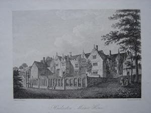
Original Antique Engraving Illustrating Harlaxton Manor House. Engraved By B. Howlett and Dated 1800.
Published by William Miller, London, 1813
Art / Print / Poster
US$ 65.42
US$ 25.08 shipping
Ships from United Kingdom to U.S.A.Quantity: 1 available
Add to basketNo Binding. Condition: Very Good. An original single antique engraving from a selection of views in the County of Lincoln by Bartholomew Howlett. This one illustrating Harlaxton Manor House, engraved by Bartholomew Howlett from the drawing by Jas.Bourne. Titled and dated 1800. Illustration size 13 x 19cm. An original engraving. Fine condition. Ready for framing.
-

Original Antique Engraving Illustrating Gate Burton. Engraved By B. Howlett and Dated 1798.
Published by William Miller, London, 1798
Art / Print / Poster
US$ 65.42
US$ 25.08 shipping
Ships from United Kingdom to U.S.A.Quantity: 1 available
Add to basketNo Binding. Condition: Very Good. An original single antique engraving from a selection of views in the County of Lincoln by Bartholomew Howlett. This one illustrating Gate Burton, engraved by Bartholomew Howlett from the drawing by J.C.Nattes. Titled and dated 1798. Illustration size 13 x 19cm. An original engraving. Fine condition. Ready for framing.
-
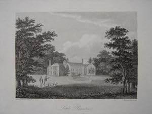
Original Antique Engraving Illustrating Little Paunton. Engraved By B. Howlett and Dated 1799.
Published by William Miller, London, 1813
Art / Print / Poster
US$ 65.42
US$ 25.08 shipping
Ships from United Kingdom to U.S.A.Quantity: 1 available
Add to basketNo Binding. Condition: Very Good. An original single antique engraving from a selection of views in the County of Lincoln by Bartholomew Howlett. This one illustrating Little Paunton, engraved by Bartholomew Howlett from the drawing by The Rev.Charles Turner. Titled and dated 1799. Illustration size 13 x 19cm. An original engraving. Fine condition.
-
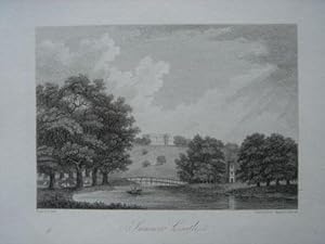
Original Antique Engraving Illustrating Summer Castle. Engraved By B. Howlett and Dated 1804.
Published by William Miller, London, 1804
Art / Print / Poster
US$ 65.42
US$ 25.08 shipping
Ships from United Kingdom to U.S.A.Quantity: 1 available
Add to basketNo Binding. Condition: Very Good. An original single antique engraving from a selection of views in the County of Lincoln by Bartholomew Howlett. This one illustrating Summer Castle, engraved by Bartholomew Howlett from the drawing by J.C. Nattes. Titled and dated 1804. Illustration size 13 x 19cm. An original engraving. Fine condition.
-
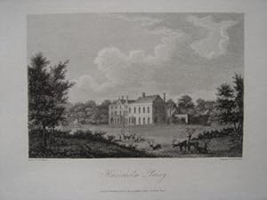
Original Antique Engraving Illustrating Haverholm Priory. Engraved By B. Howlett and Dated 1802.
Published by William Miller, London, 1813
Art / Print / Poster
US$ 65.42
US$ 25.08 shipping
Ships from United Kingdom to U.S.A.Quantity: 1 available
Add to basketNo Binding. Condition: Very Good. An original single antique engraving from a selection of views in the County of Lincoln by Bartholomew Howlett. This one illustrating Haverholm Priory, engraved by Bartholomew Howlett from the drawing by W. Brand. Titled and dated 1802. Illustration size 13 x 19cm. An original engraving. Fine condition. Ready for framing.
-
Original Antique Engraving Illustrating a Print of a South View of Stamford in Lincolnshire. Engraved By B. Howlett and Drawn By J. C. Nattes, Titled and Dated 1804
Published by William Miller, London, 1804
Art / Print / Poster
US$ 65.42
US$ 25.08 shipping
Ships from United Kingdom to U.S.A.Quantity: 1 available
Add to basketNo Binding. Condition: Very Good. An original single antique engraving from a selection of views in the County of Lincoln by Bartholomew Howlett. This one illustrating a South View of Stamford in Lincolnshire, engraved by B. Howlett and drawn J. C. Nattes. Titled and dated 1804. Illustration size 13 x 19cm. An original engraving. Fine condition.
-
Original Antique Engraving Illustrating a Print of Revesby Abbey in Lincolnshire. Engraved By B. Howlett, Drawn By T. Nash from a Sketch By William Brand, Esq, Titled and Dated 1803
Published by William Miller, London, 1803
Art / Print / Poster
US$ 65.42
US$ 25.08 shipping
Ships from United Kingdom to U.S.A.Quantity: 1 available
Add to basketNo Binding. Condition: Very Good. An original single antique engraving from a selection of views in the County of Lincoln by Bartholomew Howlett. This one illustrating Revesby Abbey, engraved by B. Howlett, drawn by T. Nash from a sketch by William Brand, Esq. Titled and dated 1803. Illustration size 13 x 19cm. An original engraving. Fine condition.
-
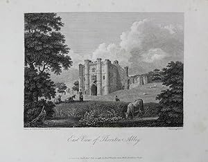
Original Antique Engraving Illustrating a Print of Thornton Abbey (East View) in Lincolnshire. Engraved By B. Howlett, Titled and Dated 1798
Published by William Miller, London, 1798
Art / Print / Poster
US$ 65.42
US$ 25.08 shipping
Ships from United Kingdom to U.S.A.Quantity: 1 available
Add to basketNo Binding. Condition: Very Good. An original single antique engraving from a selection of views in the County of Lincoln by Bartholomew Howlett. This one illustrating East View of Thornton Abbey, engraved by Bartholomew Howlett, drawn by T. Girtin from a sketch by Mr. Thomas Espin. Titled and dated 1798. Illustration size 13 x 19cm. An original engraving. Fine condition.
-
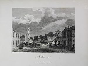
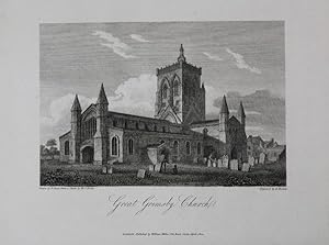
Original Antique Engraving Illustrating a Print of Great Grimsby Church in Lincolnshire. Engraved By B. Howlett, Titled and Dated 1802
Published by William Miller, London, 1802
Art / Print / Poster
US$ 65.42
US$ 25.08 shipping
Ships from United Kingdom to U.S.A.Quantity: 1 available
Add to basketNo Binding. Condition: Very Good. An original single antique engraving from a selection of views in the County of Lincoln by Bartholomew Howlett. This one illustrating Great Grimsby Church, engraved by Bartholomew Howlett from the drawing by F. Nash, from a sketch by Mr. J. Espin. Titled and dated 1802. Illustration size 13 x 19cm. An original engraving. Fine condition.
-
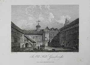
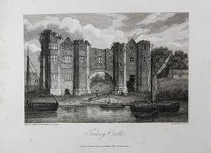
Original Antique Engraving Illustrating a Print of Torksey Castle in Lincolnshire. Engraved By B. Howlett, Titled and Dated 1802
Published by William Miller, London, 1802
Art / Print / Poster
US$ 65.42
US$ 25.08 shipping
Ships from United Kingdom to U.S.A.Quantity: 1 available
Add to basketNo Binding. Condition: Very Good. An original single antique engraving from a selection of views in the County of Lincoln by Bartholomew Howlett. This one illustrating Torksey Castle, engraved by Bartholomew Howlett from the drawing by J. Buckler, from a sketch by Mr. T. Espin. Titled and dated 1802. Illustration size 13 x 19cm. An original engraving. Fine condition.
-
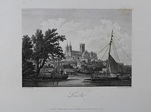
Original Antique Engraving Illustrating a View of Lincoln. Engraved By B. Howlett and Dated 1797
Published by William Miller, London, 1797
Art / Print / Poster
US$ 65.42
US$ 25.08 shipping
Ships from United Kingdom to U.S.A.Quantity: 1 available
Add to basketNo Binding. Condition: Very Good. An original single antique engraving from a selection of views in the County of Lincoln by Bartholomew Howlett. This one illustrating a view of Lincoln, engraved by Bartholomew Howlett from the drawing by T. Girton. Titled and dated 1797. Illustration size 13 x 19cm. An original engraving. Fine condition.