Order Total (1 Item Items):
Shipping Destination:

Enouy (5 results)
Author:
enouy
Refine with Advanced Search
Skip to main search results
Search filters
Product Type
- All Product Types
- Books (4)
- Magazines & Periodicals (No further results match this refinement)
- Comics (No further results match this refinement)
- Sheet Music (No further results match this refinement)
- Art, Prints & Posters (No further results match this refinement)
- Photographs (No further results match this refinement)
- Maps (1)
- Manuscripts & Paper Collectibles (No further results match this refinement)
Condition Learn more
- New (No further results match this refinement)
- As New, Fine or Near Fine (No further results match this refinement)
- Very Good or Good (2)
- Fair or Poor (No further results match this refinement)
- As Described (3)
Binding
- All Bindings
- Hardcover (1)
- Softcover (No further results match this refinement)
Collectible Attributes
- First Edition (No further results match this refinement)
- Signed (1)
- Dust Jacket (No further results match this refinement)
- Seller-Supplied Images (4)
- Not Print on Demand (5)
Language (1)
Price
- Any Price
- Under US$ 25 (No further results match this refinement)
- US$ 25 to US$ 50 (No further results match this refinement)
- Over US$ 50
Free Shipping
Seller Location
Seller Rating
-
A New Map of England and Wales Compiled From the Actual Surveys of the Counties
Published by Laurie and Whittle, 1811
Seller: Morning Mist Books and Maps, Cirencester, United Kingdom
Seller rating 5 out of 5 stars

Map
US$ 69.13
US$ 60.40 shipping
Ships from United Kingdom to U.S.A.Quantity: 1 available
Add to basketNo Binding. Condition: Good. 3rd Edition. 3rd Ed. Folding map rebacked with archival paper, as a result a little stiff on the folds. No slipcase. A couple of small tears to folds. General dust-marking and spotting. Marked and spotted to reverse. Slight wear to edges. Counties coloured in outline. Some basic hachuring in Wales and Dartmoor only. Turnpikes, Rivers and Canals marked. Published by Laurie and Whittle, 3rd Ed. Jan 1st 1811. 52cm by 67cm approx. Similar in style to Cary. More details available on request. (319UbDnon304).
-

Revolving firearms. being British Patent number: 1359 published: 14 June 1855
Published by London Eyre and Spottiswood published at the Great Seal Patent Office C, 1855
US$ 138.25
US$ 5.50 shipping
Ships from United Kingdom to U.S.A.Quantity: 1 available
Add to basketNo Binding. Condition: Good. First Edition. Original Printed patent disbound with printed front blue wrapper present but not the back wrapper (both often lacking in early patents) About 27cm by 18 cm some wear and tear due to the disbinding.
-
The United Kingdom of Great Britain & Ireland, with the adjacent parts of the Continent, from Amsterdam to Paris and Brest, compiled from a variety of the most authentic materials.
Seller: Antiquariaat Schierenberg, Amsterdam, Netherlands
Seller rating 4 out of 5 stars

London, Samuel Leigh, 1818. Large, folded, coloured map (62.7 x 75.3 cm) of Great Britain and Ireland, and the continental coasts of the Channel and North Sea. In original reddish paper-covered boards, with printed label mounted. = Large folding hand-coloured engraved map, by Joseph Enouy, and engraved by S. I. Neele & G. Neele. The geographer and cartographer Joseph Enouy is also known for his maps of Ireland, Africa and the Middle East. This detailed map includes the United Kingdom and Ireland in their entirety, as well as the northern parts of Brittany, Normandy, northwestern France and the Netherlands (here, Belgium and the Netherlands still forming one country). Provenance: signature of "Le Comte Andre de Turenne". Some light rubbing to boards, otherwise fine; the map in pristine condition. Extremely rare. Not in the British Museum Catalogue of Printed Maps, Charts and Plans.
-
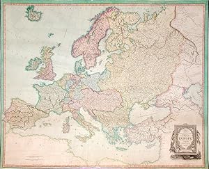
The Continent and Islands of Europe, from the best Foreign Surveys Etc
Published by London: Richard H. Laurie, 12th May, 1822., 1822
Seller: Arader Galleries - AraderNYC, New York, NY, U.S.A.
Seller rating 5 out of 5 stars
Signed
4 sheets joined, float-mounted and framed (47 x 58 6/8 inches; framed size: 54 x 65 4/8 inches). Magnificent engraved wall map of Europe laid down on cartographical linen and trimmed with silk, with exceptionally fine original hand-colour in full, the title within an elaborate allegorical cartouche lower right (a little browned along the bottom edge). THE FIRST CONFEDERATION OF EUROPE A superb example of Enouy's rare wall map of Europe, "the divisions according to the Treaties of 1815, other additions to 1822". This fine, detailed and beautiful wall-map shows Europe as it emerged from years of war with France. The Treaty of Paris was signed on the 20th of November 1815 following the decisive defeat of Napoleon Bonaparte at the Battle of Waterloo, and his subsequent and second abdication. In February of 1815, Napoleon had escaped from his exile on Elba, and by 20th March had re-entered Paris, beginning the Hundred Days of his restored rule. King Louis XVIII, who had fled France when Napoleon arrived in Paris, took the throne for a second time on 8 July. Although France's boundaries have been reduced to their pre-1790 positions, and heavy indemnities were imposed, a general desire amongst the coalition forces to see the Bourbon dynasty restored to power prevented the reparations from being harsher than they were. The treaty was signed for Great Britain by Lord Castlereagh and the Duke of Wellington and by the duc de Richelieu for France; parallel treaties with France were signed by Austria, Russia, and Prussia, forming in effect the first confederation of Europe. Laurie & Whittle was one of the foremost British cartographic firms of the late 18th and early 19th centuries. As the successors to Sayer & Bennett, who published Thomas Jefferys' groundbreaking "American Atlas," Laurie & Whittle became heirs to a legacy of international cartographic excellence and predominance. Signed by Author(s).
-
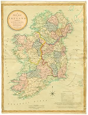
Antique Map-KINGDOM OF IRELAND-Enouy-Whittle-1808
Publication Date: 1808
Seller: Pictura Prints, Art & Books, Overasselt, Netherlands
Seller rating 5 out of 5 stars
Joseph Enouy (illustrator). 'A NEW MAP OF IRELAND.'This hand coloured print shows the map of the kingdom of Ireland with 4 provinces: Ulster, Munster, Connaught and Leinster. These are divided in counties.Made by an anonymous engraver after Joseph Enouy.Medium: engraving / hand coloured on hand laid (verge) paper.Sheet size: 51 x 66.5 cm (20.08 x 26.18 inch). Image size: 49.5 x 63.5 cm. (19.49 x 25 inch).MAP-KINGDOM OF IRELAND-EUROPE | RBOS-T33-LARGEBACKGROUND INFORMATIONThis attractive print was published in "A New and Elegant Imperial Sheet Atlas" published by Robert Laurie and James Whittle, London 1808.Biography artist: Joseph Enouy was a geographer. Condition: fair, given age. Brownish paper. Fold as published. Fold horizontal. Tears in margins old and new restored. One larger tear in lower right corner. Corners below and right margin paper loss. Smudges reverse. General age-related toning and/or occasional minor defects from handling. Please study scan carefully.