

Order Total (1 Item Items):
Shipping Destination:

Ensigns (7 results)
Author:
ensigns
Refine with Advanced Search
Skip to main search results
Search filters
Product Type
- All Product Types
- Books (4)
- Magazines & Periodicals (No further results match this refinement)
- Comics (No further results match this refinement)
- Sheet Music (No further results match this refinement)
- Art, Prints & Posters (No further results match this refinement)
- Photographs (No further results match this refinement)
- Maps (3)
- Manuscripts & Paper Collectibles (No further results match this refinement)
Condition Learn more
- New (No further results match this refinement)
- As New, Fine or Near Fine (1)
- Very Good or Good (No further results match this refinement)
- Fair or Poor (No further results match this refinement)
- As Described (6)
Binding
- All Bindings
- Hardcover (No further results match this refinement)
- Softcover (1)
Collectible Attributes
- First Edition (No further results match this refinement)
- Signed (1)
- Dust Jacket (No further results match this refinement)
- Seller-Supplied Images (7)
- Not Print on Demand (7)
Language (1)
Price
- Any Price
- Under US$ 25 (No further results match this refinement)
- US$ 25 to US$ 50
- Over US$ 50
Free Shipping
- Free Shipping to U.S.A. (No further results match this refinement)
Seller Location
Seller Rating
-
![Seller image for Anthology of modern Japanese poets [Chicago review, vol. 25, no.2] [Kenji Miyazawa, Mutsuo Takahashi, Taeko Tomioka, Minoru Yoshioka, Junzaburo Nishiwaki, Saburo Kuroda, Makoto Ooka, Shuzo Takiguchi, Yoshiro Ishihara, Ryusei Hasegawa, Nobuo Ayukawa, Masao Nakagiri, Rin Ishigaki, Ryuichi Tamura, Joy Kogawa] for sale by Joseph Valles - Books](https://pictures.abebooks.com/inventory/md/md32283580846.jpg)
Anthology of modern Japanese poets [Chicago review, vol. 25, no.2] [Kenji Miyazawa, Mutsuo Takahashi, Taeko Tomioka, Minoru Yoshioka, Junzaburo Nishiwaki, Saburo Kuroda, Makoto Ooka, Shuzo Takiguchi, Yoshiro Ishihara, Ryusei Hasegawa, Nobuo Ayukawa, Masao Nakagiri, Rin Ishigaki, Ryuichi Tamura, Joy Kogawa]
Published by University of Chicago Press, Chicago, 1973, 1973
Seller: Joseph Valles - Books, Stockbridge, GA, U.S.A.
Seller rating 5 out of 5 stars

Soft cover. Condition: Fine. 146 pages : illustrations, portraits ; 23 cm ; stiff paper wrappers ; Contents: Kenji Miyazawa -- Mutsuo Takahashi -- Taeko Tomioka -- Minoru Yoshioka -- Junzaburo Nishiwaki -- Saburo Kuroda -- Makoto Ooka -- Shuzo Takiguchi -- Yoshiro Ishihara -- Ryusei Hasegawa -- Nobuo Ayukawa -- Masao Nakagiri -- Rin Ishigaki -- Ryuichi Tamura --Joy Kogawa ; FINE. Book.
-
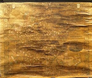
Map of the United States from the Latest Authorities
Published by New York, New York, 1848
Seller: High Ridge Books, Inc. - ABAA, South Deerfield, MA, U.S.A.
Association Member: ABAA ESA ILAB SNEAB
Seller rating 5 out of 5 stars
Generally fair condition, minor water stain at right. Needs restoration. Original top rod, lacks bottom stick, linen backed. Severe age toning. Colors oxidized. Shows only the eastern portion of the United States, with an inset of Oregon Territory at the top and a large map of Texas at the bottom right. There is also a small inset map of the southern half of Florida. Drawn & Engraved by William S. Barnard. A very attractive map, fully colored by county, with a decorative border showing the states and territories with their sizes and populations. In spite of its current unaestetic appearance, this is a quite rare map with its large inset map of Texas.
-
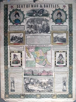
Seat of War & Battles
Published by New York, New York, 1847
Seller: High Ridge Books, Inc. - ABAA, South Deerfield, MA, U.S.A.
Association Member: ABAA ESA ILAB SNEAB
Seller rating 5 out of 5 stars
Patriotic broadside issued during the Mexican War, with a small map of the seat of war, portraits of Generals Scott and Taylor of the U.S., Santa Anna and General Ampudia of the Mexican Army. 4 battle views. fine condition, with one small tear in the top margin, not affecting the printed part of the broadside.
-
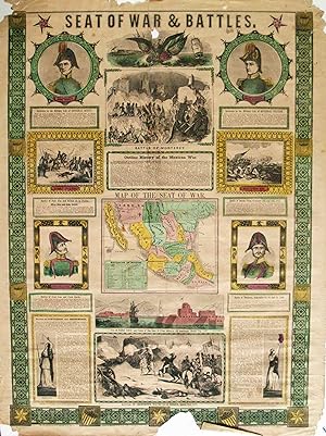
Seat of War & Battles
Published by New York, New York, 1847
Seller: High Ridge Books, Inc. - ABAA, South Deerfield, MA, U.S.A.
Association Member: ABAA ESA ILAB SNEAB
Seller rating 5 out of 5 stars
Patriotic broadside issued during the Mexican War, with a small map of the seat of war, portraits of Generals Scott and Taylor of the U.S., Santa Anna and General Ampudia of the Mexican Army. 4 battle views. Damaged at bottom border near center, with a small wedge out. The damage does not extend beyond the border. Mild damage at top corners, tear repaired near center with no loss.
-

Carte des Pavillons Accompagnee D' Observatioons Pour En Faire Comprendre le Blazon et les Differentes Devises Aussy bien que d'une Table Alphabetique Pour les Trouver Facilement.
Publication Date: 1720
Seller: Geographicus Rare Antique Maps, Brooklyn, NY, U.S.A.
Association Member: ABAA ESA ILAB
Seller rating 4 out of 5 stars

Map
Very good. Marginal mend upper left. Light wear at folds and general toning. Size 19.25 x 23 Inches. This 1720 Chatelain flag chart illustrates the world's flags during The War of the Spanish Succession (1701 - 1714) and the Great Northern War (1700 - 1720). A Closer Look The image displays 88 beautifully engraved and colored flags, primarily of European nations. In several cases, more than one flag is illustrated. For example, the French flags include the Royal Flag, the Admiral's flag, the flag of the Merchant Marine, and the flag of the Estates General. Four Ottoman flags appear, not counting the specific flags of Algeria and Tripoli. England is represented by six flags, not counting two for Scotland and one further for Ireland. This chart features several other rarely seen flags: in the lower row, the Dragon Ensign of China stands out. It appears as a great whirlpool surrounded by eight decorations. This is most likely based upon an image of the Chinese flag appearing in Carel Allard's 1705 Dutch flag book Niewe Hollandse Scheepsbouw . In fact, it is a misinterpretation of the Qing flag, a dragon on a yellow field with eight banners. Other flags of interest include Pope's banner, a curious Portuguese flag bearing a priest, the flags of various trading companies, the Flag of the Tartars (dragon), and the arm and saber banner of Poland. Courland (Kurzeme, the western part of Latvia) sports both a national banner and a naval flag featuring a black crab on a field of red. In addition to the actual flags depicted on the sheet, Chatelain provides a primer for understanding a flag's heraldic terminology in general and supplies the reader with an alphabetical table to aid in the location of specific flags on the sheet. Publication History and Census This sheet was printed in the last of the seven volumes of Chatelain's Atlas Historique , a monumental work published over the course of some 15 years - the first volume was completed in 1705, the seventh in 1720. Though this sheet does not appear separately in OCLC, the atlas is well represented in institutional collections.
-
Map of the City of New York, with the Adjacent Cities of Brooklyn and Jersey City, and the Village of Williamsburg.
Publication Date: 1848
Seller: Geographicus Rare Antique Maps, Brooklyn, NY, U.S.A.
Association Member: ABAA ESA ILAB
Seller rating 4 out of 5 stars
Map Signed
Very good. Light wear along original fold lines. Light soiling. Slight loss at a few fold intersections and an area of loss below 'Thayer' in the title. Accompanied by original binder. Size 16.75 x 20.75 Inches. This is a striking 1848 Ensigns and Thayer pocket map of New York City. It illustrates the city just as massive redistricting, leveling, and gridding were beginning to push urbanization into central and upper Manhattan. A Closer Look Coverage embraces Manhattan from 32nd Street south to the Battery and Brooklyn from the Navy Yard to Sackett Street along with part of Williamsburg. Part of Governor's Island appears along the left border. City wards are numbered and outlined. Streets are labeled throughout with red highlighting omnibus routes. The Harlem Railroad is illustrated running up the Bowery and Fourth Avenue. Piers are identified along the rivers, as well as ferry routes across the East River to Brooklyn and Williamsburg. The original site of Columbia College near Park Place is labeled. Two insets occupy the upper left. The smaller focuses on Jersey City, projecting new streets to be built on future landfills. The second inset illustrates northern Manhattan from 41st Street to the Harlem River. The Croton Aqueduct is prominently depicted, with the Receiving and Distributing Reservoirs labeled. Yorkville, Bloomingdale, Manhattanville, and Haerlem appear, as do Fort Washington and Fort Tryon. Publication History and Census This map was drawn and engraved by John Atwood and published by Ensign and Thayer in 1848. While at least three examples of this edition of this map are cataloged in OCLC, only one, the New York Public Library example, represents the 1848 edition. Below the map in the lower left margin, the copyright notice states, 'Entered according to Act of Congress in the year 1844 by Humphrey Phelps in the Clerk's Office of the District Court of the Southern District of New York'. Three signatures appear inside the binder. The first is Henry Baxter and is dated February 2, 1849. The second is Fred Frankhauser of 714 Pennsylvania Avenue in New Brighton, Pennsylvania, dated January 7, 1946. Fred Frankhauser signed the binder a second time near the top above Baxter's signature. We have been unable to trace either of these individuals. References: OCLC 46396162. New York Public Library Map Div. 01-1823. Haskell, D., Manhattan Maps A Co-operative List, 873 (1849). Signed by Author(s).
-

Map of New England.
Publication Date: 1847
Seller: Geographicus Rare Antique Maps, Brooklyn, NY, U.S.A.
Association Member: ABAA ESA ILAB
Seller rating 4 out of 5 stars
Map
Good. Full professional restoration. Light cracking. Size 31.5 x 26 Inches. This is an 1847 Ensigns and Thayer map of New England: Connecticut, Rhode Island, Massachusetts, Vermont, New Hampshire, and Maine. John Hancock and the Boston Tea Party An elaborate title cartouche, situated in the lower right, bears an engraving of the early American statesman John Hancock (1737 - 1793), along with his famous signature. The scene surrounding Hancock's portrait depicts the Boston Tea Party, an event with which Hancock is associated but in which he did not participate. The engraving illustrates the Beaver , a whaler and one of the last ships bearing tea to arrive in Boston. On the night of December 16, 1773, colonists dressed as Indians boarded the ships and dumped over 92,000 pounds of tea into the harbor. One of these ships was the Beaver . The title cartouche and the elaborate border work were engraved by Lossing and Barritt, an engraving firm based in New York City. Publication History and Census This map was published by Ensigns and Thayer of New York City in 1847. We note eight cataloged examples in OCLC which are part of the collections at Yale University, the Connecticut Historical Society, the Connecticut State Library, Brown University, Harvard University, the Peabody Essex Museum, the Buffalo and Erie County Public Library, and Duke University. References: OCLC 22694017.


