Order Total (1 Item Items):
Shipping Destination:

Ferry Hypolite (7 results)
Skip to main search results
Search filters
Product Type
- All Product Types
- Books (7)
- Magazines & Periodicals (No further results match this refinement)
- Comics (No further results match this refinement)
- Sheet Music (No further results match this refinement)
- Art, Prints & Posters (No further results match this refinement)
- Photographs (No further results match this refinement)
- Maps (No further results match this refinement)
- Manuscripts & Paper Collectibles (No further results match this refinement)
Condition Learn more
- New (No further results match this refinement)
- As New, Fine or Near Fine (No further results match this refinement)
- Very Good or Good (1)
- Fair or Poor (1)
- As Described (5)
Binding
- All Bindings
- Hardcover (5)
- Softcover (No further results match this refinement)
Collectible Attributes
- First Edition (3)
- Signed (1)
- Dust Jacket (No further results match this refinement)
- Seller-Supplied Images (5)
- Not Print on Demand (7)
Language (1)
Price
- Any Price
- Under US$ 25 (No further results match this refinement)
- US$ 25 to US$ 50 (No further results match this refinement)
- Over US$ 50
Free Shipping
Seller Location
Seller Rating
-
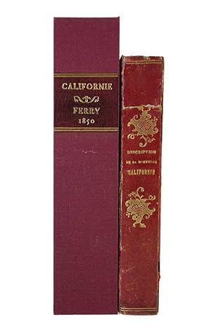
Description de la Nouvelle Californie Geographique, Politique et Morale [bound with]Voyage en Californie description de son sol, de son climat, de ses mines d'or. First editions
Published by Paris, : L. Maison, Editeur des Guides Richard; Arthus Bertrand, circa 1849-50., 1850
Seller: Wittenborn Art Books, San Francisco, CA, U.S.A.
Seller rating 5 out of 5 stars

Condition: Good. 12mo. 10.8 x 17cm. Quarter shagreen and marbled boards.Ferry: 386pp; 7 plates and maps, lacing the large folding map."The most complete and extensive work descriptive of California published in France at this time" (Cowan I). The views include possibly the first depiction of the big trees of California (see Howell 50) and a view of Sutter's Fort. Cowan I, p 84; Cowan II, p 207; Howes F101; Kurutz 236a; Pilling 1282; Sabin 24198; Vail Gold Fever p 19; Wheat Gold Region 155 & 156 (maps).Bryant: 272pp. folding maps by Duflot de Mofras.Sabin no. 8805.1/ FERRY (Hypolite). Description de la Nouvelle Californie g�ographique, politique et morale (); Paris, L. Maison, 1850. 7 planches ou cartes en hors-texte (sur 8). Sans la grande carte d�pliante.2/ BRYANT (Ed.). Voyage en Californie. Description de son sol, de son climat, de ses mines d'or. Paris, Artus Bertrand, s.d. [1849]. Exemplaire bien complet de la grande carte d�pliante.Expertise by Amaury BONNETAIN.bookplage of Baron de La Roche Lacarelle.
-
[California Gold Rush] DESCRIPTION DE LA NOUVELLE CALIFORNIE: GEOGRAPHIQUE, POLITIQUE ET MORALE. . .
Published by L. Maison, Paris, 1850
Seller: Michael Pyron, Bookseller, ABAA, Conshohocken, PA, U.S.A.
Association Member: ABAA ILAB IOBA
Seller rating 5 out of 5 stars
Half Leather. Condition: Very Good binding. 12mo. [4], 386 pp., frontis, maps, plates. Backed in maroon calf with marbled paper over boards. Spine ends and corners lightly worn; light to moderate foxing to the contents. Large folding map of western United States, "Carte de la Nouvelle Californie Dressee . . . 1850," with "Deuxieme Edition" printed at the top margin. There is some early reinforcement to the verso of some of the folds, map is a bit foxed. In addition to the large folding frontispiece map there are 4 engraved views including San Francisco, Fort Sutter, the redwood forest, and Pyramid Lake; as well as 3 additional full page mapsMonterey Bay, Panama, and Tierra del Fuego. Cowan calls this "the most complete and extensive work descriptive of California published in France at this time" (qtd. in Kurutz). An uncommon history and map of California in the early years of the Gold Rush. Text in French. Howes F-101; Kurutz 236a; Sabin 24198; Wheat, Books 75; Wheat, Maps 155.
-
Description de la Nouvelle Californie Geographique, Politique et Morale: contenant l'historique de la d�couverte de cette contr�e. Un pr�cis des �v�nements politiques qui s'y sont accomplis. Des renseignements d�taill�s sur sa topographie, son climat, ses productions min�rales, v�g�tales et animales. Des notions sur la min�rologie, la m�tallurgie et la g�ologie. Le caract�re, les moeurs, usages, co�tumes de ses habitants. La description de ses baies, ports, villes, missions, villages. Des instructions nautiques sur ses baies et ses ports. Le tarif des douanes en Californie. Des renseignements g�n�raux concernant les routes qui conduisent en Californie, les lieux de passage, description de Chagres, Panama, du cap Horn et de la Terre-de-Feu, etc. etc. Par Hypolite Ferry, Membre de la Soci�t� de g�ographie de Paris. Avec une grande carte de la nouvelle Californie. Des cartes particuli�res des baies de Monterey et de San-Francisco. De L'Isthme de Panama. Du cap Horn et du D�troit de Magell
Published by L. Maison, Editeur des Guides Richard, Paris, 1850
Seller: Heritage Book Shop, ABAA, Beverly Hills, CA, U.S.A.
Seller rating 5 out of 5 stars
First Edition
First Edition. contenant l'historique de la decouverte de cette contree. Un precis des evenements politiques qui s'y sont accomplis. Des renseignements detailles sur sa topographie, son climat, ses productions minerales, vegetales et animales. Des notions sur la minerologie, la metallurgie et la geologie. Le caractere, les moeurs, usages, coutumes de ses habitants. La description de ses baies, ports, villes, missions, villages. Des instructions nautiques sur ses baies et ses ports. Le tarif des douanes en Californie. Des renseignements generaux concernant les routes qui conduisent en Californie, les lieux de passage, description de Chagres, Panama, du cap Horn et de la Terre-de-Feu, etc. etc. Par Hypolite Ferry, Membre de la Societe de geographie de Paris. Avec une grande carte de la nouvelle Californie. Des cartes particulieres des baies de Monterey et de San-Francisco. De L'Isthme de Panama. Du cap Horn et du Detroit de Magellan. Et plusieurs vues interessantes de la Californie. Paris: L. Maison, Editeur des Guides Richard, 1850. Second edition, and the exact same as the first edition of the same year, with the exception of the folding map stating second edition. Second edition is not stated on the book, only the map. Octavo (6 7/8 x 4 1/2 inches; 175 x 115 mm). [4], [1]-386 pp. With large frontispiece folding map, three engraved maps and four engraved plates. Bound with the half-title. Contemporary quarter red morocco over pebbled boards. Spine stamped and lettered in gilt. Edges speckled blue. Boards edges rubbed. Outer hinges cracked but holding. Spine with a crack across the upper top portion. With mostly light foxing throughout. Two leaves with minor closed tears, with no loss of text. Large folding map with some minor closed tears and foxing. Previous owner Daniel G. Volkmann, Jr. bookplate on front pastedown. Other small bookplate on front pastedown as well. Overall a very nice copy. Housed in a custom cloth clamshell. The most complete and extensive work descriptive of California published in France at this time" (Cowan I). The views include possibly the first depiction of the big trees of California (see Howell 50) and a view of Sutter's Fort. Cowan, 84, 207. Howes F101. Sabin 24198. HBS 67393. $2,500.
-

Description de la Nouvelle Californie: Geographique, Politique et Morale.
Published by Paris: L. Maison, 1850., 1850
Seller: Arader Galleries - AraderNYC, New York, NY, U.S.A.
Seller rating 5 out of 5 stars
First Edition
Hardcover. 1st Edition. 8vo., (6 5/8 x 4 2/8 inches). Half-title (light intermittent spotting throughout). Four engraved views, three single leaf engraved maps "Carte particuliere des Baies de Monterey et de San Francisco", "Carte topographique d'une partie de l'Isthme de Panama comprenant le Bassin de la Riviere de Chagres et la Route de Chagres a Panama", "Carte d'une partie de L'Amerique Meridionale comprenant le Cap Horn et le Detroit de Magellan", and a large folding map ". de la Nouv.le Californie" (expertly repaired at folds and edge nearest the gutter). Near contemporary half brown morocco gilt marbled boards (extremities just touched). "the most complete and extensive work on California published in France at the time" Hill First edition, second issue, the large folding map of "Nouvelle Californie" with "Deuxieme Edition" printed along the top margin. With chapters on the gold regions and how to mine, Baja and Alta California, and New Helvetia. The plates are of Pyramid Lake, Sutter's Fort, giant sequoias, and San Francisco. Cowan p.207; Hill 598; Howes F201; Kurutz 236a; Sabin 24198; Wheat, Gold Region, 155 & 156. Catalogued by Kate Hunter.
-
La California Descrizione Geografica, Politica e Morale che Contiene la storia Della scoperta Di questa Terra. Quadro degli Avvenimenti politici Che Vi Si Effettuarno. Dettagli Sulla Sua topografia, Sul Clima, e Sulle Produzioni minerali, Vegetabili.
Published by Venice: Dalla Tipografia Fontana, 1851, 1851
Seller: Arader Galleries - AraderNYC, New York, NY, U.S.A.
Seller rating 5 out of 5 stars
Signed
Hardcover. 8vo. 324, (2) (plate list), 325-340 pp. (pages 3/4 misnumbered 4/3; seperately inserted index leaf usually found at end bound between pages 324/325), title and text printed within ornamental border, 12 engraved plates of views (each within ornamental border). Bound in contemporary three quarter smooth black Venetian calf over rose and brown mottled boards, spine filt decorated and ruled, edges mottled blue. Head of spine slightly chipped, corners and edges binding rubbed, mild worming to blank gutters, otherwise fine, interior bright and beautifull. Rare. Any prospective emigrant from the Mediterranean area perusing the illustrations in this guide while considering joining the Gold Rush in 1851 surely would have concluded that the California landscape would be very much like home. Never has Mission Dolores looked so grandiose in its makeover as the monumental Gates of Mycenae with three persons lounging in front, one wearing a turban and smoking a very long pipe. Perhaps the most unfathomable plate is Sotterranei nell'Indostan, an attempt to show California Native Americans. Apparently the natives have abandoned their humble sweat lodge, for they are shown ensconced in a vast Romanesque structure with barrel-vaulted ceiling. Gone, too, is their tribal garb, which has been discarded in favor of European peasant clothing. Charming though the images may be they lack documentary clout. Perhaps the lesson gleaned from this guide is that with a little ingenuity, European publishers might well profit from the Gold Rush. Although, there was a long European tradition of depicting New World features and people through the Old World lens, one is somewhat shocked to see the technique apllied so blatantly and crudely in this editition at this late date. Plates (some signed by Italian engraver G. Bernasconi): Rio Colorado, La Valle del Sacramento, Monti della California, Il lago Salato, Il forte Sutter, Miniere d'Oro, Miniere de Plombo, S. Francisco, Contorni de Monterey, Missione de S. Francisco de Assisi, Sotterranei nell'Indostan, and La Sierra-Morena. Signed by Author(s).
-

Description De La Nouvelle Californie
Published by L. Maison, Paris, 1850
Seller: Back of Beyond Books, Moab, UT, U.S.A.
Association Member: RMABA
Seller rating 5 out of 5 stars
First Edition
Printed Wrapper. Condition: Fair. First Edition, 2nd Issue. Early gold-era history of California. Printed wrappers are soiled and chipped on edges. Back wrapper and spine are missing replaced with newer material. Pages are lightly browned within text with light foxing. Deckle edges are soiled and chipped with a few dog-eared pages. The four engraved views are present and clean with views of Pyramid Lake, Sutter's Fort, giant sequoias and San Francisco. 3 single leaf maps include Carte particuliere des Baies de Monterey et de San Francisco", "Carte topographique d'une partie de l'Isthme de Panama comprenant le Bassin de la Riviere de Chagres et la Route de Chagres a Panama", "Carte d'une partie de L'Amerique Meridionale comprenant le Cap Horn et le Detroit de Magellan", plus the large folding map titled de la Nouvlle Californie are present. The large folding map has several tears at folds but is quite detailed showing missions, Indian tribes, ranchos, the Great Salt Lake, Colorado River and the gold region of California and includes the area covering present day California, New Mexico, Arizona, Colorado and Nevada and Utah. The folding map indicates Deuxieme Edition but no indication on book title of second edition. Text includes chapters on climate, mountains, rivers, mining, natural history, California Missions and San Francisco. ; 12mo 7" - 7�" tall; 386 pp.
-
DESCRIPTION DE LA NOUVELLE CALIFORNIE GEOGRAPHIQUE, POLITIQUE ET MORALE.AVEC UNE GRANDE CARTE DE LA NOUVELLE CALIFORNIE.
Published by Paris: L. Maison, 1850., 1850
Seller: William Reese Company, New York, NY, U.S.A.
Association Member: ABAA ESA ILAB SNEAB
Seller rating 5 out of 5 stars
Second edition, published the same year as the first and identical except for the "Deuxieme Edition" statement at the head of the folding map. It is illustrative of the worldwide interest in the Gold Rush that brought so many gold-seekers to California, including from France. Cowan calls it "the most complete and extensive work descriptive of California published in France at this time." "Ferry based his text on many sources and quoted extensively from Jacques Antoine Moerenhout. He included chapters on New Helvetia, the gold region, and methods of mining" - Kurutz. Also included are chapters on travel to California, different routes to take, etc. The large detailed map shows "Nouvelle Californie," i.e. the entire region comprising present-day California, New Mexico, Arizona, Colorado, and Nevada. The map is quite detailed, showing missions, Indian tribes, ranchos, etc., and is based on Duflot de Mofras. The plates include a view of San Francisco, Sutter's Fort, and other maps, including one of the San Francisco Bay area. A handsome and detailed French book on California. KURUTZ 236. COWAN, p.207. MONAGHAN 689. WHEAT, GOLD REGION 155-156. WHEAT, GOLD RUSH 75 (ref). SABIN 24198. HOWES F101, "aa." [4],386pp. plus eight engraved plates and maps, including a large folding map. Half title. 12mo. Contemporary half calf and marbled boards, spine gilt. Boards moderately rubbed and worn at edges, corners, and joints. Light foxing and tanning throughout. Folding map with expertly repaired closed tears. Very good.
![Seller image for Description de la Nouvelle Californie Geographique, Politique et Morale [bound with]Voyage en Californie description de son sol, de son climat, de ses mines d'or. First editions for sale by Wittenborn Art Books](https://pictures.abebooks.com/inventory/md/md31800047125.jpg)
![Seller image for [California Gold Rush] DESCRIPTION DE LA NOUVELLE CALIFORNIE: GEOGRAPHIQUE, POLITIQUE ET MORALE. . . for sale by Michael Pyron, Bookseller, ABAA](https://pictures.abebooks.com/inventory/md/md30505931122.jpg)