Order Total (1 Item Items):
Shipping Destination:

Florida St Augustine (15 results)
Skip to main search results
Search filters
Product Type
- All Product Types
- Books (11)
- Magazines & Periodicals (1)
- Comics (No further results match this refinement)
- Sheet Music (No further results match this refinement)
- Art, Prints & Posters (1)
- Photographs (No further results match this refinement)
- Maps (2)
- Manuscripts & Paper Collectibles (No further results match this refinement)
Condition Learn more
- New (3)
- As New, Fine or Near Fine (No further results match this refinement)
- Very Good or Good (8)
- Fair or Poor (No further results match this refinement)
- As Described (4)
Binding
Collectible Attributes
- First Edition (3)
- Signed (1)
- Dust Jacket (No further results match this refinement)
- Seller-Supplied Images (6)
- Not Print on Demand (14)
Language (3)
Free Shipping
Seller Location
Seller Rating
-

PAP. Condition: New. New Book. Shipped from UK. Established seller since 2000.
-

POTTER'S INTERNATIONAL HALL of FAME, St. Augustine, Florida. (Promotional brochure)
Published by George L. Potter, St. Augustine, Florida, 1962
Seller: Peter L. Masi - books, MONTAGUE, MA, U.S.A.
Association Member: SNEAB
Seller rating 4 out of 5 stars

pamphlet. Condition: Used - Good. No date, ca 1962 (JFK). 9 x 8" sheet folding to 9 x 4". Color halftones, map, list of figures. First wax museum in US. Corner nibbled, else VG.
-
St. Augustine, St. Johns County, Florida, Illustrated
Seller: PBShop.store UK, Fairford, GLOS, United Kingdom
Seller rating 5 out of 5 stars

US$ 28.75
US$ 4.41 shipping
Ships from United Kingdom to U.S.A.Quantity: 15 available
Add to basketPAP. Condition: New. New Book. Shipped from UK. Established seller since 2000.
-
Cooking Inn: Historic St. Augustine's Bed & Breakfast
Published by Oceanco Ltd., Boca Raton, Fl, 1994
Seller: JNBookseller, Palm Harbor, FL, U.S.A.
Association Member: FABA
Seller rating 5 out of 5 stars
First Edition
First edition. Softcover book bound in stiff printed wrappers. 25 cm. 109 pages. Contains black-and-white illustrations throughout. The book is in near fine condition. No ownership marks/writing present within. Hinges tight, interior pages bright. Light edge wear/bumping to the covers.
-
Soft cover. Condition: Good. 1955, January - April. Journals, North America, Native Americans. Florida Historical Society/St. Augustine Historical Society Volume33, numbers 3 - 4. good pamphlet/paperback with chip at lower front edge of cover, previous owner's name at top. 161- 305p.
-
Senate Document. 30th Congress, 1st Session, Rep. Com., No. 99. March 21, 1848
Published by (Washington,D.C.): (GPO), 1848, 1848
Seller: From Away Books & Antiques, Greenville, ME, U.S.A.
Seller rating 5 out of 5 stars
First Edition
Soft cover. Condition: Good. Disbound. Good/No Jacket as Issued. First Edition. 8vo - over 7�" - 9�" tall. Mr.Johnson, of Louisiana made the following report:"The Commitee on Private Land Claims, to whom was referred the memorial of the Very Rev. Benedict Madeore, vicar general of the Catholics of Florida, and pastor of the Catholic church of St. Augustine, in Florida; and to whom was also referred the memorial of the trustees and members of the Catholic church of St. Augustine."Some foxing,47 pages.
-
Senate Document,30thmCongress,1st Session, Rep. Com.,No. 195, June 29,1848
Published by (Washington,D.C.): (GPO), 1848, 1848
Seller: From Away Books & Antiques, Greenville, ME, U.S.A.
Seller rating 5 out of 5 stars
First Edition
Soft cover. Condition: Good. Disbound. Good/No Jacket as Issued. First Edition. 8vo - over 7�" - 9�" tall. Report of Mr. Johnson of Louisiana: "The Committee on Private Land Claims, to whom were referred the report of the Solicitor of the Treasury, and sundry documents, respecting the claims of the Rev. Benedict Madeore, vicar general of the Catholic church of Florida, and of the Catholic congregation of St. Augustine, Florida, to certain lots or tracts of land in or near said city".Some light foxing, small tear from lower right corner of first page affecting a few words. Nine pages.
-
ST. AUGUSTINE under THREE FLAGS. In Black & White. Fourth Edition
Published by H.S. Wyllie, St. Augustine, Florida, 1898
Seller: Peter L. Masi - books, MONTAGUE, MA, U.S.A.
Association Member: SNEAB
Seller rating 4 out of 5 stars
Pamphlet. Condition: Used - Very Good. Copyrigtht 1898. (79) pages. Folding map, drawings. 9.75 x 6.75", color wrapper. Wrap trifle soiled, first leaf creased, VG.
-
US$ 18.01
Free Shipping
Ships from United Kingdom to U.S.A.Quantity: Over 20 available
Add to basketPaperback. Condition: New. Print on Demand. This book is a detailed insight into the ancient city of St. Augustine, Florida, the oldest continuously inhabited European-established settlement in the continental United States. Established in 1565 by Spanish conquistadors, the city has a long and rich history spanning several centuries and multiple cultural influences, from its Spanish origins through British and American rule. The author takes readers on a historical journey, exploring the city's landmarks and attractions, including the Castillo de San Marcos, the Fountain of Youth, and the St. Augustine Alligator Farm Zoological Park, highlighting the city's unique blend of history, culture, and natural beauty. The book also delves into the cultural contributions of St. Augustine, showcasing its vibrant arts scene, delectable cuisine, and exciting nightlife. Through its exploration of St. Augustine's historical significance and lasting legacy, this book offers a captivating account of a city that has played a pivotal role in shaping the tapestry of American history and culture. This book is a reproduction of an important historical work, digitally reconstructed using state-of-the-art technology to preserve the original format. In rare cases, an imperfection in the original, such as a blemish or missing page, may be replicated in the book. print-on-demand item.
-
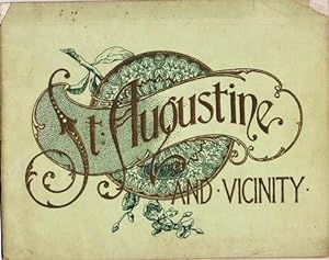
ST. AUGUSTINE AND VICINITY
Published by J. Murray Jordan, Philadelphia, 1905
Seller: R & A Petrilla, Booksellers & Appraisers, Roosevelt, NJ, U.S.A.
Seller rating 4 out of 5 stars
Decorated Wrappers. Condition: Good. Early edition. (24)pp views from photographs. View include: City Gates; Sea Wall; Oldest House; Treasury Street; St. George Street; Charlotte Street; Hotel Ponce de Leon; The Alcazar; Fort Marion; &c. Bound in gilt-embossed green wrappers; upper corners of cover chipped. 7.75" x 9.75".
-
An Engineer's Note Book
Published by Allen, Lane and Scott, 1955
Seller: Peter L. Masi - books, MONTAGUE, MA, U.S.A.
Association Member: SNEAB
Seller rating 4 out of 5 stars
Hardcover. Condition: Used - Very Good. Allen, Lane and Scott, Philadelphia, 1955. x, 164 pages. Illustrated. 11.25 x 9.25", hardcover, no dj. No dj, clean, tight, VG/none.
-
Florida Land Claims - United States v. Arredondo
Published by Handwritten Letter, St. Augustine, 1832
Seller: The First Edition Rare Books, LLC, Cincinnati, OH, U.S.A.
Association Member: ABAA ILAB IOBA MWABA
Seller rating 5 out of 5 stars
Signed
Cloth. Condition: Very good. Letter from Judge John Drysdale of St. Augustine, Florida in 1832, after the United States vs. Arredondo confirmed his ownership of 3,131 acres of land in Florida. In this letter, he requests that attorney George S. Brown of St. Mary's, Georgia, sell (illustrator). Handwritten letter. Large folio, blue cloth folder, title on label affixed to front cover. Full piece measures 11.5" x 17". Letter encased in archival sleeve. Previously folded, letter is two pages, with two archival repairs along the top fold. Dated June 27th, 1832, with postal stamp from the following day. Addressed to George S. Borwn, Esq of St. Mary's Georgia, with stamp and rate on cover. John Drysdale (1783-1845) served as Mayor of St. Augustine, Florida, from 1827-1830. He was an attorney by trade, also serving as an Alderman in 1823 and County Judge of St. Johns County. A unique piece of early Florida land speculation. In the case of United States v. Arredondo, decided in 1832, the United States Supreme Court addressed a land grant dispute stemming from the Adams-On�s Treaty of 1819, whereby Spain ceded Florida to the United States. The Arredondo case involved a claim by the Arredondo family, who sought confirmation of a Spanish land grant awarded before the territory's transfer to the U.S. The grant covered over 1.5 million acres in what is now Alachua County, Florida. The Court's decision, penned by Justice Joseph Story, upheld the validity of the Arredondo grant under the terms of the Adams-On�s Treaty, which recognized land grants made by Spain before the cession. This landmark case established significant legal precedent in U.S. property law, particularly regarding the recognition and confirmation of land titles and grants in territories acquired by the United States, setting a framework for the treatment of former Spanish land grants within American jurisprudence. Signed.
-
St. Augustine.
Publication Date: 1980
Seller: Geographicus Rare Antique Maps, Brooklyn, NY, U.S.A.
Association Member: ABAA ESA ILAB
Seller rating 4 out of 5 stars
Map
Good. Newsprint. Some toning and wear. Slight infill at bottom to the left of the word 'Limit'. Size 33 x 22.5 Inches. This is Henry Hird III's 1980 'sightseeing' map of St. Augustine, Florida. The map illustrates the historic parts of St. Augustine during the rush to preserve the city's historic architecture, primarily driven by the St. Augustine Historical Society and the Historic St. Augustine Preservation Board. Their dedicated efforts transformed St. Augustine into the popular tourist destination it is today. A Closer Look Two maps on one large sheet of newsprint, with print advertisements for local businesses on the verso. The lower map details 'Old St. Augustine', including frontage along Matazanas Bay and the Intercostal Waterway. The upper map is a more general illustration of the St. Augustine area, including Anastasia Island, the historic area, the San Sebastian River, and Vilano Beach. Downtown St. Augustine Oriented towards the west, this view presents the historical area of St. Augustine, with the oldest Spanish colonial structures near Matanzas Bay in the foreground. These include the Castillo de San Marcos, constructed in the late 17th century, and the Basilica Cathedral of St. Augustine, built in the late Spanish period at the end of the 18th century. The Bridge of Lions, in the foreground, perhaps the most distinctive structure in St. Augustine, was completed in 1927 on the tail end of the Florida Land Boom. By the end of the 20th century, the bridge suffered from structural problems and had to be considerably renovated, a process completed in 2011. St. Augustine General Map Oriented towards the west, this map embraces the broader region around St. Augustine's historic downtown, highlighting local businesses and roads, with connections to major roads and highways, waterways, parks, entertainment venues (including an alligator farm!), and important historical sites, which are accompanied by explanatory text. An inset at left displays a continuation of the A1A South and Marineland, a groundbreaking oceanarium or marine attraction that established a model copied elsewhere in Florida and beyond many times since. The verso includes additional advertisements for local shops, restaurants, and attractions, which are tagged with coordinates corresponding to a grid in the border of the map on the recto. Publication History and Census This map was drafted by Henry Hird III and published by Atlantique Press as a 'Free Sightsing Map' (Limit one per family). Although not stated specifically on the map, it was likely heavily subsidized, if not outright financed, by 'St. Augustine by Sighseeting Trains', one of the more popular and still operating local attractions. We are aware of several editons. The present example is dated 1980, and may be the earliest. We note another example, where the maps are separated, issued in 1985.
-

Pagus Hispanorum in Florida.
Publication Date: 1671
Seller: Geographicus Rare Antique Maps, Brooklyn, NY, U.S.A.
Association Member: ABAA ESA ILAB
Seller rating 4 out of 5 stars
Map
Excellent. Two tiny wormholes, else fine. Size 10.5 x 13.75 Inches. This is a beautifully realized Arnoldus Montanus/John Ogilby view of the Spanish settlement of St. Augustine, Florida, the oldest European city within the bounds of what would be the United States. St. Augustine was founded by Pedro Menendez in 1565 to protect the northernmost frontier of the Spanish Empire on America's east coast and to project Spanish power over the trade route passing from the Gulf of Mexico through the passage between Florida and the Bahamas. A Closer Look The walled settlement is shown in good order, with buildings both within and without; cannon peek through tower portals. To the left, closely set houses interspersed with church steeples march up the foothills of imaginary mountains. The scene is very lively: Spanish colonial grandees follow wagonloads of goods down to the waterfront, with natives wrangling the cargo whilst an enslaved African carries a parasol over a veiled Spanish woman. The river is busy with small craft and three moored warships. This view is understood to have been informed by the plan of the settlement produced by Baptista Boazio, who accompanied Sir Francis Drake during his raids on the city in 1586. Nonetheless, the present view bears little resemblance to Boazio's map. Publication History and Census This view was prepared for Arnoldus Montanus' 1671 De Nieuwe en Onbekende Werlde , engraved by Jacob van Meurs, and was included unchanged in John Ogilby's book America being the latest, and most accurate description of the New World , printed the same year. We see 8 separate examples listed in OCLC; the view appears on the market from time to time. References: OCLC 651971896.
-

Befestigungsgrundri�, "Piano della Ciatta, e Porto di Sant. Agostino".
Language: German
Seller: Antiquariat Clemens Paulusch GmbH, Berlin, Germany
Seller rating 5 out of 5 stars
Art / Print / Poster
Kupferstich v. Vanni n. G. Pazzi aus Il Gazzettiere Americano, 1763, 20 x 28,7.