Order Total (1 Item Items):
Shipping Destination:

Frederick Wit 1629 (9 results)
Skip to main search results
Search filters
Product Type
- All Product Types
- Books (No further results match this refinement)
- Magazines & Periodicals (No further results match this refinement)
- Comics (No further results match this refinement)
- Sheet Music (No further results match this refinement)
- Art, Prints & Posters (2)
- Photographs (No further results match this refinement)
- Maps (7)
- Manuscripts & Paper Collectibles (No further results match this refinement)
Condition Learn more
- New (No further results match this refinement)
- As New, Fine or Near Fine (2)
- Very Good or Good (6)
- Fair or Poor (No further results match this refinement)
- As Described (1)
Binding
- All Bindings
- Hardcover (No further results match this refinement)
- Softcover (No further results match this refinement)
Collectible Attributes
- First Edition (No further results match this refinement)
- Signed (No further results match this refinement)
- Dust Jacket (No further results match this refinement)
- Seller-Supplied Images (9)
- Not Print on Demand (9)
Language (2)
Price
- Any Price
- Under US$ 25 (No further results match this refinement)
- US$ 25 to US$ 50 (No further results match this refinement)
- Over US$ 50
Free Shipping
- Free Shipping to U.S.A. (No further results match this refinement)
Seller Location
Seller Rating
-
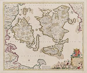
Insularum Danicarum ut Zee-Landiae, Fioniae, Langelandiae, Lalandiae, Falstriae, Fembriae, Monae, aliquarumque in Mari Balthico Sitarum descriptio
Published by Amsterdam, F. de Wit, [c.]., 1680
Seller: Inanna Rare Books Ltd., Skibbereen, CORK, Ireland
Seller rating 5 out of 5 stars

Art / Print / Poster
Original hand-coloured engraving. Plate Size: 58.1 cm x 48.8 cm. Sheet Size: 63.8 cm x 53 cm. Original map. In very good condition with only the slightest hints of browning to outer margns only. This beautifully engraved chart shows the main Danish islands of Funen and Zealand plus the eastern coastline of the Jutland peninsula and a little of southern Sweden. The major Danish cities like Copenhagen, Aarhus and Odense are shown on the map. The map is filled with minute detail of fortresses, cities, towns and tiny villages. Relief depicted pictorially The lower right corner of the map bears a stunningly decorative cartouche featuring the Danish royal coat-of-arms and a Classical scene of putti and merfolk frolicking in the sea with the god Mercury in the foreground. A small compass rose lies off the Schleswig Holstein coast in the Colberger Heide. Frederick de Wit (1629/1630 1706) was a Dutch cartographer and artist who drew, printed and sold maps. By 1648, during the height of the Dutch Golden Age, De Wit had moved from Gouda to Amsterdam. As early as 1654 he had opened a printing office and shop under the name "De Drie Crabben" (the Three Crabs) which was also the name of his house on the Kalverstraat. In 1655, De Wit changed the name of his shop to the "Witte Pascaert" (the White Chart). Under this name De Wit and his firm became internationally known. The first cartographic images that De Wit engraved were a plan of Haarlem that has been dated to 1648. The first charts engraved by De Wit were published in 1654 under the "De Drie Crabben" address. The first map that was both engraved and dated by De Wit was that of Denmark: "REGNI DANI� Accuratissima delineatio Perfeckte Kaerte van 't CONJNCKRYCK DENEMARCKEN" in 1659. His first world maps, "NOVA TOTIUS TERRARUM ORBIS TABULA AUCTORE F. DE WIT" and Nova Totius Terrarum Orbis Tabula appeared around 1660. His Atlas began to appear around 1662 and by 1671 included anywhere from 17 to 151 maps each. In the 1690s he began to use a new title page "Atlas Maior" but continued to use his old title page. His atlas of the Low Countries first published in 1667, was named Nieuw Kaertboeck van de XVII Nederlandse Provinci�n and contained 14 to 25 maps. De Wit quickly expanded upon his first small folio atlas which contained mostly maps printed from plates that he had acquired, to an atlas with 27 maps engraved by or for him. By 1671 he was publishing a large folio atlas with as many as 100 maps. After Frederick de Wit's death in 1706 his wife Maria continued the business for four years printing and editing De Wit's maps until 1710. However, as De Wit's son Franciscus was already a prosperous merchant by this time and had little interest in his father's business, he did not take over the publishing house. In 1710 Maria sold the firm at auction. At the auction most of the atlas plates and some of the wall map were sold to Pieter Mortier, whose publishing company grew to become one of the largest cartography publishing houses of the 18th century. The 27 chart plates from his 1675 Sea atlas were sold at the 1710 auction, to the Amsterdam print seller Luis Renard, who published them under his own name in 1715, and then sold them to Rennier and Joshua Ottens who continued to publish them until the mid-1700s. (Wikipedia).
-
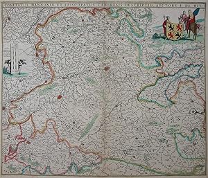
Comitatus Hannoniae et Episcopatus Cambresis descritio
Language: German
Publication Date: 1690
Seller: Kunstantiquariat Andreas Senger, Hamburg, Germany
Seller rating 5 out of 5 stars
Map
Kein Einband. Condition: Gut. Es handelt sich hierbei um eine originale, kolorierte Kupferstich-Landkarte des Gebiets der Grafschaft Hennegau von Frederick de Wit aus dem Jahr 1690. *** Titel: Comitatus Hannoniae et Episcopatus Cambresis descritio *** Gebiet bzw. Ort: Grafschaft Hennegau auf dem Gebiet des heutigen Belgien und Frankreich. Im Westen Tournai, im Norden bis Lessines, im Osten Charleroi, im S�den bis Cambrai. *** Kartograph: Frederick de Wit (1629 - 1706) *** Jahr: 1690 *** Gr��e des Plattenbereichs: 47 x 55 cm *** Technik: Kupferstich *** Zustand (Perfekt/ Sehr gut/ Gut/ Ordentlich/ M��ig/ Schlecht): In gutem Erhaltungszustand. Altersgem�� leicht gebr�unt. *** Bemerkungen: Detaillierte Karte der Grafschaft Hennegau mit dekorativer Ritterstaffage. - - - International buyers welcome. If you have any questions, please don't hesitate to ask. --- Auf Wunsch stellen wir Ihnen gerne ein kostenfreies Echtheitszertifikat aus --- If you wish, we will gladly provide a certificate of authenticity free of charge ---.
-
Iutiae tabula in qua sunt Dioeceses Alburgensis
Language: German
Publication Date: 1680
Seller: Kunstantiquariat Andreas Senger, Hamburg, Germany
Seller rating 5 out of 5 stars
Map
Kein Einband. Condition: Sehr gut. Es handelt sich hierbei um eine originale, kolorierte Kupferstich-Landkarte J�tlands von Frederick de Wit (1629 - 1706) aus dem Jahr 1680. *** Titel: Iutiae tabula in qua sunt Dioeceses Alburgensis *** Gebiet bzw. Ort: J�tland, K�nigreich D�nemark *** Kartograph: Frederick de Wit (1629 - 1706) *** Jahr: 1680 *** Gr��e des Plattenbereichs: 58 x 48 cm *** Technik: Kupferstich *** Zustand (Perfekt/ Sehr gut/ Gut/ Ordentlich/ M��ig/ Schlecht): In sehr gutem Erhaltungszustand *** Bemerkungen: - - - - International buyers welcome. If you have any questions, please don't hesitate to ask. --- Auf Wunsch stellen wir Ihnen gerne ein kostenfreies Echtheitszertifikat aus --- If you wish, we will gladly provide a certificate of authenticity free of charge ---.
-
Archiepiscopatus et Electoratus Moguntini et adjacentium Regionium ut Landgraviatuum
Language: German
Publication Date: 1690
Seller: Kunstantiquariat Andreas Senger, Hamburg, Germany
Seller rating 5 out of 5 stars
Map
Kein Einband. Condition: Gut. Es handelt sich hierbei um eine originale, kolorierte Kupferstich-Landkarte des Gebiets des Erzbistums Mainz von Frederick de Wit (1629 - 1706) aus dem Jahr 1690. *** Titel: Archiepiscopatus et Electoratus Moguntini et adjacentium Regionium ut Landgraviatuum � *** Gebiet bzw. Ort: Erzbistum Mainz *** Kartograph: Frederick de Wit (1629 - 1706) *** Jahr: 1690 *** Gr��e des Plattenbereichs: 49,5 x 60 cm *** Technik: Kupferstich *** Zustand (Perfekt/ Sehr gut/ Gut/ Ordentlich/ M��ig/ Schlecht): In gutem Erhaltungszustand *** Bemerkungen: Mittelfalte hinterlegt. - - - International buyers welcome. If you have any questions, please don't hesitate to ask. - - - ----- Auf Wunsch stellen wir Ihnen gerne ein kostenfreies Echtheitszertifikat aus ------ If you wish, we will gladly provide a certificate of authenticity free of charge ---.
-
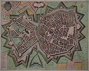
Atrebatum Gallis Arras, Belgis Atrecht dicta
Language: German
Seller: Kunstantiquariat Andreas Senger, Hamburg, Germany
Seller rating 5 out of 5 stars
Art / Print / Poster
Kein Einband. Condition: Gut bis sehr gut. Es handelt sich hierbei um einen seltenen, originalen, kolorierten Kupferstichplan der Stadt Arras von Pieter van der Aa nach Frederick de Wit nach Joan Blaeu aus dem Jahr 1729. *** Titel: Atrebatum Gallis Arras, Belgis Atrecht dicta *** Gebiet bzw. Ort: Arras in Nordfrankreich *** Kartograph: Pieter van der Aa (1659 - 1733) nach Frederick de Wit (1629 - 1706) nach Joan Blaeu (1596 - 1673)*** Jahr: 1729 *** Gr��e des Plattenbereichs: ca. 41 x 52 cm *** Technik: Kupferstich *** Zustand (Perfekt/ Sehr gut/ Gut/ Ordentlich/ M��ig/ Schlecht): In sehr gutem Erhaltungszustand mit originalen Faltstellen *** Bemerkungen: Sehr seltener Plan von Arras mit seinen Befestigungsanlagen, Stadtwappen und einer Legende der 19 wichtigsten Geb�ude. Kupferstich von einer Platte aus Joan Blaeus St�dtebuch "Novum Ac Magnum Theatrum Urbium Belgicae" (= "Stedeboeck"), Amsterdam, J. Blaeu, 1649. In einer sp�teren Auflage von 1729 nach Frederick de Wit, verlegt bei Pieter van der Aa aus dem Werk 'La Galerie Agreable Du Monde .', die in nur 100 Exemplaren verlegt wurde. Lateinischer Text. - - - International buyers welcome. If you have any questions, please don't hesitate to ask. --- Auf Wunsch stellen wir Ihnen gerne ein kostenfreies Echtheitszertifikat aus --- If you wish, we will gladly provide a certificate of authenticity free of charge ---.
-
Circulus Saxoniae Inferioris in quo sunt Ducatus Holsatiae, Meklenburgi, Lauwenburgi, Luneburgi, Brunsuigi, Bremae et Ferdae Comitatus Dannebergi
Language: German
Publication Date: 1730
Seller: Kunstantiquariat Andreas Senger, Hamburg, Germany
Seller rating 5 out of 5 stars
Map
Kein Einband. Condition: Gut. Es handelt sich hierbei um eine originale, kolorierte Kupferstich-Landkarte des Gebiets von Niedersachsen und Mecklenburg-Vorpommern von Covens & Mortier nach Frederick de Wit (1629 - 1706) aus dem Jahr 1730. *** Titel: Circulus Saxoniae Inferioris in quo sunt Ducatus Holsatiae, Meklenburgi, Lauwenburgi, Luneburgi, Brunsuigi, Bremae et Ferdae Comitatus Dannebergi *** Gebiet bzw. Ort: Niedersachsen, Mecklenburg-Vorpommern, s�dliches Schleswig Holstein *** Kartograph: Covens & Mortier nach Frederick de Wit (1629 - 1706) *** Jahr: 1730 *** Gr��e des Plattenbereichs: 48 x 56 cm *** Technik: Kupferstich *** Zustand (Perfekt/ Sehr gut/ Gut/ Ordentlich/ M��ig/ Schlecht): In gutem Erhaltungszustand *** Bemerkungen: Randbereiche teilweise hinterlegt. Leicht gebr�unt. - - - International buyers welcome. If you have any questions, please don't hesitate to ask. --- Auf Wunsch stellen wir Ihnen gerne ein kostenfreies Echtheitszertifikat aus --- If you wish, we will gladly provide a certificate of authenticity free of charge ---.
-
Ducatus Slesvicensis in omnes suas Praefecturas Circulos et Provincias Distinte Divisus Per Fredericum De Witt Amstelodami
Language: German
Publication Date: 1690
Seller: Kunstantiquariat Andreas Senger, Hamburg, Germany
Seller rating 5 out of 5 stars
Map
Kein Einband. Condition: Gut. Es handelt sich hierbei um eine originale, kolorierte Kupferstich-Landkarte des Gebiets von Schleswig Holstein von Frederick de Wit (1629 - 1706) aus dem Jahr 1690. *** Titel: Ducatus Slesvicensis in omnes suas Praefecturas Circulos et Provincias Distinte Divisus Per Fredericum De Witt Amstelodami *** Gebiet bzw. Ort: Schleswig Holstein *** Kartograph: Frederick de Wit (1629 - 1706) *** Jahr: 1690 *** Gr��e des Plattenbereichs: 49 x 57 cm *** Technik: Kupferstich *** Zustand (Perfekt/ Sehr gut/ Gut/ Ordentlich/ M��ig/ Schlecht): In gutem Erhaltungszustand *** Bemerkungen: Mittelfalte hinterleg. Altersgem�� gering gebr�unt. - - - International buyers welcome. If you have any questions, please don't hesitate to ask. --- Auf Wunsch stellen wir Ihnen gerne ein kostenfreies Echtheitszertifikat aus --- If you wish, we will gladly provide a certificate of authenticity free of charge ---.
-
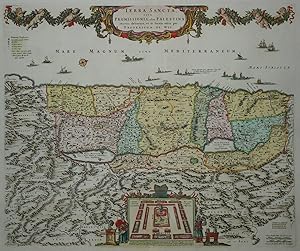
Terra Sancta, sive Promissionis, olim Palestina recens delineata, et in lucem edita per Fredericum De Wit
Language: German
Publication Date: 1680
Seller: Kunstantiquariat Andreas Senger, Hamburg, Germany
Seller rating 5 out of 5 stars
Map
Kein Einband. Condition: Gut. Es handelt sich hierbei um eine originale, altkolorierte Kupferstich-Landkarte des heiligen Landes von Frederick de Wit (1629 - 1706) aus dem Jahr 1680. *** Titel: Terra Sancta, sive Promissionis, olim Palestina recens delineata, et in lucem edita per Fredericum De Wit *** Gebiet bzw. Ort: Heiliges Land - Israel - Pal�stina *** Kartograph: Frederick de Wit (1629 - 1706) *** Jahr: 1680 *** Gr��e des Plattenbereichs: 46 x 54 cm *** Technik: Kupferstich *** Zustand (Perfekt/ Sehr gut/ Gut/ Ordentlich/ M��ig/ Schlecht): In gutem Erhaltungszustand. Ein kleiner Einri� in der Bugfalte im unteren Bereich restauriert. Eine gegl�ttete, diagonale Knickfalte in der Blattmitte. *** Bemerkungen: Seltene westorientierte Karte Pal�stinas in dekorativem Altkolorit. Sie zeigt die Mittelmeerk�ste von Sidon bis zur Sinai Halbinsel sowie die Gebiete der 12 St�mme Israels. Am unteren Bildrand Darstellung eines Lagers der St�mme um den Tabernakel, flankiert durch zwei Figuren, Moses und Aaron darstellend. - - - International buyers welcome. If you have any questions, please don't hesitate to ask. --- Auf Wunsch stellen wir Ihnen gerne ein kostenfreies Echtheitszertifikat aus --- If you wish, we will gladly provide a certificate of authenticity free of charge ---.
-
Daniae, Frisiae, Groningae et Orientalis Frisiae Littora
Language: German
Publication Date: 1690
Seller: Kunstantiquariat Andreas Senger, Hamburg, Germany
Seller rating 5 out of 5 stars
Map
Kein Einband. Condition: Gut. Es handelt sich hierbei um eine originale, altkolorierte Kupferstich-Landkarte des Gebiets der Nord- und Ostsee von Frederick de Wit (1629 - 1706) aus dem Jahr 1690. *** Titel: Daniae, Frisiae, Groningae et Orientalis Frisiae Littora *** Gebiet bzw. Ort: Norddeutschland, Niederlande, D�nemark, Schweden *** Kartograph: Frederick de Wit (1629 - 1706) *** Jahr: 1690 *** Gr��e des Plattenbereichs: 49 x 57 cm *** Technik: Kupferstich *** Zustand (Perfekt/ Sehr gut/ Gut/ Ordentlich/ M��ig/ Schlecht): In gutem Erhaltungszustand. Altersgem�� leicht gebr�unt. Mittelfalte im oberen Bereich fachgerecht hinterlegt. *** Bemerkungen: Altkolorierte, westorientierte Seekarte der Nord- und Ostsee von Amsterdam und der Zuidersee �ber die West-, ost- und nordfriesischen Inseln, D�nemark und Rostock bis zur schwedischen Westk�ste . Rares, sehr dekoratives Blatt mit gro�er fig�rlicher Kartusche, zwei Windrosen und Segelschiffen. - - - International buyers welcome. If you have any questions, please don't hesitate to ask. --- Auf Wunsch stellen wir Ihnen gerne ein kostenfreies Echtheitszertifikat aus --- If you wish, we will gladly provide a certificate of authenticity free of charge ---.