Fricx Eugene Henri (7 results)
 More images
Published by Fricx, Eugene Henri, Brussels 1707
Seller: poor man's rare books (mrbooks) IOBA NJB, Vineland, NJ, U.S.A.poor man's rare books (mrbooks) IOBA NJB
Contact seller4-star sellerMap. Condition: Very Good with no dust jacket. Belgium; We fit archival quality clear acrylic covers for additional protection whenever possible. ; Color Illustrations; 1 piece. Hand-Colored Engraved Town Plan. Fricx, Eugene Henri. "Plan de la Ville Dostende." Brussels, 1707. Approx. 20 x 28 1/2 inches (508 x 724 mm) ; scattered… light foxing, mat mounted on edges of map, tape repairs on verso.

Published by Paris. 1743 1743
Seller: Peter Harrington. ABA/ ILAB., London, United KingdomPeter Harrington. ABA/ ILAB.
Contact seller5-star sellerCondition: Used
US$ 300.17
US$ 29.14 shippingShips from United Kingdom to U.S.A.Quantity: 1 available
Fricx's famous maps of Belgium and northern France, accurate and detailed, show the fortifications of the towns very clearly, here boldly coloured in red. Originally published in 1712. Atlas Militaire. Copper engraving. Fine condition, good margins. Original colour. Size: 64.3 x 48.5 cm.

Published by Paris. 1744 1744
Seller: Peter Harrington. ABA/ ILAB., London, United KingdomPeter Harrington. ABA/ ILAB.
Contact seller5-star sellerCondition: Used
US$ 375.22
US$ 29.14 shippingShips from United Kingdom to U.S.A.Quantity: 1 available
Fricx's famous maps of Belgium and northern France, accurate and detailed, show the fortifications of the towns very clearly, here boldly coloured in red. Originally published in 1712 in the Atlas Militaire. Copper engraving. Good condition. Tear at top left corner, some loss to margin, not affecting map Later colouring. Size: 6…5 x 49 cm.

Published by Atlas Militaire. 1743 1743
Seller: Peter Harrington. ABA/ ILAB., London, United KingdomPeter Harrington. ABA/ ILAB.
Contact seller5-star sellerCondition: Used
US$ 409.33
US$ 29.14 shippingShips from United Kingdom to U.S.A.Quantity: 1 available
Fricx's famous maps of Belgium and northern France, accurate and detailed, show the fortifications of the towns very clearly, here boldly coloured in red. Originally published in 1712 Copper engraving. Fine condition, good margins. Original colour. Size: 64.3 x 48.5 cm. (25½ x 19 inches).

Published by Artist: Fricx Eugène-Henri ( - 1730 ) Bruxelles ca : 1704 1644
- Art Print
Seller: Antique Sommer& Sapunaru KG, München, , GermanyAntique Sommer& Sapunaru KG
Contact seller4-star sellerCondition: Used
US$ 623.78
US$ 51.42 shippingShips from Germany to U.S.A.Quantity: 1 available
Technic: Copper print, colorit: colored, condition: Some folds, tears perfectly set down, size (in cm): 43 x 59,5 cm, Representation of the disembarkment of the french king at Naples caused by the The War of the Spanish Succession (1702?1715). It was a major European conflict of the early 18th century, triggered by the death in…1700 of the last Habsburg King of Spain, the infirm and childless Charles II. In 1702 the war in northern Italy was in its second year. After Austria's initial success Louis XIV sent Marshal Vendôme to command the Bourbon army, and with greatly superior numbers he began to dominate and pin back his opponent. With the Duke of Savoy's desertion Piedmont-Savoy became an important goal for the French, who now aimed to isolate Victor Amadeus and Starhemberg from the Austrians to the east and secure communications between France and Milan. By the beginning of 1704 Marshal Tessé had taken the Duchy of Savoy.
 More images
- Hardcover
- First Edition
Seller: Herman H. J. Lynge & Søn ILAB-ABF, Copenhagen, , DenmarkHerman H. J. Lynge & Søn ILAB-ABF
Contact seller4-star sellerCondition: Used
US$ 4,408.69
Free ShippingShips from Denmark to U.S.A.Quantity: 1 available
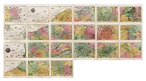
Brussels, 1712. Folio (512 x 315 mm). In contemporary half calf with seven raised bands. Spine and hindges with wear. Leather brittle and upper and lower 10 cm hindges detached. Two library labels pasted on to pasted down front end-paper. Upper margin of first three leaves blind-stamped. Handwritten (19th century hand) index mou…nted in on verso of first map and each map numbered. With 75 maps and plans, many double-page or folding: 24 cartes des Pays Bas, Carte générale de Brabant, Carte du Pays de Waes, Carte des Postes d'Allemagne, 48 plans des Villes, Sièges & Batailles (complete). 3 maps with minor marginal tear (outside plate), 2 with minor split to lower part of middle folding. A few maps at end with browning. A few plates (primarily 61, 50, 33, 25) heavily trimmed with slight loss to upper margin. An overall fine and clean copy. First edition of Fricx?s famous atlas consisting of topographical maps, plans of towns, fortresses, sieges and battlefields. Today Fricx is considered one of the most important map publishers in the Southern Netherlands in the 18th century. This collection of maps and plans of fortifications is also known under the title ?Recueil des cartes des provinces meridionales des Pays Bas et des frontiers de la France. The first 24 maps form together a topographical maps of the Southern Netherlands, scale 1:115.000. Most of the plates were engraved by Jacob Harrewijn. These maps were based on military maps by French engineers and show an accurate representation of the topography. The importance of the map of the Spanish Netherlands is demonstrated by the fact that the 24 sheets were copied in Paris, Augsburg, and Amsterdam. The maps were also published separately. ?The bookseller and printer, Eugéne Henri Fricx, was one of the most important map publishers of the Southern Netherlands in the 18th century. He lived in Brussels where he had his shop on Rue de la Madeleine. His activities in the field started in 1706 with the production of military plans of battles and sieges of the War of Succession. In the same year,he also stated the publication of the map of the Southern Netherlands in 24 sheets it was finished in 1712, apart from the sheet Luxemborg, which was engraved in 1727. He employed Jean Harrewijn of Brussels as an engraver and Cornelis Marke of Middelburg as a contractor for the ?enluminators? Although he had children, his business was not continued after his death (about 1740). His map of the Southern Netherlands was copied by Covens & Mortier and sold until ca. 1780, when it was replaced by Ferraris? Map of the Austrian Netherlands.? (Koeman II, Fri1) Koeman II, Fri1.
[Carte du Theatre de la Guerre aux Pais-Bas].
MORTIER, Pieter (1661-1711) - FRICX, Eugene Henri (1644-1730).
Published by Amsterdam: Chez Pierre Mortier, [1710-1711]. 1711
- Signed
Seller: Arader Galleries - AraderNYC, New York, NY, U.S.A.Arader Galleries - AraderNYC
Contact seller5-star sellerSPECTACULAR MAP OF THE SOUTHERN NETHERLANDS AND NORTHERN FRANCE. 21 double-page engraved map sheets numbered in the engraving 1-21 (each ca. 21 x 24 4/8 inches; 16 2/8 x 22 inches to the neat line; with full margins, showing the plate-mark). Each with EXCEPTIONALLY FINE ORIGINAL HAND-COLOUR IN FULL, with territories shown in dif…ferent bold watercolours of pink, green and yellow, the towns and parishes noted, and the important cities shown in red and HEIGHTENED WITH LIQUID GOLD, the coastline delineated in extraordinary detail with sandbanks shown and the Channel teeming with English, Dutch and French galleons, fishing trawlers and other sail boats, decorated with SUPERB WIND AND COMPASS ROSES, HEIGHTENED WITH LIQUID GOLD, and surrounded by a border of yellow wash (old central vertical creases). [WITH:] Carte d'Artois et des Environs; ou l'on voit le Ressort du Conseil Provincial d'Artois: Dresse sur les Observations de M.rs de L'Academie des Sciences. Par G. de l'Isle. Amsterdam: Chez Pierre Mortier. (21 x 24 4/8 inches; 19 2/8 x 24 inches to the neat line; with full margins, showing the plate-mark). A very fine and detailed map of the southern Netherlands and northern France, with EXCEPTIONALLY FINE ORIGINAL HAND-COLOUR IN FULL, with territories shown in different bold watercolours of pink, green and yellow, the towns and parishes noted, and the important cities shown in red and HEIGHTENED WITH LIQUID GOLD, the title within a banner across the top of the map, and within a large and extravagant allegorical cartouche, upper right, HEIGHTENED WITH LIQUID GOLD, decorated with a fine compass rose HEIGHTENED WITH LIQUID GOLD, and surrounded by a border of yellow wash, with the BATTLE LINES DRAWN AND ANNOTATED IN LIQUID GOLD, and dated between 1705 and 1711, CLEARLY SERVING AS A KEY-MAP. Provenance: each map with an additional contemporary manuscript number in the top right-hand corner of the margin; 11 of the maps with the BATTLE LINES DRAWN AND ANNOTATED IN LIQUID GOLD, and dated between 1704 and 1711. A BEAUTIFUL EXAMPLE OF THIS RARE, IMPORTANT AND LARGE-SCALE MAP, WHICH IF JOINED WOULD MAKE A SUPERB WALL MAP OF THE FIELD OF BATTLE FOR THE WAR OF SPANISH SUCCESSION (1701-1714) IN THAT PART OF EUROPE, AND IS ALL THAT WAS PUBLISHED OF THE SERIES BY PIETER MORTIER BEFORE HIS DEATH IN 1711, originally published by Eugene Henri Fricx between 1706 and 1712, in two parts: the first 23 maps forming a large topographical map of the southern Netherlands, as here, followed by 3 general maps and then 47 maps or plans of towns, sieges or battles. The current example is Mortier's version of the first part of Fricx's atlas, copied, improved and augmented by the celebrated Amsterdam cartographical publisher, up to and including the maps issued by Fricx to 1710-1711, eleven maps are illuminated with BATTLE LINES DRAWN AND ANNOTATED IN LIQUID GOLD, and dated between 1704 and 1711, on the first map Carte Particuliere d'une Partie d'Angleterre, Mortier states that his map IS COMPLETE IN 18 SHEETS "Cette Carte Contient 18 fuilles", so, published before a further three maps: "Carte Particuliere des environs d'Avesnes, Landrecy, La Capelle, Guise.", 1712, "Carte Particuliere des environs de Philleville, Charlemont, Marienbiurg, Rocroy.", 1712, and a third map, which might have been a key-map of the "Theatre de la guerre", published as early as 1703, but here replaced by the Carte d'Artois et des Environs; ou l'on voit le Ressort du Conseil Provincial d'Artois: Dresse sur les Observations de M.rs de L'Academied des Sciences. Par G. de l'Isle. Amsterdam: Chez Pierre Mortier, a very fine and detailed map of the southern Netherlands and northern France, with the BATTLE LINES DRAWN AND ANNOTATED IN LIQUID GOLD, and dated between 1705 and 1711. The War of Spanish Succession (17011714) was fought between the major European powers, including a divided Spain, over who had the right to succeed Charles II as King of Spain. That conflict spread to include Amer. Signed by Author(s).


