
Order Total (1 Item Items):
Shipping Destination:

Gallup Map Co (6 results)
Skip to main search results
Search filters
Product Type
- All Product Types
- Books (6)
- Magazines & Periodicals (No further results match this refinement)
- Comics (No further results match this refinement)
- Sheet Music (No further results match this refinement)
- Art, Prints & Posters (No further results match this refinement)
- Photographs (No further results match this refinement)
- Maps (No further results match this refinement)
- Manuscripts & Paper Collectibles (No further results match this refinement)
Condition Learn more
- New (No further results match this refinement)
- As New, Fine or Near Fine (No further results match this refinement)
- Very Good or Good (3)
- Fair or Poor (No further results match this refinement)
- As Described (3)
Binding
- All Bindings
- Hardcover (No further results match this refinement)
- Softcover (2)
Collectible Attributes
- First Edition (No further results match this refinement)
- Signed (No further results match this refinement)
- Dust Jacket (No further results match this refinement)
- Seller-Supplied Images (3)
- Not Print on Demand (6)
Language (2)
Free Shipping
Seller Location
Seller Rating
-

Gallup Map Kansas City Atlas
Language: English
Published by Gallup Map Co. (edition 4th), 2005
ISBN 10: 0966313410 ISBN 13: 9780966313413
Ring-bound. Condition: Very Good. 4th. It's a well-cared-for item that has seen limited use. The item may show minor signs of wear. All the text is legible, with all pages included. It may have slight markings and/or highlighting.
-
Gallup Map Kansas City Atlas
Seller: World of Books (was SecondSale), Montgomery, IL, U.S.A.
Seller rating 5 out of 5 stars

Condition: Good. Item in good condition. Textbooks may not include supplemental items i.e. CDs, access codes etc.
-
Unknown. Condition: Good. No Jacket. Pages can have notes/highlighting. Spine may show signs of wear. ~ ThriftBooks: Read More, Spend Less.
-
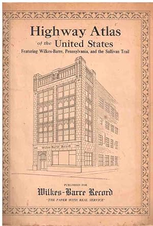
Gallup's Highway Atlas of the United States with City Maps, Index to Population, Fish, Game and Motor Laws
Published by Kansas City, MO, Kansas City, MO, 1929
Seller: High Ridge Books, Inc. - ABAA, South Deerfield, MA, U.S.A.
Association Member: ABAA ESA ILAB SNEAB
Seller rating 5 out of 5 stars
Stiff printed illustrated wrappers with moderate wear but generally very good condition. 64 pp., with maps of each state printed in red and blue. This edition was published specifically for the Wilkes-Barre (PA) Record, with a view of that newspaper's building on the front and two views aound Wilkes-Barre on the back cover. The maps show the major routes but also have keys which distinguish main from other roads and show their composition (paved, dirt, under construction, etc.) OCLC 1032293335 (5 loc.), Phillips (Atlas) 10806.
-
Color-printed, 8.5 x 11 inches, folding into orange pictorial paper wrappers. Printed on both sides, with a detailed plan of the central business district on one side, and an "Auto Route Guide" to Metropolitan Kansas City on the other. The map of the Central Business District is specifically designed to illustrate degrees of parking restrictions, which are shown in various shades of red. The other side of the sheet includes a street index, and ads for the Gallup Map & Supply Company. Condition: Orange stiff paper wrappers stained on either side else fine.
-

Official Guide to Roads and Highways - Kansas City and Surrounding Territory
Published by Kansas City, Kansas City, 1919
Seller: High Ridge Books, Inc. - ABAA, South Deerfield, MA, U.S.A.
Association Member: ABAA ESA ILAB SNEAB
Seller rating 5 out of 5 stars
Folding map in original printed wrappers, front wrapper detached and chipped at top right corner. Map is in fine condition. Shows a large area from Guthrie, Oklahoma to Chillicothe, Missouri. Major roads highlighted in red. At the right side are trail markers, coded roadside indicators of different routes, before state, county and federal roads were numbered.
![Seller image for [Map of Kansas City] for sale by DuBois Rare Books](https://pictures.abebooks.com/inventory/md/md30424843413.jpg)