Gallup Map (9 results)

Seller: BooksRun, Philadelphia, PA, U.S.A.BooksRun
Contact seller5-star sellerCondition: Used - Very good
US$ 14.03
Free ShippingShips within U.S.A.Quantity: 1 available
Ring-bound. Condition: Very Good. 4th. It's a well-cared-for item that has seen limited use. The item may show minor signs of wear. All the text is legible, with all pages included. It may have slight markings and/or highlighting.
Seller: World of Books (was SecondSale), Montgomery, IL, U.S.A.World of Books (was SecondSale)
Contact seller5-star sellerCondition: Used - Good
US$ 14.21
Free ShippingShips within U.S.A.Quantity: 2 available
Condition: Good. Item in good condition. Textbooks may not include supplemental items i.e. CDs, access codes etc.
Seller: ThriftBooks-Dallas, Dallas, TX, U.S.A.ThriftBooks-Dallas
Contact seller5-star sellerCondition: Used - Good
US$ 16.08
Free ShippingShips within U.S.A.Quantity: 1 available
Unknown. Condition: Good. No Jacket. Pages can have notes/highlighting. Spine may show signs of wear. ~ ThriftBooks: Read More, Spend Less.

Published by Gallups Map & Supply Co
- Softcover
Seller: GridFreed, San Diego, CA, U.S.A.GridFreed
Contact seller5-star sellerCondition: Used - Good
US$ 89.50
US$ 6.95 shippingShips within U.S.A.Quantity: 1 available
Paperback. Condition: Good. Good with wear and markings. Looks like an interesting title.
 More images
Published by Kansas City, MO, Kansas City, MO 1929
- Softcover
Seller: High Ridge Books, Inc. - ABAA, South Deerfield, MA, U.S.A.High Ridge Books, Inc. - ABAA
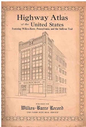
Contact seller5-star sellerStiff printed illustrated wrappers with moderate wear but generally very good condition. 64 pp., with maps of each state printed in red and blue. This edition was published specifically for the Wilkes-Barre (PA) Record, with a view of that newspaper's building on the front and two views aound Wilkes-Barre on the back cover. The…maps show the major routes but also have keys which distinguish main from other roads and show their composition (paved, dirt, under construction, etc.) OCLC 1032293335 (5 loc.), Phillips (Atlas) 10806.
 More images
Published by np [GALLUP MAP & SUPPLY CO.], np [Kansas City] 1925
Seller: DuBois Rare Books, New York, NY, U.S.A.DuBois Rare Books
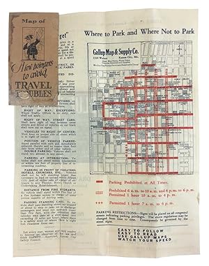
Contact seller5-star sellerColor-printed, 8.5 x 11 inches, folding into orange pictorial paper wrappers. Printed on both sides, with a detailed plan of the central business district on one side, and an "Auto Route Guide" to Metropolitan Kansas City on the other. The map of the Central Business District is specifically designed to illustrate degrees of par…king restrictions, which are shown in various shades of red. The other side of the sheet includes a street index, and ads for the Gallup Map & Supply Company. Condition: Orange stiff paper wrappers stained on either side else fine.

Published by Kansas City, Kansas City 1919
- Softcover
Seller: High Ridge Books, Inc. - ABAA, South Deerfield, MA, U.S.A.High Ridge Books, Inc. - ABAA
Contact seller5-star sellerFolding map in original printed wrappers, front wrapper detached and chipped at top right corner. Map is in fine condition. Shows a large area from Guthrie, Oklahoma to Chillicothe, Missouri. Major roads highlighted in red. At the right side are trail markers, coded roadside indicators of different routes, before state, county a…nd federal roads were numbered.

Gallup New Mexico The Indian Capital / Pictorial Map of Gallup New Mexico.
1947 Ewing Pictorial Map of Gallup, New Mexico: Native American Theme
- Map
Seller: Geographicus Rare Antique Maps, Brooklyn, NY, U.S.A.Geographicus Rare Antique Maps
Contact seller4-star sellerGood. Wear along original fold lines. Verso repair to a fold separation and a closed edge tear. Text and printed images on verso. Slight loss at 2 fold intersections. Size 22 x 15.5 Inches. A distinctive 1947 Louie H. Ewing pictorial map of Gallup, New Mexico, prepared for the Gallup Chamber of Commerce. It highlights the region…'s rich Native American history and culture. A Closer Look Taking some artistic liberties with scale, Ewing's map embraces the Four Corners, Monument Valley, and Mesa Verde in the north and Zuni (or Zuni Pueblo) in the south. Historic paths between settlements and the modern U.S. Route 66 are traced. Historic ruins, existing Native American settlements (reservations), and cities are illustrated and labeled throughout, along with prominent topographic features such as the Painted Desert, Petrified Forest, and Bluewater Lake. References to historical events and local cultures also appear, including Coronado's Expedition, Hopi Snake Dancers, and the Zuni Shalako ceremony. The verso includes a less stylized map of the same region (though still with pictorial elements) noting paved and unsurfaced roads, along with photographs and text of local attractions (national parks, national monuments, etc.) and cultures (especially Hopi and Zuni). Publication History and Census This pictorial map was drawn by local artist and specialist of Native American art Louie H. Ewing, at the behest of the Gallup Chamber of Commerce. It is undated but assumed to be from c. 1947, given the style and Ewing's professional activities. It is scarce in institutional collections, noted among the holdings of the University of New Mexico, University of Colorado Boulder, Southern Methodist University, and University of Southern Maine in the OCLC. References: OCLC 810337681.
 More images
- Map
Seller: Geographicus Rare Antique Maps, Brooklyn, NY, U.S.A.Geographicus Rare Antique Maps
Contact seller4-star sellerVery good. Light wear along original fold lines. Two small areas of loss at fold intersections. Verso repair to a fold separation. Soiling where previously attached to guidebook. Map of Kansas City, Kansas on verso. Size 22.5 x 13 Inches. A c. 1920 folding map of Kansas City, Missouri published by the Gallup Map and Supply Compa…ny. It shows the city near its population peak, when a series of impressive infrastructure and public works projects reshaped the city. A Closer Look The most striking feature of this map is the bold red and green colors used to mark out the city's streetcar lines (48 of them, indexed at top) and greenspaces, respectively. These serve as a reminder of the conception of urban planning in the era before automobiles became dominant. An alphanumeric grid in the margins provides an easy method for locating sites and neighborhoods throughout the city. Concentric circles emanate from Union Station at the city's historic center at left. At left near top are the Kansas City Stockyards, which boomed during the second half of the 19th century and by 1871 were the second largest stockyards in the United States, only behind Chicago. However, the Great Flood of 1951 destroyed the Kansas City Stockyards and they never fully recovered. The verso includes two maps: at top, is a continuation of the map on the recto, extending further west to the suburbs on the Kansas side of the border. At bottom is a map of Independence, Missouri, a suburb but also a city in its own right. Both sides include advertisements, including a depiction of Gallup's own building at 915 Baltimore Ave. This map was produced in the 'Pendergast era' when the Democratic political machine run by bosses (and brothers) Tom and James Pendergast controlled the city. Among the results of this system was the effective lack of enforcement of federal Prohibition laws, carrying on the tradition of Kansas City serving as a refuge from Kansas's statewide prohibition laws dating to the 1880s. Though marred by corruption (the Pendergasts owned a concrete company that reliably received city contracts) and even violence, the era also saw the revamping and beautification of the city's major boulevards and public spaces, resulting in the extensive system of parks and parkways seen here. Publication History and Census This map was published by the Gallup Map and Supply Company around or before 1920. The prevalence of streetcar lines and the style of text or advertisements would likely preclude a later date. The map also lacks the Liberty Memorial, now the National World War I Museum and Memorial, built in Penn Valley Park, which broke ground in 1921 and opened in 1926. Maps with this title or similar titles were published by Gallup from the 1910s - 1950s, but we are unable to locate any other examples of the present map in institutional collections or on the market.


