
Order Total (1 Item Items):
Shipping Destination:

Guy Mchenry (2 results)
Skip to main search results
Search filters
Product Type
- All Product Types
- Books (2)
- Magazines & Periodicals (No further results match this refinement)
- Comics (No further results match this refinement)
- Sheet Music (No further results match this refinement)
- Art, Prints & Posters (No further results match this refinement)
- Photographs (No further results match this refinement)
- Maps (No further results match this refinement)
- Manuscripts & Paper Collectibles (No further results match this refinement)
Condition Learn more
- New (1)
- As New, Fine or Near Fine (No further results match this refinement)
- Very Good or Good (No further results match this refinement)
- Fair or Poor (1)
- As Described (No further results match this refinement)
Binding
- All Bindings
- Hardcover (No further results match this refinement)
- Softcover (1)
Collectible Attributes
- First Edition (No further results match this refinement)
- Signed (No further results match this refinement)
- Dust Jacket (No further results match this refinement)
- Seller-Supplied Images (1)
- Not Print on Demand (2)
Language (2)
Free Shipping
- Free Shipping to U.S.A. (No further results match this refinement)
Seller Location
Seller Rating
-
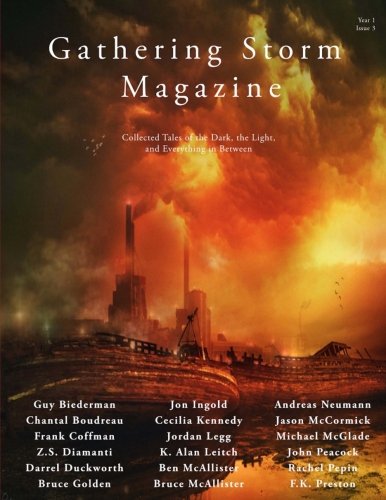
Gathering Storm Magazine, Year 1, Issue 3: Collected Tales of the Dark, the Light, and Everything in Between
Language: English
Published by Gathering Storm Magazine, 2017
ISBN 10: 0692906541 ISBN 13: 9780692906545
US$ 21.58
US$ 16.76 shipping
Ships from United Kingdom to U.S.A.Quantity: 1 available
Add to basketPaperback. Condition: Brand New. year 1, issue 3 edition. 74 pages. 11.00x8.50x0.18 inches. In Stock.
-
Automobile Map and Guide, Hotel Virginia, Long Beach "By the Sea" California [1920's California Road Map]
Published by Virginia Hotel, 1925
Seller: Epilonian Books, Manhattan Beach, CA, U.S.A.
Association Member: IOBA
Seller rating 5 out of 5 stars

Condition: Acceptable. Automobile Map and Guide issued by The Virginia Hotel, Long Beach "By the Sea" California. No date listed, circa 1925. Single sheet (16 x 10") folded into 8 panels (4 on each side). Folded sheet measures 4 x 10". In acceptable+ condition with a few 1" tears along edges of folds and a few smaller nicks and tears along edges. Light overall aging and soiling. One full side (4 panels) is a detailed driving map of Southern California which includes the Santa Monica and San Gabriel mountains to the northwest and Murrietta and Banning to the East. The undated map is copyrighted by Guy R. McHenry and includes the 1920 census figures beneath each city throughout. Two panels are black and white with red coloring photo reproduction of the entrance to the Hotel Virginia with a car and an attendant in front. 2 panels give detailed driving directions to various destinations, many "on paved or oiled roads all the way." An amazingly detailed snap shot of the road system in California during the mid 1920's. Hotel Virginia, located on the south side of Ocean Avenue at Magnolia, opened on April 1, 1908, and was the social center of the area for many years. Originally named the Bixby Hotel, it was renamed the Virginia Hotel after a construction accident in 1906 resulted in fatalities. The hotel did not survive the stock market crash of 1929 and closed on October 10, 1932. The building was demolished after the March 10, 1933 earthquake. The architects were John C. Austin and Frederick G. Brown. The landscape architect was Belle S. Angier. The hotel had six stories and two wings with a total of 400 rooms.
![Seller image for Automobile Map and Guide, Hotel Virginia, Long Beach "By the Sea" California [1920's California Road Map] for sale by Epilonian Books](https://pictures.abebooks.com/inventory/md/md31577320967.jpg)