

Order Total (1 Item Items):
Shipping Destination:

Hazleton H L (1 results)
Skip to main search results
Search filters
Product Type
- All Product Types
- Books (1)
- Magazines & Periodicals (No further results match this refinement)
- Comics (No further results match this refinement)
- Sheet Music (No further results match this refinement)
- Art, Prints & Posters (No further results match this refinement)
- Photographs (No further results match this refinement)
- Maps (No further results match this refinement)
- Manuscripts & Paper Collectibles (No further results match this refinement)
Condition Learn more
- New (No further results match this refinement)
- As New, Fine or Near Fine (No further results match this refinement)
- Very Good or Good (No further results match this refinement)
- Fair or Poor (No further results match this refinement)
- As Described (1)
Binding
- All Bindings
- Hardcover (No further results match this refinement)
- Softcover (No further results match this refinement)
Collectible Attributes
- First Edition (No further results match this refinement)
- Signed (No further results match this refinement)
- Dust Jacket (No further results match this refinement)
- Seller-Supplied Images (1)
- Not Print on Demand (1)
Language (1)
Price
- Any Price
- Under US$ 25 (No further results match this refinement)
- US$ 25 to US$ 50 (No further results match this refinement)
- Over US$ 50
Free Shipping
- Free Shipping to U.S.A. (No further results match this refinement)
Seller Location
Seller Rating
-
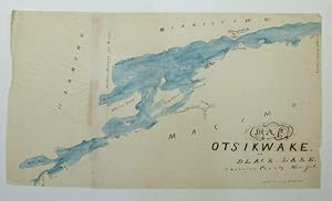
Map of Otsikwake or Black Lake, St. Lawrence County New York
Seller: Argosy Book Store, ABAA, ILAB, New York, NY, U.S.A.
Seller rating 5 out of 5 stars

Map. Pen and ink with watercolor. Image measures 13 x 23". This pen and ink map of Black Lake in New York State was likely produced in the mid-19th century by a student or apprentice as training in geography, drafting, and penmanship. The lake, otherwise known at Otsikwake, is located in St. Lawrence County near the Canadian border. Significant locales are labeled in a fashion redolent of printed maps of the period, yet the idiosyncratic handwriting of the mapmaker gives the map a more artistic quality. The blue wash of watercolor that colors the lake adds to the map's aesthetic qualities. The map is drawn on two pieces of paper glued together, with some red markings at the seam. It has some wrinkles and folds consistent with its hand-drawn format. Manuscript map-making was a useful educational tool in the 19th century, a period of imperialism and increased world trade in which geography grew significantly as a field of study. In the United States and northwestern Europe, reform movements that sought to improve the quality and accessibility of childhood education pushed for the inclusion of geography in school curricula. One common method of teaching was the making of manuscript maps. Working from wall maps, globes, and atlases, students were made to meticulously hand-reproduce maps in pen and ink and with watercolor. Such exercises not only provided a way to review and retain geographical knowledge, but they also functioned as training in penmanship, calligraphy, and drafting. Today, these idiosyncratic projects offer a glimpse into the way 19th-century youth engaged with the world around them.
