Hendrick Doncker (18 results)

Language: German
Published by Aufs Neue Nach 300 Jahren herausgegeben vom Veb Hinstorff Verlag Rostock, Leipzig 1969
- Softcover
- First Edition
Seller: Antiquariat Ottakring 1160 Wien, Wien, , AustriaAntiquariat Ottakring 1160 Wien
Contact seller5-star sellerCondition: Used - Very good
US$ 143.05
US$ 83.91 shippingShips from Austria to U.S.A.Quantity: 1 available
Softcover. Condition: Gut. 1. Auflage. Lizenzausgabe von Delius Klasing Vlg., 1. Aufl., 58cm x 49cm, je 10 farb. Karten, 1 Titelblatt u. 1 Einführung von Lothar Eich lose in orig. Karton Mappe (Umshclag Siegfried Berning), Band I: Mappe mit geringen Randläs., Band I u. II: Blätter tadellos, insg. guter Zustand.

- Hardcover
- Print on Demand
Seller: True World of Books, Delhi, , IndiaTrue World of Books
Contact seller5-star sellerLeatherBound. Condition: New. BOOKS ARE EXEMPT FROM IMPORT DUTIES AND TARIFFS; NO EXTRA CHARGES APPLY. LeatherBound edition. Condition: New. Reprinted from 1665 edition. Leather Binding on Spine and Corners with Golden leaf printing on spine. Bound in genuine leather with Satin ribbon page markers and Spine with raised gilt band…s. A perfect gift for your loved ones. Pages: 148 NO changes have been made to the original text. This is NOT a retyped or an ocr'd reprint. Illustrations, Index, if any, are included in black and white. Each page is checked manually before printing. As this print on demand book is reprinted from a very old book, there could be some missing or flawed pages, but we always try to make the book as complete as possible. Fold-outs, if any, are not part of the book. If the original book was published in multiple volumes then this reprint is of only one volume, not the whole set. Sewing binding for longer life, where the book block is actually sewn (smythe sewn/section sewn) with thread before binding which results in a more durable type of binding. Pages: 148.

Published by Amsterdam 1668
Seller: Libreria Pontes, Madrid, M, SpainLibreria Pontes
Contact seller5-star sellerCondition: Used - Very good
US$ 1,668.87
US$ 16.78 shippingShips from Spain to U.S.A.Quantity: 1 available
Sin Encuadernar. Condition: Bien. Doncker was a bookseller and printer of sea charts in Amsterdam for over fifty years.The difference of the Doncker´s charts is that were his own work and were noted for the accuracy and improvement that showed in comparison with other cartographic material that other cartographers copied each ot…her. The stock of Doncker was sold eventually to Johannes Van Keulen.

Published by Amsterdam 1668
Seller: Libreria Pontes, Madrid, M, SpainLibreria Pontes
Contact seller5-star sellerCondition: Used - Very good
US$ 1,430.46
US$ 16.78 shippingShips from Spain to U.S.A.Quantity: 1 available
Sin Encuadernar. Condition: Bien. Double page engraved sea chart. 57x45 cms. Black and white.Compass rose, scales, title cartouche in upper left side,rhumb lines. Bottom margin trimmed at central fold.Very light foxing., The chart was originally reinforced with double paper leaf. This chart comes from a rare and unrecorded varia…nt not traced in Koeman (french edition 1668) The area ciovers the Antilles ,Trinidad,Tobago, Barbados and Puerto Rico at the upper right side.Northern paart of nowadays Venezuela is also reDoncker was a bookseller and printer of sea charts in Amsterdam for over fifty years.The difference of the Doncker´s charts is that were his own work and were noted for the accuracy and imporvement that showed in comparison with other cartographic material that other cartographers copied each other. The stock of Doncker was sold eventually to Johannes Van Keulen.

Published by Amsterdam 1668
Seller: Libreria Pontes, Madrid, M, SpainLibreria Pontes
Contact seller5-star sellerCondition: Used - Very good
US$ 1,907.28
US$ 16.78 shippingShips from Spain to U.S.A.Quantity: 1 available
Sin Encuadernar. Condition: Bien. Double page engraved sea chart.55x 47 cms. Black and white. Scales, rhumb lines,compass roses, cartouche with decorative design. The Greenwich meridian in the middle of the chart. The map has been carefully restored to erase foxing. reinforced with its original double paper leaf. The chart comes… from an unrecorded issue of the french edition of the Doncker atlas(not listed in Koeman). Doncker was a bookseller and printer of sea charts in Amsterdam for over fifty years.The difference of the Doncker´s charts is that were his own work and were noted for the accuracy and imporvement that showed in comparison with other cartographic material that other cartographers copied each other. The stock of Doncker was sold eventually to Johannes Van Keulen.

Published by Amsterdam 1668
Seller: Libreria Pontes, Madrid, M, SpainLibreria Pontes
Contact seller5-star sellerCondition: Used - Very good
US$ 1,609.27
US$ 16.78 shippingShips from Spain to U.S.A.Quantity: 1 available
Sin Encuadernar. Condition: Bien. Double page engraved sea chart. 55x 47 cms. Black and white. Compass rose,scales, rhumb lines,large cartouche with figures. The chart has been expertly restored to clean the foxing. The chart preserves its original double paper leaf. The map represents the Northern sea with england eastern coast… and Scandinavian countries western coast. Thye chart comes from a rare and unrecorded french issue of the Doncker atlas not traced in Koeman bibliography.

Published by Amsterdam 1668
Seller: Libreria Pontes, Madrid, M, SpainLibreria Pontes
Contact seller5-star sellerCondition: Used - Very good
US$ 715.23
US$ 16.78 shippingShips from Spain to U.S.A.Quantity: 1 available
Sin Encuadernar. Condition: Bien. Double page engraved sea chart. 55 x 47 cms. Black and white. Scales, rhumb lines and compass roses. Light foxing at the lower part of the chart. Reinforced originally with double paper leaf. The chart comes from an unrecorded french issue not listed in Koeman Doncker was a bookseller and printe…r of sea charts in Amsterdam for over fifty years.The difference of the Doncker´s charts is that were his own work and were noted for the accuracy and imporvement that showed in comparison with other cartographic material that other cartographers copied each other. The stock of Doncker was sold eventually to Johannes.

Published by Amsterdam 1668
Seller: Libreria Pontes, Madrid, M, SpainLibreria Pontes
Contact seller5-star sellerCondition: Used - Very good
US$ 715.23
US$ 16.78 shippingShips from Spain to U.S.A.Quantity: 1 available
Sin Encuadernar. Condition: Bien. Double page engraved sea chart.57x 45 cms. Black and white; compass roses, scales,loxodromical lines, depth marks.Some very light spotting. Double paper leaf.This sea chart comes from a rare variant not recorded by Koeman(french edition dated 1668) The chart covers the Brittany and Normandy shor…es and southern England.

Published by Amsterdam 1668
Seller: Libreria Pontes, Madrid, M, SpainLibreria Pontes
Contact seller5-star sellerCondition: Used - Near fine
US$ 1,907.28
US$ 16.78 shippingShips from Spain to U.S.A.Quantity: 1 available
Sin Encuadernar. Condition: Muy bien. Double page engraved sea chart. 55x 47 cms. Black and white. Rhumb lines, scales and compass roses. Cartouche with figures shown using astronomical instruments.Very light foxing in upper right side.The chart preserves its original double paper leaf. The chart comes from an unrecorded french…issue of Doncker´s sea atlas not listed in Koeman Doncker was a bookseller and printer of sea charts in Amsterdam for over fifty years.The difference of the Doncker´s charts is that were his own work and were noted for the accuracy and imporvement that showed in comparison with other cartographic material that other cartographers copied each other. The stock of Doncker was sold eventually to Johannes Van Keulen.
Published by c. 1678, Amsterdam 1678
- Map
Seller: Alexandre Antique Prints, Maps & Books, Toronto, ON, CanadaAlexandre Antique Prints, Maps & Books
Contact seller4-star sellerCondition: Used
US$ 2,500.00
US$ 6.00 shippingShips from Canada to U.S.A.Quantity: 1 available
This is the second state of Doncker's map, first published in 1678 in his 'Zee-Atlas', which makes one improvement on the first state: it depicts the Grand Bank as much larger and indicates depth soundings. (Kershaw Pl. 114)The map, like the majority of Dutch maps of the Canadian maritimes of the era, is nearly exactly copied fr…om Van Loon's map. Van Loon in turn relied heavily on earlier Dutch sources, including Gerritz and Blaeu, which accounts for the shape of Newfoundland and Cape Breton. The omission of Prince Edward Island is due to a heavy reliance on Champlain's maps of the Canadian mainland, which did not depict the island. , Size : 430x520 (mm), 16.93x20.47 (Inches), Hand Colored in Outline, 0 Very Good; lower margin extended.
Language: German
Published by Bielefeld und Berlin, Delius Klasing, 1969-`70. 1969
Seller: Antiquariat Langguth - lesenhilft, Köln, , GermanyAntiquariat Langguth - lesenhilft
Contact seller4-star sellerCondition: Used
US$ 154.97
US$ 18.52 shippingShips from Germany to U.S.A.Quantity: 1 available
2 Bll., 20 kolorierte Tafeln. Einführungstext von Lothar Eich. Gute Exemplare. Sprache: Deutsch Gewicht in Gramm: 5000 Lose Tafeln in Orig.-Pappmappe (Umschlag: Siegfried Berning).
 More images
- Hardcover
- Print on Demand
Seller: Gyan Books Pvt. Ltd., Delhi, , IndiaGyan Books Pvt. Ltd.
Contact seller5-star sellerCondition: New
US$ 38.45
Free ShippingShips from India to U.S.A.Quantity: Over 20 available
Leather Bound. Condition: New. Language: Dutch. Language: Dutch_Flemish. Presenting an Exquisite Leather-Bound Edition, expertly crafted with Original Natural Leather that gracefully adorns the spine and corners. The allure continues with Golden Leaf Printing that adds a touch of elegance, while Hand Embossing on the rounded spi…ne lends an artistic flair. This masterpiece has been meticulously reprinted in 2024, utilizing the invaluable guidance of the original edition published many years ago in 1665. The contents of this book are presented in classic black and white. Its durability is ensured through a meticulous sewing binding technique, enhancing its longevity. Imprinted on top-tier quality paper. A team of professionals has expertly processed each page, delicately preserving its content without alteration. Due to the vintage nature of these books, every page has been manually restored for legibility. However, in certain instances, occasional blurriness, missing segments, or faint black spots might persist. We sincerely hope for your understanding of the challenges we faced with these books. Recognizing their significance for readers seeking insight into our historical treasure, we've diligently restored and reissued them. Our intention is to offer this valuable resource once again. We eagerly await your feedback, hoping that you'll find it appealing and will generously share your thoughts and recommendations. Lang: - Dutch,Flemish, Pages: : - 148, Print on Demand. If it is a multi-volume set, then it is only a single volume. We are specialised in Customisation of books, if you wish to opt different color leather binding, you may contact us. This service is chargeable. Product Disclaimer: Kindly be informed that, owing to the inherent nature of leather as a natural material, minor discolorations or textural variations may be perceptible. Explore the FOLIO EDITION (12x19 Inches): Available Upon Request. 148 148.

- Map
Seller: Geographicus Rare Antique Maps, Brooklyn, NY, U.S.A.Geographicus Rare Antique Maps
Contact seller4-star sellerVery good. Light, even toning. Marginal mend well away from printed image. Else excellent with original outline color. Size 15.25 x 20 Inches. This is Hendrick Doncker's rare c. 1669 chart of the Balearic Islands, portraying the islands of Majorca, Minorca, and Ibiza (Ibiça). The chart includes part of the Mediterranean coast of… Spain, from C. St. Martin on the coast of Valencia to the Cap de Creus on the coast of Catalonia. A Closer Look The chart is oriented to the northwest. (An apparent aesthetic choice, allowing the presentation of the coastline and primary islands more or less in line horizontally.) Majorca, Minorca, Ibiza, and Formentera are presented in outline, as are the smaller islands of Cabrera, Dragonera, and Monte Colibre - the Columbretes Islands. The coast of Valencia and Catalonia dominates the top part of the chart. All coastlines are delineated in pictorial coastal profiles; the sea is presented in the manner of a chart, with an attractive compass rose and rhumb lines. The chart includes depth soundings and anchorages on several points of each of the islands, and along the Spanish coast. At the upper right, the Gulf of Roses appears, with depth soundings and an anchorage. The State of the Art The Balearic Island maps of Blaeu and Jansson, and the Sanson of the middle part of the 17th century, had all derived largely from the 1612 mapping of Hessel Gerrritsz; the present chart represents a fascinating departure from that model, not less because the source of the new navigational information appearing here is not clear. The presence of the depth soundings and anchorages strongly suggests a firsthand source providing data to the Amsterdam chartmaker. Publication History and Census This chart was engraved by Hendrick Doncker; the few cataloged examples have been variously dated, the earliest (unsupported) date being 1659. We do not see any examples included in his Zee-Atlas ofte Water-Werelt prior to 1669. We see only two auction records for the chart over the past 40 years, and there are no examples cataloged in OCLC. References: Not in OCLC.
 More images
Language: German
- Art Print
Seller: Kunstantiquariat Andreas Senger, Hamburg, , GermanyKunstantiquariat Andreas Senger
Contact seller5-star sellerCondition: Used - Near fine
US$ 2,849.00
US$ 40.51 shippingShips from Germany to U.S.A.Quantity: 1 available
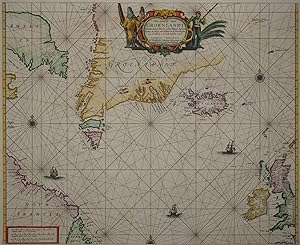
Kein Einband. Condition: Gut bis sehr gut. Es handelt sich hierbei um eine originale, altkolorierte Kupferstichlandkarte des Nordatlantiks und seiner Küstengebiete von Hendrick Doncker aus dem Jahr 1660. *** Titel: Pas-Caerte van Groenlandt, Yslandt, Straet Davids en Ian Mayen Eylant; Hoemen de Selvige van Hitlant en de Noord Ku…sten van Schotlandt en Yrlandt Beseylen mach *** Gebiet bzw. Ort: Die Karte zeigt den Nordatlantik nördlich einer Linie Neufundland - Paris. Von Neufundland im Westen über die Hudson Bay / Nordwestpassage, Grönland und Island im Zentrum bis nach Großbritannien im Osten. *** Kartograph: Hendrick Doncker (1626 - 1699) *** Jahr: 1660 *** Größe des Plattenbereichs: 43 x 52 cm *** Technik: Kupferstich *** Zustand (Perfekt/ Sehr gut/ Gut/ Ordentlich/ Mäßig/ Schlecht): In sehr gutem Erhaltungszustand. Altersgemäß leicht gebräunt. *** Bemerkungen: Sehr seltene, altkolorierte Seekarte des Nordatlantiks. Der Kartenbereich reicht von Neufundland im Westen über die Hudson Bay / Nordwestpassage, Grönland und Island im Zentrum bis nach Großbritannien im Osten. Die Kartendarstellung wird ergänzt durch eine aufwendige figürliche Kartusche (zwei Lapländer mit Kajak und ein niederländischer Walfänger mit Harpune), Segelschiffe, Kompassrosen und Rhumbenlinien im Stil einer mittelalterlichen Portolankarte. Diese dekorative und sehr detaillierte Karte in ausdrucksstarkem Altkolorit entstammt der äußerst seltenen ersten Auflage des 'Zee Atlas Ofte Water Waereld' von Hendrick Doncker. - - - International buyers welcome. If you have any questions, please don't hesitate to ask. --- Auf Wunsch stellen wir Ihnen gerne ein kostenfreies Echtheitszertifikat aus --- If you wish, we will gladly provide a certificate of authenticity free of charge ---.
 More images
Language: German
- Art Print
Seller: Kunstantiquariat Andreas Senger, Hamburg, , GermanyKunstantiquariat Andreas Senger
Contact seller5-star sellerCondition: Used - Near fine
US$ 2,968.21
US$ 40.51 shippingShips from Germany to U.S.A.Quantity: 1 available
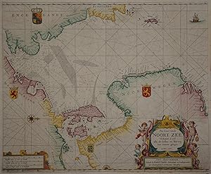
Kein Einband. Condition: Gut bis sehr gut. Es handelt sich hierbei um eine originale, altkolorierte Kupferstichlandkarte des Nordseeraumes von Hendrick Doncker aus dem Jahr 1664. *** Titel: Pas Caart van de Noort Zee Verthoonende in zich alle de Custen en Havens daer rontom gelegen. *** Gebiet bzw. Ort: Die westorientierte Karte… zeigt die Nordsee vom Ärmelkanal bis nördlich der Shetland Inseln, dazu einen Teil des Ostseeraumes bis östlich von Bornholm. Detaillierte Darstellung der Küstengebiete von Großbritannien, Norwegen, Schweden, Dänemark, Deutschland und der Niederlande. *** Kartograph: Hendrick Doncker (1626 - 1699) *** Jahr: 1664 *** Größe des Plattenbereichs: 43 x 53 cm *** Technik: Kupferstich *** Zustand (Perfekt/ Sehr gut/ Gut/ Ordentlich/ Mäßig/ Schlecht): In sehr gutem Erhaltungszustand. Altersgemäß leicht gebräunt. *** Bemerkungen: Sehr seltene, altkolorierte Seekarte des Nordseeraumes. Der Kartenbereich erstreckt sich vom Ärmelkanal bis nördlich der Shetland Inseln, dazu zeigt er auch einen Teil des Ostseeraumes bis östlich von Bornholm. Detaillierte Darstellung der Küstengebiete von Großbritannien, Norwegen, Schweden, Dänemark, Deutschland und der Niederlande sowie Einzeichnung der bekannten Untiefen. Die Kartendarstellung wird ergänzt durch eine aufwendige, von vier Putti umrahmte, Kartusche, ein Segelschiff, Kompassrosen und Rhumbenlinien im Stil einer mittelalterlichen Portolankarte. Äußerst seltenes Exemplar aus der Erstauflage dieser Seekarte in dekorativem Altkolorit. - - - International buyers welcome. If you have any questions, please don't hesitate to ask. --- Auf Wunsch stellen wir Ihnen gerne ein kostenfreies Echtheitszertifikat aus --- If you wish, we will gladly provide a certificate of authenticity free of charge ---.
 More images
Language: German
- Map
Seller: Kunstantiquariat Andreas Senger, Hamburg, , GermanyKunstantiquariat Andreas Senger
Contact seller5-star sellerCondition: Used - Near fine
US$ 1,786.89
US$ 40.51 shippingShips from Germany to U.S.A.Quantity: 1 available
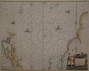
Kein Einband. Condition: Gut bis sehr gut. Es handelt sich hierbei um eine originale, altkolorierte Kupferstichlandkarte des südlichen Teils Südamerikas von Hendrick Doncker aus dem Jahr 1659. *** Titel: Paskaarte van't zuijdelijckste Deel van America. van Cabo St. Antonio, tot Caep de Hoorn, ende inde Zuij Zee, tot B. de Tongoi…j. *** Gebiet bzw. Ort: Südspitze Südamerikas. Zeigt das Gebiet südlich einer Linie Santiago de Chile - Buenos Aires: Große Teile Argentiniens und Chiles mit Feuerland, Patagonien, Kap Hoorn und der Magellanstraße. *** Kartograph: Hendrick Doncker (1626 - 1699) *** Jahr: 1659 *** Größe des Plattenbereichs: 43 x 54 cm *** Technik: Kupferstich *** Zustand (Perfekt/ Sehr gut/ Gut/ Ordentlich/ Mäßig/ Schlecht): In sehr gutem Erhaltungszustand. Altersgemäß leicht gebräunt. *** Bemerkungen: Sehr seltene, altkolorierte Seekarte des südlichen Teils Südamerikas. Der Kartenbereich umfasst das Gebiet südlich einer Linie Santiago de Chile - Buenos Aires: Große Teile Argentiniens und Chiles mit Feuerland, Patagonien, Kap Hoorn und der Magellanstraße. Die Darstellung wird ergänzt um eine schöne Rollwerkkartusche, getragen von zwei Putti, Segelschiffe, eine Kompassrose und Rhumbenlinien im Stil einer mittelalterlichen Portolankarte. Diese dekorative und sehr detaillierte Karte in ausdrucksstarkem Altkolorit entstammt der seltenen ersten Auflage des 'Zee-Atlas'. - - - International buyers welcome. If you have any questions, please don't hesitate to ask. - - - Argentinia Chili Chilli Patagonia Tierra del Fuego Fireland Magellan's Cross ----- Auf Wunsch stellen wir Ihnen gerne ein kostenfreies Echtheitszertifikat aus ------ If you wish, we will gladly provide a certificate of authenticity free of charge ---.
 More images
Language: German
- Map
Seller: Kunstantiquariat Andreas Senger, Hamburg, , GermanyKunstantiquariat Andreas Senger
Contact seller5-star sellerCondition: Used - Near fine
US$ 2,382.91
US$ 40.51 shippingShips from Germany to U.S.A.Quantity: 1 available
Kein Einband. Condition: Gut bis sehr gut. Es handelt sich hierbei um eine originale, altkolorierte Kupferstichlandkarte der Barentssee von Hendrick Doncker aus dem Jahr 1664. *** Titel: Pascaart van de Zee-Custen van Ruslant, Laplant, Finmarcken, Spitsbergen en Nova-zemla *** Gebiet bzw. Ort: Die Karte zeigt die Barentssee mit…den detaillierten Küstengebieten von Russland, Finnland, Norwegen, Spitzbergen *** Kartograph: Hendrick Doncker (1626 - 1699) *** Jahr: 1658 *** Größe des Plattenbereichs: 43 x 55 cm *** Technik: Kupferstich *** Zustand (Perfekt/ Sehr gut/ Gut/ Ordentlich/ Mäßig/ Schlecht): In sehr gutem Erhaltungszustand. Altersgemäß leicht gebräunt. *** Bemerkungen: Sehr seltene, altkolorierte Seekarte des Gebiets der Barentssee. Der Kartenbereich erstreckt sich vom nördlichen Norwegen über das Nordkap bis Nova Zemla. Detaillierte Darstellung der Küstengebiete von Russland, Finnland, Norwegen und Spitzbergen sowie Einzeichnung einiger bekannter Untiefen. Die Kartendarstellung wird ergänzt durch eine aufwendige Kartusche, eine kleine Insetkarte von Archangelsk, zwei Segelschiffe, Kompassrosen und Rhumbenlinien im Stil einer mittelalterlichen Portolankarte. Äußerst seltene Seekarte in dekorativem Altkolorit. ---International buyers welcome. If you have any questions, please don't hesitate to ask. ---.
 More images
Language: German
- Map
Seller: Kunstantiquariat Andreas Senger, Hamburg, , GermanyKunstantiquariat Andreas Senger
Contact seller5-star sellerCondition: Used - Near fine
US$ 2,372.18
US$ 40.51 shippingShips from Germany to U.S.A.Quantity: 1 available
Kein Einband. Condition: Gut bis sehr gut. Es handelt sich hierbei um eine originale, altkolorierte Kupferstichlandkarte der Ostküste Nord- und Südamerikas von Hendrick Doncker aus dem Jahr 1660. *** Titel: Pascaerte van Brazil en Niev Neder Landt, van Corvo en Flores tot de Barbados¿ *** Gebiet bzw. Ort: Die Ostküste von Nord-…und Südamerika. Von Neufundland über Nova Scotia, die Neuenglandstaaten der USA (hier 'Nieu Nederlant' benannt), New York bis nach North Carolina. Die östliche Karibik mit Kuba und Puerto Rico. Venezuela und die brasilianische Küste etwa bis zum heutigen Recife. Zeigt darüber hinaus im Osten die Inselgruppen der Azoren und Kanaren. *** Kartograph: Hendrick Doncker (1626 - 1699) *** Jahr: 1660 *** Größe des Plattenbereichs: 43 x 52 cm *** Technik: Kupferstich *** Zustand (Perfekt/ Sehr gut/ Gut/ Ordentlich/ Mäßig/ Schlecht): In sehr gutem Erhaltungszustand. Altersgemäß leicht gebräunt. *** Bemerkungen: Sehr seltene, altkolorierte Seekarte der Ostküste von Nord- und Südamerika. Der Kartenbereich reicht von Neufundland in Kanada über Nova Scotia, die Neuenglandstaaten der USA und New York bis nach North Carolina. Daran anschließend sind die östliche Karibik mit Kuba und Puerto Rico dargestellt. Die südamerikanische Küste wird von Venezuela bis zum Gebiet des heutigen Recife in Brasilien gezeigt. Im Osten des Atlantiks sind die Inselgruppen der Azoren und Kanaren zu erkennen. Die ostorientierte Kartendarstellung wird ergänzt durch eine aufwendige figürliche Kartusche, Segelschiffe, Kompassrosen und Rhumbenlinien im Stil einer mittelalterlichen Portolankarte. Diese dekorative und sehr detaillierte Karte in ausdrucksstarkem Altkolorit entstammt der äußerst seltenen ersten Auflage des 'Zee Atlas Ofte Water Waereld' von Hendrick Doncker. -- Burden, America 338, state 1. - - - International buyers welcome. If you have any questions, please don't hesitate to ask. - - - America Brazil US USA Eastcoast East coast new netherlands americas sea chart ----- Auf Wunsch stellen wir Ihnen gerne ein kostenfreies Echtheitszertifikat aus ------ If you wish, we will gladly provide a certificate of authenticity free of charge ---.


