Order Total (1 Item Items):
Shipping Destination:

Henry Abraham Chatelain (20 results)
Skip to main search results
Search filters
Product Type
- All Product Types
- Books (8)
- Magazines & Periodicals (No further results match this refinement)
- Comics (No further results match this refinement)
- Sheet Music (No further results match this refinement)
- Art, Prints & Posters (7)
- Photographs (No further results match this refinement)
- Maps (5)
- Manuscripts & Paper Collectibles (No further results match this refinement)
Condition Learn more
- New (No further results match this refinement)
- As New, Fine or Near Fine (1)
- Very Good or Good (3)
- Fair or Poor (No further results match this refinement)
- As Described (16)
Binding
- All Bindings
- Hardcover (1)
- Softcover (No further results match this refinement)
Collectible Attributes
- First Edition (1)
- Signed (No further results match this refinement)
- Dust Jacket (No further results match this refinement)
- Seller-Supplied Images (18)
- Not Print on Demand (20)
Language (1)
Price
- Any Price
- Under US$ 25 (No further results match this refinement)
- US$ 25 to US$ 50 (No further results match this refinement)
- Over US$ 50
Free Shipping
- Free Shipping to U.S.A. (No further results match this refinement)
Seller Location
Seller Rating
-
Condition: Buono (Good). acquaforte inciso cm. 47,3 x 38,7 Buono (Good) Buon es. Book.
-

L'Idee Generale du Conclave de Lexaltation des Papes de Leur Pompe Funebred et des Diferentes Iudictions de la Cour de Rome
Published by Paris [1718], Paris, 1718
Seller: High Ridge Books, Inc. - ABAA, South Deerfield, MA, U.S.A.
Association Member: ABAA ESA ILAB SNEAB
Seller rating 5 out of 5 stars

33x44 cm. (image size), 48x56 cm. (paper size). Uncolored. Excellent condition. Multiple images surrounding text, all related to the Vatican and the College of Cardinals' proceedings to elect a new pope. There is a plan of the Vatican, view of St. Peter's, image of the assemblage of the Conclave of Cardinals, a depiction of a papal procession and six small images of the steps taken in the election of a pope.
-
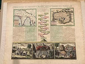
Genealogie des Empereurs Mogols Depuis Tamerlan ou Tamerlan
Published by Chatelain, Henry Abraham (1684-1743), 1708
Map
No Binding. Condition: Very Good. This is magnificent copper engraving taken from Chatelain"s Atlas Historique published in Amsterdam between 1705 and 1720. The Atlas newly combined maps and engravings with information on geography, history, ethnology and heraldry. This copper engraving contains a pair of maps as well as a Genealogical tree and 3 indigenous vies of the Moghal Empire. The upper maps show the Empire of the Great Mogol and the Kingdon of Kachimere. The centre panel shows a tree of the Mogol Dynasty, beginning with Tamberlan in 1402 and ending with Ferrog Sier. At the bottom, are three engraved views showing indigenous scenes of the Mogog Empire, including two combatants on elephants, a scene in the Royal Court, and the custom of Burning the Dead. NOTE there is a chip in the top right hand corner of the engraving - see photograph.
-
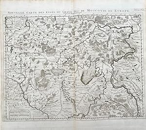
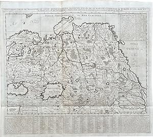
Nouvelle carte des Etats du Grand Duc de Moscovie en Europe. Partie Meriodonale.
Published by Amsterdam: Les Fr� res Chatelain, [1720], 1720
Seller: Michael S. Kemp, Bookseller, Sheerness, KENT, United Kingdom
Association Member: PBFA
Seller rating 5 out of 5 stars
Map
US$ 192.29
US$ 53.34 shipping
Ships from United Kingdom to U.S.A.Quantity: 1 available
Add to basketDouble page map, 440 x 495 mm. From the Atlas Historique [1708 - 1720] Volume 4, plate 31.
-
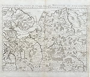
Nouvelle carte des Etats du Grand Duc de Moscovie en Europe. Partie Sertontrionale.
Published by Amsterdam: Les Fr� res Chatelain, [1720], 1720
Seller: Michael S. Kemp, Bookseller, Sheerness, KENT, United Kingdom
Association Member: PBFA
Seller rating 5 out of 5 stars
Map
US$ 192.29
US$ 53.34 shipping
Ships from United Kingdom to U.S.A.Quantity: 1 available
Add to basketDouble page map, 440 x 495 mm. From the Atlas Historique [1708 - 1720] Volume 4, plate 30.
-
Nouvelle carte de Moscovie o� sont Retresent� s les Diferents Etats de sa Majest� Czarienne en Europe et en Asie et les chemins d'un de ses Ambassadeurs a Peking Ville Capitasl de l'Empereur de la Chine et son Sejour Ordinaire.
Published by Amsterdam: Les Fr� res Chatelain, [1720], 1720
Seller: Michael S. Kemp, Bookseller, Sheerness, KENT, United Kingdom
Association Member: PBFA
Seller rating 5 out of 5 stars
Map
US$ 192.29
US$ 53.34 shipping
Ships from United Kingdom to U.S.A.Quantity: 1 available
Add to basketDouble page map, 540 x 610 mm. From the Atlas Historique [1708 - 1720] Volume 4, plate 20.
-
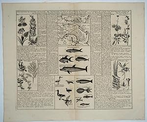
Description De L'Isthme De Darien Des Proprietez Du Pais Et De La Ville De Panama; A La Quelle On A Joint Une Description Curieuse Des Diverses Plantes, Oiseaux, Poissons Les Plus Rares Qui Se Trouvent Dans La Nouvelle Hollande. / Carte De L'Isthme De Darien Et Du Golfe De Panama
Published by Paris, 1721
Seller: Antipodean Books, Maps & Prints, ABAA, Garrison, NY, U.S.A.
Association Member: ABAA ANZAAB ESA ILAB
Seller rating 3 out of 5 stars

From the Australian point of view, most interesting for the illustrations drawn from Dampier's explorations on the West Australian coast, particularly the images of fish, birds, squid & plants, the first images of Australian fauna & flora to be seen by the Western world. It includes extensive text describing the natural history found there, in French. His account of the expedition was published as "A Voyage to New Holland" in 1703. Dampier is regarded by many as Australia's first natural historian. The three maps at the top of the plate are of the Isthmus of Darien and the Gulf of Panama. Size : 370x433 (mm), 14.57x17.05 (Inches). Many of the maps are based on the work of Guillaume de l'Lisle. Published in Chatelain's "Atlas Historique, ou nouvelle introduction a l'histoire, a la chronologie & a la geographie ancienne & moderne" in Amsterdam 1721. Many of the maps are based on the work of Guillaume de l'Lisle. Copperplate engraving, 14.5 x17". Full impression mark with wide margins. Some slight bends in margin, fine overall.
-
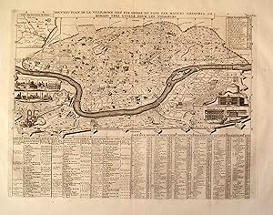
Noveau Plan de la Ville de Rome Tire par Ordre du Pape par Matteo Gregoira de Romans Tres Utille pour les Voiageurs
Published by Paris c. 1705, Paris, 1705
Seller: High Ridge Books, Inc. - ABAA, South Deerfield, MA, U.S.A.
Association Member: ABAA ESA ILAB SNEAB
Seller rating 5 out of 5 stars
Uncolored map of modern Rome. fine condition. Extensive tables showing locations of buildings, statues and pieces of art around the city. Small vignettes of 10 buildings, inset map of the environs of Rome.
-
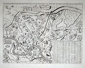
Roma Vetus
Published by Paris c. 1705, Paris, 1705
Seller: High Ridge Books, Inc. - ABAA, South Deerfield, MA, U.S.A.
Association Member: ABAA ESA ILAB SNEAB
Seller rating 5 out of 5 stars
Uncolored map of Rome during the Empire. fine condition with wide margins. Secondary title at top: "Plan des Antiquitez de Rome Representes et Distingues Suivant la Situation de Chacun de ses Anciens Monuments." Extensive index of 196 buildings at bottom right.
-

Carte pour servir de secours a la connoissance des medailles anqitues des empereurs romains jusqu'? Heraclius
Published by Amsterdam,, 1710
Seller: libreria antiquaria perini Sas di Perini, Verona, VR, Italy
Seller rating 5 out of 5 stars
Art / Print / Poster
Incisione in rame, mm 490x580 (inciso), mm 565x650 (foglio). Tratta da "Atlas Historique". Illustra tutti i ritratti degli imperatori romani da Cesare, a Heraclio, talvolta con le rispettive consorti. Esemplare in ottimo stato di conservazione.
-
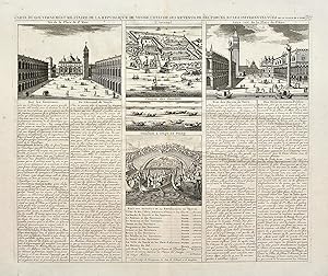
Carte du governement militaire de la republique de Venise, l�etat de ses revenus, de ses forces et les differentes vu�s.
Published by Amsterdam, 1710
Seller: libreria antiquaria perini Sas di Perini, Verona, VR, Italy
Seller rating 5 out of 5 stars
Art / Print / Poster
Incisione in rame, mm 390x470. Tratta da "Atlas Historique�. Con cinque riquadri con vedute di piazza San Marco (2), l�arsenale, una regata di gondole e il combattimento al ponte dei pugni. Il testo descrive la Repubbblica in generale, tratta dell�arsenale, delle ricchezze, dell�esercito e delle feste pubbliche. Esemplare in ottimo stato di conservazione. Nr.cat: cod 1520.
-
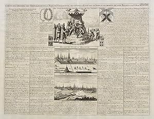
Carte des ordres de chevalerie de sa Majest� Czarienne, ses titres, l�Etat de sa noblesse, profil de son palais et la vue de Moscow
Published by Amsterdam, 1710
Seller: libreria antiquaria perini Sas di Perini, Verona, VR, Italy
Seller rating 5 out of 5 stars
Art / Print / Poster
Incisione in rame, mm 345x450 (foglio) con tre riquadri di circa mm 100x150 raffiguranti lo Zar, il palazzo e la citt? di Mosca. Tratta da "Atlas Historique�. Il testo descrive le famiglie nobili e lo stato della nobilt? russa. Esemplare in ottimo stato di conservazione. Nr.cat: Cod 1983.
-
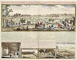
Vue et description de Bethleem et de Nazareth et de plusieurs singularitez curieuses sevoyents dans ces lieux saints.
Published by Amsterdam, 1708
Seller: libreria antiquaria perini Sas di Perini, Verona, VR, Italy
Seller rating 5 out of 5 stars
Art / Print / Poster
Incisione in rame, colorata, mm 375x493. Veduta generale con quattro particolari nelle vignette, illustrato da un accurato testo; tratta dal "Atlas Historique". Bell'esemplare. Copper engraving, coloured, 375x493. General view with 4 vignettes, illustrated by the text. From "Atlas historique". Nice example. Nr.cat: 4609.
-
Description De L'Isthme De Darien Des Proprietez Du Pais Et De La Ville De Panama; A La Quelle On A Joint Une Description Curieuse Des Diverses Plantes, Oiseaux, Poissons Les Plus Rares Qui Se Trouvent Dans La Nouvelle Hollande. / Carte De L'Isthme De Darien Et Du Golfe De Panama
Published by c.1719, Paris, 1719
Seller: Alexandre Antique Prints, Maps & Books, Toronto, ON, Canada
Seller rating 4 out of 5 stars

Map
Condition: Very Good. Three maps covering the Isthmus of Darien and the Gulf of Panama. It is illustrated with seven panels of finely engraved examples of the region's flora and fauna, including fish, birds and plant life., Size : 370x433 (mm), 14.57x17.05 (Inches), Hand Colored.
-
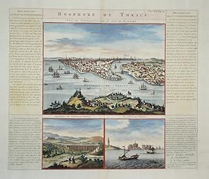
Bosphore de Thrace. Vue de Costantinople du cot� du Bosphore.
Published by Amsterdam,, 1710
Seller: libreria antiquaria perini Sas di Perini, Verona, VR, Italy
Seller rating 5 out of 5 stars
Art / Print / Poster
Incisione in rame, mm 370x435, colorata; bella veduta della Istanbul storica e del Corno d'Oro visti da oriente entro riquadro grande sotto al titolo. Sotto vi sono altri due riquadri pi? piccoli raffiguranti l'acquedotto e le colonne di Pompeo. Ai lati il testo esplicativo. Tratta da "Atlas Historique", tomo V.Esemplare in ottimo stato di conservazione. Nr.cat: P5280035.
-
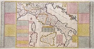
Nouvelle carte de l'etat present de l'Italie pour parvenir par une methode nouvelle, a la connoissance de la geographie�
Published by Amsterdam,, 1710
Seller: libreria antiquaria perini Sas di Perini, Verona, VR, Italy
Seller rating 5 out of 5 stars
Art / Print / Poster
Incisione in rame, mm 335x650, colorata a mano, raffigurante l'Italia intera al centro, circondata da numerosi riquadri con testo storico esplicativo delle varie regioni; tratta da "Atlas Historique".Esemplare in ottimo stato di conservazione. Nr.cat: P5280041.
-
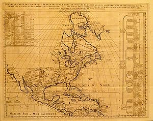
Nouvelle Carte de L'Amerique Septentrionale Dressee sur les Plus Nouvelles Observations .
Published by Paris c. 1708, Paris, 1708
Seller: High Ridge Books, Inc. - ABAA, South Deerfield, MA, U.S.A.
Association Member: ABAA ESA ILAB SNEAB
Seller rating 5 out of 5 stars
Very fine uncolored map of North America, including California. Minor foxing, one pinhole at fold junction.
-

Mappe-Monde pour Connoitre les Progres & les Conquestes les Plus Remarquables des Provinces-Unies, ainsy que celles des Compagnies d'Orient et d'Occident, et les Pais quelles Possedent dans l'un et dans l'autre Hemisphere
Published by Amsterdam, 1705
Seller: Antipodean Books, Maps & Prints, ABAA, Garrison, NY, U.S.A.
Association Member: ABAA ANZAAB ESA ILAB
Seller rating 3 out of 5 stars
Unusual double-hemisphere map of the world, illustrating the success of the Dutch East and West India Companies throughout the world. With text above and below, sailing ships, lions, and the figure of Europa, seated inside a native fort. Showing California as an island, incomplete Australia and New Zealand, and the west coast of America extending toward Asia. From Chatelain's 'Atlas Historique'. Uncolored . Image size: 18 x 13". References: MCC 2 (Tooley - Antarctica), #54. Very good.
-
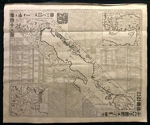
Carte de geographie des differents etats de la Republique de Venise, l'abreg� de son gouvernement politiqueb et ecclesiastique,et les etats o� elle a port� la gloire de ses armes.
Publication Date: 1708
Seller: BOTTEGHINA D'ARTE GALLERIA K�PROS, Rosignano Solvay, LI, Italy
Seller rating 2 out of 5 stars

Art / Print / Poster
No legatura. Condition: Ottimo. Tratta dall' "Atlas Historique", Amsterdam, 1708 circa. Incisione in rame, cm 50,5 x 62 circa (alla lastra) pi� margini. L'Italia � tagliata verticalmente con la parte centrale dello stivale e tutto il versante est, il Golfo di Venezia, l'Istria, la Dalmazia, l'Albania e la Morea; arricchiscono la carta due riquadri ("Carte des environs del la Ville de Venise" e "Carte des etats o� la Republique a port� ses Armes") e un copiosissimo elenco dei combattimenti e delle vittorie della Repubblica di Venezia. Henri Chatelain (Parigi, 1684 1743), pastore ugonotto parigino che visse anche a Londra, L'Aia e Amsterdam, � noto per il suo "Atlas Historique", corposa opera in sette volumi che pubblic� ad Amsterdam intorno al 1708 assieme ai suoi fratelli. .
-
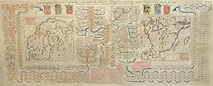
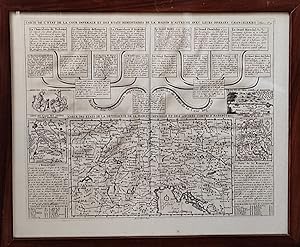
Carte Genealogique pour Conduire a L'Historique des Rois du Nord, La Carte de Leurs etats, Leurs Armes et Des Remarques Pour Conduire a L'Intellgience de L'Histoire du Nord
Publication Date: 1718
Seller: William Chrisant & Sons, ABAA, ILAB. IOBA, ABA, Ephemera Society, Fort Lauderdale, FL, U.S.A.
Association Member: ABAA ESA ILAB
Seller rating 5 out of 5 stars
First Edition
Pr. Condition: Very Good. First Edition. Very Good. 1718. First Edition. Pr. Large engraving featuring royal lineage of Scandinavia, as well as two finely illustrated maps: "Nouvelle Carte du Royaume de Suede" & "Carte du Royaume de Gothie". Period hand-coloring. 17 in x 40.5 in. ; 17''x 40.5''; All shipments through USPS insured Priority Mail. .