
Order Total (1 Item Items):
Shipping Destination:

Hunter Frederic Fraser (1 results)
Skip to main search results
Search filters
Product Type
- All Product Types
- Books (1)
- Magazines & Periodicals (No further results match this refinement)
- Comics (No further results match this refinement)
- Sheet Music (No further results match this refinement)
- Art, Prints & Posters (No further results match this refinement)
- Photographs (No further results match this refinement)
- Maps (No further results match this refinement)
- Manuscripts & Paper Collectibles (No further results match this refinement)
Condition Learn more
- New (No further results match this refinement)
- As New, Fine or Near Fine (No further results match this refinement)
- Very Good or Good (No further results match this refinement)
- Fair or Poor (No further results match this refinement)
- As Described (1)
Binding
- All Bindings
- Hardcover (No further results match this refinement)
- Softcover (1)
Collectible Attributes
- First Edition (No further results match this refinement)
- Signed (No further results match this refinement)
- Dust Jacket (No further results match this refinement)
- Seller-Supplied Images (1)
- Not Print on Demand (1)
Language (1)
Price
- Any Price
- Under US$ 25 (No further results match this refinement)
- US$ 25 to US$ 50 (No further results match this refinement)
- Over US$ 50
Free Shipping
- Free Shipping to U.S.A. (No further results match this refinement)
Seller Location
Seller Rating
-
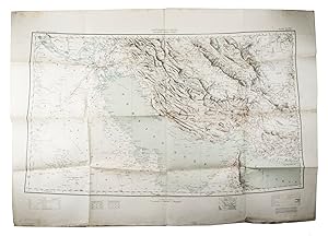
Southern Asia series - Southern Persia sheet - Persia, Arabia and Turkey in Asia
Published by Survey of India Office], sold at the Map Record and Issue Office, Calcutta,, [Dehradun,, 1912
Seller: Antiquariaat FORUM BV, Houten, Netherlands
Seller rating 5 out of 5 stars

US$ 17,958.55
US$ 29.06 shipping
Ships from Netherlands to U.S.A.Quantity: 1 available
Add to basketLarge detailed terrain map of the Persian Gulf and the surrounding area with a legend of geographic denominations in English, Arabic and Persian, such as "Fort: Qasr (Arabic), Kaleh, Kalat (Persian)". The map shows terrain levels in particular detail and the major roads, railways and telegraph lines. The sheet latitude limits are: "24� - 32� north and 44� - 60� south", including Qatar, Kuwait, the Emirates, Saudi Arabia, Iran, Iraq and more.The map was published in 1912 by the India Survey Office under the direction of Sir Sidney Gerald Burrard (1860-1953), who was Colonel and Surveyor General of India in that year. He was closely involved in the geographical and cartographic survey of India, especially the Himalayas, and retired one year after publication of the present map.As the Southern Persia sheet, the present map is part of a very large 9-sheet combined map covering the area from the Red Sea to India, called the Survey of India Southern Asia Series (1912-1945). The present map and a separately published index could be obtained only on application through an officer at the Map Record and Issue Office in Calcutta.Some slight foxing. A tiny tear on the crossing of two folds, bottom edge frayed. Otherwise in good condition.l Daniel Foliard, "Conflicted cartographies of a peninsula", in: Geographies of contact, 2019, pp. 71-76; F. Fraser Hunter, "Reminiscences of the map of Arabia and the Persian Gulf", in: The geographical journal, 54 (1919), pp. 355-363. Folded. Large photozincographed (heliozincographed) folding map on a scale of 1:2,000,000 in black, blue and red, with relief shown by contours, hachures and gradient tints.