Order Total (1 Item Items):
Shipping Destination:

Inosuke Ide (1 results)
Skip to main search results
Search filters
Product Type
- All Product Types
- Books (1)
- Magazines & Periodicals (No further results match this refinement)
- Comics (No further results match this refinement)
- Sheet Music (No further results match this refinement)
- Art, Prints & Posters (No further results match this refinement)
- Photographs (No further results match this refinement)
- Maps (No further results match this refinement)
- Manuscripts & Paper Collectibles (No further results match this refinement)
Condition Learn more
- New (No further results match this refinement)
- As New, Fine or Near Fine (1)
- Very Good or Good (No further results match this refinement)
- Fair or Poor (No further results match this refinement)
- As Described (No further results match this refinement)
Binding
- All Bindings
- Hardcover (No further results match this refinement)
- Softcover (1)
Collectible Attributes
- First Edition (1)
- Signed (No further results match this refinement)
- Dust Jacket (No further results match this refinement)
- Seller-Supplied Images (1)
- Not Print on Demand (1)
Language (1)
Price
- Any Price
- Under US$ 25 (No further results match this refinement)
- US$ 25 to US$ 50 (No further results match this refinement)
- Over US$ 50
Free Shipping
- Free Shipping to U.S.A. (No further results match this refinement)
Seller Location
Seller Rating
-
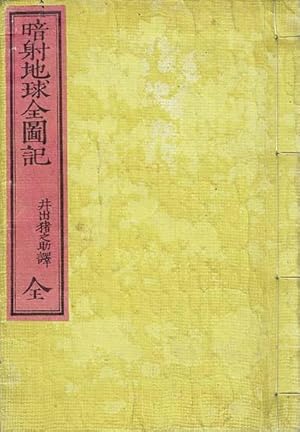
Ansha Chikyu Zenzuki: Tsuketari Yakuzu
Published by Bunkeido, Kajita Kizo, 1874
Seller: Kagerou Bunko (ABAJ, ILAB), Tokyo, Japan
Association Member: ILAB
Seller rating 2 out of 5 stars

First Edition
Soft cover. Condition: Near Fine. 1st Edition. A Meiji period textbook used to teach both students and teachers the readings of the country, state, mountain, and river names that appeared on the world maps distributed to schools by the Japanese Government. The readings of the place names in this book (written in katakana) were mainly decided by Japanese government advisor Marion Scott (1843-1922), however there are also many place names recorded in Dutch which, due to existing popularly in Japan, remain unchanged into their English equivalents. Includes a folding colour woodblock-printed world map as well as a section on Australia, with the readings of Adelaide, Sydney, the Gulf of Carpentaria, the River Torrens, Lake Gregory, Tasmania, and so on, recorded in katakana. Original Japanese wrappers, lightly stained. Occasional small marks to text, light crease to page corners. Small ex-ownership stamp to last page of text. Includes a folding colour woodblock-printed world map with a few small wormholes to margins. Otherwise near fine. 1 v., complete. 18.3x11.7cm. 2, [1 folding map (12x29.8cm)], 58 leaves. Text in Japanese. Used book.