Order Total (1 Item Items):
Shipping Destination:

Janssonius Workshop (20 results)
Skip to main search results
Search filters
Product Type
- All Product Types
- Books (19)
- Magazines & Periodicals (No further results match this refinement)
- Comics (No further results match this refinement)
- Sheet Music (No further results match this refinement)
- Art, Prints & Posters (1)
- Photographs (No further results match this refinement)
- Maps (No further results match this refinement)
- Manuscripts & Paper Collectibles (No further results match this refinement)
Condition Learn more
- New (No further results match this refinement)
- As New, Fine or Near Fine (No further results match this refinement)
- Very Good or Good (20)
- Fair or Poor (No further results match this refinement)
- As Described (No further results match this refinement)
Binding
- All Bindings
- Hardcover (No further results match this refinement)
- Softcover (No further results match this refinement)
Collectible Attributes
- First Edition (No further results match this refinement)
- Signed (No further results match this refinement)
- Dust Jacket (No further results match this refinement)
- Seller-Supplied Images (20)
- Not Print on Demand (20)
Language (1)
Price
- Any Price
- Under US$ 25 (No further results match this refinement)
- US$ 25 to US$ 50 (No further results match this refinement)
- Over US$ 50
Free Shipping
- Free Shipping to U.S.A. (No further results match this refinement)
Seller Location
Seller Rating
-
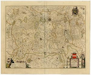
Antique Print-HAINAUT-HENEGOUWEN-NAMEN-Janssonius-1647
Publication Date: 1647
Seller: Pictura Prints, Art & Books, Overasselt, Netherlands
Seller rating 5 out of 5 stars

Condition: Good. unknown carthographer (illustrator). 'Comitatuum Hannoniae et Namurci descriptio.'Contemporary (original / old) hand coloured etching / engraving on hand laid paper. Watermark: We found no watermark. Paper appears from the Veluwe region in the Netherlands. Sheet size: 58,6 x 48,5 cm. (23,1 x 19,1 inch). Image size: 50,3 x 38,8 cm. (19,8 x 15,3 inch).From: "Atlas Novus sive Theatrum Orbis Terrarum", Amsterdam: Johannes Janssonius, 1647. This Atlas was published 1638-66. This item is from the 1647 latin ed. (Janssonius 1647 / 02-2020)Made by 'Janssonius workshop' after 'unknown carthographer'. Publisher: Johannes Janssonius also known as Jan Jansson (1588-1664) was born in Arnhem, Netherlands. His father was a bookseller and publisher (Jan Janszoon the Elder). When he married the daughter of the cartographer Jodocus Hondius he also set up a business as book publisher in Amsterdam. His first map was published in 1616. Around 15 years later he set up a partnership with his brother in law Hondius add issued further editions of the Mercator/Hondius atlas. After his death his heirs still have published several maps. Many of his plates have been acquired by Pieter Schenk and Gerard Valk.Condition: Good, given age. Paper separation at the lower and top middle fold, backed. Original middle fold as issued. Tear at right bottom extending 1 inch into image, backed. Light brown offsetting from colours on oposing pages, as is common. General age-related toning and/or occasional minor defects from handling. Please study scan carefully.Keywords: HAINAUT-HENEGOUWEN-NAMENTPC-Expo-P8-18.
-
Antique Print-CAMBRAY-BOUCHAIN-VALENCIENNES-Janssonius-1647
Publication Date: 1647
Seller: Pictura Prints, Art & Books, Overasselt, Netherlands
Seller rating 5 out of 5 stars
Condition: Good. unknown carthographer (illustrator). 'Arcihiepiscopatus Cameracansis Archevesche de Cambray.'Contemporary (original / old) hand coloured etching / engraving on hand laid paper. Watermark: We found no watermark. Paper appears from the Veluwe region in the Netherlands. Sheet size: 58,5 x 48,5 cm. (23 x 19,1 inch). Image size: 49,7 x 38,8 cm. (19,6 x 15,3 inch).From: "Atlas Novus sive Theatrum Orbis Terrarum", Amsterdam: Johannes Janssonius, 1647. This Atlas was published 1638-66. This item is from the 1647 latin ed. (Janssonius 1647 / 02-2020)Made by 'Janssonius workshop' after 'unknown carthographer'. Publisher: Johannes Janssonius also known as Jan Jansson (1588-1664) was born in Arnhem, Netherlands. His father was a bookseller and publisher (Jan Janszoon the Elder). When he married the daughter of the cartographer Jodocus Hondius he also set up a business as book publisher in Amsterdam. His first map was published in 1616. Around 15 years later he set up a partnership with his brother in law Hondius add issued further editions of the Mercator/Hondius atlas. After his death his heirs still have published several maps. Many of his plates have been acquired by Pieter Schenk and Gerard Valk.Condition: Good, given age. Minimal paper separation at the lower middle fold margin, backed. Original middle fold as issued. Light brown offsetting from colours on oposing pages, as is common. General age-related toning and/or occasional minor defects from handling. Please study scan carefully.Keywords: CAMBRAY-BOUCHAIN-VALENCIENNESTPC-Expo-P8-19.
-
Antique Print-FRANCE- ARTOIS-ARTESIA-Janssonius-1647
Publication Date: 1647
Seller: Pictura Prints, Art & Books, Overasselt, Netherlands
Seller rating 5 out of 5 stars
Condition: Good. unknown carthographer (illustrator). 'Artesia Comitatus Artois.'Contemporary (original / old) hand coloured etching / engraving on hand laid paper. Watermark: We found no watermark. Paper appears from the Veluwe region in the Netherlands. Sheet size: 58,8 x 48,5 cm. (23,1 x 19,1 inch). Image size: 50,3 x 38,4 cm. (19,8 x 15,1 inch).From: "Atlas Novus sive Theatrum Orbis Terrarum", Amsterdam: Johannes Janssonius, 1647. This Atlas was published 1638-66. This item is from the 1647 latin ed. (Janssonius 1647 / 02-2020)Made by 'Janssonius workshop' after 'unknown carthographer'. Publisher: Johannes Janssonius also known as Jan Jansson (1588-1664) was born in Arnhem, Netherlands. His father was a bookseller and publisher (Jan Janszoon the Elder). When he married the daughter of the cartographer Jodocus Hondius he also set up a business as book publisher in Amsterdam. His first map was published in 1616. Around 15 years later he set up a partnership with his brother in law Hondius add issued further editions of the Mercator/Hondius atlas. After his death his heirs still have published several maps. Many of his plates have been acquired by Pieter Schenk and Gerard Valk.Condition: Good, given age. Original middle fold as issued. Light brown offsetting from colours on oposing pages, as is common. General age-related toning and/or occasional minor defects from handling. Please study scan carefully.Keywords: FRANCE- ARTOIS-ARTESIATPC-Expo-P8-20.
-
Antique Print-LEODIENSIS-LUIK-LIEGE-MAASTRICHT-LIMBURG-Janssonius-1647
Publication Date: 1647
Seller: Pictura Prints, Art & Books, Overasselt, Netherlands
Seller rating 5 out of 5 stars
Condition: Good. unknown carthographer (illustrator). "'Dioecesis Leodiensis Accurata Tabula 'Contemporary (original / old) hand coloured etching / engraving on hand laid paper. Watermark: We found no watermark. Paper appears from the Veluwe region in the Netherlands. Sheet size: 59 x 48,5 cm. (23,2 x 19,1 inch). Image size: 54,5 x 45,9 cm. (21,5 x 18,1 inch).From: "Atlas Novus sive Theatrum Orbis Terrarum", Amsterdam: Johannes Janssonius, 1647. This Atlas was published 1638-66. This item is from the 1647 latin ed. (Janssonius 1647 / 02-2020)Made by 'Janssonius workshop' after 'unknown carthographer'. Publisher: Johannes Janssonius also known as Jan Jansson (1588-1664) was born in Arnhem, Netherlands. His father was a bookseller and publisher (Jan Janszoon the Elder). When he married the daughter of the cartographer Jodocus Hondius he also set up a business as book publisher in Amsterdam. His first map was published in 1616. Around 15 years later he set up a partnership with his brother in law Hondius add issued further editions of the Mercator/Hondius atlas. After his death his heirs still have published several maps. Many of his plates have been acquired by Pieter Schenk and Gerard Valk.Condition: Good, given age. Paper separation at the lower middle fold margin, backed. Original middle fold as issued. Light brown offsetting from colours on oposing pages, as is common. General age-related toning and/or occasional minor defects from handling. Please study scan carefully.Keywords: LEODIENSIS-LUIK-LIEGE-MAASTRICHT-LIMBURGTPC-Expo-P8-03".
-
Antique Print-FRANCE-ARLEUX-DOUAY-TOURNAY-LILLE-Janssonius-1647
Publication Date: 1647
Seller: Pictura Prints, Art & Books, Overasselt, Netherlands
Seller rating 5 out of 5 stars
Condition: Good. unknown carthographer (illustrator). "'Flandria Gallica 'Contemporary (original / old) hand coloured etching / engraving on hand laid paper. Watermark: We found no watermark. Paper appears from the Veluwe region in the Netherlands. Sheet size: 58,6 x 48,5 cm. (23,1 x 19,1 inch). Image size: 50,5 x 40,1 cm. (19,9 x 15,8 inch).From: "Atlas Novus sive Theatrum Orbis Terrarum", Amsterdam: Johannes Janssonius, 1647. This Atlas was published 1638-66. This item is from the 1647 latin ed. (Janssonius 1647 / 02-2020)Made by 'Janssonius workshop' after 'unknown carthographer'. Publisher: Johannes Janssonius also known as Jan Jansson (1588-1664) was born in Arnhem, Netherlands. His father was a bookseller and publisher (Jan Janszoon the Elder). When he married the daughter of the cartographer Jodocus Hondius he also set up a business as book publisher in Amsterdam. His first map was published in 1616. Around 15 years later he set up a partnership with his brother in law Hondius add issued further editions of the Mercator/Hondius atlas. After his death his heirs still have published several maps. Many of his plates have been acquired by Pieter Schenk and Gerard Valk.Condition: Good, given age. Paper separation and tear at the lower middle fold margin, backed. Creasing of middle fold area. Original middle fold as issued. Light brown offsetting from colours on oposing pages, as is common. General age-related toning and/or occasional minor defects from handling. Please study scan carefully.Keywords: FRANCE-ARLEUX-DOUAY-TOURNAY-LILLETPC-Expo-P8-22".
-
Antique Print-CALAIS-NIEUWPOORT-BELGIUM-SAINT OMER-Janssonius-1647
Publication Date: 1647
Seller: Pictura Prints, Art & Books, Overasselt, Netherlands
Seller rating 5 out of 5 stars
Condition: Good. unknown carthographer (illustrator). "'Flandriae pars occidentalis 'Contemporary (original / old) hand coloured etching / engraving on hand laid paper. Watermark: We found no watermark. Paper appears from the Veluwe region in the Netherlands. Sheet size: 58,5 x 48,5 cm. (23 x 19,1 inch). Image size: 50,2 x 40 cm. (19,8 x 15,7 inch).From: "Atlas Novus sive Theatrum Orbis Terrarum", Amsterdam: Johannes Janssonius, 1647. This Atlas was published 1638-66. This item is from the 1647 latin ed. (Janssonius 1647 / 02-2020)Made by 'Janssonius workshop' after 'unknown carthographer'. Publisher: Johannes Janssonius also known as Jan Jansson (1588-1664) was born in Arnhem, Netherlands. His father was a bookseller and publisher (Jan Janszoon the Elder). When he married the daughter of the cartographer Jodocus Hondius he also set up a business as book publisher in Amsterdam. His first map was published in 1616. Around 15 years later he set up a partnership with his brother in law Hondius add issued further editions of the Mercator/Hondius atlas. After his death his heirs still have published several maps. Many of his plates have been acquired by Pieter Schenk and Gerard Valk.Condition: Good, given age. Minimal paper separation at the lower middle fold margin, backed. Original middle fold as issued. Light brown offsetting from colours on oposing pages, as is common. General age-related toning and/or occasional minor defects from handling. Please study scan carefully.Keywords: CALAIS-NIEUWPOORT-BELGIUM-SAINT OMERTPC-Expo-P8-24".
-
Antique Print-NETHERLANDS-COURSE OF RIJN-MAAS-WAAL-Janssonius-1647
Publication Date: 1647
Seller: Pictura Prints, Art & Books, Overasselt, Netherlands
Seller rating 5 out of 5 stars
Condition: Good. unknown carthographer (illustrator). "'Descriptio Fluminum Rheni, Vahalis et Mosae imperium Noviomagense, Bataviam 'Contemporary (original / old) hand coloured etching / engraving on hand laid paper. Watermark: We found no watermark. Paper appears from the Veluwe region in the Netherlands. Sheet size: 58,2 x 48,5 cm. (22,9 x 19,1 inch). Image size: 49,7 x 37,7 cm. (19,6 x 14,8 inch).From: "Atlas Novus sive Theatrum Orbis Terrarum", Amsterdam: Johannes Janssonius, 1647. This Atlas was published 1638-66. This item is from the 1647 latin ed. (Janssonius 1647 / 02-2020)Made by 'Janssonius workshop' after 'unknown carthographer'. Publisher: Johannes Janssonius also known as Jan Jansson (1588-1664) was born in Arnhem, Netherlands. His father was a bookseller and publisher (Jan Janszoon the Elder). When he married the daughter of the cartographer Jodocus Hondius he also set up a business as book publisher in Amsterdam. His first map was published in 1616. Around 15 years later he set up a partnership with his brother in law Hondius add issued further editions of the Mercator/Hondius atlas. After his death his heirs still have published several maps. Many of his plates have been acquired by Pieter Schenk and Gerard Valk.Condition: Good, given age. Paper separation at the lower middle fold margin, backed. Original middle fold as issued. Light brown offsetting from colours on oposing pages, as is common. Damp staining in lower margin. Colour stain in left margin. General age-related toning and/or occasional minor defects from handling. Please study scan carefully.Keywords: NETHERLANDS-COURSE OF RIJN-MAAS-WAALTPC-Expo-P8-27".
-
Antique Print-BELGIUM-LEUVEN-LOUVAIN-TIENEN-AERSCHOT-Janssonius-1647
Publication Date: 1647
Seller: Pictura Prints, Art & Books, Overasselt, Netherlands
Seller rating 5 out of 5 stars
No binding. Condition: Good. unknown carthographer (illustrator). "'Prima pars Brabantiae . .Lovanium. Auctore Michaele Florentio a Langren 'Contemporary (original / old) hand coloured etching / engraving on hand laid paper. Watermark: We found no watermark. Paper appears from the Veluwe region in the Netherlands. Sheet size: 58,9 x 48,5 cm. (23,2 x 19,1 inch). Image size: 53,6 x 42,2 cm. (21,1 x 16,6 inch).From: "Atlas Novus sive Theatrum Orbis Terrarum", Amsterdam: Johannes Janssonius, 1647. This Atlas was published 1638-66. This item is from the 1647 latin ed. (Janssonius 1647 / 02-2020)Made by 'Janssonius workshop' after 'unknown carthographer'. Publisher: Johannes Janssonius also known as Jan Jansson (1588-1664) was born in Arnhem, Netherlands. His father was a bookseller and publisher (Jan Janszoon the Elder). When he married the daughter of the cartographer Jodocus Hondius he also set up a business as book publisher in Amsterdam. His first map was published in 1616. Around 15 years later he set up a partnership with his brother in law Hondius add issued further editions of the Mercator/Hondius atlas. After his death his heirs still have published several maps. Many of his plates have been acquired by Pieter Schenk and Gerard Valk. Cartographer: Michiel Florent van Langren (Amsterdam 15981675, Brussels) was a cartographer from the Southern Netherlands. He is known for being the first to make a map of the moon, as well as initiating the trend of selenography.Condition: Good, given age. Creasing along the middle fold. Paper separation at the lower middle fold margin, backed. Original middle fold as issued. Light brown offsetting from colours on oposing page, as is common. General age-related toning and/or occasional minor defects from handling. Please study scan carefully.Keywords: BELGIUM-LEUVEN-LOUVAIN-TIENEN-AERSCHOTTPC-Expo-P8-41".
-
Antique Print-NAMURCUM-NAMEN-DINANT-Janssonius-1647
Publication Date: 1647
Seller: Pictura Prints, Art & Books, Overasselt, Netherlands
Seller rating 5 out of 5 stars
Condition: Good. unknown carthographer (illustrator). 'Namurcum Comitatus Auctore Iohann Surhonio.'Contemporary (original / old) hand coloured etching / engraving on hand laid paper. Watermark: We found no watermark. Paper appears from the Veluwe region in the Netherlands. Sheet size: 57,8 x 48,5 cm. (22,8 x 19,1 inch). Image size: 53 x 41,7 cm. (20,9 x 16,4 inch).From: "Atlas Novus sive Theatrum Orbis Terrarum", Amsterdam: Johannes Janssonius, 1647. This Atlas was published 1638-66. This item is from the 1647 latin ed. (Janssonius 1647 / 02-2020)Made by 'Janssonius workshop' after 'unknown carthographer'. Publisher: Johannes Janssonius also known as Jan Jansson (1588-1664) was born in Arnhem, Netherlands. His father was a bookseller and publisher (Jan Janszoon the Elder). When he married the daughter of the cartographer Jodocus Hondius he also set up a business as book publisher in Amsterdam. His first map was published in 1616. Around 15 years later he set up a partnership with his brother in law Hondius add issued further editions of the Mercator/Hondius atlas. After his death his heirs still have published several maps. Many of his plates have been acquired by Pieter Schenk and Gerard Valk. Cartographer: the 16th century cartographer, goldsmith and engraver Jean Surhon.Condition: Good, given age. Paper separation at the lower middle fold, backed. Original middle fold as issued. Light brown offsetting from colours on oposing pages, as is common. General age-related toning and/or occasional minor defects from handling. Please study scan carefully.Keywords: NAMURCUM-NAMEN-DINANTTPC-Expo-P8-17.
-
Antique Print-FOSSA EUGENIA-CANAL-VENLO-RIJN-MAAS-Janssonius-1647
Publication Date: 1647
Seller: Pictura Prints, Art & Books, Overasselt, Netherlands
Seller rating 5 out of 5 stars
Condition: Good. unknown carthographer (illustrator). "'Fossa Eugeniana quae a rheno ad mosam duci coepta est 'Contemporary (original / old) hand coloured etching / engraving on hand laid paper. Watermark: We found no watermark. Paper appears from the Veluwe region in the Netherlands. Sheet size: 58,2 x 48,5 cm. (22,9 x 19,1 inch). Image size: 49,5 x 37,3 cm. (19,5 x 14,7 inch).From: "Atlas Novus sive Theatrum Orbis Terrarum", Amsterdam: Johannes Janssonius, 1647. This Atlas was published 1638-66. This item is from the 1647 latin ed. (Janssonius 1647 / 02-2020)Made by 'Janssonius workshop' after 'unknown carthographer'. Publisher: Johannes Janssonius also known as Jan Jansson (1588-1664) was born in Arnhem, Netherlands. His father was a bookseller and publisher (Jan Janszoon the Elder). When he married the daughter of the cartographer Jodocus Hondius he also set up a business as book publisher in Amsterdam. His first map was published in 1616. Around 15 years later he set up a partnership with his brother in law Hondius add issued further editions of the Mercator/Hondius atlas. After his death his heirs still have published several maps. Many of his plates have been acquired by Pieter Schenk and Gerard Valk.Condition: Good, given age. Minimal paper separation at the lower middle fold margin, backed. Original middle fold as issued. Light brown offsetting from colours on oposing pages, as is common. General age-related toning and/or occasional minor defects from handling. Please study scan carefully.Keywords: FOSSA EUGENIA-CANAL-VENLO-RIJN-MAASTPC-Expo-P8-26".
-
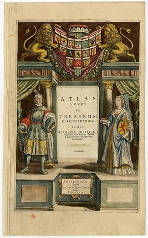
Antique Print-TITLE PAGE-ATLAS NOVUS-THEATRUM ORBIS TERRARUM-Janssonius-1647
Publication Date: 1647
Seller: Pictura Prints, Art & Books, Overasselt, Netherlands
Seller rating 5 out of 5 stars
Art / Print / Poster
No binding. Condition: Good. unknown carthographer (illustrator). 'Atlas Novus sive Theatrum Orbis Terrarum ., Amstelodami, Apud Ioannem Ianssonium Anno 1647.'Contemporary (original / old) hand coloured etching / engraving on hand laid paper. Watermark: We found no watermark. Paper appears from the Veluwe region in the Netherlands. Sheet size: 29,8 x 48,5 cm. (11,7 x 19,1 inch). Image size: 26 x 40,1 cm. (10,2 x 15,8 inch).From: "Atlas Novus sive Theatrum Orbis Terrarum", Amsterdam: Johannes Janssonius, 1647. This Atlas was published 1638-66. This item is from the 1647 latin ed. (Janssonius 1647 / 02-2020)Made by 'Janssonius workshop' after 'unknown carthographer'. Publisher: Johannes Janssonius also known as Jan Jansson (1588-1664) was born in Arnhem, Netherlands. His father was a bookseller and publisher (Jan Janszoon the Elder). When he married the daughter of the cartographer Jodocus Hondius he also set up a business as book publisher in Amsterdam. His first map was published in 1616. Around 15 years later he set up a partnership with his brother in law Hondius add issued further editions of the Mercator/Hondius atlas. After his death his heirs still have published several maps. Many of his plates have been acquired by Pieter Schenk and Gerard Valk.Condition: Good, given age. Some paper damage from acidification in the left middle side of the image, backed with contemporary paper. Creasing in the left margin. A colour stain in the lower margin, just below the image. Light soiling. General age-related toning and/or occasional minor defects from handling. Please study scan carefully.Keywords: TITLE PAGE-ATLAS NOVUS-THEATRUM ORBIS TERRARUMTPC-Expo-P8-42.
-
Antique Print-BELGIUM-FLANDERS-GENT-WAAS-Janssonius-1647
Publication Date: 1647
Seller: Pictura Prints, Art & Books, Overasselt, Netherlands
Seller rating 5 out of 5 stars
Condition: Good. unknown carthographer (illustrator). "'Flandriae partes duae quarum altera Propietaria altera Imperialis 'Contemporary (original / old) hand coloured etching / engraving on hand laid paper. Watermark: We found no watermark. Paper appears from the Veluwe region in the Netherlands. Sheet size: 59,1 x 48,5 cm. (23,3 x 19,1 inch). Image size: 52,3 x 41,3 cm. (20,6 x 16,3 inch).From: "Atlas Novus sive Theatrum Orbis Terrarum", Amsterdam: Johannes Janssonius, 1647. This Atlas was published 1638-66. This item is from the 1647 latin ed. (Janssonius 1647 / 02-2020)Made by 'Janssonius workshop' after 'unknown carthographer'. Publisher: Johannes Janssonius also known as Jan Jansson (1588-1664) was born in Arnhem, Netherlands. His father was a bookseller and publisher (Jan Janszoon the Elder). When he married the daughter of the cartographer Jodocus Hondius he also set up a business as book publisher in Amsterdam. His first map was published in 1616. Around 15 years later he set up a partnership with his brother in law Hondius add issued further editions of the Mercator/Hondius atlas. After his death his heirs still have published several maps. Many of his plates have been acquired by Pieter Schenk and Gerard Valk.Condition: Good, given age. Paper separation at the lower middle fold margin, backed. Original middle fold as issued. Light brown offsetting from colours on oposing pages, as is common. General age-related toning and/or occasional minor defects from handling. Please study scan carefully.Keywords: BELGIUM-FLANDERS-GENT-WAASTPC-Expo-P8-21".
-
Antique Print-BELGIUM-NIEUWPOORT-MIDDELBURG-GHENT-Janssonius-1647
Publication Date: 1647
Seller: Pictura Prints, Art & Books, Overasselt, Netherlands
Seller rating 5 out of 5 stars
Condition: Good. unknown carthographer (illustrator). 'Flandriae Teutonicae pars Orientalior.'Contemporary (original / old) hand coloured etching / engraving on hand laid paper. Watermark: We found no watermark. Paper appears from the Veluwe region in the Netherlands. Sheet size: 58,5 x 48,5 cm. (23 x 19,1 inch). Image size: 50,5 x 40 cm. (19,9 x 15,7 inch).From: "Atlas Novus sive Theatrum Orbis Terrarum", Amsterdam: Johannes Janssonius, 1647. This Atlas was published 1638-66. This item is from the 1647 latin ed. (Janssonius 1647 / 02-2020)Made by 'Janssonius workshop' after 'unknown carthographer'. Publisher: Johannes Janssonius also known as Jan Jansson (1588-1664) was born in Arnhem, Netherlands. His father was a bookseller and publisher (Jan Janszoon the Elder). When he married the daughter of the cartographer Jodocus Hondius he also set up a business as book publisher in Amsterdam. His first map was published in 1616. Around 15 years later he set up a partnership with his brother in law Hondius add issued further editions of the Mercator/Hondius atlas. After his death his heirs still have published several maps. Many of his plates have been acquired by Pieter Schenk and Gerard Valk.Condition: Good, given age. Paper separation at the lower middle fold margin, backed. Original middle fold as issued. Light brown offsetting from colours on oposing pages, as is common. Light damp staining in lower margin. General age-related toning and/or occasional minor defects from handling. Please study scan carefully.Keywords: BELGIUM-NIEUWPOORT-MIDDELBURG-GHENTTPC-Expo-P8-23.
-
Antique Print-BELGIUM-ATWERPEN-NETHERLANDS-BREDA-BERGEN OP ZOOM-Janssonius-1647
Publication Date: 1647
Seller: Pictura Prints, Art & Books, Overasselt, Netherlands
Seller rating 5 out of 5 stars
No binding. Condition: Good. unknown carthographer (illustrator). "'Tertia pars Brabantia e Antverpia 'Contemporary (original / old) hand coloured etching / engraving on hand laid paper. Watermark: We found no watermark. Paper appears from the Veluwe region in the Netherlands. Sheet size: 58,6 x 48,5 cm. (23,1 x 19,1 inch). Image size: 51,9 x 41,8 cm. (20,4 x 16,5 inch).From: "Atlas Novus sive Theatrum Orbis Terrarum", Amsterdam: Johannes Janssonius, 1647. This Atlas was published 1638-66. This item is from the 1647 latin ed. (Janssonius 1647 / 02-2020)Made by 'Janssonius workshop' after 'unknown carthographer'. Publisher: Johannes Janssonius also known as Jan Jansson (1588-1664) was born in Arnhem, Netherlands. His father was a bookseller and publisher (Jan Janszoon the Elder). When he married the daughter of the cartographer Jodocus Hondius he also set up a business as book publisher in Amsterdam. His first map was published in 1616. Around 15 years later he set up a partnership with his brother in law Hondius add issued further editions of the Mercator/Hondius atlas. After his death his heirs still have published several maps. Many of his plates have been acquired by Pieter Schenk and Gerard Valk. Cartographer: Michiel Florent van Langren (Amsterdam 15981675, Brussels) was a cartographer from the Southern Netherlands. He is known for being the first to make a map of the moon, as well as initiating the trend of selenography.Condition: Good, given age. Paper separation at the lower middle fold, backed. Original middle fold as issued. Light brown offsetting from colours on oposing page, as is common. General age-related toning and/or occasional minor defects from handling. Please study scan carefully.Keywords: BELGIUM-ATWERPEN-NETHERLANDS-BREDA-BERGEN OP ZOOMTPC-Expo-P8-39".
-
Antique Print-BETUWE-BOMMELERWAARD-TIELERWAARD-Janssonius-1647
Publication Date: 1647
Seller: Pictura Prints, Art & Books, Overasselt, Netherlands
Seller rating 5 out of 5 stars
No binding. Condition: Good. unknown carthographer (illustrator). 'Ducatus Gelriae pars prima quae est Neomagensis.'Contemporary (original / old) hand coloured etching / engraving on hand laid paper. Watermark: We found no watermark. Paper appears from the Veluwe region in the Netherlands. Sheet size: 58,5 x 48,5 cm. (23 x 19,1 inch). Image size: 52,2 x 38,7 cm. (20,6 x 15,2 inch).From: "Atlas Novus sive Theatrum Orbis Terrarum", Amsterdam: Johannes Janssonius, 1647. This Atlas was published 1638-66. This item is from the 1647 latin ed. (Janssonius 1647 / 02-2020)Made by 'Janssonius workshop' after 'unknown carthographer'. Publisher: Johannes Janssonius also known as Jan Jansson (1588-1664) was born in Arnhem, Netherlands. His father was a bookseller and publisher (Jan Janszoon the Elder). When he married the daughter of the cartographer Jodocus Hondius he also set up a business as book publisher in Amsterdam. His first map was published in 1616. Around 15 years later he set up a partnership with his brother in law Hondius add issued further editions of the Mercator/Hondius atlas. After his death his heirs still have published several maps. Many of his plates have been acquired by Pieter Schenk and Gerard Valk.Condition: Good, given age. Paper separation at the lower middle fold margin, backed. Original middle fold as issued. Light brown offsetting from colours on oposing pages, as is common. General age-related toning and/or occasional minor defects from handling. Please study scan carefully.Keywords: BETUWE-BOMMELERWAARD-TIELERWAARDTPC-Expo-P8-32.
-
Antique Print-GOEREE-BEIJERLAND-DELFT-ROTTERDAM-THE HAGUE-Janssonius-1647
Publication Date: 1647
Seller: Pictura Prints, Art & Books, Overasselt, Netherlands
Seller rating 5 out of 5 stars
Condition: Good. unknown carthographer (illustrator). "'Novissima Delflandiae, Schielandiae . Voornae, Overflackeae, Goereae Aucteur Balthazaro Flor.a Berckenrode, Amselodami Sumptibus Ioannis Ianssoni anno 1641.'Contemporary (original / old) hand coloured etching / engraving on hand laid paper. Watermark: We found no watermark. Paper appears from the Veluwe region in the Netherlands. Sheet size: 58,7 x 48,5 cm. (23,1 x 19,1 inch). Image size: 55,3 x 45,2 cm. (21,8 x 17,8 inch).From: "Atlas Novus sive Theatrum Orbis Terrarum", Amsterdam: Johannes Janssonius, 1647. This Atlas was published 1638-66. This item is from the 1647 latin ed. (Janssonius 1647 / 02-2020)Made by 'Janssonius workshop' after 'unknown carthographer'. Publisher: Johannes Janssonius also known as Jan Jansson (1588-1664) was born in Arnhem, Netherlands. His father was a bookseller and publisher (Jan Janszoon the Elder). When he married the daughter of the cartographer Jodocus Hondius he also set up a business as book publisher in Amsterdam. His first map was published in 1616. Around 15 years later he set up a partnership with his brother in law Hondius add issued further editions of the Mercator/Hondius atlas. After his death his heirs still have published several maps. Many of his plates have been acquired by Pieter Schenk and Gerard Valk.Condition: Good, given age. Original middle fold as issued. Light brown offsetting from colours on oposing pages, as is common. General age-related toning and/or occasional minor defects from handling. Please study scan carefully.Keywords: GOEREE-BEIJERLAND-DELFT-ROTTERDAM-THE HAGUETPC-Expo-P8-15".
-
Antique Print-NETHERLANDS-BELGIUM-LUXEMBOURG-Janssonius-1647
Publication Date: 1647
Seller: Pictura Prints, Art & Books, Overasselt, Netherlands
Seller rating 5 out of 5 stars
Condition: Good. unknown carthographer (illustrator). "'Nova Totius Belgii sive Germani Inferioris 'Contemporary (original / old) hand coloured etching / engraving on hand laid paper. Watermark: We found no watermark. Paper appears from the Veluwe region in the Netherlands. Sheet size: 58,9 x 48,6 cm. (23,2 x 19,1 inch). Image size: 55,6 x 45 cm. (21,9 x 17,7 inch).From: "Atlas Novus sive Theatrum Orbis Terrarum", Amsterdam: Johannes Janssonius, 1647. This Atlas was published 1638-66. This item is from the 1647 latin ed. (Janssonius 1647 / 02-2020)Made by 'Janssonius workshop' after 'unknown carthographer'. Publisher: Johannes Janssonius also known as Jan Jansson (1588-1664) was born in Arnhem, Netherlands. His father was a bookseller and publisher (Jan Janszoon the Elder). When he married the daughter of the cartographer Jodocus Hondius he also set up a business as book publisher in Amsterdam. His first map was published in 1616. Around 15 years later he set up a partnership with his brother in law Hondius add issued further editions of the Mercator/Hondius atlas. After his death his heirs still have published several maps. Many of his plates have been acquired by Pieter Schenk and Gerard Valk.Condition: Good, given age. Paper separation at the lower middle fold, backed. Area around middle fold with creasing from binding. Original middle fold as issued. Light brown offsetting from colours on oposing pages, as is common. General age-related toning and/or occasional minor defects from handling. Please study scan carefully.Keywords: NETHERLANDS-BELGIUM-LUXEMBOURGTPC-Expo-P8-02".
-
Antique Print-ZEELAND-PROVINCE-NETHERLANDS-Janssonius-1647
Publication Date: 1647
Seller: Pictura Prints, Art & Books, Overasselt, Netherlands
Seller rating 5 out of 5 stars
Condition: Good. unknown carthographer (illustrator). 'Zeelandia Comitatus.'Contemporary (original / old) hand coloured etching / engraving on hand laid paper. Watermark: We found no watermark. Paper appears from the Veluwe region in the Netherlands. Sheet size: 58,6 x 48,4 cm. (23,1 x 19,1 inch). Image size: 49,5 x 38,4 cm. (19,5 x 15,1 inch).From: "Atlas Novus sive Theatrum Orbis Terrarum", Amsterdam: Johannes Janssonius, 1647. This Atlas was published 1638-66. This item is from the 1647 latin ed. (Janssonius 1647 / 02-2020)Made by 'Janssonius workshop' after 'unknown carthographer'. Publisher: Johannes Janssonius also known as Jan Jansson (1588-1664) was born in Arnhem, Netherlands. His father was a bookseller and publisher (Jan Janszoon the Elder). When he married the daughter of the cartographer Jodocus Hondius he also set up a business as book publisher in Amsterdam. His first map was published in 1616. Around 15 years later he set up a partnership with his brother in law Hondius add issued further editions of the Mercator/Hondius atlas. After his death his heirs still have published several maps. Many of his plates have been acquired by Pieter Schenk and Gerard Valk.Condition: Good, given age. Original middle fold as issued. Light brown offsetting from colours on oposing pages, as is common. General age-related toning and/or occasional minor defects from handling. Please study scan carefully.Keywords: ZEELAND-PROVINCE-NETHERLANDSTPC-Expo-P8-10.
-
Antique Print-LUXEMBOURG-METZ-ARDENNES-DINANT-TRIER-Janssonius-1647
Publication Date: 1647
Seller: Pictura Prints, Art & Books, Overasselt, Netherlands
Seller rating 5 out of 5 stars
No binding. Condition: Good. unknown carthographer (illustrator). "'Ducatus Lutzenburgensis 'Contemporary (original / old) hand coloured etching / engraving on hand laid paper. Watermark: We found no watermark. Paper appears from the Veluwe region in the Netherlands. Sheet size: 58,4 x 48,5 cm. (23 x 19,1 inch). Image size: 51,5 x 40,4 cm. (20,3 x 15,9 inch).From: "Atlas Novus sive Theatrum Orbis Terrarum", Amsterdam: Johannes Janssonius, 1647. This Atlas was published 1638-66. This item is from the 1647 latin ed. (Janssonius 1647 / 02-2020)Made by 'Janssonius workshop' after 'unknown carthographer'. Publisher: Johannes Janssonius also known as Jan Jansson (1588-1664) was born in Arnhem, Netherlands. His father was a bookseller and publisher (Jan Janszoon the Elder). When he married the daughter of the cartographer Jodocus Hondius he also set up a business as book publisher in Amsterdam. His first map was published in 1616. Around 15 years later he set up a partnership with his brother in law Hondius add issued further editions of the Mercator/Hondius atlas. After his death his heirs still have published several maps. Many of his plates have been acquired by Pieter Schenk and Gerard Valk.Condition: Good, given age. Paper separation at the lower middle fold margin, backed. Original middle fold as issued. Light brown offsetting from colours on oposing pages, as is common. General age-related toning and/or occasional minor defects from handling. Please study scan carefully.Keywords: LUXEMBOURG-METZ-ARDENNES-DINANT-TRIERTPC-Expo-P8-34".
-
Antique Print-BRABANT-EINDHOVEN-WEERT-DEN BOSCH-RAVENSTEIN-GRAVE-Janssonius-1647
Publication Date: 1647
Seller: Pictura Prints, Art & Books, Overasselt, Netherlands
Seller rating 5 out of 5 stars
No binding. Condition: Good. unknown carthographer (illustrator). "'Quarta pars Brabantiae Sylvaducis. Willebrordus van der burght describ.'Contemporary (original / old) hand coloured etching / engraving on hand laid paper. Watermark: We found no watermark. Paper appears from the Veluwe region in the Netherlands. Sheet size: 59,1 x 48,5 cm. (23,3 x 19,1 inch). Image size: 52 x 41,3 cm. (20,5 x 16,3 inch).From: "Atlas Novus sive Theatrum Orbis Terrarum", Amsterdam: Johannes Janssonius, 1647. This Atlas was published 1638-66. This item is from the 1647 latin ed. (Janssonius 1647 / 02-2020)Made by 'Janssonius workshop' after 'unknown carthographer'. Publisher: Johannes Janssonius also known as Jan Jansson (1588-1664) was born in Arnhem, Netherlands. His father was a bookseller and publisher (Jan Janszoon the Elder). When he married the daughter of the cartographer Jodocus Hondius he also set up a business as book publisher in Amsterdam. His first map was published in 1616. Around 15 years later he set up a partnership with his brother in law Hondius add issued further editions of the Mercator/Hondius atlas. After his death his heirs still have published several maps. Many of his plates have been acquired by Pieter Schenk and Gerard Valk. Cartographer: Willebordus vander Burght (active 17th century) was a Dutch cartographer.Condition: Good, given age. Paper separation at the lower middle fold, backed. Original middle fold as issued. Brown offsetting from colours on oposing pages, as is common. General age-related toning and/or occasional minor defects from handling. Please study scan carefully.Keywords: BRABANT-EINDHOVEN-WEERT-DEN BOSCH-RAVENSTEIN-GRAVETPC-Expo-P8-36".