
Order Total (1 Item Items):
Shipping Destination:

Java Bali (9 results)
Feedback
Author:
java bali
Refine with Advanced Search
Skip to main search results
Search filters
Product Type
- All Product Types
- Books (9)
- Magazines & Periodicals (No further results match this refinement)
- Comics (No further results match this refinement)
- Sheet Music (No further results match this refinement)
- Art, Prints & Posters (No further results match this refinement)
- Photographs (No further results match this refinement)
- Maps (No further results match this refinement)
- Manuscripts & Paper Collectibles (No further results match this refinement)
Condition Learn more
- New (No further results match this refinement)
- As New, Fine or Near Fine (1)
- Very Good or Good (1)
- Fair or Poor (No further results match this refinement)
- As Described (7)
Binding
Collectible Attributes
- First Edition (1)
- Signed (No further results match this refinement)
- Dust Jacket (No further results match this refinement)
- Seller-Supplied Images (3)
- Not Print on Demand (9)
Language (2)
Free Shipping
- Free Shipping to U.S.A. (No further results match this refinement)
Seller Location
Seller Rating
-
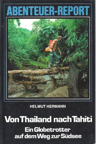
Von Thailand nach Tahiti. Ein Globetrotter auf dem Weg zur S�dsee
Published by Franz Schneider Verlag, 1982
ISBN 10: 3505073245 ISBN 13: 9783505073243
Language: German
First Edition
US$ 8.35
Convert currencyUS$ 19.97 shipping from Germany to U.S.A.Quantity: 1 available
Add to basketSoftcover. Condition: Gut bis sehr gut. 1. Auflage. Paperback mit Folie, abwischbar, stabil, ausgeschiedenes Bibl.-Ex., sehr gut erh., mit Lichtbildern u. Karten, Fahrrad, helicat und bemo - Verkehrsmittel in Jakarta. 400 km in der 3. Klasse von Bandung nach Jogjakarta; Abenteuer-Report, 235 S.; sofort lieferbar.
-

US$ 12.10
Convert currencyUS$ 14.10 shipping from Germany to U.S.A.Quantity: 1 available
Add to basketCondition: Gut. Zabern, Mainz 1980. 292 S. mit zahlr. teils farb. Taf. u. Abb. Gr.-8�. Ppbd. ? Austellung in Linden-Museum, Stuttgart 1980. 83571 / 19169 Mit Ausnahme von Direkt-Recycling Materialien erfolgt der Versand ohne Einsatz von Kunststoffen. Sprache: Deutsch.
-
Buddhas, G�tter, Helden, D�monen. Ausstellungskatalog Linden-Museum, Stuttgart u.a. Mainz, Zabern, 1980. 4to. Mit 24 Farbtafeln u. 275 Abbildungen. 292 S. Farbiger Or.-Pp. (ISBN 3805304552).
Seller: J�rgen Patzer, Konstanz, Germany
Association Member: GIAQ ILAB VDA
Seller rating 4 out of 5 stars

US$ 12.10
Convert currencyUS$ 22.32 shipping from Germany to U.S.A.Quantity: 1 available
Add to basket -
Buddhas, G�tter, Helden, D�monen. Ausstellungskatalog Linden-Museum, Stuttgart u.a. Mainz, Zabern, 1980. 4to. Mit 24 Farbtafeln u. 275 Abbildungen. 292 S. Or.-Pp. (ISBN 3805304552).
Seller: J�rgen Patzer, Konstanz, Germany
Association Member: GIAQ ILAB VDA
Seller rating 4 out of 5 stars
US$ 14.52
Convert currencyUS$ 22.32 shipping from Germany to U.S.A.Quantity: 1 available
Add to basket -
Motor Touring Guide Java, Bali. Orig. edn.
Seller: Antiquarianbooksellers GEMILANG, Bredevoort, Netherlands
Seller rating 2 out of 5 stars

US$ 42.35
Convert currencyUS$ 23.49 shipping from Netherlands to U.S.A.Quantity: 1 available
Add to basketJakarta, 1978. Tall slim large 8�, pictorial coloured wraps., 4 folded coloured roadmaps with plans of Bandung, Jakarta, Semarang, Surabaya, Den Pasar on versos, with legenda, folded leave with coloured traffic-signs with explanations, table of distances, coloured adverts. Motoring in Java and on Bali, suppl. ample useful information. Good copy.
-
Java Bali Motor Touring Guide. Cetakan ke VI [6th updated edition].
Seller: Antiquarianbooksellers GEMILANG, Bredevoort, Netherlands
Seller rating 2 out of 5 stars
US$ 54.44
Convert currencyUS$ 23.49 shipping from Netherlands to U.S.A.Quantity: 1 available
Add to basketJakrta-Surabaya-Semarang, Pembina, [circa], 1995. Narrow tall 8�. Original limp glossy illustrated wrappers. Frontcover title in bold black type, wrap-around coloured illustration of a Javanese countryside with a road and motorvehicles. 6 extending yellow coloured city maps printed on 3 leaves (recto/verso), including streetnames printed, featuring Jakarta andBandung, Semarang and Yogyakarta, Surabaya and Den Pasar, each map with marginal coloured illustrations, Extending and detailed map of Java with map of Bali on verso of Java map, table of distances in kam., some illustrations of local indigenous craftsmen/women, many coloured road-and traffic sings, with captions and legenda, printed on a single extending leave at rear end, some sponsoring ads. insode both covers. English language collection of city maps from Java and Bali which include streetnames printed on maps, on behalf of motorists touring Java and Bali. Good to very good copy.
-
![Seller image for Jamaica and Java [and Bali]. for sale by Asia Bookroom ANZAAB/ILAB](https://pictures.abebooks.com/inventory/md/md31025630967.jpg)
Jamaica and Java [and Bali].
Published by [Encyclopedia Britannica] [circa1900]., [London and New York.], 1900
Seller: Asia Bookroom ANZAAB/ILAB, Canberra, ACT, Australia
Association Member: ANZAAB ILAB
Seller rating 5 out of 5 stars

US$ 50.94
Convert currencyUS$ 30.00 shipping from Australia to U.S.A.Quantity: 1 available
Add to basketMap in three insets, after W & AK Johnston, engravers with printed outline colour, 18.9 x 28.9 cm, central fold, paper age-toned, but in very good condition. Interesting map which first appeared in the ninth edition of Encyclopedia Britannica.
-
Toeristenkaart van Bali en het Idjen-Hoogland. Uitgegeven door de J.M.C. De Koninklijke Vereeniging Java Motor Club.in samenwerking met de Officie�le Vereeniging voor Toeristenverkeer Batavia-C. Orig. edn.
Seller: Antiquarianbooksellers GEMILANG, Bredevoort, Netherlands
Seller rating 2 out of 5 stars
US$ 175.43
Convert currencyUS$ 23.49 shipping from Netherlands to U.S.A.Quantity: 1 available
Add to basketSemarang-Batavia-C., Java Motor Club/Vereeniging Toeristenverkeer, � [.], 1932. Very large multiple folded coloured map of Bali and Idjen Highlands (Java), 1:250.000, total size 100x80cm. Extensive key to map printed at lower left corner of map, with extra dutch language elucidating text also printed at tail. Map between original grey coloured, limp wrappers, title on front wrapper with Java Motor Club logo in upper left corner. Ample detailed tourist map to Bali and the Idjen Highland mountain range, Java, well-knowt to both inland and foreign visitors. Very good copy. Rare.
-
1st edn.
Seller: Antiquarianbooksellers GEMILANG, Bredevoort, Netherlands
Seller rating 2 out of 5 stars
US$ 272.22
Convert currencyUS$ 23.49 shipping from Netherlands to U.S.A.Quantity: 1 available
Add to basketBandoeng, Nix. c. 1930. Small 8�, blue lettered cloth double portfolio. List of contents printed inside upper boards, explanation of legenda printed inside lower boards. Contains tog. 9 very fine folded coloured maps (varying in size), all with legenda, linen-backed. Scale 1:500.000. With table of distances (map no. 10). Maps 1-6 listing tog. 819 estates (mainly sugar, coffee, rubber, tea, etc.) printed on versos of maps. A very fine set of coloured maps. (portfol. somewh. soiled.).


