
Order Total (1 Item Items):
Shipping Destination:

Kaerius (99 results)
Author:
kaerius
Refine with Advanced Search
Skip to main search results
Search filters
Product Type
- All Product Types
- Books (53)
- Magazines & Periodicals (No further results match this refinement)
- Comics (No further results match this refinement)
- Sheet Music (No further results match this refinement)
- Art, Prints & Posters (8)
- Photographs (No further results match this refinement)
- Maps (38)
- Manuscripts & Paper Collectibles (No further results match this refinement)
Condition Learn more
- New (No further results match this refinement)
- As New, Fine or Near Fine (20)
- Very Good or Good (13)
- Fair or Poor (No further results match this refinement)
- As Described (66)
Binding
Collectible Attributes
- First Edition (10)
- Signed (No further results match this refinement)
- Dust Jacket (3)
- Seller-Supplied Images (93)
- Not Print on Demand (99)
Language (4)
Free Shipping
- Free Shipping to U.S.A. (No further results match this refinement)
Seller Location
Seller Rating
-

Handkolorierter Orig.-Kupferstich mit gelb gerahmter Titelkartusche von P. Kaerius mit zwei Segelschiffen und einem Boot. Amsterdam: C. J. Visscher, 1649 (aus: Tabulae Geographicae Contrare). - Motiv: 8,5 x 12,5 auf Blatt "103": 10,5 x 15,5 cm. * Miniature map of the Island of Mozambique, off northern Mozambique, between the Mozambique Channel and Mossuril Bay, and is part of Nampula Province. Oriented to the West. With a netherlands text versus: "Beschryvinge van't Punt van Africa". - Koeman III, 8830:341, ed. 341:54 (1649 Tabulae, Visscher).
-

"Wirtenberg Ducatus" - Baden W�rttemberg Stuttgart Neuenstadt am Kocher Heilbronn Karte map
Language: Latin
Published by Amsterdam, 1616
Seller: Antiquariat Steffen V�lkel GmbH, Seubersdorf, Germany
Seller rating 5 out of 5 stars

Map
OriginalKupferstich aus dem St�dte-Atlas von Bertius von 1616. R�ckseitig mit Text. -- Blattmasse: ca.17,5 x23 cm. -- leicht fleckig, sonst gut erhalten. || Original copper engraving out of Bertius' city atlas from 1616. With text on verso. -- slightly stained, otherwise in good condition. // Wir, das Antiquariat Steffen V�lkel, kaufen und verkaufen alte B�cher, Handschriften, Zeichnungen, Autographen, Grafiken und Fotografien. Wir sind stets am Ankauf von kompletten Bibliotheken, Sammlungen und Nachl�ssen interessiert. la Gewicht in Gramm: 10.
-
Praecipuarum urbium Germaniae superioris iconismi & effigies, graphice delineatae (Umschlag: Kaerius St�dtebilder).
Published by Unterschneidheim, Verlag Walter Uhl, 1972 (Nachdruck der Ausgabe Amsterdam, 1619)., 1972
Seller: Versandantiquariat Wolfgang Friebes, Graz, Austria
Seller rating 5 out of 5 stars
First Edition
Condition: 0. Erste Ausgabe dieses Nachdruckes mit einem neuen zweiseitigen Vorwort. - Umschlag etw. fleckig u. tlw. leicht berieben. ge Gewicht in Gramm: 500 Qu.-Gr.-8�. 56 nn. Bll., OLwd. m. illustr. OUmschlag.
-
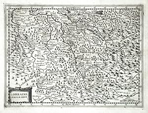
Lorraine vers le midy
Published by Jan Janssonius, Amsterdam, 1673
Seller: Antikvariat Krenek, Prag, Czech Republic
Association Member: ILAB
Seller rating 5 out of 5 stars
Map
US$ 74.27
US$ 16.72 shipping
Ships from Czech Republic to U.S.A.Quantity: 1 available
Add to basketKein Einband. Condition: Gut bis sehr gut. Lorraine. "Lorraine vers le midy". Orig. copperplate engraving by P. van den Keere. Published by J. Janssonius van Waesbergen in Amsterdam, 1673. With ornamental title cartouche. 18:24,5 cm (7 x 9 3/4 inch.). Koeman III, map 4252:353, ed. 353:21 (1673). - A miniatrure map of South Lorraine, a region in north-eastern France.
-
Germania Inferior id est, XVII Provinciarum ejus novae et exactae Tabulae Geographicae, cum Luculentis Singularum descriptionibus additis.
Published by Amsterdam, Theatrum Orbis Terrarum 1966, 1966
Seller: Antiquariaat Pieter Judo (De Lezenaar), Hasselt, Belgium
Association Member: ILAB
Seller rating 5 out of 5 stars
xviii + 93pp.+ 24 double-page engraved maps, with engraved titlepage, Facsimile of the 1617-Amsterdam-edition, green cloth, dustwrapper, 45cm., in the series "Theatrum Orbis Terrarum. Third series of atlases in facsimile" vol.3.
-
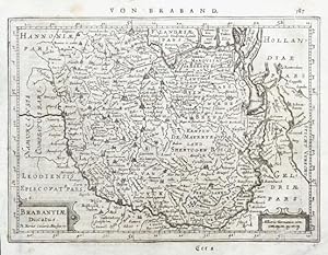
Brabantiae Ducatus
Published by Jan Janssonius, Amsterdam, 1648
Seller: Antikvariat Krenek, Prag, Czech Republic
Association Member: ILAB
Seller rating 5 out of 5 stars
Map
US$ 79.21
US$ 16.72 shipping
Ships from Czech Republic to U.S.A.Quantity: 1 available
Add to basketKein Einband. Condition: Gut bis sehr gut. Brabant. "Brabantiae Ducatus". Orig. copperplate engraving, P. Kaerius (van der Keere). Published by J. Janssonius in Amsterdam, 1648-51. With ornamental title-cartouche, another cartouche with the scale of map ("Milliaria Germanica com.") and German title above the map ("Von Braband"). 15:20,5 cm (6 x 8 inch.). Koeman III, map 3100:352.1, ed. 352:32/33 (1648-51 German). - A miniature map of Brabant.
-

Dominium Venetum in Italia
Published by Veneto
Seller: Sergio Trippini, Gavirate, VA, Italy
Seller rating 4 out of 5 stars

Elegante carta geografica dello Stato Veneto delimitata da un doppio rigo e dal bordo graduato con l'indicazione della latitudine e della longitudine. Arricchita da due cartigli con il titolo e la scala delle distanze, la piccola mappa presenta un'accurata descrizione dell'apparato fluviale e una ricca toponomastica. Si tratta della versione della mappa inizialmente contenuta nell'Atlas Minor del Mercator-Hondius del 1607 qui incisa da Petrus Kaerius (firma in basso a destra) per l'edizione dell'atlante tascabile di Johannes Janssonius pubblicato nel 1648.Nel 1607 Jodocus Hondius pubblica per la prima volta una versione tascabile dell'Atlas di Gerard Mercator nominandolo appunto Atlas Minor: le mappe si basano in parte sul lavoro Mercatoriano del 1580-90 e in parte sulle mappe dello stesso Hondius pubblicate nel 1606. L'enorme popolarit� del formato ridotto e il prezzo inferiore rispetto agli atlanti in folio si riflett� in un enorme successo editoriale e alla pubblicazione di continui aggiornamenti ed arricchimenti. Nel 1648 Janssonius, per il suo atlante tascabile, commissiona una nuova serie di carte geografiche incise da Pieter Van Den Keere (Kaerius) e Abraham Goos due fra i pi� validi incisori olandesi dell'epoca; queste eleganti carte di questa edizione del 1648 sorprendono, data la ridotta dimensione, per la ricchezza del dettaglio a livello decorativo (cartigli, navi, rose dei venti ecc.) e per la precisione cartografica nei rilievi. Autore: Kaerius Petrus. Luogo: Veneto. Anno: 1648. Tecnica: incisione in rame. Dimensioni: 155x204 mm.
-
[Leo Belgicus] Germania Inferior id est, XVII provinciarum ejus novae et exactae tabulae geographicae, cum Luculentis Singularum additais . . . 1622
Published by Petrus Kaerius, 1622
Seller: Barry Lawrence Ruderman, La Jolla, CA, U.S.A.
Seller rating 5 out of 5 stars
Hardcover. Condition: vg+. The First Folio Atlas of the Low Countries. With the Famed Leo Belgicus Map.Second Latin edition of the first atlas exclusively devoted to the Seventeen Provinces.The atlas includes a finely engraved title replete with a. Folio. Contemporary stiff vellum with manuscript title to spine reading "Kaerii | German | Inferior." Complete with 24 double-page engraved maps and one double-page engraved plate. (Minor staining to vellum. Corner of X and Kk2 torn, latter including loss to image. Some internal edge fraying of paper. Final blank repaired. Small paste-down to spine. Deaccession stamp to front blank.) The First Folio Atlas of the Low Countries. With the Famed Leo Belgicus Map.Second Latin edition of the first atlas exclusively devoted to the Seventeen Provinces.The atlas includes a finely engraved title replete with allegorical representations of the arts of printing and navigation, the coats of arms of each of the XVII Provinces, and a skull on a sundial acting representing a vanitas motif. Following this are the maps, with 24 double-paged maps embellished with decorative cartouches and small-town views (including the Leo Belgicus map) and a historical plate with views of the local customs.For this 1622 edition (following the 1617 first edition), Petrus Kaerius (also known as Pieter van den Keere) invited Ghent-born Petrus Montanus or Van den Berghe to write the accompanying text to his maps. Montanus was married to a sister of Jodocus Hondius senior, who was in turn also Kaerius' brother-in-law. As such, the text was entirely reset. In addition, "Flandriae pars orientalior" (pl. 10) was replaced by the "Caerte van 't Vrije" by C.J. Visscher while the map "Typus Frisiae orientalis," now with text on the verso, is bound at the end.Leo BelgicusIn addition to being the first folio atlas of the Low Countries, the atlas is perhaps most famous for its inclusion of the second state of Kaerius' Leo Belgicus map, showing the Low Countries in the shape of a rampant lion facing Europe to the right, engraved by Hendrik van Langren (1573-1609).The Leo Belgicus maps are perhaps the most famous examples of cartography as an expression of national pride. The use of the lion image was also suggested by the vaguely leonine shape of the areas themselves. Further, the lion had long figured in the national iconography of Holland and Belgium; most of the coats-of-arms of the countries' Seventeen Provinces feature a lion. Also, the map was a statement of unity, since at the time the Seventeen Provinces comprised a single nation, although under the control of Spain.Petrus KaeriusVan den Keere (Kaerius) was one of the most skilled Flemish engravers of the early 17th century, whose talents were utilized by the English map publisher, John Speed, among others. The Leo Belgicus is perhaps his finest work. Its rich ornamentation includes three couples along the bottom in the characteristic dress of the regions of Friesland, Holland, and Belgium. Tooley notes that Leo Belgicus maps are exceedingly rare, with some examples known in a handful of examples, and in some cases, only a single example.When Kaerius fell on hard times later in the decade, the copper plates for the maps would be sold to Claes Janszoon Visscher.ProvenanceEarly ink ownership to title.Manuscript inscription on verso of first blank reading: "Dan: Part. Ex Biblioth. Prin: Juv: Sept. 13. 1716".Ink stamp on first blank reading: "Released from the Cathedral Library by Authority of the Dean and Chapter Date 22 Dec 1969".Collation[Half-Title]; [Title]; [iv]. Book.
-

Palatinatus Bavariae
Published by Jan Janssonius, Amsterdam, 1673
Seller: Antikvariat Krenek, Prag, Czech Republic
Association Member: ILAB
Seller rating 5 out of 5 stars
Map
US$ 89.11
US$ 16.72 shipping
Ships from Czech Republic to U.S.A.Quantity: 1 available
Add to basketKein Einband. Condition: Gut bis sehr gut. Oberpfalz (Bayern). "Palatinatus Bavariae". Orig. Kupferstich Karte von P. van den Keere bei J. Janssonius van Waesbergen, 1673. Mit ornament. Titelkart. 18,5:25,5 cm. Koeman III, map 2670:353, ed. 353:21 (1673, ohne R�ckseitetext). - Karte von Oberpfalz.
-
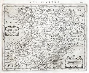
Limburg Ducatus
Published by Jan Janssonius, Amsterdam, 1648
Seller: Antikvariat Krenek, Prag, Czech Republic
Association Member: ILAB
Seller rating 5 out of 5 stars
Map
US$ 89.11
US$ 16.72 shipping
Ships from Czech Republic to U.S.A.Quantity: 1 available
Add to basketKein Einband. Condition: Gut bis sehr gut. Limburg. "Limburg Ducatus". Orig. copperplate engraving, P. Kaerius (van der Keere). Published by J. Janssonius in Amsterdam, 1648-51. With ornamental title cartouche, another cartouche with the scale of map ("Milliaria Germanica . Gallica communia") and German title above the map ("Von Limburg"). 16:20 cm (6 1/4 x 8 inch.). Koeman III, map 3170:352.1, ed. 352:32/33 (1648-51 German). - A miniature map of Limburg. - Left margin tightly trimmed and set with contemporary paper.
-
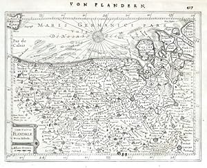
Comitatus Flandriae Nova Tabula
Published by Jan Janssonius, Amsterdam, 1648
Seller: Antikvariat Krenek, Prag, Czech Republic
Association Member: ILAB
Seller rating 5 out of 5 stars
Map
US$ 89.11
US$ 16.72 shipping
Ships from Czech Republic to U.S.A.Quantity: 1 available
Add to basketKein Einband. Condition: Gut bis sehr gut. Flanders. "Comitatus Flandriae Nova Tabula". Orig. copperplate engraving, P. Kaerius (van der Keere). Published by J. Janssonius in Amsterdam, 1648-51. With ornamental title cartouche with the scale of map ("Milliaria Germanica") and German title above the map ("Von Flandern"). 15,5:20,5 cm (6 1/4 x 8 inch.). Koeman III, map 3200:352.1, ed. 352:32/33 (1648-51 German). - A miniature map of Flanders.
-

Bavaria Ducatus
Published by Jan Janssonius, Amsterdam, 1673
Seller: Antikvariat Krenek, Prag, Czech Republic
Association Member: ILAB
Seller rating 5 out of 5 stars
Map
US$ 89.11
US$ 16.72 shipping
Ships from Czech Republic to U.S.A.Quantity: 1 available
Add to basketKein Einband. Condition: Gut bis sehr gut. Bayern. "Bavaria Ducatus". Orig. Kupferstich Karte von P. van den Keere bei J. Janssonius van Waesbergen, 1673. Mit ornament. Titelkart. 18,5:25,5 cm. Koeman III, map 2660:353.1, ed. 353:21 (1673, ohne R�ckseitetext). - Karte von Bayern.
-
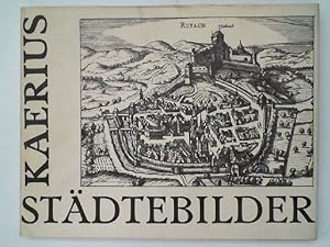
Praecipuarum urbium Germaniae Superioris Iconismi et effigies, Graphice delineatae. St�dtebilder.
Language: German
Published by Unterschneidheim, Vlg. Walter Uhl, 1972
gebundene Ausgabe, Condition: Gut. Reprint. Mit 107 Ansichten Schutzumschlag gebr�unt und mit Knickspuren am Rand, in gutem Zustand, KU-3003 Auf Grund der EPR-Regelung kann zur Zeit kein Versand mehr in folgende L�nder erfolgen: Spanien, Polen, Bulgarien, D�nemark, Estland, Finnland, Griechenland, Irland, Luxemburg, Portugal, Rum�nien, Schweden, Slowakei, Slowenien, Ungarn, Zypern Sprache: Deutsch Gewicht in Gramm: 550.
-
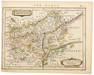
Namurcum Comitatus.
Published by Atlas Minor. Jan Jansson. 1651, 1651
Seller: Peter Harrington. ABA/ ILAB., London, United Kingdom
Association Member: ABA ILAB PBFA
Seller rating 5 out of 5 stars
US$ 82.63
US$ 29.42 shipping
Ships from United Kingdom to U.S.A.Quantity: 1 available
Add to basketBeautiful map of the Namur region of Belgium, from Jansson's edition of Mercator's Atlas Minor. Petrus Kaerius and other cartographers added maps to this and other later editions of the Atlas Minor. Moreland & Bannister, Antique Maps, p.98. Copper engraving. Fine condition. Original colour. Size: 19 x 14 cm. (7� x 5� inches).
-

Monasteriensis Episcopatus
Published by Jan Janssonius, Amsterdam, 1673
Seller: Antikvariat Krenek, Prag, Czech Republic
Association Member: ILAB
Seller rating 5 out of 5 stars
Map
US$ 103.97
US$ 16.72 shipping
Ships from Czech Republic to U.S.A.Quantity: 1 available
Add to basketKein Einband. Condition: Gut bis sehr gut. M�nster. "Monasteriensis Episcopatus". Orig. Kupferstich Karte von P. Kaerius bei J. Janssonius van Waesbergen, 1673. Mit ornament. Titelkart. 18,5:25,5 cm. Koeman III, map 2330:353, ed. 353:21 (1673, ohne R�ckseitetext). - Karte des Bistum M�nster.
-

Loediensis Dioecesis typus
Published by Jan Janssonius, Amsterdam, 1673
Seller: Antikvariat Krenek, Prag, Czech Republic
Association Member: ILAB
Seller rating 5 out of 5 stars
Map
US$ 103.97
US$ 16.72 shipping
Ships from Czech Republic to U.S.A.Quantity: 1 available
Add to basketKein Einband. Condition: Gut bis sehr gut. Liege. "Loediensis Dioecesis typus". Orig. copperplate engraving by P. van den Keere. Published by J. Janssonius van Waesbergen in Amsterdam, 1673. With ornamental title cartouche. 18,5:25 cm. Koeman III, map 3360:353.1, ed. 353:21 (1673, ohne R�ckseitetext). - A miniature map of Diocese Liege in Belgium.
-

Palatinatus Rheni
Published by Jan Janssonius, Amsterdam, 1673
Seller: Antikvariat Krenek, Prag, Czech Republic
Association Member: ILAB
Seller rating 5 out of 5 stars
Map
US$ 103.97
US$ 16.72 shipping
Ships from Czech Republic to U.S.A.Quantity: 1 available
Add to basketKein Einband. Condition: Gut bis sehr gut. Baden-W�rttemberg. "Palatinatus Rheni". Orig. copperplate engraving by P. van den Keere. Published by J. Janssonius van Waesbergen in Amsterdam, 1673. With ornamental title cartouche. 18,5:25 cm. Koeman III, map 2500:353.1, ed. 353:21 (1673, ohne R�ckseitetext). - A miniature map of the northern part of Baden-W�rttembergs with the city of Heidelberg in the centre.
-
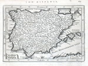
Hispania nova Descript.
Published by Jan Janssonius, Amsterdam, 1628
Seller: Antikvariat Krenek, Prag, Czech Republic
Association Member: ILAB
Seller rating 5 out of 5 stars
Map
US$ 103.97
US$ 16.72 shipping
Ships from Czech Republic to U.S.A.Quantity: 1 available
Add to basketKein Einband. Condition: Gut bis sehr gut. Spain. "Hispania nova Descript.". Orig. copperplate engraving by P. van den Keere (Kaerius). Published in Amsteradam by J. Janssonius, 1648. With ornamental title cartouche, decorative cartouche with the scale of map ("Leucae Hispanicae. Miliaria Germania") and German heading title ("Von Hispania"). 13,5:19,5 cm (5 1/4 x 7 3/4 inch.). Koeman III, map 6000:352.1, ed. 352:32/33 (1648-51 German). - A miniature map of Spain.
-

Saltzburg archiepiscopatus cum ducatu Carinthiae
Published by Jan Janssonius, Amsterdam, 1673
Seller: Antikvariat Krenek, Prag, Czech Republic
Association Member: ILAB
Seller rating 5 out of 5 stars
Map
US$ 103.97
US$ 16.72 shipping
Ships from Czech Republic to U.S.A.Quantity: 1 available
Add to basketKein Einband. Condition: Gut bis sehr gut. Salzburgerland und K�rten. "Saltzburg archiepiscopatus cum ducatu Carinthiae". Orig. Kupferstich Karte von P. van den Keere bei J. Janssonius van Waesbergen, 1673. Mit ornament. Titelkart. 18,5:25,5 cm. Koeman III, map 2720:353.1, ed. 353:21 (1673, ohne R�ckseitetext). - Karte von Salzburgerland und K�rnten.
-

Antique Print-AKEN-AACHEN-VIEW-GERMANY-Kaerius-Guicciardini-c.1610
Published by c.1610, 1610
Seller: Pictura Prints, Art & Books, Overasselt, Netherlands
Seller rating 5 out of 5 stars
Art / Print / Poster
Lodovico Guicciardini (illustrator). 'AKEN.'Original antique print showing a view of Aachen/Aken, Germany.Made by Petrus Kaerius after Lodovico Guicciardini.Medium: Engraving/etching on hand laid (verge) paper.Sheet size: 23.2 x 16.7 cm (9.13 x 6.57 inch). Image size: 19.9 x 11.3 cm. (7.83 x 4.45 inch).AKEN-AACHEN-VIEW-GERMANY | E24-04BACKGROUND INFORMATIONPublished in The Netherlands c. 1610.Biography engraver: Plate engraved by the very skilled Pieter van den Keere or Petrus Kaerius (1571-1646), a Flemish engraver, publisher and globe maker.Biography artist: Lodovico Guicciardini (1521-1589): Italian merchant from aristocratic descent. He was born in Florence, a son of Jacopo Guicciardini. His uncle was the famous author Francesco Guicciardini (1483-1540) who wrote 'La historia di Italia'. The Guicciardini family established a presence in Antwerp and in 1541 Lodovico arrived to work with his uncle. At the same time they functioned as informents for the Medici's back home. He stayed until his death. At one point he was accused with his brother Giovan Battista of killing Gaspare Ducci, who they held resposible for their bancruptcy in 1543. Lodovico apparently started writing in 1552 and in 1556 he published his first work 'Comentarii della.', about European history. In 1567 he got the 'Descrittione.' published. He wrote a few more works. In 1569 he landed in jail because he critisized Alva's policies. In 1582 he landed in jail again because he apparently knew Jean Jaureguy, who tried to kill William of Orange, but he was released soon. Although he had been prosperous at times he ended a poor man. Condition: good, given age. Some damp staining, mostly outside image. General age-related toning and/or occasional minor defects from handling. Please study scan carefully.
-
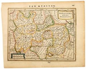
MONASTERIENSIS EPISCOPATUS.
Published by Atlas Minor. Jan Jansson. 1651, 2nd German edition., 1651
Seller: Peter Harrington. ABA/ ILAB., London, United Kingdom
Association Member: ABA ILAB PBFA
Seller rating 5 out of 5 stars
US$ 103.29
US$ 29.42 shipping
Ships from United Kingdom to U.S.A.Quantity: 1 available
Add to basketA delightful map of Holland. From Jansson's edition of Mercator's Atlas Minor. Moreland & Bannister, Antique Maps, p.98. Copper engraving. Fine condition. Original colour. Size: 19 x 15 cm. (7� x 6 inches).
-

Alsatia inferior.
Published by Atlas Minor. Jan Jansson. 1651, 1651
Seller: Peter Harrington. ABA/ ILAB., London, United Kingdom
Association Member: ABA ILAB PBFA
Seller rating 5 out of 5 stars
US$ 103.29
US$ 29.42 shipping
Ships from United Kingdom to U.S.A.Quantity: 1 available
Add to basketBeautiful map of a part of Germany from Jansson's edition of Mercator's Atlas Minor. Maps by other cartographers, including Petrus Kaerius, and Abraham Goos were added to this and other later editions. Moreland & Bannister, Antique Maps, p.98. Copper engraving. Fine condition. Original colour. Size: 19 x 14 cm. (7� x 5� inches).
-

Thuringia.
Published by Atlas Minor. Jan Jansson. 1651, 1651
Seller: Peter Harrington. ABA/ ILAB., London, United Kingdom
Association Member: ABA ILAB PBFA
Seller rating 5 out of 5 stars
US$ 103.29
US$ 29.42 shipping
Ships from United Kingdom to U.S.A.Quantity: 1 available
Add to basketBeautiful map of Thuringia, central Germany, from Jansson's edition of Mercator's Atlas Minor. Maps by other cartographers, including Petrus Kaerius, and Abraham Goos were added to this and other later editions. Moreland & Bannister, Antique Maps, p.98. Copper engraving. Fine condition. Original colour. Size: 19 x 14 cm. (7� x 5� inches).
-

Nova Alemania sive Sveviae Superioris Tabula. (Swabia.)
Published by Atlas Minor. Jan Jansson. 1651, 1651
Seller: Peter Harrington. ABA/ ILAB., London, United Kingdom
Association Member: ABA ILAB PBFA
Seller rating 5 out of 5 stars
US$ 103.29
US$ 29.42 shipping
Ships from United Kingdom to U.S.A.Quantity: 1 available
Add to basketBeautiful map of Swabia, south-west Germany, from Jansson's edition of Mercator's Atlas Minor. Maps by other cartographers, including Kaerius, and Abraham Goos were added to this and other later editions. Moreland & Bannister, Antique Maps, p.98. Copper engraving. Fine condition. Original colour. Size: 19 x 14 cm. (7� x 5� inches).
-

Erpach.
Published by Atlas Minor. Jan Jansson. 1651, 2nd German edition., 1651
Seller: Peter Harrington. ABA/ ILAB., London, United Kingdom
Association Member: ABA ILAB PBFA
Seller rating 5 out of 5 stars
US$ 103.29
US$ 29.42 shipping
Ships from United Kingdom to U.S.A.Quantity: 1 available
Add to basketBeautiful map of Erpach, showing the region in Germany between the Rhine, Neckar, and Main rivers, including Heidelberg and Erpach, from Jansson's edition of Mercator's Atlas Minor. Maps by other cartographers, including Petrus Kaerius, and Abraham Goos were added to this and other later editions. Moreland & Bannister, Antique Maps, p.98. Copper engraving. Fine condition. Original colour. Size: 19 x 14 cm. (7� x 5� inches).
-

Alsatia superior.
Published by Atlas Minor. Jan Jansson. 1651, 1651
Seller: Peter Harrington. ABA/ ILAB., London, United Kingdom
Association Member: ABA ILAB PBFA
Seller rating 5 out of 5 stars
US$ 103.29
US$ 29.42 shipping
Ships from United Kingdom to U.S.A.Quantity: 1 available
Add to basketBeautiful map of Alsace from Jansson's edition of Mercator's Atlas Minor. Maps by other cartographers, including Petrus Kaerius, and Abraham Goos were added to this and other later editions. Moreland & Bannister, Antique Maps, p.98. Copper engraving. Fine condition. Original colour. Size: 19 x 14 cm. (7� x 5� inches).
-

Coloniensis Archiepiscopatus.
Published by Atlas Minor. Jan Jansson. 1651, 1651
Seller: Peter Harrington. ABA/ ILAB., London, United Kingdom
Association Member: ABA ILAB PBFA
Seller rating 5 out of 5 stars
US$ 103.29
US$ 29.42 shipping
Ships from United Kingdom to U.S.A.Quantity: 1 available
Add to basketBeautiful map of a part of Germany from Jansson's edition of Mercator's Atlas Minor. Maps by other cartographers, including Kaerius, and Abraham Goos were added to this and other later editions. Moreland & Bannister, Antique Maps, p.98. Copper engraving. Fine condition. Original colour. Size: 19 x 14 cm. (7� x 5� inches). Size: 19 x 14 cm. (7� x 5� inches).
-

Holsatia ducatus. (Holstein.)
Published by Atlas Minor. Jan Jansson. 1651, 1651
Seller: Peter Harrington. ABA/ ILAB., London, United Kingdom
Association Member: ABA ILAB PBFA
Seller rating 5 out of 5 stars
US$ 103.29
US$ 29.42 shipping
Ships from United Kingdom to U.S.A.Quantity: 1 available
Add to basketBeautiful map of Holstein from Jansson's edition of Mercator's Atlas Minor. Maps by other cartographers, including Petrus Kaerius, and Abraham Goos were added to this and other later editions. Moreland & Bannister, Antique Maps, p.98. Copper engraving. Fine condition. Original colour. Size: 19 x 14 cm. (7� x 5� inches).
-

Totius Sveviae Novissima tabula.
Published by Atlas Minor. Jan Jansson. 1651, 1651
Seller: Peter Harrington. ABA/ ILAB., London, United Kingdom
Association Member: ABA ILAB PBFA
Seller rating 5 out of 5 stars
US$ 103.29
US$ 29.42 shipping
Ships from United Kingdom to U.S.A.Quantity: 1 available
Add to basketBeautiful map of Swabia, Germany, from Jansson's edition of Mercator's Atlas Minor. Maps by other cartographers, including Petrus Kaerius, and Abraham Goos were added to this and other later editions. Moreland & Bannister, Antique Maps, p.98. Copper engraving. Fine condition. Original colour. Size: 19 x 14 cm. (7� x 5� inches).
-

Hassia Landgraviatus.
Published by Atlas Minor. Jan Jansson. 1651, 1651
Seller: Peter Harrington. ABA/ ILAB., London, United Kingdom
Association Member: ABA ILAB PBFA
Seller rating 5 out of 5 stars
US$ 103.29
US$ 29.42 shipping
Ships from United Kingdom to U.S.A.Quantity: 1 available
Add to basketBeautiful map of the Hesse region in central Germany from Jansson's edition of Mercator's Atlas Minor. Maps by other cartographers, including Petrus Kaerius, and Abraham Goos were added to this and other later editions. Moreland & Bannister, Antique Maps, p.98. Copper engraving. Fine condition. Original colour. Size: 19 x 14 cm. (7� x 5� inches).

![Seller image for [Leo Belgicus] Germania Inferior id est, XVII provinciarum ejus novae et exactae tabulae geographicae, cum Luculentis Singularum additais . . . 1622 for sale by Barry Lawrence Ruderman](https://pictures.abebooks.com/inventory/md/md32446614500.jpg)