
Order Total (1 Item Items):
Shipping Destination:

Larbitray (1 results)
Author:
larbitray
Refine with Advanced Search
Skip to main search results
Search filters
Product Type
- All Product Types
- Books (1)
- Magazines & Periodicals (No further results match this refinement)
- Comics (No further results match this refinement)
- Sheet Music (No further results match this refinement)
- Art, Prints & Posters (No further results match this refinement)
- Photographs (No further results match this refinement)
- Maps (No further results match this refinement)
- Manuscripts & Paper Collectibles (No further results match this refinement)
Condition Learn more
- New (No further results match this refinement)
- As New, Fine or Near Fine (No further results match this refinement)
- Very Good or Good (No further results match this refinement)
- Fair or Poor (No further results match this refinement)
- As Described (1)
Binding
- All Bindings
- Hardcover (1)
- Softcover (No further results match this refinement)
Collectible Attributes
- First Edition (No further results match this refinement)
- Signed (No further results match this refinement)
- Dust Jacket (No further results match this refinement)
- Seller-Supplied Images (1)
- Not Print on Demand (1)
Language (1)
Price
- Any Price
- Under US$ 25 (No further results match this refinement)
- US$ 25 to US$ 50 (No further results match this refinement)
- Over US$ 50
Free Shipping
- Free Shipping to U.S.A. (No further results match this refinement)
Seller Location
Seller Rating
-
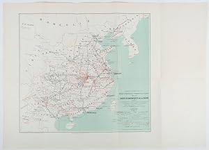
Carte �conomique commerciale en Chine 1895-1897. Chambre de Commerce de Lyon. Mission d'exploration commerciale en Chine.
Published by Erhard Fr�res, Paris., 1898
Seller: Asia Bookroom ANZAAB/ILAB, Canberra, ACT, Australia
Association Member: ANZAAB ILAB
Seller rating 5 out of 5 stars

Lithographed folding colour map 44.5 x 49.5 cms; 54.6 x 76.3 cms (sheet), towns and cities, items of production and trade routes highlighted in red, original folds, in very good, clean condition. Detailed map prepared for the Lyon Chamber of Commerce Mission to China under the direction of a young Henri Brenier (1867-1962), with the purpose of advancing French colonial expansion, and shoring up the interests of the dominant Lyon silk trade. The map shows the principal centres of population, production, waterways, roads, telegraph lines and railroads, togther with the centres of production and distribution for coal, iron, tin, gold and silver, opium, tea, rice, sugar, peanuts, cinnamon, wool, medicinal plants and leather. The trade mission was organized following the Treaty of Shimonoseki and the end of the Sino-Japanese War: the Chamber of Commerce of Lyon understood that end of this war would signal a profound economic development and change.