Order Total (1 Item Items):
Shipping Destination:

Letts Thomas (265 results)
Skip to main search results
Search filters
Product Type
- All Product Types
- Books (48)
- Magazines & Periodicals (No further results match this refinement)
- Comics (No further results match this refinement)
- Sheet Music (No further results match this refinement)
- Art, Prints & Posters (No further results match this refinement)
- Photographs (No further results match this refinement)
- Maps (216)
- Manuscripts & Paper Collectibles (1)
Condition Learn more
- New (2)
- As New, Fine or Near Fine (11)
- Very Good or Good (225)
- Fair or Poor (No further results match this refinement)
- As Described (27)
Binding
Collectible Attributes
- First Edition (10)
- Signed (No further results match this refinement)
- Dust Jacket (No further results match this refinement)
- Seller-Supplied Images (251)
- Not Print on Demand (263)
Language (2)
Free Shipping
Seller Location
Seller Rating
-

Short Story International (Student Series)
Language: English
Published by International Cultural Exchange, Inc., 1994
ISBN 10: 1555731201 ISBN 13: 9781555731205
Condition: Good. Pages intact with minimal writing/highlighting. The binding may be loose and creased. Dust jackets/supplements are not included. Stock photo provided. Product includes identifying sticker. Better World Books: Buy Books. Do Good.
-

Pioneers;: Narratives of Noah Harris Letts and Thomas Allen Banning, 1825-1865 (Lakeside classics)
Published by Lakeside Press / R. R. Donnelley & Sons
Hardcover. Condition: Good. No Jacket. Pages can have notes/highlighting. Spine may show signs of wear. ~ ThriftBooks: Read More, Spend Less.
-
Pioneers: the Narratives of Noah Harris Letts and Thomas Allen Banning, 1825-1865
Published by Lakeside Press, 1972
Seller: Midtown Scholar Bookstore, Harrisburg, PA, U.S.A.
Seller rating 5 out of 5 stars

Hardcover. Condition: Good. No dust jacket. Good hardcover with some shelfwear; may have previous owner's name inside. Standard-sized.
-
Pioneers: Narratives of Noah Harris Letts and Thomas Banning
Language: English
Published by Lakeside Press, CHICAGO, 1972
First Edition
Hardcover. Condition: Good+. Dust Jacket Condition: None. 1st Edition. HC without DJ, 8vo, 290 pages (VG-; corners bumped, crease length of spine cloth.).
-
Pioneers: Narratives of Noah Harris Letts and Thomas Allen Banning, 1825-1865
Language: English
Published by Lakeside Press, Chicago, IL, 1972
Seller: Dorley House Books, Inc., Hagerstown, MD, U.S.A.
Seller rating 4 out of 5 stars

First Edition
Hardcover. Condition: Near Fine. B/W Illus (illustrator). 1st. First Edition, Thus, limited edition; navy c; top edge gilt; 290 clean, unmarked pages.
-
Pioneers: Narratives of Noah Harris Letts and Thomas Allen Banning, 1825- 1865
Language: English
Published by Lakeside Press, Chicago, IL, 1972
Seller: Dorley House Books, Inc., Hagerstown, MD, U.S.A.
Seller rating 4 out of 5 stars
First Edition
Hardcover. Condition: Near Fine. B/W Illus (illustrator). 1st. First Edition, Thus, limited edition; navy c; top edge gilt; 290 clean, unmarked pages.
-
Pioneers: the Narratives of Noah Harris Letts and Thomas Allen Banning, 1825-1865
Published by Lakeside Press
Seller: Wonder Book, Frederick, MD, U.S.A.
Seller rating 5 out of 5 stars
Condition: Very Good. Very Good condition. No Dust Jacket (American Frontier, Pioneer Life, History) A copy that may have a few cosmetic defects. May also contain a few markings such as an owner's name, short gifter's inscription or light stamp.
-
Pioneers: Narratives of Noah Harris Letts and Thomas Allen Banning,Lakeside Classic 1972
Published by R. R. Donnelley 1972 Chicago, 1972
Seller: Prairie Archives, Springfield, IL, U.S.A.
Association Member: MWABA
Seller rating 4 out of 5 stars
vg+, issued w/o dj Cloth Top edges gilt.
-
Pioneers; Narratives of Noah Harris Letts and Thomas Allen Banning
Published by Lakeside Press, Chicago, 1972
Seller: James & Mary Laurie, Booksellers A.B.A.A, Minneapolis, MN, U.S.A.
Association Member: ABAA ILAB MWABA
Seller rating 4 out of 5 stars
Hardcover. Condition: Near fine. Bound in the publisher's original blue cloth, cover and spine stamped in gilt. Black & white illustrations throughout. Lightly rubbed at the extremities. No. 70 of the Lakeside Classics. Edited by Paul M. Angle.
-

Pioneers: Narratives of Noah Harris Letts and Thomas Allen Banning 1825-1865
Published by The Lakeside Press, Chicago, IL, 1972
Seller: Jeff Hirsch Books, ABAA, Wadsworth, IL, U.S.A.
Association Member: ABAA ILAB MWABA
Seller rating 5 out of 5 stars
First Edition
First edition thus. Hardcover. 290 pages. The 70th entry in the longstanding series of books issued by the R.R. Donnelley & Sons Company as a Christmas gift for employees and friends of the press. Edited by Paul Angle. A near fine copy in blue cloth binding without dust jacket as issued. No dust jacket as issued.
-

Two Oxfordshire Anglo-Saxon Cemeteries: Berinsfield and Didcot (Thames Valley Landscapes Monograph ; No. 8)
Language: English
Published by Oxford Archaeological Unit ; Oxford University Committee for Archaeology, 1995
ISBN 10: 0947816860 ISBN 13: 9780947816865
First Edition
Soft cover. Condition: Good. Hughes; Nichols; and Page (illustrator). 1st Edition. Volume has wear and smells a bit like mothballs; tight, text clean. xviii, 274 p., illustrated. Oversize [otob: 20a].
-
Pioneers: Narratives of Noah Harris Letts and Thomas Allen Banning, 1825-1865
Published by Lakeside Press/R.R. Donnelley
First Edition
Hardcover. Condition: Very Good. First Thus. First Edition Thus, First Printing. Published by Lakeside Press/R.R. Donnelley, 1972. Octavo. Blue cloth boards stamped in gold with gilt topstain. Book is very good; with no writing or names. Sharp corners and spine straight. Binding tight and pages crisp. Boards have light shelf wear with very light spotting to page ends. Book placed in custom acetate protector. 290 pages. 100% positive feedback. 30 day money back guarantee. NEXT DAY SHIPPING! Excellent customer service. Please email with any questions or if you would like a photo. All books packed carefully and ship with free delivery confirmation/tracking. All books come with free bookmarks. Ships from Southampton, New York. We Buy Books! Individual titles, libraries, collections. Message us if you have books to sell!
-
PIONEERS: Narratives of Noah Harris Letts and Thomas Allen Banning, 1825-1865
Published by The Lakeside Press (R.R. Donnelly & Sons Company), Chicago, 1972
Seller: Kubik Fine Books Ltd., ABAA, Dayton, OH, U.S.A.
Association Member: ABAA ILAB IOBA MWABA
Seller rating 5 out of 5 stars
Hardcover. Condition: As New. 290p. A navy blue cloth hardcover book with a gilt top edge. Fine condition, clean and tight. A volume in the Lakeside Classics series.
-
Pioneers: Narratives of Noah Harris Letts and Thomas Allen Banning, 1825-1865 (The Lakeside Classics)
Published by The Lakeside Press / R.R. Donnelley & Sons, Chicago, 1972
Seller: Between the Covers-Rare Books, Inc. ABAA, Gloucester City, NJ, U.S.A.
Association Member: ABAA ESA ILAB IOBA
Seller rating 5 out of 5 stars
Hardcover. Condition: Near Fine. Reprint. 290pp. Edited by Paul M. Angle. Spine slightly cocked, near fine without the dust jacket as issued.
-
PIONEERS Narratives of Noah Harris Letts and Thomas Allen Banning 1825 - 1865
Published by Chicago: Lakeside Press R. R. Donnelley and Sons, 1972
Cloth. Condition: Near Fine. Number 70 in the Lakeside Classics Series. Fine, in original publisher's dark blue cloth, top edge gilt, gilt decoration on front cover and gilt lettering on spine.
-
PIONEERS: Narratives of Noah Harris Letts and Thomas Allen Banning 1825-1865/The Lakeside Classics
Published by The Lakeside Press/R. R. Donnelley & Sons Company, Chicago, IL, 1972
Hardcover. Condition: Near Fine. Dust Jacket Condition: No Dust Jacket. 290 pp. Original blue cloth covers w/ gilt title on spine. Binding lightly soiled. Top edge gilt. Previous owner's name stamp on front blank endpaper. Illust. w/ maps, b/w plates and drawings. Contents nice.
-
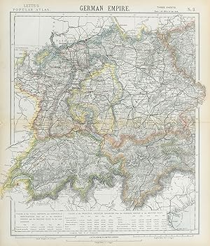
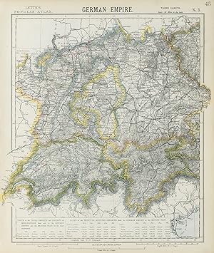
Condition: Good. GERMANY SWITZERLAND AUSTRIA. Baden W�rttemberg Bavaria Tyrol. LETTS 1889 map. Antique colour atlas map; Published by Mason & Payne. Most of the plates used for this atlas were original engraved for the SDUK atlas in the mid nineteenth century. The plates were later sold to Thomas Letts, and subsequently to Mason & Payne (1889). 41.5 x 35.0cm, 16.25 x 13.75 inches. Condition: Good. The image shown may have been taken from a different example of this map than that which is offered for sale. The map you will receive is in good condition but there may be minor variations in the condition from that shown in the image. There is nothing printed on the reverse side, which is plain.
-
Condition: Good. FRANCE SOUTH. Lighthouses. UK-French trade 1876-1880. LETTS 1883 old map. Antique colour atlas map; Published by Letts & Co. Most of the plates used for this atlas were original engraved for the SDUK atlas in the mid nineteenth century. The plates were later sold to Thomas Letts, and subsequently to Mason & Payne (1883). 36.5 x 44.0cm, 14.25 x 17.25 inches; this is a folding map. Condition: Good. The image shown may have been taken from a different example of this map than that which is offered for sale. The map you will receive is in good condition but there may be minor variations in the condition from that shown in the image. There is nothing printed on the reverse side, which is plain.
-
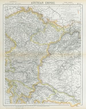
Condition: Good. AUSTRIAN EMPIRE. Bohemia Moravia Styria Illyria Croatia Hungary. LETTS 1883 map. Antique colour atlas map; Published by Letts & Co. Most of the plates used for this atlas were original engraved for the SDUK atlas in the mid nineteenth century. The plates were later sold to Thomas Letts, and subsequently to Mason & Payne (1883). 43.5 x 34.0cm, 17 x 13.5 inches; this is a folding map. Condition: Good. The image shown may have been taken from a different example of this map than that which is offered for sale. The map you will receive is in good condition but there may be minor variations in the condition from that shown in the image. There is nothing printed on the reverse side, which is plain.
-
Condition: Good. NE FRANCE w/o Alsace Lorraine. Champagne Picardy Burgundy Nord.LETTS 1889 map. Antique colour atlas map; Published by Mason & Payne. Most of the plates used for this atlas were original engraved for the SDUK atlas in the mid nineteenth century. The plates were later sold to Thomas Letts, and subsequently to Mason & Payne (1889). 42.5 x 32.0cm, 16.5 x 12.5 inches. Condition: Good. The image shown may have been taken from a different example of this map than that which is offered for sale. The map you will receive is in good condition but there may be minor variations in the condition from that shown in the image. There is nothing printed on the reverse side, which is plain.
-
Condition: Good. FRANCE SOUTH. Lighthouses. UK-French trade 1876-1880. LETTS 1884 old map. Antique colour atlas map; Published by Letts & Co. Most of the plates used for this atlas were original engraved for the SDUK atlas in the mid nineteenth century. The plates were later sold to Thomas Letts, and subsequently to Mason & Payne (1884). 36.0 x 43.0cm, 14.25 x 17 inches. Condition: Good. Tight top margin; The image shown may have been taken from a different example of this map than that which is offered for sale. The map you will receive is in good condition but there may be minor variations in the condition from that shown in the image. There is nothing printed on the reverse side, which is plain.
-
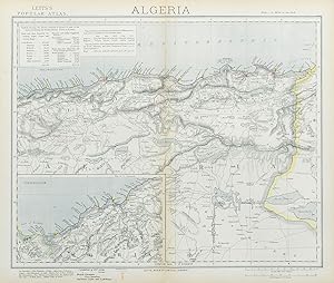
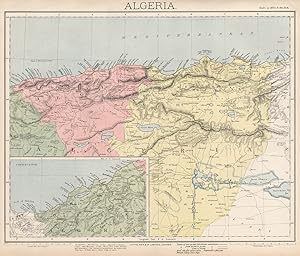
Condition: Good. ALGERIA. North Africa. Algiers Oran Constantine. British Consuls. LETTS 1883 map. Antique colour atlas map; Published by Letts & Co. Most of the plates used for this atlas were original engraved for the SDUK atlas in the mid nineteenth century. The plates were later sold to Thomas Letts, and subsequently to Mason & Payne (1883). 36.0 x 42.5cm, 14.25 x 16.75 inches; this is a folding map. Condition: Good. The image shown may have been taken from a different example of this map than that which is offered for sale. The map you will receive is in good condition but there may be minor variations in the condition from that shown in the image. There is nothing printed on the reverse side, which is plain.
-
Condition: Good. SOUTH GERMANY SWITZERLAND AUSTRIA Baden W�rttemberg Bavaria Tyrol 1883 old map. Antique colour atlas map; Published by Letts & Co. Most of the plates used for this atlas were original engraved for the SDUK atlas in the mid nineteenth century. The plates were later sold to Thomas Letts, and subsequently to Mason & Payne (1883). 43.0 x 36.5cm, 17 x 14.5 inches; this is a folding map. Condition: Good. The image shown may have been taken from a different example of this map than that which is offered for sale. The map you will receive is in good condition but there may be minor variations in the condition from that shown in the image. There is nothing printed on the reverse side, which is plain.
-
Condition: Good. ALGERIA. North Africa. Algier Algiers Oran Constantine. LETTS 1889 old map. Antique colour atlas map; Published by Mason & Payne. Most of the plates used for this atlas were original engraved for the SDUK atlas in the mid nineteenth century. The plates were later sold to Thomas Letts, and subsequently to Mason & Payne (1889). 34.5 x 40.5cm, 13.5 x 16 inches. Condition: Good. The image shown may have been taken from a different example of this map than that which is offered for sale. The map you will receive is in good condition but there may be minor variations in the condition from that shown in the image. There is nothing printed on the reverse side, which is plain.
-
Condition: Good. QUEBEC Qu�bec. St Lawrence lighthouses. Maine.New Brunswick.LETTS 1889 old map. Antique colour atlas map; Published by Mason & Payne. Most of the plates used for this atlas were original engraved for the SDUK atlas in the mid nineteenth century. The plates were later sold to Thomas Letts, and subsequently to Mason & Payne (1889). 35.0 x 41.0cm, 13.75 x 16.25 inches. Condition: Good. The image shown may have been taken from a different example of this map than that which is offered for sale. The map you will receive is in good condition but there may be minor variations in the condition from that shown in the image. There is nothing printed on the reverse side, which is plain.
-
Condition: Good. SOUTH GERMANY SWITZERLAND AUSTRIA Baden W�rttemberg Bavaria Tyrol 1884 old map. Antique colour atlas map; Published by Letts & Co. Most of the plates used for this atlas were original engraved for the SDUK atlas in the mid nineteenth century. The plates were later sold to Thomas Letts, and subsequently to Mason & Payne (1884). 43.0 x 36.5cm, 17 x 14.25 inches. Condition: Good. The image shown may have been taken from a different example of this map than that which is offered for sale. The map you will receive is in good condition but there may be minor variations in the condition from that shown in the image. There is nothing printed on the reverse side, which is plain.
-
Condition: Good. AUSTRIAN EMPIRE. Bohemia Moravia Styria Illyria Croatia Hungary. LETTS 1884 map. Antique colour atlas map; Published by Letts & Co. Most of the plates used for this atlas were original engraved for the SDUK atlas in the mid nineteenth century. The plates were later sold to Thomas Letts, and subsequently to Mason & Payne (1884). 43.5 x 33.5cm, 17 x 13.25 inches. Condition: Good. The image shown may have been taken from a different example of this map than that which is offered for sale. The map you will receive is in good condition but there may be minor variations in the condition from that shown in the image. There is nothing printed on the reverse side, which is plain.
-
Pioneers: Narratives of Noah Harris Letts and Thomas Allen Banning, 1825-1865
Published by R.R. Donnelley & Sons Company, Chicago, 1972
Seller: Main Street Fine Books & Mss, ABAA, Galena, IL, U.S.A.
Association Member: ABAA ILAB MWABA
Seller rating 5 out of 5 stars
Hardcover. Edited by Paul M. Angle. 16mo. Blue cloth with gilt spine lettering and decoration. xxii, 290pp. Top edge gilt. Maps, illustrations. Very good. 70th volume in the "Lakeside Classics" series of annual Christmas keepsakes, largely reprints of rare historical texts. Two pioneering Illinoisan memoirs, published here for the first time.
-
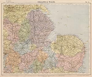
Condition: Good. ENGLAND EAST. Lighthouses East Midlands East Anglia Lincolnshire. LETTS 1889 map. Antique colour atlas map; Published by Mason & Payne. Most of the plates used for this atlas were original engraved for the SDUK atlas in the mid nineteenth century. The plates were later sold to Thomas Letts, and subsequently to Mason & Payne (1889). 34.5 x 41.0cm, 13.5 x 16 inches. Condition: Good. The image shown may have been taken from a different example of this map than that which is offered for sale. The map you will receive is in good condition but there may be minor variations in the condition from that shown in the image. There is nothing printed on the reverse side, which is plain.