Maldives (28 results)

- Softcover
Seller: Revaluation Books, Exeter, , United KingdomRevaluation Books
Contact seller5-star sellerCondition: New
US$ 15.20
US$ 13.45 shippingShips from United Kingdom to U.S.A.Quantity: 1 available
Paperback. Condition: Brand New. 106 pages. 9.00x6.00x0.24 inches. In Stock.

- Softcover
Seller: Revaluation Books, Exeter, , United KingdomRevaluation Books
Contact seller5-star sellerCondition: New
US$ 16.69
US$ 13.45 shippingShips from United Kingdom to U.S.A.Quantity: 1 available
Paperback. Condition: Brand New. 110 pages. 9.00x6.00x0.25 inches. In Stock.
Language: English
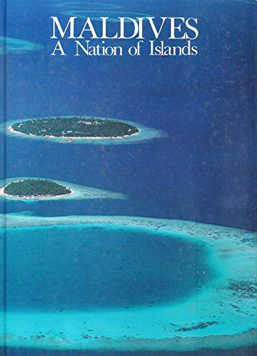
Published by Published by Media Transasia for Dept. of Tourism, Republic of Maldives 1983
- Softcover
Seller: WorldofBooks, Goring-By-Sea, WS, United KingdomWorldofBooks
Contact seller5-star sellerCondition: Used - Very good
US$ 23.91
US$ 7.53 shippingShips from United Kingdom to U.S.A.Quantity: 1 available
Paperback. Condition: Very Good. The book has been read, but is in excellent condition. Pages are intact and not marred by notes or highlighting. The spine remains undamaged.
Language: English
Published by Published by Media Transasia for Dept. of Tourism, Republic of Maldives 1983
- Softcover
Seller: WorldofBooks, Goring-By-Sea, WS, United KingdomWorldofBooks
Contact seller5-star sellerCondition: Used - Fair
US$ 23.91
US$ 7.53 shippingShips from United Kingdom to U.S.A.Quantity: 1 available
Paperback. Condition: Fair. A readable copy of the book which may include some defects such as highlighting and notes. Cover and pages may be creased and show discolouration.

- Softcover
Seller: Revaluation Books, Exeter, , United KingdomRevaluation Books
Contact seller5-star sellerCondition: New
US$ 18.25
US$ 13.45 shippingShips from United Kingdom to U.S.A.Quantity: 1 available
Paperback. Condition: Brand New. 106 pages. 9.00x6.00x0.24 inches. In Stock.

- Softcover
Seller: Revaluation Books, Exeter, , United KingdomRevaluation Books
Contact seller5-star sellerCondition: New
US$ 18.25
US$ 13.45 shippingShips from United Kingdom to U.S.A.Quantity: 1 available
Paperback. Condition: Brand New. 106 pages. 9.00x6.00x0.24 inches. In Stock.

- Softcover
Seller: Revaluation Books, Exeter, , United KingdomRevaluation Books
Contact seller5-star sellerCondition: New
US$ 18.25
US$ 13.45 shippingShips from United Kingdom to U.S.A.Quantity: 1 available
Paperback. Condition: Brand New. 106 pages. 9.00x6.00x0.24 inches. In Stock.

- Softcover
Seller: Revaluation Books, Exeter, , United KingdomRevaluation Books
Contact seller5-star sellerCondition: New
US$ 18.25
US$ 13.45 shippingShips from United Kingdom to U.S.A.Quantity: 1 available
Paperback. Condition: Brand New. 106 pages. 9.00x6.00x0.24 inches. In Stock.

- Softcover
Seller: Revaluation Books, Exeter, , United KingdomRevaluation Books
Contact seller5-star sellerCondition: New
US$ 19.50
US$ 13.45 shippingShips from United Kingdom to U.S.A.Quantity: 1 available
Paperback. Condition: Brand New. 120 pages. 9.00x6.00x0.30 inches. In Stock.

- Softcover
Seller: Revaluation Books, Exeter, , United KingdomRevaluation Books
Contact seller5-star sellerCondition: New
US$ 17.58
US$ 16.81 shippingShips from United Kingdom to U.S.A.Quantity: 1 available
Paperback. Condition: Brand New. 119 pages. 9.00x6.00x0.30 inches. In Stock.

- Softcover
Seller: Revaluation Books, Exeter, , United KingdomRevaluation Books
Contact seller5-star sellerCondition: New
US$ 19.49
US$ 16.81 shippingShips from United Kingdom to U.S.A.Quantity: 1 available
Paperback. Condition: Brand New. 119 pages. 9.00x6.00x0.30 inches. In Stock.

- Softcover
Seller: Revaluation Books, Exeter, , United KingdomRevaluation Books
Contact seller5-star sellerCondition: New
US$ 22.27
US$ 16.81 shippingShips from United Kingdom to U.S.A.Quantity: 1 available
Paperback. Condition: Brand New. 112 pages. 9.00x6.00x0.26 inches. In Stock.

- Softcover
Seller: Revaluation Books, Exeter, , United KingdomRevaluation Books
Contact seller5-star sellerCondition: New
US$ 22.27
US$ 16.81 shippingShips from United Kingdom to U.S.A.Quantity: 1 available
Paperback. Condition: Brand New. 112 pages. 9.00x6.00x0.26 inches. In Stock.

- Softcover
Seller: Revaluation Books, Exeter, , United KingdomRevaluation Books
Contact seller5-star sellerCondition: New
US$ 22.27
US$ 16.81 shippingShips from United Kingdom to U.S.A.Quantity: 1 available
Paperback. Condition: Brand New. 112 pages. 9.00x6.00x0.26 inches. In Stock.

- Softcover
Seller: Revaluation Books, Exeter, , United KingdomRevaluation Books
Contact seller5-star sellerCondition: New
US$ 18.55
US$ 13.45 shippingShips from United Kingdom to U.S.A.Quantity: 1 available
Paperback. Condition: Brand New. 113 pages. French language. 9.00x6.00x0.26 inches. In Stock.

- Softcover
Seller: Revaluation Books, Exeter, , United KingdomRevaluation Books
Contact seller5-star sellerCondition: New
US$ 18.55
US$ 16.81 shippingShips from United Kingdom to U.S.A.Quantity: 1 available
Paperback. Condition: Brand New. 112 pages. French language. 9.00x6.00x0.26 inches. In Stock.

- Softcover
Seller: Revaluation Books, Exeter, , United KingdomRevaluation Books
Contact seller5-star sellerCondition: New
US$ 22.27
US$ 13.45 shippingShips from United Kingdom to U.S.A.Quantity: 1 available
Paperback. Condition: Brand New. 112 pages. French language. 9.00x6.00x0.26 inches. In Stock.

- Softcover
Seller: antoine, wavre, , Belgiumantoine
Contact seller4-star sellerCondition: Used - Fine
US$ 8.61
US$ 26.69 shippingShips from Belgium to U.S.A.Quantity: 1 available
Aucune reliure. Condition: Très Bon État. dépliant de 14 pages en format 16 - 27 cm - cartes et photographies en couleurs - TBE.
 More images
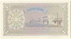
Published by Maldives, Maldives 1960
Seller: biblioboy, North Providence, RI, U.S.A.biblioboy
Contact seller5-star sellerSingle sheet. Maldives: Maldives. 1960. Single sheet. Condition: Uncirculated crisp fresh Banknote as shown The bill is graded by my opinion only. I make no other claims. You, as the buyer are the final judge. What you see is what you get. ; A beautiful uncirculated banknote from the little known Republic of Maldives. A scarcean…d very collectible banknote. .
Seller: Backhuys Biological Books, Kerkwerve, , NetherlandsBackhuys Biological Books
Contact seller5-star sellerCondition: Used
Original price: US$ 28.67; 30% offCurrent price: US$ 20.07
US$ 21.76 shippingShips from Netherlands to U.S.A.Quantity: 1 available
3 wallposters depicting in colour the fishes found in this interesting Archipelago 0.0.
Published by SD
Seller: LiLi - La Liberté des Livres, CANEJAN, , FranceLiLi - La Liberté des Livres
Contact seller5-star sellerCondition: Used - Very good
US$ 5.38
US$ 75.42 shippingShips from France to U.S.A.Quantity: 1 available
Condition: Assez bon.
 More images
Published by Marine Research Section, Ministry of Fisheries and Agriculture., Malé 1997
Seller: Marrins Bookshop, Folkestone, KENT, United KingdomMarrins Bookshop
Contact seller4-star sellerCondition: Used
US$ 62.34
US$ 34.10 shippingShips from United Kingdom to U.S.A.Quantity: 1 available
4to. 8.75 x 12 inches. [x] + 408 + [9] pp. Each descriptive caption is in both English and Dhivehi and pp. 396 to end are also in Dhivehi. Bound in original red cloth in pictorial dust wrapper. Slight wear to extremities but otherwise a very good copy. Presentation slip from the Ministry of Fisheries pasted into first free endpa…per. Illustrated by 6 plates of colour photographs, by line drawings on each descriptive page (4-373), by line drawings and maps in preliminaries and colour photograph in Dhivehi section. A detailed illustrated guide to 370 fish species of the Maldives Islands, enlarged from four earlier and smaller catalogues, with some emphasis on the main commercial groups. Funds for printing were provided by the Bay of Bengal Programme of the Food and Agriculture Organization of the United Nations, based in Madras. NATURAL HISTORY/SCIENCE MALDIVES NATURAL HISTORY FISH ASIA ILLUSTRATED NATURAL HISTORY/SCIENCE.
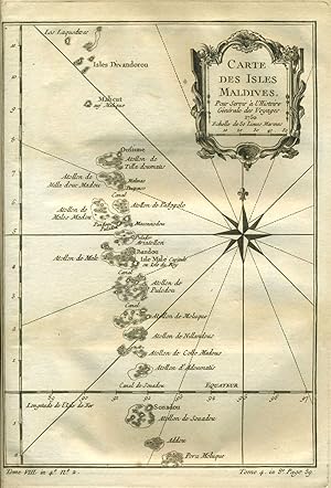
Published by Paris 1775
Seller: Antipodean Books, Maps & Prints, ABAA, Garrison, NY, U.S.A.Antipodean Books, Maps & Prints, ABAA
Contact seller3-star sellerCondition: Used - Very good
US$ 105.00
US$ 10.00 shippingShips within U.S.A.Quantity: 1 available
Condition: Very good condition. Detailed copper engraved map of the Maldives, southwest of India and Sri Lanka, and extending from Isles Divandorou down to Pora Moluque. The low elevation above sea level makes these islands the Earth's lowest nation, with concerns about rising sea levels causing its government to make a carbon n…eutral pledge. From Prevost's "L'Histoire Generale des Voyages". Bellin (1703 - 1772), one of the most noted French mapmakers of the 18th century, was named the hydrographer (chief cartographer) to the French Navy, and later, the Official Hydrographer to the French King. With a compass rose, rhumb lines and decorative cartouche. Strong impression, very clean.
- Art Print
Seller: Antiquariat Martin Barbian & Grund GbR, Saarbruecken, , GermanyAntiquariat Martin Barbian & Grund GbR
Contact seller5-star sellerCondition: Used
US$ 35.85
US$ 52.22 shippingShips from Germany to U.S.A.Quantity: 1 available
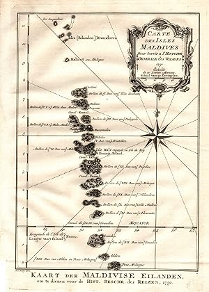
Kupferstich, 1750, 22x15 cm (Faltspuren) (Landkarten / Antique Maps / Indischer Ozean / Asien) *Schöner kräftige Abzug.

Kolumadulu Atoll Maldive Islands, Indian Ocean.
1954 U.S. Air Force Aeronautical Map of the Kolhumadulu Atoll, Maldives
- Map
Seller: Geographicus Rare Antique Maps, Brooklyn, NY, U.S.A.Geographicus Rare Antique Maps
Contact seller4-star sellerVery good. Minor wear and toning along original fold lines. Minor spotting. Size 22 x 29 Inches. This is a fine 1954 U.S. Air Force aeronautical chart or map of the Kolumadulu Atoll and vicinity of the Maldives located in the Indian Ocean. Focusing on Kolumadulu or Thaa Atoll, the map covers the Suvadiva Atoll, Haddummati Atoll,… Nilandu Atoll, Mulaku Atoll, Felidu Atoll, South Male Atoll, Ari Atoll and port of the Male Atoll. The Island of Male, where the capital of the Maldives is located is identified. The map is highly detailed and notes hydrographical and topographical features essential for the air pilot. Verso of this chart features legends and a world aeronautical chart index. This chart was published by the USAF Aeronautical Chart and Information Service, and was issued as chart no. 916. First issued in 1946, this is the third edition revised to Jan 1954.

Male Atoll Maldive Islands, Indian Ocean.
1958 U.S. Air Force Aeronautical Map of Male Atoll and Vicinity, Maldives
- Map
Seller: Geographicus Rare Antique Maps, Brooklyn, NY, U.S.A.Geographicus Rare Antique Maps
Contact seller4-star sellerVery good. Minor wear and toning along original fold lines. Minor spotting. Size 22 x 29 Inches. This is a fine 1958 U.S. Air Force aeronautical chart or map of the Male Atoll and vicinity of the Maldives located in the Indian Ocean. Focusing on Male Atoll, the map covers the Ihavandiffulu Atoll, the Tiladummati Atoll, the Milad…ummadulu Atoll, the North Malosmadulu and the South Malosmadulu Atoll, the Horsburgh Atoll, the Ari Atoll and part of the South Male Atoll. The Island of Male, where the capital of the Maldives is located is identified. The map is highly detailed and notes hydrographical and topographical features essential for the air pilot. Verso of this chart features legends and a world aeronautical chart index. This chart was published by the USAF Aeronautical Chart and Information Service, and was issued as chart no. 804. First issued in 1946, this is the second edition revised to May 1958.

- Map
Seller: Geographicus Rare Antique Maps, Brooklyn, NY, U.S.A.Geographicus Rare Antique Maps
Contact seller4-star sellerVery good condition. Original centerfold exhibits minor toning. Blank on verso. Size 11.75 x 16.5 Inches. A beautiful example of Rigobert Bonne's 1770 decorative map of southern India. Covers both the Malabar and Coromandel coasts as well as the Maldives, Ceylon (Sri Lanka), the Andaman Islands, and parts of Sumatra and Southeas…t Asia. Rhumb lines throughout. Arrows in the Indian Ocean show the direction of prevailing winds during the dry season and the monsoon season. This important Indian Ocean wind system, which blew one way for half the year, and the opposite for the other half, created a critical trade artery from antiquity to pre-modern times. Drawn by R. Bonne in 1770 for issue as plate no. B 26 in Jean Lattre's 1776 issue of the Atlas Moderne . References: Rumsey 2612.054. Phillips (Atlases) 664. National Maritime Museum, 215.

Avvertimento Al Navigli Che Partono Da Goa Per Andare Al Capo Di Buona Speranza Per Il Di Fuori Di Madagascar.
1696 Coronelli Globe Gore: Gulf of Hormuz, Indian Ocean, India, and the Maldives
- Map
Seller: Geographicus Rare Antique Maps, Brooklyn, NY, U.S.A.Geographicus Rare Antique Maps
Contact seller4-star sellerExcellent. Few marginal spots well away from printed image, else fine. Size 15 x 11.5 Inches. This is Vincenzo Coronelli's 1688 / 1696 globe gore, presenting a map of western India, coastal Persia, and the eastern extreme of the Arabian Peninsula. It was initially engraved in 1688 for Coronelli's 42-inch (3 1/2 foot) terrestrial… globe but was repurposed for publication in Coronlli's 1696 Libro dei Globi and Isolario . A Closer Look The gore spans from the Equator to about 25 degrees north. The map's northwest limits include the Kerman province of what is now Iran; the northeast shows part of Rajasthan in India. In the extreme southeast, a glimpse of Sri Lanka can be seen. The map includes the Maldives and an archipelago corresponding to the Lakshadweep Islands. The map thus presents the western coast of India, as well as the coasts of present-day Iran and Pakistan. Sources The text in the map's elegant cartouche credits the cartography to the reports of the Portuguese Aleixo da Mota (fl. 1595 - 1622). For the coastlines, this is credible: he was a pilot in India at the beginning of the 17th century and produced a manuscript of his travels in 1621. Its appearance here is significant, as da Mota's routier was not published until 1696, not only long after the author's death but well after the publication of Coronelli's globe. The interior portions are derived mainly from Jansson's 1636 map of the Mogul Empire. The coast near Mumbai shows other influences. Bombay is named ( Bombaim , after the Portuguese) within an exaggerated bay whose islands suggest Coronelli's familiarity with either the 1672 Fryer or the 1685 Thornton maps of Bombay. Publication History and Census This engraving was executed in 1688 as part of Coronelli's 3 1/2-foot terrestrial globe and was partially masked for inclusion in one of Coronelli's bound volumes. This sheet can be found in both the Libro Dei Globi and the Isolario . Scianna has cataloged only thirteen copies of the full Libro dei Globi in institutional and private collections; perhaps a dozen examples of the Isolario are cataloged in institutional collections. We see only two examples of the separate gore in OCLC: one at Yale and the other at the Qatar National Library. References: OCLC 166322485. Rumsey 11391.104. Wallis, H. 'Coronelli's Libro dei Globi' Der Globusfreund (International Coronelli Society, 1970), Scianna, N. 'New Findings on Vincenzo Coonelli's Birth and his 'Libro dei Globi''. Globe Studies (International Coronelli Society, 2009) Schmidt, R., and Bridge, R., 'Vincenzo Coronelli's Methods of Work. A Supplement to the Article in Der Globusfreund.' Globe Studies (International Coronelli Society, 2014).


