Manchukuo (10 results)
 More images
Published by Kokusho Publishing Association, 1976
- Softcover
Seller: Sunny Day Bookstore, SINGAPORE, SingaporeSunny Day Bookstore
Contact seller4-star sellerCondition: Used - Fine
US$ 175.00
US$ 15.00 shippingShips from Singapore to U.S.A.Quantity: 1 available
Add to basketCondition: Fine. The book is in fine condition.
 More images
Manchukuo Historic Sites Antiquities Survey Report 4: Historic Sites in Jilin and Binjiang Provinces
Published by Kokusho Publishing Association, 1976
- Softcover
Seller: Sunny Day Bookstore, SINGAPORE, SingaporeSunny Day Bookstore
Contact seller4-star sellerCondition: Used - Fine
US$ 175.00
US$ 15.00 shippingShips from Singapore to U.S.A.Quantity: 1 available
Add to basketCondition: Fine. The book is in fine condition.
 More images
Published by National Book Publishing Association, 1976
- Softcover
Seller: Sunny Day Bookstore, SINGAPORE, SingaporeSunny Day Bookstore
Contact seller4-star sellerCondition: Used - Fine
US$ 260.00
US$ 15.00 shippingShips from Singapore to U.S.A.Quantity: 1 available
Add to basketCondition: Fine. The book is in fine condition.

Published by , Published by the Land Survey Department, Japan, 1935, 1935
Seller: Librairie Xavier Dufaÿ, LA COLLE SUR LOUP, FranceLibrairie Xavier Dufaÿ
Contact seller3-star sellerCondition: Used
US$ 235.40
US$ 43.42 shippingShips from France to U.S.A.Quantity: 1 available
Add to basket77 x 109 cm, sur papier, pliures, un très petit trou à une pliure (3 x 5 mm environ). Loose leaf. Carte en couleurs au 1/2.500.000. Excellent état ; très rare.
Published by Department of Foreign Affairs, Manchoukuo Government,, Hsinking, Manchuria, China:, 1933
- First Edition
Seller: Zephyr Used & Rare Books, Vancouver, WA, U.S.A.Zephyr Used & Rare Books
Contact seller5-star sellerFour works in one. Tall 8vo. 22; [4], 46; [4], 35, [1]; [6], 36 pp., including all four parts with original green-tinted self-printed softcovers bound within. Printed beige-coloured softcovers (minor chipping head & foot of spine, some creasing, dustsoiling), still VG- copy, from library of Tom Atiyeh. First edition, thus, of th…is combined edition detailing the Imperialist Japanese government's justification, and role in revival of the Qing Dynasty under Emperor Pu-Yi with Zheng Xiaoxu as Prime Minister in March, 1934. This rump state in China's Manchurian region would be controlled and run by the Japanese until the end of World War II when Soviet forces defeated the Kwantung Army and captured Emperor Pu-yi.
Wang tao (The Kingly Way): an outline of the political-moral code of the Manchoukuo government.
[CHINA -- JAPANESE MANCHUKUO]. HSIAO-HSU,Premier Cheng. [ZHENG XIAOXU].
Published by The Manchuria Daily News, [1934]., [Dairen (Dalian) , Manchukuo, China]:, 1934
- First Edition
Seller: Zephyr Used & Rare Books, Vancouver, WA, U.S.A.Zephyr Used & Rare Books
Contact seller5-star seller8vo. [4], 41, [1] pp. Photo plate. Beige-coloured textured softcovers, black lettering front cover (minor corner creasing), still a VG bright copy, from the library of Tom Atiyeh. First offprint edition, of this very scarce work outlining the governing philosophy, and justifying principles outlined by Manchu loyalist, advisor to… former Hsuan-tung Emperor Pu-yi, and politician who believed that by aligning with the Japanese Empire, the Qing Dynasty could be restored in Manchuria, and combat China's rampant warlords. Following 1924 when Feng Yu-hsiang had occupied Peking, deposed the rump Emperor, and forced Pu-Yi and Zheng Xiaoxu (1860-1938) he had dedicated himself to restoring the Xing Dynasty, and their rule. The state of Manchoukuo, a Japanese puppet state was established March 1, 1934 with Zheng Xiaoxiu serving as the first prime minister until 1935 when the Japanese forced the Emperor to remove him from the payroll, and he was succeeded by Zhang Jinghui.

- Map
Seller: Geographicus Rare Antique Maps, Brooklyn, NY, U.S.A.Geographicus Rare Antique Maps
Contact seller4-star sellerVery good. Some discoloration along central fold line and at top and bottom margins. Size 24.25 x 29.25 Inches. This is a map of central Manchuria (portions of Heilongjiang and Jilin Provinces) from the 1933 edition of The Postal Atlas of China (??????), compiled by Charles Jacot-Guillarmod. It highlights the evolving postal inf…rastructure of the region, which had been contested between China, Japan, and Russia for decades and had become a de facto Japanese colony with the establishment of the puppet state of Manchukuo the previous year. Manchuria - Nexus of Northeast Asia This map was made at a time of great upheaval (described below) for the lands illustrated here. As the atlas was published by a wing of the Chinese government, Japanese imperial gains in northeastern China are not recognized, nor are the changes in placenames that followed, such as the renaming of Changchun to Xinjing (??, 'new capital'). In fact, the map's title uses the somewhat anachronistic title 'Three Eastern Provinces' (???), a Qing-era administration that had been expanded with the addition of a fourth province, Rehe (???, often Jehol in foreign sources), in 1928. Some sense of the openness of the region is given here, even after decades of migration from other parts of China. Infrastructure is minimal, and to the extent that it does exist it is oriented around major rivers and railways. Harbin (here as Pinkiang ??), in particular, sprang up in tandem with the railways and the city's culture and economy remained deeply tied to the railway network of Manchuria. Mantetsu, the Kwantung Army, and Manchuria The Treaty of Portsmouth that ended the Russo-Japanese War (1904 - 1905) granted to Japan, among other rights, the Kwantung Leased Territory and the southern section of the China Eastern Railway, from Changchun (??) to Port Arthur (?? Lüshun), which became known as the South Manchuria Railway (the northern section between Harbin and Changchun was jointly managed by Russia and China and came to be known as the North Manchuria Railway, ????). The company created to manage the southern section, the South Manchuria Railway Company (Mantetsu), soon developed into a mega-conglomerate that oversaw hotels, mines, mills, power plants, publishing, and much more, expanding Japanese influence in Manchuria to the point that it became a virtual colony. By the 1930s, Mantetsu was the largest company in Japan and by itself formed a significant portion of the Japanese economy. Although Japan already exercised an informal empire in much of Manchuria, the territory was still under the control of the Fengtian Clique of warlords, led by Zhang Zuolin. Meanwhile, a sizable Japanese garrison occupied the Kwantung Leased Territory, known as the Kwantung Army (or Kant?-gun in Japanese). The Kwantung Army was a hotbed of ultranationalism, militarism, and anti-democratic secret societies, and produced several of Japan's future wartime leaders, including T?j? Hideki. Although the Kwantung Army had initially supported Zhang Zuolin as a bulwark against Chiang Kai-Shek, who was seen as pro-Communist, he was assassinated soon after Chiang nominally reunified the country in 1928 when a bomb exploded under his private train traveling on the South Manchuria Railway. The plot had been hatched by junior officers in the Kwantung Army. Three years later, on September 18, 1931, a group of Kwantung Army officers staged a false flag incident (another bombing along the South Manchuria Railway) to provide a pretext for invading and occupying Manchuria. Although Japan's political leaders and likely even the military leadership were unaware of the invasion plot, they did not force the Kwantung Army to retreat despite international condemnation because the invasion was extremely popular domestically and was a convenient solution to Japan's long-term problems with resource constraints and overpopulation. The Birth of Manchukuo Rather than make Manchuria a formal colony, as with Taiwan, or annex it o.
 More images
Seller: Richard Neylon, St Marys, TAS, AustraliaRichard Neylon
Contact seller4-star sellerCondition: Used - Very good
US$ 539.05
US$ 31.00 shippingShips from Australia to U.S.A.Quantity: 1 available
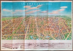
Add to basketCondition: very good. Shinkyo, Manshukoku Kokumuin Kokuto Kensetsukyoku 1936. Colour printed sheet 54x78cm with colour bird's eye view and panorama on one side; colour plan, smaller b/w photo illustrations and text on the other. Folded as issued, a small knick in a margin, minor signs of use. In many ways the new capital of Manc…hukuo was - is - a planner's dream. Here was an empire building militaristic government wanting to both experiment with all that had been learned about city planning and show the west that not only could they do it, but do it better. Changchun, a hybrid Chinese-Russian-Japanese railway town, was appointed the new capital, it was renamed, a five year plan for a new city was drawn up under the guidance of Professor Riki (or Toshikata) Sano in 1932, a quick compromise with a competing plan was made, and building was underway in early 1933. Local interests (ie the Chinese and Manchu population) and business were allowed notional input but the brief was clear: social theory, technology and architecture that made for an efficient colonial capital could be put into place, local self-interest could not. Of course it was not so simple. This was to be a pan-Asian showcase, superior to western, especially colonial western, models - not equal. Confucianism, traditional ritual and Asian racial harmony were to be a central part of the city. What more could any urbanist ask for? Students of the plan might like to start with Yishi Liu's 2011 doctoral thesis, 'Competing Visions of the Modern;' where Griffin's Canberra plan and Griffin's diagrams for road classification are illustrated beside Xinjing's. By 1936 - when our view of the future city was produced - a lot was still dust and open space but, by the gods, whatever else they learnt from Burley Griffin's Canberra - and it was a lot - about planning a city, they certainly learnt how not to build a city.What they already knew is what all architects know - by instinct? - to redraw plans to fit what has been built and what is likely to be built. This is, I think, the third or fourth of such views of the new city. There were similar prints in 1933, maybe in 34, and 35. The city was declared open in 1937. I'm yet to see the first but the changes between 1935 and 1936 are noteworthy. The plan is much the same, mildy shrunk, and some buildings in our imaginary bird's eye view may reflect actual building but what becomes clear is that ambition has been scaled back to come closer to what they thought could exist next year. City blocks of large scale housing are now more sparse clumps of bungalows; elaborate Sino-Japanese modernism is plain modernism.
 More images
- Map
Seller: Geographicus Rare Antique Maps, Brooklyn, NY, U.S.A.Geographicus Rare Antique Maps
Contact seller4-star sellerVery good. Original folds visible. Size 6.5 x 21 Inches. This is a c. 1938 bird's-eye view of the Japanese puppet state of Manchukuo in Manchuria. This document reflects growing sophistication of propaganda in support of Manchukuo, including English-language propaganda made purely for external consumption. Manchukuo from the Air… This view shows the enormous territory that fell under the control of the new puppet government established in 1932. Rail lines, arteries running through the vastness of Manchuria, are shown in black-and-white alternating lines (solid black when continuing into foreign territory) while major air routes are shown in red. Several other features are evident, including cities, industrial facilities, the Great Wall of China, and the former summer palace of the Qing Dynasty at Jehol (Rehe, Chengde). The main line of habitation, economic development, and political control followed the route of the South Manchuria Railway, from Harbin through Hsinking (Changchun), Mukden (Shenyang) and Dairen (Dalian). Verso and Cover Content The verso touts the progress made in Manchuria since the establishment of the puppet regime in 1932. The first two items on the list were the most common themes of propaganda supporting the new government: peace and economic development. As in many other spheres, Manchukuo was a testing ground for propaganda that would later be employed throughout East Asia. The themes of pan-Asian unity, peace, (re)construction, and Confucianism were the basis for Japan's wartime propaganda, formalized in the concept of the 'Greater East Asia Co-Prosperity Sphere.' The inside of the cover discusses in greater depth the concept of 'Wangtaoism' referred to on the verso. This vague ideology was rooted in an ancient Chinese concept of governance (the 'kingly way' ??) but added elements of inter-ethnic harmony meant to appeal to non-Han groups of the former Qing Empire, replaced in 1912 by the fractured Republic of China, dominated by the Han Chinese ethnicity. But the true purpose of this view is made clear by the bolded final paragraph on the back of the cover. Manchukuo had never gained international recognition and the state's creation was condemned by the League of Nations, leading eventually to Japan's withdrawal from that organization. The reference to Manchukuo's recognition by Italy, Spain, and Germany indicates that this undated view is from 1938 or later. Aside from these countries, only a handful of countries ever recognized Manchukuo, mostly likeminded military dictatorships and, after the start of World War II, fellow puppet regimes. That being said, foreign investors were more willing to work with the new regime than foreign governments, and it is likely that this propaganda was primarily intended for business travelers to Manchukuo, in the hope that they would return to their home country and exert political influence that would eventually lead to wider diplomatic recognition. Historical Background The Treaty of Portsmouth that ended the Russo-Japanese War (1904 - 1905) granted to Japan, among other rights, the southern section of the China Eastern Railway, from Changchun to Port Arthur (Lüshunkou, here as Ryojun), which became known as the South Manchuria Railway. The company created to manage the southern section, the South Manchuria Railway Company (?????????), soon developed into a mega-conglomerate, akin to the chartered corporations of early modern Europe. The company oversaw hotels, mines, mills, power plants, publishing, and much more, that expanded Japanese influence in Manchuria to the point that it became a virtual colony. By the 1930s, Mantetsu was the largest company in Japan and by itself formed a significant portion of the Japanese economy. Although Japan already exercised an informal empire in much of Manchuria, the territory was still under the control of a group of Chinese warlords known as the Fengtian Clique led by Zhang Zuolin (referred to here as the Chang regime, warlor.


