Manuscript Plan (12 results)
 More images
'Old Place'. Manuscript Plan of 'Old Place', Sleaford, Lincolnshire, 1858.
Manuscript Plan by Robt. C. Moore, Surveyor of Harmston, near Lincoln. 1858.
Published by [Sleaford, Lincolnshire, 1858.] 1858
- Hardcover
Seller: Offa's Dyke Books, LUDLOW, SALOP, United KingdomOffa's Dyke Books
Contact seller5-star sellerCondition: Used
US$ 539.30
US$ 33.56 shippingShips from United Kingdom to U.S.A.Quantity: 1 available
Coloured manuscript plan folding into wallet style binding to the scale of 3 chains to an inch, with a 10pp. manuscript bound in titled 'Reference', followed by blank leaves. Commencing 'In the Parish of Old Sleaford', 'In the Parish of New Sleaford', 'In the Parish of Kirkby-le-Thorpe', & 'In the Parish of Evedon' with a 'Summa…ry' of Income & Total; Description, Culture (e.g. grass), Fields, Planting & £ Totals, 9[1]pp. with blanks. Image sizes: Plan 603mm x369mm, Reference 147mm x 194mm. Plan folding into wallet style calf binding with fold over flap with double gilt rule to boards and gilt lettered to the front board 'Old Place', rubbed & lightly worn to extremeties, otherwise good & handsome with the plan bright & delicately coloured & the manuscript text neat & legible, very good condition. Sleaford is approx.18 miles from Lincoln, and Harmston 7 miles; situated on the edge of the Fenlands, it was the bronze age settlement of the Corieltauvi & has been inhabited ever since. The River Slea was an important navigable river & later canal before the railway had opened from Granthum to Sleaford in 1857. The gas works had opened in 1836 and it is now a commuter town with 18,000 inhabitants at 2011 census.
 More images
Published by Early Meiji?
Seller: Asia Bookroom ANZAAB/ILAB, Canberra, ACT, AustraliaAsia Bookroom ANZAAB/ILAB
Contact seller5-star sellerCondition: Used
US$ 400.28
US$ 21.25 shippingShips from Australia to U.S.A.Quantity: 1 available
Delightful colour pictorial folding manuscript plan, 28 x 39cm, folds into attractive pictorial card covers measuring 14 x 10cm, annotation on washi attached. Very good copy of a charming map. This delightful manuscript colour map of Gokokuji and its compound in Tokyo provides a detailed depiction of the temple, which was establ…ished in 1681 by the fourth Shogun, Tokugawa Tsunayoshi and can still be found in Tokyo today. The map highlights the main hall, where the Goddess of Mercy is enshrined, along with the surrounding halls and buildings within the temple complex. In the upper section and margin of the map, additional notes have been added in neat ink handwriting. Unfortunately, the content of these annotations remains undeciphered. This map not only offers a fascinating glimpse into the layout and architecture of Gokokuji but also serves as a valuable historical artefact, reflecting the temple's importance during the period in which the map was created.

Seller: Roger Collicott Books, Widecombe in the Moor, DEVON, United KingdomRoger Collicott Books
Contact seller5-star sellerCondition: Used - Good
US$ 186.68
US$ 42.49 shippingShips from United Kingdom to U.S.A.Quantity: 1 available
Manuscript. Condition: Good. Manuscript in ink with single outline wash colour, drawn on smooth linen and folded many times. Size 940 x 570 mm. Plots of land marked with names of the land owners, with additional manuscript notes drawn on the map, " Scale of this tracing 22 fathoms to one inch taken from the Tithe commutation map… with the numbers as thereon." " This proposed set of Wheal Jewell is bounded on the East by the parish of Perranuthnoe, on the West by the road called or known as Pedangwarry Lane, on the South by Trevenner Lane and the road from Marazion to Helstone, and on the North by the Parish of St Hilary excepting two fields which are not numbered but marked as A & B which said two fields are in the parish of Saint Hilary." I can find no mention of Wheal Jewell in Hamilton Jenkin. From the Justin Brooke Library.

Seller: Herman H. J. Lynge & Søn ILAB-ABF, Copenhagen, , DenmarkHerman H. J. Lynge & Søn ILAB-ABF
Contact seller4-star sellerCondition: Used
US$ 319.97
US$ 48.76 shippingShips from Denmark to U.S.A.Quantity: 1 available
(Belgien, ca. 1830). Papersize: 42 x 32 cm. Plan with text: 38,5 x 29,5 cm. A fine detailled plan of Charleroi surveyed by the Danish military officer C. Krag. Pen and ink with watercolour. Also with scale.
Seller: Herman H. J. Lynge & Søn ILAB-ABF, Copenhagen, , DenmarkHerman H. J. Lynge & Søn ILAB-ABF
Contact seller4-star sellerCondition: Used
US$ 399.96
US$ 48.76 shippingShips from Denmark to U.S.A.Quantity: 1 available
(Copenhagen, ca. 1820). Paper-size: 61 x 44 cm. Plan: 57 x 40,5 cm. Fine plan of "Festung Minden", pen and ink with watercolour. The author states (in Danish), that it is sketched after memory, but he has been on the spot.
Seller: Herman H. J. Lynge & Søn ILAB-ABF, Copenhagen, , DenmarkHerman H. J. Lynge & Søn ILAB-ABF
Contact seller4-star sellerCondition: Used
US$ 447.96
US$ 48.76 shippingShips from Denmark to U.S.A.Quantity: 1 available
Kjøbenhavn, November, 1862. Large manuscript plate of the fortification, paper-size 61 x 81 cm. and handcoloured. Drawn by Wüstenberg, Sergeant, Copenhagen, 1862. Also with a transverse section and scale.
Seller: Herman H. J. Lynge & Søn ILAB-ABF, Copenhagen, , DenmarkHerman H. J. Lynge & Søn ILAB-ABF
Contact seller4-star sellerCondition: Used
US$ 559.95
US$ 48.76 shippingShips from Denmark to U.S.A.Quantity: 1 available
(Liege, around 1830). Paper size: 71 x 80 cm. - Plan: 47 x 69 cm. Probably surveyed by the Danish military officer C. Krag. Pen and ink with watercolour. Also with scale. A manuscript glazine paper - can be lifted - attached to part of image giving more indformation of the environment and with its own scale. 2 small closed tears… at ends of folding, not affecting image.

- Map
Seller: Geographicus Rare Antique Maps, Brooklyn, NY, U.S.A.Geographicus Rare Antique Maps
Contact seller4-star sellerExcellent. Size 15.375 x 20.625 Inches. This is August Szontagh's remarkable 1842 manuscript map of Stockholm, Sweden. The map captures Stockholm during a period of expansion and civic infrastructure reform. Though likely academic rather than administrative, this plan exhibits the meticulous style we've come to associate with mi…litary engineering draftsmanship. A Closer Look This intricately detailed and expertly drawn manuscript map is so well done that it appears at first glance to be a copperplate print. It is even more noteworthy for being a purely sui generis work rather than a hand copy of an existing map. The map covers from the modern districts of Norrmalm, Vasastan, and Östermalm, famous for their parks and late 19th-century architecture, southwards to the Årstaviken and Hammarby Sjö, westward to include the entire island of Kungsholmen, and eastward to include the islands of Djurgården. The elevation is indicated by hachure, with terrain shaded to indicate nature and use (buildings, farms, forests, gardens, etc.). Streets and city blocks are neatly traced, while country roads, paths, and bridges are similarly marked out. Several features throughout the map are labeled, mostly islands, islets, and waterways. Several buildings are easily recognizable from their location and shape, such as the Royal Palace (Kungliga Slottet) and the historic Kastellet Stockholm. Historical Context Although Sweden had been one of the great European powers of the 17th and early 18th centuries, it was heavily impacted by its loss in the Great Northern War (1700 - 1721), being supplanted by Russia and, to a lesser extent, Prussia as the major powers in northern Europe. In one respect, the war had a beneficial impact in that it temporarily empowered the parliament vis-à-vis the monarchy, leading to the era after the Great Northern War being dubbed the Age of Liberty. However, economically and demographically, Sweden was falling far behind; some early industrial ventures were launched, but the economy remained overwhelmingly agricultural. Influenced by developments elsewhere in Europe, Sweden shifted towards absolute monarchy under Gustav III (r. 1771 - 1792) but was incapable of fending off a French invasion, a coup d'état, and the loss of Finland to Russia in the course of the Napoleonic Wars (1803 - 1815). Not long after this map's publication, however, both Stockholm and Sweden underwent significant changes. Stockholm, in particular, embraced industrialization with railroads, factories, and modern infrastructure, as well as a comprehensive city plan in 1866, inspired by the same ideas that drove Haussmann's renovation of Paris. Large portions of the city, especially the Klara district in Norrmalm, were radically transformed, and by the end of the 19th century, they would hardly resemble the city seen here. Publication History and Census This map was drawn by one August Szontagh and is dated 1842. Szontagh's identity is a mystery; he presumably was a German-speaker as that is the language of the map, and he gives himself the title 'burgakademiker,' which suggests an official scholarly position. But we have been unable to identify any historical sources with a person by this name and title, though an 1875 issue of the weekly publication Fremden-Blatt issued in Vienna refers to 'Oberst August Szontagh' attending an anniversary celebration for an infantry regiment stationed in Lemberg (Lviv). In this case, perhaps Szontagh was an Austrian infantry officer who had prepared this map during a sojourn in Stockholm. In any event, the map does not closely resemble any of the major contemporaneous printed maps of the city, taking in a wider perspective than usual that includes the city's hinterland (for comparison, see the more than 100 maps listed in the category page in the Wikimedia Commons titled '19th-century maps of Stockholm'). The lack of a stated scale, the idiosyncratic appearance of some of the city's islands and features, and the a.

Office of the President of the Borough of Brooklyn Bureau of Highways and Sewers Division of Street Plan Records Map of the Borough of Brooklyn City of New York 1939.
1939 Borough of Brooklyn City Map or Plan of Brooklyn w/ Manuscript Railroads
- Map
Seller: Geographicus Rare Antique Maps, Brooklyn, NY, U.S.A.Geographicus Rare Antique Maps
Contact seller4-star sellerVery good. Dissected and mounted on linen in 35 panels. Size 39.75 x 31 Inches. This is a 1939 Bureau of Highways and Sewers city map or plan of Brooklyn, New York featuring manuscript notations highlighting railroad lines in the borough. The map depicts the region from The Narrows and Staten Island (labeled as Borough of Richmo…nd) to Jamaica Bay and from Long Island City to the Atlantic Ocean. Myriad streets throughout Brooklyn are illustrated and labeled, along with the borough's many parks. Both Prospect Park and Greenwood Cemetery are illustrated in detail. Floyd Bennet Field, an airfield near Jamaica Bay, is also labeled. Some detail is present along the East River in Manhattan, including the Brooklyn Bridge, Manhattan Bridge, and Williamsburg Bridge spanning the river between Manhattan and Brooklyn. Manuscript Railroad Lines Several rail lines throughout Brooklyn are highlighted here in manuscript with different colors used to differentiate between the lines and a key is situated in the lower left corner. The orange lines indicate routes and yards owned by the Long Island Railroad (L.I.R.R.), including the Montauk Branch (from Long Island City and Bushwick and originally known as the South Side Railroad of Long Island) and the Bay Ridge Branch (originally opened as the New York, Bay Ridge and Jamaica Railroad in 1876). Today, only freight trains operate along the Bay Ridge Branch. The South Brooklyn Railway, which was founded in 1887, is marked here in purple. This railway operated under several different names and owners until it was acquired by the Brooklyn-Manhattan Transit Corporation in in the mid-1920s. Operation was transferred to the city on June 1, 1940, but use continued to decline throughout the second half of the 20th century. Today, the South Brooklyn Railway runs freight operations from the 36th-38th Street Yard, but most of the traffic is subway connections to the L.I.R.R. Bay Ridge Branch. Two specific rail networks, those used at the Bush Terminal and at the New York Docks are marked as well. Publication History and Census This map is most likely one of a kind. The base map was created and published by the Division of Street Plan Records of the Bureau of Highways and Sewers of the Office of the President of the Borough of Brooklyn in 1939, and we have been unable to locate any other known examples. That said, this example was repurposed by the Pennsylvania Railroad to illustrate railroad routes and ferries, making it a unique find.
Seller: Herman H. J. Lynge & Søn ILAB-ABF, Copenhagen, , DenmarkHerman H. J. Lynge & Søn ILAB-ABF
Contact seller4-star sellerCondition: Used
US$ 719.93
Free ShippingShips from Denmark to U.S.A.Quantity: 1 available
Frankfurt 2. Martz 1829. 64 x 121 cm. Large plan of the fortress at Hartenberg surveyed by the Danish military officer C. Krag. Pen and ink with watercolour. Also with scale and profiles at bottom and a small map showing the environsment. On 2 sheets joined.
1. Plan Kreuz Schanze. 2. Kreuzschanze. Details.
FESTUNG KREUZSCHANZE (MAINZ ?) - MANUSCRIPT PLAN AND DETAILS. 2 SHEETS.
- Signed
Seller: Herman H. J. Lynge & Søn ILAB-ABF, Copenhagen, , DenmarkHerman H. J. Lynge & Søn ILAB-ABF
Contact seller4-star sellerCondition: Used
US$ 719.93
Free ShippingShips from Denmark to U.S.A.Quantity: 1 available
Frankfurt a. Main, August 9 and August 20, 1829. 1. Plan: 63 x 81 cm. - 2. Details with 8 large illustrations, profiles, elevations etc.: 63,5 x 96,5 cm. With 2 smaller closed tears (no loss). Surveyed and signed by C. Krag, a Danish military officer. Pen and ink with watercolour.
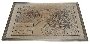
Grund Tegning af Fästningen og Castellet Neÿstad. (Plan of the Fortification and the Citadel in Neustadt).
FESTUNG NEUSTADT (NEUSTADT AM RÜBENBERGE) - MANUSCRIPT PLAN.
Seller: Herman H. J. Lynge & Søn ILAB-ABF, Copenhagen, , DenmarkHerman H. J. Lynge & Søn ILAB-ABF
Contact seller4-star sellerCondition: Used
US$ 767.93
Free ShippingShips from Denmark to U.S.A.Quantity: 1 available
Around 1800. 26,5x43 cm. (Paper size 32x48,5 cm.). Detailled manuscript plan on the fortifications and surroundings of Neustadt. Ink and handcoloured. Upper right corner of paper gone but not affecting image. Light browning and marginal brownspots. Framed and under glass.


