
Order Total (1 Item Items):
Shipping Destination:

Map Burke Howard (3 results)
Skip to main search results
Search filters
Product Type
- All Product Types
- Books (3)
- Magazines & Periodicals (No further results match this refinement)
- Comics (No further results match this refinement)
- Sheet Music (No further results match this refinement)
- Art, Prints & Posters (No further results match this refinement)
- Photographs (No further results match this refinement)
- Maps (No further results match this refinement)
- Manuscripts & Paper Collectibles (No further results match this refinement)
Condition Learn more
- New (No further results match this refinement)
- As New, Fine or Near Fine (No further results match this refinement)
- Very Good or Good (No further results match this refinement)
- Fair or Poor (No further results match this refinement)
- As Described (3)
Binding
- All Bindings
- Hardcover (No further results match this refinement)
- Softcover (No further results match this refinement)
Collectible Attributes
- First Edition (No further results match this refinement)
- Signed (No further results match this refinement)
- Dust Jacket (No further results match this refinement)
- Seller-Supplied Images (3)
- Not Print on Demand (3)
Language (1)
Price
- Any Price
- Under US$ 25 (No further results match this refinement)
- US$ 25 to US$ 50 (No further results match this refinement)
- Over US$ 50
Free Shipping
- Free Shipping to U.S.A. (No further results match this refinement)
Seller Location
Seller Rating
-

American Roads to Peace
Published by Los Angeles Examiner. Sunday 1 May1938., Los Angeles., 1938
Seller: Asia Bookroom ANZAAB/ILAB, Canberra, ACT, Australia
Association Member: ANZAAB ILAB
Seller rating 5 out of 5 stars

Printed colour pictorial map 33 x 48 cms; 41.8 x 54.5 cms (sheet) central fold, sheet toned, corners chipped with some loss to the bottom border and at the central fold, in good condition; and on the verso "Movie-Go-Round" by Louella O. Parsons, black and white photos and advertisements. Pictorial map printed for the weekend supplement of the Randolph Hearst owned newspaper the Los Angeles Examiner. The map-maker and artist Howard Burke had also worked for the San Francisco Examiner and was known for pictorial maps, many with a persuasive or rhetorical edge, and as here, were designed to shore up American patriotism and defences against a wider world in the increasingly turbulent pre-war 1930s. The caption to this map outlines a multi-billion dollar 25 year proposal by Congressman J. Buell Snyder for a network of coast to coast transcontinental highways "in case of an attack by a foreign power at any point along the border". Buell Snyder earned the soubriquet "the father of superhighways" and during the War he was assigned to a Congressional Committee in charge of appropriations for the War Department. Scarce.
-
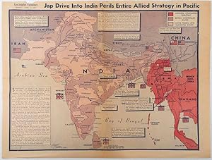
Jap Drive into India perils entire Allied strategy in Pacific
Published by Los Angeles Examiner. April 31944., Los Angeles.
Seller: Asia Bookroom ANZAAB/ILAB, Canberra, ACT, Australia
Association Member: ANZAAB ILAB
Seller rating 5 out of 5 stars
Colour pictorial map on a single newspaper leaf 37 x 50 cms; 41.5 x 54.6 cms (sheet), unrelated text on the verso (although with an interesting account from a soldier's letter about an air raid in China), toning, more marked at the central fold (two small splits, no loss to the map), edge wear with several small marginal edge tears neatly repaired on the verso with archival washi (map unaffected), in good condition. A dynamic map prepared and illustrated by the Examiner's art critic and editor Howard Burke, covering the area surrounding India and Central Asia showing Japanese conquered territory in Malaya, Thailand, Indo-China and Burma; and in India British-controlled states and native feudal and protected states. Text boxes and pictographs give an overview of the geopolitical situation, from the Allied perspective. One box notes "Chanda Bose has many adherents and fanatical followers in Bengal. They may prove to be a powerful fifth column in India". Text at lower edge opines "The situation in India is critical and has grown more so as the all-out offensive against Japan has been delayed. If the Allies do not act at once, and with great force, all our gains may be wiped out and the war in the Pacific prolonged indefinitely." The decisive and devastating bombings that were to signal such an end were four months away. Rare on the market.
-
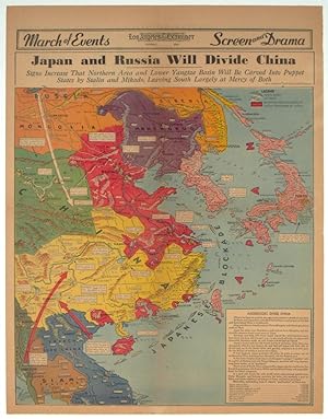
Japan and Russia Will Divide China. Signs Increase That Northern Area and Lower Yangtze Basin Will be Carved Into Puppet States by Stalin and Mikado, Leaving South Largely at Mercy of Both.
Published by Los Angeles Examiner., Los Angeles., 1940
Seller: Asia Bookroom ANZAAB/ILAB, Canberra, ACT, Australia
Association Member: ANZAAB ILAB
Seller rating 5 out of 5 stars
Printed colour pictorial map on a single newspaper leaf, 42.3 x 39.9 cms; 54.3 x 42.5 cms (sheet), archivally laid down on linen, slight discoloration to lower centrefold and sheet slightly age-toned, but in very good condition. A striking geopolitical map by Los Angeles Examiner artist Howard Burke covering China, Japan, Southern Russia and the northern part of French Indochina and Siam, showing how the "Aggressors Divide China." Areas under Japanese occupation are shown in red, and their naval blockade shown by an arc of naval vessels, with vivid arrows indicating lines of supply. Text labels (including sources of agricultural and raw materials) provide a dynamic overview of the geopolitical situation, and show the influence of American scientific illustrator and cartographer Richard Edes Harrison who argued for examining geographic issues from multiple perspectives , and Los Angeles Times artist Charles Owens.