Map Colton (114 results)

Published by Johnson & Browning, Richmond, VA 1861
- Softcover
- First Edition
- Art Print
Seller: Dorley House Books, Inc., Hagerstown, MD, U.S.A.Dorley House Books, Inc.
Contact seller4-star sellerCondition: Used - Very good
US$ 55.00
US$ 8.65 shippingShips within U.S.A.Quantity: 1 available
Unbound. Condition: Very Good. 1st. Plate #50; lovely hand-colored map; of Iowa & Nebraska at the beginning of the Civil War, decorative strapwork border; w/ Counties, cities, roads, rivers, railroads, wagon roads,canals, ports, etc & w/ insect engraving; some insect damage at border as shown Size: 17" x 13.5". Handcolored Map (…illustrator).

Published by Colton, New York 1855
- Hardcover
Seller: Borg Antiquarian, Lake Forest, IL, U.S.A.Borg Antiquarian
Contact seller5-star sellerCondition: Used - Good
US$ 65.00
US$ 6.95 shippingShips within U.S.A.Quantity: 1 available
Condition: Good +. Folio's overall measurements c.14 1/2" W x 16 3/4" H; printed area measures c.13 1/2" x 14 1/4" H. Attractive and detailed, hand-colored, lithographed map of the globe's Western hemisphere. Very frameable with minor defects mainly confined to the margins. Slight toning and spotting to margins & a few short spl…its to edges (mended with archival tape).

Published by Johnson & Browning, Richmond, VA 1861
- Softcover
- First Edition
Seller: Dorley House Books, Inc., Hagerstown, MD, U.S.A.Dorley House Books, Inc.
Contact seller4-star sellerCondition: Used - Very good
US$ 75.00
US$ 8.65 shippingShips within U.S.A.Quantity: 1 available
Unbound. Condition: Very Good. 1st. Plate #8: lovely diagram, Washington, D.C. at the center with figures positioned on the dial denoting air line distances from the nation's Capital Size: 17 x 13 Inches. Hand Colored Map (illustrator).

MAP: "Johnson's Map of Maine (1861)'.from Johnson's New Illustrated (Steel Plate) Family Atlas, 1861
Published by Johnson & Browning, Richmond, VA 1861
- Softcover
- First Edition
- Art Print
Seller: Dorley House Books, Inc., Hagerstown, MD, U.S.A.Dorley House Books, Inc.
Contact seller4-star sellerCondition: Used - Very good
US$ 85.00
US$ 8.65 shippingShips within U.S.A.Quantity: 1 available
Unbound. Condition: Very Good. 1st. Plate #22: lovely full page hand-colored map; mid-19th century, decorative strapwork style border. of the state of Maine,w/ railroads, canals, common roads, cities, towns, and villages in the mid-19th century. S Size: 17 x 13 Inches. Handcolored Map (illustrator).

Published by New York: Published by J. H. Colton., 1855. 1855
- Map
Seller: Spike Hughes Rare Books ABA, Innerleithen, , United KingdomSpike Hughes Rare Books ABA
Contact seller5-star sellerCondition: Used
US$ 41.45
US$ 34.88 shippingShips from United Kingdom to U.S.A.Quantity: 1 available
Litho. map, overall size 475 X 400 mm., hand-coloured, decorative border. With 'No. 5' in top right hand blank margin.

Published by Johnson & Browning, Richmond, VA 1861
- Softcover
- First Edition
- Art Print
Seller: Dorley House Books, Inc., Hagerstown, MD, U.S.A.Dorley House Books, Inc.
Contact seller4-star sellerCondition: Used - Very good
US$ 135.00
US$ 8.65 shippingShips within U.S.A.Quantity: 1 available
Unbound. Condition: Very Good. 1st. Plate #23, 24: lovely double page hand-colored map; mid-19th century, decorative strapwGreen Mountains indicated, , railroads and canals as well. Lower right quadrant goes beyond the bordering as shown. Size: 17 x 24.5 Inches. Handcolored Map (illustrator).

Published by Johnson & Browning, Richmond, VA 1861
- Softcover
- First Edition
- Art Print
Seller: Dorley House Books, Inc., Hagerstown, MD, U.S.A.Dorley House Books, Inc.
Contact seller4-star sellerCondition: Used - Very good
US$ 150.00
US$ 8.65 shippingShips within U.S.A.Quantity: 1 available
Unbound. Condition: Very Good. 1st. Plate #82; lovely hand-colored map; of ASIA at the beginning of the US Civil War, decorative strapwork border; w/ Counties, cities, roads, rivers, railroads, wagon roads,canals, ports, etc Size: 17" x 13.5". Handcolored Map (illustrator).

Published by Johnson & Browning, Richmond, VA 1861
- Softcover
- First Edition
- Art Print
Seller: Dorley House Books, Inc., Hagerstown, MD, U.S.A.Dorley House Books, Inc.
Contact seller4-star sellerCondition: Used - Very good
US$ 150.00
US$ 8.65 shippingShips within U.S.A.Quantity: 1 available
Unbound. Condition: Very Good. 1st. Plate #4,5: lovely double page map (lite toning) ; hemispheric projections of the world in the mid 19th century Size: 17 x 24.5 Inches. Handcolored Map (illustrator).
Published by Johnson & Browning, Richmond, VA 1861
- Softcover
- First Edition
- Art Print
Seller: Dorley House Books, Inc., Hagerstown, MD, U.S.A.Dorley House Books, Inc.
Contact seller4-star sellerCondition: Used - Very good
US$ 165.00
US$ 8.65 shippingShips within U.S.A.Quantity: 1 available
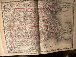
Unbound. Condition: Very Good. 1st. Plate #25,26: lovely double page hand-colored map; of three states as well as Long Island Soumd ports, the Massachusetts Islands Cape Cod, etc . as in mid-19th century, decorative strapwork border; and indicated counties, townships, railroads, towns, roads, railroads, etc. small marginal repai…r at lower edge Size: 17 x 24.5 Inches. Handcolored Map (illustrator).
Published by G.W. & C.B. Colton & Co., (Successors of J.H. Colton),, New York: 1875
- Hardcover
Seller: Zephyr Used & Rare Books, Vancouver, WA, U.S.A.Zephyr Used & Rare Books
Contact seller5-star seller16mo. 3.5 x 5 in. With hand-coloured 3 colour map which folds out into 14 x 16.5 in. map printed on thin onionskin paper, tipped-in to original embossed brown publisher's portfolio pocket binding, yellow printed front pastedown (minor toning, slight wear at creases), still NF fresh copy. Later edition of this 19th-century pocket… map showing New Hampshire's Counties, as well as the adjacent portions of Vermont & Maine showing roads and railroads leading into both. George Woolworth Colton (1827-1901), and brother Charles B. Colton (1832-1916) had reconstituted the firm following the Civil War, and riding the railroad building boom were active in continuing to update and issue pocket maps for eager travelers.

Published by Johnson & Browning, Richmond, VA 1861
- Softcover
- First Edition
- Art Print
Seller: Dorley House Books, Inc., Hagerstown, MD, U.S.A.Dorley House Books, Inc.
Contact seller4-star sellerCondition: Used - Very good
US$ 175.00
US$ 8.65 shippingShips within U.S.A.Quantity: 1 available
Unbound. Condition: Very Good. 1st. Plate #80, 81; lovely double page hand-colored map; of Austria, Turkey in Europe & Greece at the beginning of the US Civil War, decorative strapwork border; w/ Counties, cities, roads, rivers, railroads, wagon roads,canals, ports, etc. w/ inset of Candia and an engravig Size: 17" x 24.5". Hand…colored Map (illustrator).

Published by Johnson & Browning, Richmond, VA 1861
- Softcover
- First Edition
- Art Print
Seller: Dorley House Books, Inc., Hagerstown, MD, U.S.A.Dorley House Books, Inc.
Contact seller4-star sellerCondition: Used - Very good
US$ 175.00
US$ 8.65 shippingShips within U.S.A.Quantity: 1 available
Unbound. Condition: Very Good. 1st. Plate #85; lovely hand-colored map; of Hindostan or British India at the beginning of the US Civil War, decorative strapwork border; w/ Counties, cities, roads, rivers, railroads, wagon roads,canals, ports, etc. w/insets of Madras & Calcutta & Bombay and an engravig Size: 17" x 13.5". Handcolo…red Map (illustrator).

Published by Johnson & Browning, Richmond, VA 1861
- Softcover
- First Edition
- Art Print
Seller: Dorley House Books, Inc., Hagerstown, MD, U.S.A.Dorley House Books, Inc.
Contact seller4-star sellerCondition: Used - Very good
US$ 175.00
US$ 8.65 shippingShips within U.S.A.Quantity: 1 available
Unbound. Condition: Very Good. 1st. Plate #74; lovely hand-colored map; of Switzerland( at the beginning of the US Civil War, decorative strapwork border; w/ Counties, cities, roads, rivers, railroads, wagon roads,canals, ports, etc & with an inset od Hamburg & Bremen Size: 17" x 13.5". Handcolored Map (illustrator).

Published by Johnson & Browning, Richmond, VA 1861
- Softcover
- First Edition
- Art Print
Seller: Dorley House Books, Inc., Hagerstown, MD, U.S.A.Dorley House Books, Inc.
Contact seller4-star sellerCondition: Used - Very good
US$ 175.00
US$ 8.65 shippingShips within U.S.A.Quantity: 1 available
Unbound. Condition: Very Good. 1st. Plate #89, 90; lovely double page hand-colored map; of Africa at the beginning of the US Civil War, decorative strapwork border; w/ Counties, cities, roads, rivers, railroads, wagon roads,canals, ports, etc. w/ inset St. Helena and 2 engravings Size: 17" x 24.5". Handcolored Map (illustrator).

Published by Johnson & Browning, Richmond, VA 1861
- Softcover
- First Edition
- Art Print
Seller: Dorley House Books, Inc., Hagerstown, MD, U.S.A.Dorley House Books, Inc.
Contact seller4-star sellerCondition: Used - Very good
US$ 175.00
US$ 8.65 shippingShips within U.S.A.Quantity: 1 available
Unbound. Condition: Very Good. 1st. Plate #69, 70; lovely double page hand-colored map; of Holland & Belgium at the beginning of the US Civil War, decorative strapwork border; w/ Counties, cities, roads, rivers, railroads, wagon roads,canals, ports, etc & with an inset of Corsicca, Amsterdan & Brussels Size: 17" x 24.5". Handcol…ored Map (illustrator).

Published by Johnson & Browning, Richmond, VA 1861
- Softcover
- First Edition
- Art Print
Seller: Dorley House Books, Inc., Hagerstown, MD, U.S.A.Dorley House Books, Inc.
Contact seller4-star sellerCondition: Used - Very good
US$ 175.00
US$ 8.65 shippingShips within U.S.A.Quantity: 1 available
Unbound. Condition: Very Good. 1st. Plate #88; lovely hand-colored map; of AUSTRALIA at the beginning of the US Civil War, decorative strapwork border; w/ Counties, cities, roads, rivers, railroads, wagon roads,canals, ports, etc. w/insets of Yesso & Nagasaki Size: 17" x 13.5". Handcolored Map (illustrator).

Published by Johnson & Browning, Richmond, VA 1861
- Softcover
- First Edition
- Art Print
Seller: Dorley House Books, Inc., Hagerstown, MD, U.S.A.Dorley House Books, Inc.
Contact seller4-star sellerCondition: Used - Very good
US$ 175.00
US$ 8.65 shippingShips within U.S.A.Quantity: 1 available
Unbound. Condition: Very Good. 1st. Plate #65,66; lovely double page hand-colored map; of England & Wales at the beginning of the US Civil War, decorative strapwork border; w/ Counties, cities, roads, rivers, railroads, wagon roads,canals, ports, etc & with an inset of Scilly Isles Size: 17" x 24.5". Handcolored Map (illustrator…).
Published by Johnson & Browning, Richmond, VA 1861
- Softcover
- First Edition
- Art Print
Seller: Dorley House Books, Inc., Hagerstown, MD, U.S.A.Dorley House Books, Inc.
Contact seller4-star sellerCondition: Used - Very good
US$ 175.00
US$ 8.65 shippingShips within U.S.A.Quantity: 1 available
Unbound. Condition: Very Good. 1st. Plate #67, 68; lovely double page hand-colored map; of Ireland & Scotland at the beginning of the US Civil War, decorative strapwork border; w/ Counties, cities, roads, rivers, railroads, wagon roads,canals, ports, etc & with an inset of the Shetland Isles & the Orkney Isles Size: 17" x 24.5".… Handcolored Map (illustrator).

Published by Johnson & Browning, Richmond, VA 1861
- Softcover
- First Edition
- Art Print
Seller: Dorley House Books, Inc., Hagerstown, MD, U.S.A.Dorley House Books, Inc.
Contact seller4-star sellerCondition: Used - Very good
US$ 175.00
US$ 8.65 shippingShips within U.S.A.Quantity: 1 available
Unbound. Condition: Very Good. 1st. Plate #54,55; lovely double page hand-colored map; of SOUTH AMERICA at the beginning of the Civil War, decorative strapwork border; w/ Counties, cities, roads, rivers, railroads, wagon roads,canals, ports, etc & w/ inset engraving Size: 17" x 24.5". Handcolored Map (illustrator).

Published by Johnson & Browning, Richmond, VA 1861
- Softcover
- First Edition
- Art Print
Seller: Dorley House Books, Inc., Hagerstown, MD, U.S.A.Dorley House Books, Inc.
Contact seller4-star sellerCondition: Used - Very good
US$ 175.00
US$ 8.65 shippingShips within U.S.A.Quantity: 1 available
Unbound. Condition: Very Good. 1st. Plate #71; lovely hand-colored map; of Spain & Portugal at the beginning of the US Civil War, decorative strapwork border; w/ Counties, cities, roads, rivers, railroads, wagon roads,canals, ports, etc & with an inset o Gilbraltar Size: 17" x 13.5". Handcolored Map (illustrator).

Published by Johnson & Browning, Richmond, VA 1861
- Softcover
- First Edition
- Art Print
Seller: Dorley House Books, Inc., Hagerstown, MD, U.S.A.Dorley House Books, Inc.
Contact seller4-star sellerCondition: Used - Very good
US$ 175.00
US$ 8.65 shippingShips within U.S.A.Quantity: 1 available
Unbound. Condition: Very Good. 1st. Plate #775, 76; lovely double page hand-colored map; of Germany No. 2 & No. 3 at the beginning of the US Civil War, decorative strapwork border; w/ Counties, cities, roads, rivers, railroads, wagon roads,canals, ports, etc Size: 17" x 24.5". Handcolored Map (illustrator).

Published by Johnson & Browning, Richmond, VA 1861
- Softcover
- First Edition
- Art Print
Seller: Dorley House Books, Inc., Hagerstown, MD, U.S.A.Dorley House Books, Inc.
Contact seller4-star sellerCondition: Used - Very good
US$ 175.00
US$ 8.65 shippingShips within U.S.A.Quantity: 1 available
Unbound. Condition: Very Good. 1st. Plate #78, 79; lovely double page hand-colored map; of Northern & Southern ITALY at the beginning of the US Civil War, decorative strapwork border; w/ Counties, cities, roads, rivers, railroads, wagon roads,canals, ports, etc. w/ inset of Malta Size: 17" x 24.5". Handcolored Map (illustrator).

Published by Johnson & Browning, Richmond, VA 1861
- Softcover
- First Edition
- Art Print
Seller: Dorley House Books, Inc., Hagerstown, MD, U.S.A.Dorley House Books, Inc.
Contact seller4-star sellerCondition: Used - Very good
US$ 175.00
US$ 8.65 shippingShips within U.S.A.Quantity: 1 available
Unbound. Condition: Very Good. 1st. Plate #72, 73; lovely double page hand-colored map; of Prussia, Norway, Sweden & Denmark at the beginning of the US Civil War, decorative strapwork border; w/ Counties, cities, roads, rivers, railroads, wagon roads,canals, ports, etc & with 2 engravings Size: 17" x 24.5". Handcolored Map (illu…strator).

Published by Johnson & Browning, Richmond, VA 1861
- Softcover
- First Edition
- Art Print
Seller: Dorley House Books, Inc., Hagerstown, MD, U.S.A.Dorley House Books, Inc.
Contact seller4-star sellerCondition: Used - Very good
US$ 175.00
US$ 8.65 shippingShips within U.S.A.Quantity: 1 available
Unbound. Condition: Very Good. 1st. Plate #91, 92; lovely double page hand-colored map; of the Roman Empire . decorative strapwork border; w/ Counties, cities, roads, rivers, railroads, wagon roads,canals, ports, etc. w/ inset St. Helena and 2 engravings Size: 17" x 24.5". Handcolored Map (illustrator).

Published by Johnson & Browning, Richmond, VA 1861
- Softcover
- First Edition
- Art Print
Seller: Dorley House Books, Inc., Hagerstown, MD, U.S.A.Dorley House Books, Inc.
Contact seller4-star sellerCondition: Used - Very good
US$ 175.00
US$ 8.65 shippingShips within U.S.A.Quantity: 1 available
Unbound. Condition: Very Good. 1st. Plate #86; lovely hand-colored map; of JAPAN, Nippon, Kiusui, Siskok, Yesso and the Japanese Kuriles at the beginning of the US Civil War, decorative strapwork border; w/ Counties, cities, roads, rivers, railroads, wagon roads,canals, ports, etc. w/insets of Yesso & Nagasaki Size: 17" x 13.5".… Handcolored Map (illustrator).

Published by Johnson & Browning, Richmond, VA 1861
- Softcover
- First Edition
- Art Print
Seller: Dorley House Books, Inc., Hagerstown, MD, U.S.A.Dorley House Books, Inc.
Contact seller4-star sellerCondition: Used - Very good
US$ 175.00
US$ 8.65 shippingShips within U.S.A.Quantity: 1 available
Unbound. Condition: Very Good. 1st. Plate #63,64; lovely double page hand-colored map; of Europe at the beginning of the Civil War, decorative strapwork border; w/ Counties, cities, roads, rivers, railroads, wagon roads,canals, ports, etc & Size: 17" x 24.5". Handcolored Map (illustrator).

Published by Johnson & Browning, Richmond, VA 1861
- Softcover
- First Edition
- Art Print
Seller: Dorley House Books, Inc., Hagerstown, MD, U.S.A.Dorley House Books, Inc.
Contact seller4-star sellerCondition: Used - Very good
US$ 175.00
US$ 8.65 shippingShips within U.S.A.Quantity: 1 available
Unbound. Condition: Very Good. 1st. Plate #83; lovely hand-colored map; of PALESTINE at the beginning of the US Civil War, decorative strapwork border; w/ Counties, cities, roads, rivers, railroads, wagon roads,canals, ports, etc. w/inset of Jerusalem and an engraving Size: 17" x 13.5". Handcolored Map (illustrator).

Published by Johnson & Browning, Richmond, VA 1861
- Softcover
- First Edition
- Art Print
Seller: Dorley House Books, Inc., Hagerstown, MD, U.S.A.Dorley House Books, Inc.
Contact seller4-star sellerCondition: Used - Very good
US$ 175.00
US$ 8.65 shippingShips within U.S.A.Quantity: 1 available
Unbound. Condition: Very Good. 1st. Plate #74; lovely hand-colored map; of Germany, No 1 at the beginning of the US Civil War, decorative strapwork border; w/ Counties, cities, roads, rivers, railroads, wagon roads,canals, ports, etc & with an inset od Hamburg & Bremen Size: 17" x 13.5". Handcolored Map (illustrator).

Published by Johnson & Browning, Richmond, VA 1861
- Softcover
- First Edition
- Art Print
Seller: Dorley House Books, Inc., Hagerstown, MD, U.S.A.Dorley House Books, Inc.
Contact seller4-star sellerCondition: Used - Very good
US$ 175.00
US$ 8.65 shippingShips within U.S.A.Quantity: 1 available
Unbound. Condition: Very Good. 1st. Plate #84; lovely hand-colored map; of Turkey in Asia, Persia & Arabia at the beginning of the US Civil War, decorative strapwork border; w/ Counties, cities, roads, rivers, railroads, wagon roads,canals, ports, etc. w/3 engravings Size: 17" x 13.5". Handcolored Map (illustrator).

Published by Johnson & Browning, Richmond, VA 1861
- Softcover
- First Edition
- Art Print
Seller: Dorley House Books, Inc., Hagerstown, MD, U.S.A.Dorley House Books, Inc.
Contact seller4-star sellerCondition: Used - Very good
US$ 175.00
US$ 8.65 shippingShips within U.S.A.Quantity: 1 available
Unbound. Condition: Very Good. 1st. Plate #48, 49; lovely double page hand-colored map; of Missouri & Kansas at the beginning of the Civil War, decorative strapwork border; w/ Counties, cities, roads, rivers, railroads, wagon roads,canals, ports, etc. & w/inset engravings Size: 17 x 24.5 Inches. Handcolored Map (illustrator).


