
Order Total (1 Item Items):
Shipping Destination:

Map Cram George (7 results)
Skip to main search results
Search filters
Product Type
- All Product Types
- Books (4)
- Magazines & Periodicals (No further results match this refinement)
- Comics (No further results match this refinement)
- Sheet Music (No further results match this refinement)
- Art, Prints & Posters (No further results match this refinement)
- Photographs (No further results match this refinement)
- Maps (3)
- Manuscripts & Paper Collectibles (No further results match this refinement)
Condition Learn more
- New (No further results match this refinement)
- As New, Fine or Near Fine (1)
- Very Good or Good (1)
- Fair or Poor (1)
- As Described (4)
Binding
- All Bindings
- Hardcover (No further results match this refinement)
- Softcover (2)
Collectible Attributes
- First Edition (1)
- Signed (No further results match this refinement)
- Dust Jacket (No further results match this refinement)
- Seller-Supplied Images (4)
- Not Print on Demand (7)
Language (1)
Free Shipping
- Free Shipping to U.S.A. (No further results match this refinement)
Seller Location
Seller Rating
-

Cram's Indiaapolis Street Guide. Ibduaqbaoikus Revised edition. Complete Concise Up To The Minute Street Guide,
Published by The George F. Cram Company, Inc.,, Indianapolis, Indiana, 1947
Seller: Old Favorites Bookshop LTD (since 1954), Stouffville, ON, Canada
Seller rating 4 out of 5 stars

Card Covers. Stapled Binding. Condition: Good Condition, Large fold-out map with B/W Photos at back of booklet. 144pp. (illustrator). A Complete directory of streets in the city of Indianapolis with information on how to reach any street number. A simplified guide to the city's transportation facilities, including routes of all street cars, Trackless trolleys and buses and Other pertinent information. 144pp. Content clean, bright and sound with bottom outside corner of front cover bumped. Covers very slightly rubbed.
-
CRAM`s CINCINNATI AREA STREET MAP, Including Some Ohio Territory, And Some Kentucky Territory.
Published by George F. CRAM Company, Inc., * * * * *
Map
Soft cover. Condition: Fair. Map: Fair/, Published After 1950 Census. (illustrator). Map: Fair/, $49.12, Reduced from CRAM`S CINCINNATI AREA STREET MAP, Including Some Ohio Territory, And Some Kentucky Territory. George F. CRAM Company, Inc. No Date Of Publication, Published After 1950 Census. Folding Street Map: Fair/, Sections Are Detaching From Each Other, All Sections Included. Printed On Off White Paper. This Map, Is Hard To Find, Will Be Packaged And Shipped Carefully, To Avoid Shipping Damage And Will Make It, An Excellent Addition To Your Own Personal Library Collection, Or As A Gift. World Wide Shipping, Available.
-
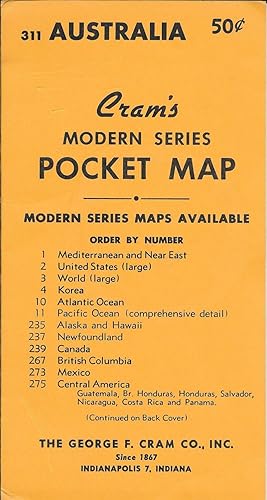
Cram's Modern Series Pocket Map #311 - Australia
Published by George F. Cram Co. Inc. nd, Indianapolis
Seller: Antipodean Books, Maps & Prints, ABAA, Garrison, NY, U.S.A.
Association Member: ABAA ANZAAB ESA ILAB
Seller rating 4 out of 5 stars
Condition: Fine. The map is tipped into its original, 8 �" x 4 �", yellow wrapper that lists the available Modern Series Maps offered by the Cram company on both sides. The colored map unfolds to 16" x 22". A small map on Tasmania is inserted at upper left corner. Someone has used a black marker throughout the Western Australia portion of the map to denote eucalyptus forests, savannah, desert, mallee, and mulga.
-
Africa [and] N. W. Africa, Morocco, Algeria & Tunis.
Published by Geo. F. Cram. (1894)., Chicago., 1894
Seller: Asia Bookroom ANZAAB/ILAB, Canberra, ACT, Australia
Association Member: ANZAAB ILAB
Seller rating 5 out of 5 stars

Chromolithographed maps, 54.3 x 34.1 cm (sheet), central fold, a few small edge tears and marginal age toning, but in very good condition. Detailed maps prepared for George F. Cram's 1894 "Standard American Atlas": one of the first American firms to publish a world atlas. Maps of Oceania and South Africa printed on the verso.
-
Cram's township and shipper's guide of Washington: accompanied by a complete and original ready reference index, accurately locating all counties, county seats, cities, towns, post-offices, railroad stations, villages, etc. . . .
Published by George F. Cram, [1909]., Chicago & New York:, 1909
Seller: Zephyr Used & Rare Books, Vancouver, WA, U.S.A.
Association Member: ABAA CBA ESA ILAB
Seller rating 5 out of 5 stars
First Edition
12mo. 4 x 6.5 in. 45, [3] pp., including illustrated publisher's ads. With 24.75 x 18.5 in. pocket map, points of interest demarcated in red, RR lines in assorted colours, markings, tinted borders (minor edgewear, light creasing, couple small closed tears at folds). Printed tan softcovers (minor rubbing head & foot of spine, creasing to some corners), still VG copy. First edition of this rare Washington State pocket map, detailing all the cities, towns, post offices, railroad stations, villages, and counties, along with telegraph stations and express company offices, providing number of banks in each banking towns, telegraph stations, and more. Of particular interest for this year map are not only the detailed listings of the many railroad and traction company lines across Washington, but also the four under construction, and proposed, including: Big Bend Traction Co., Puyallup Valley Northern Rapid Transit, Snohomish Valley, and Spokane-Pend d'Oreille Rapid Transit Co. No copies in Worldcat.
-

1886 George F. Cram Railroad and Township Map of Arizona
Seller: New World Cartographic, Chicago, IL, U.S.A.
Seller rating 4 out of 5 stars
Map
By: George F. CramDate: 1886 (published) ChciagoDimensions: 17.25 x 23 inches (43.75 x 58.5 cm)This is an 1886 railroad and township map of Arizona by George F. Cram. County lines are drawn in red with the map spanning locations in the southern portion of the state marked along the Southern Pacific Railroad such as Tucson, Wilcox, and Treviston. In the northern portion of the state the Grand Canyon is marked with topographical detail. Also marked near the Grand Canyon are the Mohave and Yavapai territories.In the 1880s Arizona experienced expansive development and frequent conflicts. The Southern Pacific Railroad reached Tucson in 1880, connecting Arizona to major markets throughout the United States. The railroad soon extended to Yuma and Maricopa, fostering town and industry growth.In 1886, the year of this maps publishing, the surrender of Apache leader Geronimo near Fort Bowie marked the end of the Apache Wars, allowing for more stable settlement. Mining towns like Tombstone and Bisbee thrived during the silver boom, while Phoenix developed as an agricultural hub.Several Native American territories of note are marked as well, such as the Moqui reservation and Navajo reservation. This map dates to the same year that Native American children were forced to attend settler schools, a major turning point in the colonial history of the area.Condition: This map is in A condition. Slightly toned with subtle darkening toward outer margins. Residual tape mark along top edge. Centerfold reinforced on the verso with archival tape.Inventory #127861200 W. 35th St. #425 Chicago, IL 60609 | P: (312) 496 - 3622.
-

Oregon. Oregon and Western Colonization Company.
Publication Date: 1911
Seller: Geographicus Rare Antique Maps, Brooklyn, NY, U.S.A.
Association Member: ABAA ESA ILAB
Seller rating 4 out of 5 stars
Map
Fair. Wear along original fold lines. Several areas of infill at fold intersections and along fold lines. Some soiling. Size 28 x 35.25 Inches. This is a 1911 George Cram map of Oregon published for the Oregon and Western Colonization Company (OWC). The grant lands offered for sale here were the fruit of a 'most unblushing fraud upon the government' perpetrated in the late 19th century by the Willamette Valley and Cascade Mountain Wagon Road Company. A Closer Look Coverage embraces the state of Oregon with red and green checker patterns highlighting land offered for sale by the Oregon and Western Colonization Company - a broad corridor extending from Linn County southeasterly as far as Malheur County. Green acreage is designated for logging, while red marks agricultural land. A key explaining this occupies the upper right corner. Bold black lines illustrate railroads. Cities, towns, and villages are labeled throughout, and an index of railroads and electric railroads appears above the Oregon border. The Oregon and Western Colonization Company The Oregon and Western Colonization Company (OWC) was founded in May 1910 by investors in St. Paul, Minnesota. It acquired over 800,000 acres of land in central Oregon from the defunct Willamette Valley and Cascade Mountain Wagon Road Company, which they planned to sell to settlers for between $15 and $200 an acre. The Willamette Valley and Cascade Mountain Wagon Road Company The land grants offered for sale here date to the second half of the 19th century. In 1866, the Willamette Valley and Cascade Mountain Wagon Road Company (WVCM), a well-intended group formed by Linn County farmers, ranchers, and lumbermen, constructed a rough wagon road from Lebanon to Camp Polk (Sisters) on the Deschutes River. Known as the Santiam Wagon Road, the route proved popular, and the WVCM profited handsomely from tolls and road services. When the federal government began authorizing massive land grants to road and railroad builders, the WVCM put in an application that included an exaggerated claim that the existing Santiam Wagon Road was a massive road, built in response to an 1866 congressional bill, that would eventually extend from Albany to the Snake River. The WVDM proposal leveraged kernels of truth with exaggerations, lies, misinformation, and other tricks to maximize their grant. First, they fraudulently claimed a pre-existing road between Albany and Lebanon as their work. Second, they lied about the dates, suggesting that the Santiam Wagon Road was actually built in response to the 1866 bill when it predated the bill considerably. Third, they used the lack of detailed mapping of central Oregon to introduce an erratic, unnecessarily winding route with multiple turns and switchbacks, thus maximizing the area of the grant. Finally, they bribed official agents to 'certify' the unfinished road on the state level, thus confirming the grant. Decades later, in 1880, at least three dozen homesteaders discovered that their lands had been, at least in name, appropriated by the WVCM. In the hope of annulling the grant, they sent an appeal to the Department of the Interior, arguing that the WVCM 'never built or constructed any road as the laws of this State require roads of that character.' They also argued that 'there has been no attempt to open or construct any road' between Smith's Rock and the Snake River, a distance of 300 miles. The Secretary of the Interior sent an investigator who discovered that 'from Cache Creek eastward to the State line it is very manifest that the terms of the grant have not been complied with.' The Department of the Interior nonetheless deferred a decision on the matter to Oregon's state government. Oregon investigated in 1885, and the Secretary of the Interior opened a new investigation in 1887, which concluded that the Willamette Valley road was a 'most unblushing fraud upon the government'. In 1889, the Department of the Interior took the WVCM to court. The Supreme Court ultim.

![Seller image for Africa [and] N. W. Africa, Morocco, Algeria & Tunis. for sale by Asia Bookroom ANZAAB/ILAB](https://pictures.abebooks.com/inventory/md/md31208508236.jpg)