
Order Total (1 Item Items):
Shipping Destination:

Map Southeast Asia (42 results)
Skip to main search results
Search filters
Product Type
- All Product Types
- Books (9)
- Magazines & Periodicals (No further results match this refinement)
- Comics (No further results match this refinement)
- Sheet Music (No further results match this refinement)
- Art, Prints & Posters (No further results match this refinement)
- Photographs (No further results match this refinement)
- Maps (33)
- Manuscripts & Paper Collectibles (No further results match this refinement)
Condition Learn more
- New (1)
- As New, Fine or Near Fine (No further results match this refinement)
- Very Good or Good (No further results match this refinement)
- Fair or Poor (No further results match this refinement)
- As Described (41)
Binding
Collectible Attributes
- First Edition (4)
- Signed (No further results match this refinement)
- Dust Jacket (No further results match this refinement)
- Seller-Supplied Images (39)
- Not Print on Demand (42)
Language (2)
Free Shipping
Seller Location
Seller Rating
-

Condition: NEW.
-

Southeast Asia Chronicle, Issue No. 63, July-August 1978: Succession Crisis in Indonesia: A Dictatorship Self-Destructs
Published by Southeast Asia Resource Center, Berkeley, CA, 1978
Seller: Ground Zero Books, Ltd., Silver Spring, MD, U.S.A.
Seller rating 4 out of 5 stars

First Edition
Wraps. Tam, Frank (Map); Finley, Lowell (Photograph) (illustrator). 28 cm. 22 pages. Ilustrations. Map. Notes. Footnotes. Front cover torn. Half of back cover gone. Continues numeration of: Indochina chronicle. First issue under the new name. Founded in 1971 to inform the American people, legislators, and media about the war in Indochina as well as disseminating information about Laos, Cambodia and Vietnam; changed name to Southeast Asia Resource Center in 1976; absorbed by Asia Research Center in 1982. Fair. Mailing laber on rear cover. Has some wear and soiling. Presumed first edition/first printing thus.
-
Southeast Asia Chronicle, Issue No. 61, March-April, 1978: Laos Recovers from America's War
Published by Southeast Asia Resource Center, Berkeley, CA, 1978
Seller: Ground Zero Books, Ltd., Silver Spring, MD, U.S.A.
Seller rating 4 out of 5 stars
First Edition
Wraps. Tam, Frank (Map); Finley, Lowell (Photograph) (illustrator). 28 cm. 20 pages. Ilustrations. Map. Continues numeration of: Indochina chronicle. First issue under the new name. Founded in 1971 to inform the American people, legislators, and media about the war in Indochina as well as disseminating information about Laos, Cambodia and Vietnam; changed name to Southeast Asia Resource Center in 1976; absorbed by Asia Research Center in 1982. Good. Mailing laber on rear cover. Has some wear and soiling. Presumed first edition/first printing thus.
-

East Indies. Mercators Projection. Map No. 316.
Published by H.E.C. Robinson Pty. Ltd. circa1940., Sydney., 1940
Seller: Asia Bookroom ANZAAB/ILAB, Canberra, ACT, Australia
Association Member: ANZAAB ILAB
Seller rating 5 out of 5 stars

Full colour folding map, 71 x 97 cms; 76.2 x 10² cms (sheet), blank on verso, save for a neat inked stamp "East Indies", inset map of New Guinea and Papua, heights shown by colour, very good, clean condition. Large scale World War II era map by Sydney publisher H. E. C. Robinson. Extremely detailed map, it is coloured according to height above sea level and showing naval bases, railways, shipping routes, air routes. Includes smaller inset map of "New Guinea & Papua" showing the eastern part of the island.
-
Pacific Ocean. Robinsons New Map of the Pacific Ocean with Insets Showing Island Groups in Detail. Map title: Map of Pacific Ocean. Mercators Projection.
Published by H.E.C. Robinson. (Circa1930s)., Sydney, 1930
Seller: Asia Bookroom ANZAAB/ILAB, Canberra, ACT, Australia
Association Member: ANZAAB ILAB
Seller rating 5 out of 5 stars
Printed colour maps in all 65.5 x 99cm, the main map roughly 50 x 65 cms, on a single sheet 76 x 101.3 cms; a little carelessly folded, decorative blue title cover, a little dusty and a few fold splits and edgewear, but in good condition. The exceptional feature of this map are the twenty six large scale inset maps of Pacific islands including: Malay States, Singapore, Hong Kong (these at lower left), Japan, Philippine Islands, Hawaiian Islands, Fiji, Solomon Islands, Western and Eastern Samoa, Tahiti, Saipan, New Caledonia and Dependencies, and many others. The main map of the Pacific Ocean stretches from Southeast Asia, including all of Australia and New Zealand, the west coast of the Americas, the Kamchatka Peninsula, Manchukuo (Manchuria) and most of China. Korea and Taiwan are marked as Japanese Territory. Possessions of Britain, France, the Netherlands and the United States are highlighted. An incredibly rich source of information on the Pacific theatre during the years leading up to World War II. From the Sydney publisher H.E.C. Robinson, the firm founded in 1895 by Herbert Robinson (1857-1933), a founder of the Royal Geographical Society of Australasia.
-
??????????????. [Hit? oyobi Higashi Indo Shot? h?men senkyoku y?zu]. [Japanese Campaign Map of the Philippines and Dutch East Indies Areas].
Published by [Japan]., 1942
Seller: Asia Bookroom ANZAAB/ILAB, Canberra, ACT, Australia
Association Member: ANZAAB ILAB
Seller rating 5 out of 5 stars
Colour map, 21 x 50.5 cm, centrefold as issued. Faint dampstain to upper edge, centrefold a little browned. Good copy. Map of Southeast Asia, including Borneo and the Philippines and New Guinea. Of particular interest is the small inset map of Singapore at lower left. The war situation of the Japanese army in 1941 and 1942 during the Pacific War is clearly shown with one sheet. Text in the inset plan of Singapore says "Occupation of Singapore in February 15 (1942)".
-
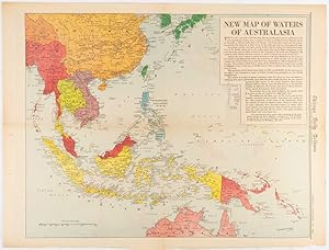
New Map of Waters of Australasia.
Published by Chicago Daily Tribune. December 161942., Chicago., 1619
Seller: Asia Bookroom ANZAAB/ILAB, Canberra, ACT, Australia
Association Member: ANZAAB ILAB
Seller rating 5 out of 5 stars
Printed colour map on a single newspaper leaf 41.6 x 52.8 cm; 45 x 60 cm (sheet), inset legends, marginal browning and at the folds, but remarkably bright, in very good condition. Map of Southeast Asia published in the Chicago Daily Tribune "The World's Greatest Newspaper" delineating the Pacific theatre of war with a detailed text legend. "This is a new war map of the far east, showing an important part of southeastern Asia and Australasian waters, from a station in which, according to Prime Minister Curtin of Australia, a United States fleet will operate." Interestingly New Guinea is marked as British, rather than as an Australian administrative region which it became following the Treaty of Versailles. "? the historic Chicago Tribune was an innovator in color inks and printing, but also a pioneer in bringing colorful art in the form of illustrations, photographs, cartoons and advertisements to the average person in an everyday medium." [see The Janet A. Ginsburg Chicago Tribune Collection, Michigan State University Libraries.].
-
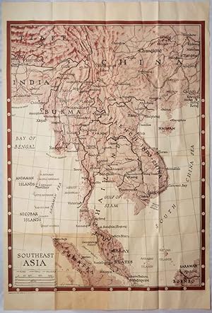
Southeast Asia. Orientation Map Series No. 6.
Published by Army Orientation Branch, USGPO, Washington, D.C., 1944
Seller: Asia Bookroom ANZAAB/ILAB, Canberra, ACT, Australia
Association Member: ANZAAB ILAB
Seller rating 5 out of 5 stars
Very large folding two-colour map, 138.5 x 101 cms; sheet 157.3 x 105.5 cms, folded to sixteenths, 39.5 x 26.5 cms (as issued),toning to a lower left panel and the central fold, some small holes at some of the fold points but now repaired on th verso with archival washi, generally in very good condition. Colour map of the extended area from the Ganges and Calcutta to Hong Kong, and from Tibet and Hankow in China to Singapore, with part of Sarawak and Borneo and the northern part of Sumatra, together with the Andaman and Nicobar Islands. The McMahon line delineating the border between Tibet and India is not observed, nor the 1941 border established between France and Thailand (following the Mekong River). This map is by the Chicago Sun cartographer F. E. Manning, produced for the Army Orientation Branch. A smaller version was also included with the Newsmap issue of January 17th 1944.
-

Southeast Asia. Orientation Map Series No. 6.
Published by Army Orientation Branch, USGPO, Washington, D.C., 1944
Seller: Asia Bookroom ANZAAB/ILAB, Canberra, ACT, Australia
Association Member: ANZAAB ILAB
Seller rating 5 out of 5 stars
Very large folding two-colour map, 138.5 x 101 cms; sheet 157.3 x 105.5 cms, folded to sixteenths, 39.5 x 26.5 cms (as issued), toning to a lower left corner panel and to the folds, four small fold splits wthout loss to the map, now repaired on the verso with archival washi, generally in very good condition. Colour map of the extended area from the Ganges and Calcutta to Hong Kong, and from Tibet and Hankow in China to Singapore, with part of Sarawak and Borneo and the northern part of Sumatra, together with the Andaman and Nicobar Islands. The McMahon line delineating the border between Tibet and India is not observed, nor the 1941 border established between France and Thailand (following the Mekong River). This map is by the Chicago Sun cartographer F. E. Manning, produced for the Army Orientation Branch. A smaller version was also included with the Newsmap issue of January 17th 1944.
-
![Seller image for [Kingdom of Ayutthaya]. for sale by Geographicus Rare Antique Maps](https://pictures.abebooks.com/inventory/md/md32307609487.jpg)
[Kingdom of Ayutthaya].
Publication Date: 1957
Seller: Geographicus Rare Antique Maps, Brooklyn, NY, U.S.A.
Association Member: ABAA ESA ILAB
Seller rating 4 out of 5 stars
Map
Average. Manuscript. Overall toning. Color loss and surface scuffing. A few small holes. Laid down on old linen. Size 43 x 31.5 Inches. This is a large-format Thai-language c. 1957 manuscript historical wall map of Southeast Asia. It depicts the historical Kingdom of Ayutthaya, forerunner to modern Thailand, with a very generous border, a reflection of the ideological values of Pan-Thaiism. A Closer Look The map presents an aggrandized view of the territory of the Kingdom of Ayutthaya (1351 - 1767), stretching from what is today southern China to the Malay Peninsula and incorporating all of today's Thailand, Laos, and Cambodia, along with portions of China, Myanmar (Burma), and Vietnam. It is likely meant to resemble the putative territory of the kingdom during the reign of King Naresuan, also known as Naresuan the Great (r. 1590 - 1605). Coverage includes from Chittagong (????????) in today's Bangladesh at top-left to southern China (the Leizhou Peninsula and Hainan Island) at top-right, to Malacca (??????), the Malacca Straits, and Sumatra at bottom. Color-shading indicates the borders of kingdoms and territories, which are labelled in larger text (China ???, Malay ?????, and India ???????, among others, in addition to Ayutthaya), while many cities are noted throughout with red circles. Among Thai cities are those that are now large and well-known internationally like Chiang Mai (?????????), as well as smaller cities that were among the largest in the era of Ayutthaya Kingdom, such as it capital, Ayutthaya (??????, on the Chao Praya River not far from where Bangkok would later develop), Phitsanulok (????????), and Lopburi (??????), and Nan (????). Several cities are depicted as part of Ayutthaya but are not now part of neighboring countries, such as Vientiane (Lan Xang, ????????), Luang Prabang (??????????), and Battambang (????????), while several cities beyond the rule of Ayutthaya are easily recognizable by names they retained into the modern era, such as Hu? (???), Saigon (??????), and Taungoo (?????). Thai Irridentism and Historical Cartography The map reflects a strain of Thai irridentism and nationalism, known as Pan-Thaiism, that became pronounced in the 20th century, namely after the 1932 revolution, which transitioned the country from an absolute monarchy to a constitutional monarchy under a civilian-military regime. This ideology gained prominence particularly during the 1930s and early 1940s under the leadership of Field Marshal Plaek Phibunsongkhram (Phibun, 1897 - 1964), when the intellectual and statesman Luang Wichitwathakan (????????????????, 1898 - 1962) largely formulated it. This ideology was driven by two motives: the first being a claim that all Thai peoples in Southeast Asia were part of a single 'Thai Race,' and the second that Thailand (renamed from Siam in 1939 to emphasize Thai identity) needed to 'reunify' these peoples in a single political entity and reclaim lands that had historically been 'stolen' by malign foreign powers, both near (Burma) and far (France, Britain). These beliefs led Phibun to align with Japan after the Fall of France in 1940, which presented an opportunity to reclaim land in French Indochina. In exchange for facilitating Thai irredentism, Japanese forces were allowed to use Thailand as a staging ground for their invasions of British Malaya and Burma in December 1941. This alliance proved to be a major liability and caused Phibun to be removed from office in 1944 (he returned to power in the postwar period), though the United States took a more forgiving approach towards Thailand than the British and French, laying the foundations for a close relationship, including a military alliance, during the Cold War. From the 1930s, several cartographic projects aimed to establish historical legitimacy for Pan-Thaiism. At that time, maps began to be produced that claimed implausibly large borders for the greater Thai nation or race, often referring to the Ayutthaya Kingdom and especial.
-
Map of the Kingdoms of Siam and Cochin China.
Publication Date: 1828
Seller: Geographicus Rare Antique Maps, Brooklyn, NY, U.S.A.
Association Member: ABAA ESA ILAB
Seller rating 4 out of 5 stars
Map First Edition
Good. Some wear along old fold lines. Repaired and reinforced split along bottom horizontal fold. Some discoloration and repair where originally tabbed into volume, at center. Laid down on archival tissue. Size 37 x 25 Inches. This rare large-format 1828 map of Southeast Asia, compiled by John Walker to illustrate John Crawfurd's mission to Siam (Thailand), is the first accurate survey of the coasts of Siam. Coverage extends from China to Singapore and from the Gulf of Martaban (Burma) to Vietnam and Hainan. Siam at the time was inaccessible to European merchants and even diplomats, with its coasts and interior largely unknown. This map is an amalgam of European sources, but with regard to Siam, it was derived primarily from secretly acquired early 19th-century Siamese surveys previously unknown to Europeans and, for all intents and purposes, still lost. Historical Context Following the resurgence of the Kingdom of Siam after the Burmese-Siamese War (1765 - 1767), Siam emerged as a major political power and the central state in Southeast Asia. The regional destabilization following Siamese victory led to a power vacuum in Burma, which precipitated a series of further conflicts, both between Siam and Burma and between Burma and Great Britain, lasting well into the early 19th century. The British took advantage of the weak Burmese military to seize additional territory in Assam, Manipur, and Arakan during the First Anglo-Burmese War (1824 - 1826). At the same time, Siam continued to grind away at both Burmese territory to the west and parts of Laos and Cambodia to the east, stopped only by Vietnamese and French forces in Indochina. To the south, Britain exerted a strong influence over the Malay States, leaving only Siam as a fully independent and powerful Southeast Asian state resistant to European influence. The Crawfurd Mission The Scottish linguist, diplomat, doctor, and colonial administrator John Crawfurd (1783 - 1868) was sent to the Kingdom of Siam by the Governor-General of India, Lord Francis Edward Rawdon-Hastings (1754 - 1826). Hastings was interested in evaluating the growing power of Siam, acquiring a reliable reconnaissance of Siamese lands, establishing trade relations, and understanding Siamese policy with regard to both the Malay States to the south (particularly Penang, to which the British had laid claim) and to French attempts to establish a colonial presence in Vietnam. While the mission failed to establish trade relations, evaluate Siamese political positions regarding Penang, or explore the interior, Crawfurd did collect cartographic materials detailing the coast, much of which John Walker compiled into this map. The 'Mohammedan Mariner' In the appendix to Crawfurd's Journal of an Embassy from the Governor-General of India to the Courts of Siam and Cochin-China , he lists the sources of this remarkable map. Many are new surveys conducted en route , earlier British surveys of the Malay States and Bengal, and French sources for Indochina, but the bulk of the map as it relates to Siam is based upon cartography passed clandestinely to Crawfurd by a Siamese Muslim navigator. To quote Crawfurd, From the Cape of Patani to the point of Kwiis taken from a Mohammedan mariner, a native of Siam, possessed of considerable intelligence-who was acquainted with the use of maps and the quarterstaff, and could even take an altitude of the sun with our quadrants. he goes on to describe how this same mariner, in fear of his life, divulged less and less information the closer the came to Siam, .a great deal of useful information . as we approached Siam they became much more shy and reserved, and now communicated nothing without a strict injunction to secrecy. They constantly resisted our solicitations to assist in translating the Governor-general's letter into Siamese, observing that the communication of his Majesty's titles would be considered as the divulgement of a state secret, which might cost them their lives. The comman.
-

Asiatic Archipelago on Mercator's Projection.
Publication Date: 1906
Seller: Geographicus Rare Antique Maps, Brooklyn, NY, U.S.A.
Association Member: ABAA ESA ILAB
Seller rating 4 out of 5 stars
Map
Very good. Dissected and mounted on linen as issued. Boards removed but present. Size 19.75 x 24.5 Inches. This is John Arrowsmith's map of Southeast Asia and the East Indies in an updated c. 1906 issue published by Stanford. This map achieved astonishing longevity via frequent updates, having first appeared in 1832. A Closer Look Though it retains Arrowsmith's notations - for example, pointing out the best seasonal routes to China and describing the catastrophic 1815 volcanic eruption of Mount Tambora - the map would be amended as early as 1848. From its earliest inception, the map included the inset of Singapore Island. An additional inset featuring Lab�an Island (surveyed by Captain Sir Edward Belcher and Lieut. D. M. Gordon) appears on examples of the map as early as 1848 - an impressively up-to-the-minute change, as the survey in question was not published by the Admiralty until 1847. Hong Kong is outlined in red. The French and British spheres of influence near Siam are also outlined in red, roughly conforming to the treaties between France and Siam following their 1893 war. Guam's spelling has been altered from the earlier 'Guahan,' and its association with the United States is noted. New Guinea (completely undefined in Arrowsmith's first iteration of the map) has had its coastline completed and its interior mapped. Its borders reflect the division of the island between the Netherlands, Great Britain, and Germany between 1884 and 1919, with German New Guinea named 'Kaiser Wilhelm Land.' Throughout the map's publication, the interiors of Borneo, Singapore, and Australia were completely reworked. Railways Railways are traced in Burma, Siam, French Indochina, Java, the Philippines, and Australia. The North Australian Railway can be seen at its extent in about 1889; it does not yet (as it would in 1917) reach the Katherine River. The map shows the Singapore-Kranji Railway bisecting Singapore Island; this railway was completed in 1903, as was the line in British North Borneo from Beaufort to Jesselton. A further extension of this railway from Beaufort to Tenom was completed in 1906; this branch appears on the map. Publication History and Census John Arrowsmith first published this map in 1832; it would remain in publication, assiduously updated and amended, apparently for over a century (OCLC shows a 1936 example). The extent of the railways in British North Borneo suggests an early date of 1906 for the map. The colonial borders in New Guinea would tend to indicate a date no later than 1918. References: OCLC 947046833.
-

India.
Publication Date: 1865
Seller: Geographicus Rare Antique Maps, Brooklyn, NY, U.S.A.
Association Member: ABAA ESA ILAB
Seller rating 4 out of 5 stars
Map
Very good. Original centerfold. Size 13 x 16 Inches. This is Karl von Spruner's 1865 map of India and Southeast Asia in antiquity. This map covers the entire subcontinent as well as Southeast Asia, Sumatra, and Ceylon. In addition to the main map, there are five insets. The upper left inset offers a general view of the region from Arabia to Sumatra including the Indian Ocean. The lower left inset maps reveal India as it was depicted in antiquity by the Alexandrian cartographer Ptolemy and in the ancient Roman map known as the Peutinger Table. The upper right hand map is an early Renaissance take on Ptolemy in which India has been reduced and Taprobane, or Ceylon, is increased to vast proportions. In general this map labels important cities, rivers, mountain ranges and some other topographical details. Territories and countries outlined in color. The whole is rendered in finely engraved detail exhibiting throughout the fine craftsmanship of the Perthes firm. References: Rumsey 1626.029. Phillips (atlases) 3288. Espenhorst, J., Petermann's Planet, p. 397-404. Espenhorst, J., Andree, Stieler, Meyer & Co., p. 148.
-
![Seller image for [Laos between the Blocs]. for sale by Geographicus Rare Antique Maps](https://pictures.abebooks.com/inventory/md/md32307616365.jpg)
[Laos between the Blocs].
Publication Date: 1960
Seller: Geographicus Rare Antique Maps, Brooklyn, NY, U.S.A.
Association Member: ABAA ESA ILAB
Seller rating 4 out of 5 stars
Map
Very good. Some light toning in lower right margin. Size 13 x 18.5 Inches. This is a c. 1960 map of Southeast Asia produced by the Israeli cartographic firm Carta for Ben-Zion Luria's A?las Yedi'ot Aharonot . It highlights the Cold War ideological struggles in the region, particularly the Laotian Civil War (1959 - 1975). A Closer Look The map covers from southern China and northern Burma southwards to northern Malaysia and Borneo, focusing on Mainland Southeast Asia. Communist countries (China and North Vietnam) are shaded red, while U.S.-aligned countries are shaded blue, including Laos, Cambodia, South Vietnam, the Philippines, Thailand, the Republic of China (on Taiwan), and the eastern portion of Pakistan (now Bangladesh). Pakistan, the Philippines, and Thailand, along with the U.S., were members of the Southeast Asian Treat Organization (SEATO ; ???? - ???? ????? ????? ???? ????), modelled on the North Atlantic Treat Organization (NATO). The SEATO headquarters in Bangkok is noted with a text box at left, while an air supply route from Manila to Mainland Southeast Asia is traced (a similar air route for Communist forces is noted between Hanoi and the Pathet Lao-controlled parts of Laos). A textbox in the South China Sea explains the end of French colonialism in Indochina and the division of Vietnam according to the 1954 Geneva Accords. Additional text boxes and explanatory notes point out the wartime capital of the Pathet Lao at Viengxay, a helicopter base in northern Thailand (Nakhon Phanom Royal Thai Air Force Base), and the fact that Okinawa was under U.S. military administration. Cities, major roads, and railways are also recorded throughout. Laotian Civil War and the Vietnam War This map was created in the early stages of the Laotian Civil War (1959 - 1975), fought between the Communist Pathet Lao and the Royal Lao Government. The Laotian Civil War became entangled with the Vietnam War (1955 - 1975) and became a proxy war between Cold War powers, meaning that not only were the opposing Laotian forces fighting each other but that North Vietnamese, American, Thai, and South Vietnamese forces were also involved, with the Pathet Lao receiving supplies from Communist China and the Soviet Union. The Ho Chi Minh Trail, a key logistical artery for the North Vietnamese to infiltrate men and supplies into South Vietnam, traversed most of the length of Laos before entering South Vietnam. Communist Pathet Lao forces emerged victorious at the end of the war in 1975, with up to 300,000 people fleeing Laos into Thailand after their takeover. Israel's role in all this was minimal; although many Zionists were socialists of one stripe or another and the Soviet Union supported Israel in its early years, the State of Israel eventually aligned with the anti-Communist bloc in the Cold War, while the Soviet Union supported Arab states. However, the close attention to detail in this map reflects a desire to understand distant battlegrounds in the emerging Cold War and Israel's place in the global confrontation. Publication History and Census This map was prepared by Amnon Soferman (????? ??????) and Emmanuel Hausman (?????? ??????) of Carta, the Jerusalem-based cartographic firm that the two men founded. It was printed by Emil Pikowsky (???????? ????), son of Michael Pikowski, the father-son team who were pioneers of Israel's printing industry, with pattern printing by Offset-Printing Siyon Ltd. (????-????? ???? ??"?). The map appeared in the At?las Yedi'ot Aharonot (???? ?????? ???????), edited by Ben-Zion Luria, arranged by the Yedi'ot Aharonot ( Latest News ), a newspaper in Tel Aviv, and published by the Kiryat Sefer Publishing House (????? ???). An atlas with this title was published for many years by the newspaper between the 1930s and 1990s. Although the map is not dated, its style and content would suggest that it was published in an edition of the atlas from the early 1960s. The map is not individually cataloged with any institution.
-

Tabula Asiae XI.
Publication Date: 1561
Seller: Geographicus Rare Antique Maps, Brooklyn, NY, U.S.A.
Association Member: ABAA ESA ILAB
Seller rating 4 out of 5 stars
Map
Very good. Soiling to margins and faint offsetting. Neat manuscript notation and embellishment of cities in an old hand. Size 7.25 x 9.25 Inches. This is a handsome example of Girolamo Ruscelli's 1561 / 1574 map of Southeast Asia and the Malay Peninsula. The region was known to ancient geographers as 'India Extra Gangem,' or 'India Beyond the Ganges'. A Closer Look The map thus embraces Thailand, Burma, and Vietnam, reaching from the tip of the Malay Peninsula to the Himalayas in the north. The Ganges River is clearly shown and named. The Aurea chersonensis (the Malay Peninsula, possibly inclusive of Sumatra) and Aurea regio (Burma, generally) speak to the allure the region held to European armchair explorers (Aurea = Golden.). The map portrays two bodies of water, both with an array of named islands: the Indian Ocean (Mare Indicum) and the Sinus Magnus (the Great Bay). Beyond the Great Bay to the east is another coastline. This, according to Ptolemy's geography, was China . Cartographic Context Ptolemy considered the Indian Ocean to be an inland sea, with the southern part of Africa continuing eastward to meet China beyond the Malay peninsula. The Sinus Magnus was the body of water enclosed by Malay Peninsula and the landmass encircling the whole of the Indian Ocean. Certainly, the modern maps included in the editions of Ptolemy produced by Ruscelli and his contemporaries showed that by this time it was well understood that such a 'land bridge' between Africa and China did not exist - although some early mapmakers speculated that the eastern shore of the Sinus Magnus might actually have been the newly-discovered American Pacific coastline. The city of Cattigara , appearing in the extreme southeast of the present map, can be found on the South American coastline on the 1540 M�nster America and the Oronce Fine world map produced the same year. Ancient Cartography Revisited Ruscelli's La geografia di Claudio Tolomeo Alessandrino was firstly a definitive edition of Ptolemy's ancient geographical text, and so Ruscelli's 16th-century maps shared a binding with maps like this one which reflected 2nd -century geographical knowledge. Ruscelli was not the only late Renaissance geographer to publish Ptolemy's work. The ancient maps in this edition were largely derived from the works issued by Giacomo Gastaldi in 1548, which in turn was much derived from Sebastian M�nster's work of 1540. Publication History and Census The map was engraved by Giulio Sanuto for inclusion in Ruscelli's 1561 La geografia di Claudio Tolomeo Alessandrino , and the plate appeared in all editions of that work. The separate map is cataloged in 9 institutional collections, although it does appear on the market from time to time. The maps of the 1561 edition were engraved two-to-a-plate, and consequently, the platemark runs off the edge of the sheet at top for the 1561, 1562 and 1564 printings. Afterward, the plates were divided, and examples from 1574 onwards, as here, exhibit a platemark all around the map; furthermore, the plate shows considerable evidence of reworking, in many cases simplifying the form of the mountains to improve clarity. In 1599, letterpress was added to the upper border. The present example conforms typographically to the 1574 edition. We see about ten examples of this separate map cataloged in OCLC, in various editions. References: OCLC 7470062. Rumsey 11311.058. Curtis, R. and Durand, Fr. Maps of Malaysia and Borneo: Discovery, Statehood and Progress, no. 2.
-
![Seller image for Hoa Do? Saigon Va Vung Phu Cun. / [Map of Saigon and its Suburbs.] for sale by Geographicus Rare Antique Maps](https://pictures.abebooks.com/inventory/md/md32068511394.jpg)
Hoa Do? Saigon Va Vung Phu Cun. / [Map of Saigon and its Suburbs.]
Publication Date: 1968
Seller: Geographicus Rare Antique Maps, Brooklyn, NY, U.S.A.
Association Member: ABAA ESA ILAB
Seller rating 4 out of 5 stars
Map
Good. Verso repair and reinforcement to old fold lines. A few minor margin tears reinforced on verso. Light infill and soiling. Size 23.75 x 18 Inches. This is a rare 1968 map of Saigon and its suburbs, issued in Saigon at the height of the Tet Offensive, when the city was under siege by Viet Cong and North Vietnamese forces. Saigon c. 1968 This map is a clear representation of the geography of Saigon, situated on the Saigon River and its tributaries with two historical urban centers at Cholon towards bottom-left and old Saigon towards right-center. Cholon was historically inhabited by overseas Chinese and was the largest concentration of the Hoa (Chinese) ethnic minority in Vietnam. Although they were important for commerce with the outside world, the Chinese population was often looked at with suspicion and even hatred by local rulers. As a threatened minority, the Hoa cooperated with outside forces, namely the French and Americans, as a means of protection, which caused them to be targeted again once Vietnam was reunified in 1975. As for Saigon, the pre-existing city dates back centuries but grew significantly under the Nguyen lords in the 18th century. It was renovated by the French starting in the 1860s to craft it into an ideal colonial city, with a set of new structures including an opera house, a cathedral, and a palace, initially built for the King of Cambodia but later to become the home of Saigon's colonial governors (it was damaged in an assassination attempt against Ngo Dinh Diem in the 1960s and rebuilt as 'Independence Hall'). Also worth noting are the three large park areas shaded green: from left-to-right the Ph� Th? Horse Racing Ground, Tao Dan Park, and the Saigon Zoo and Botanical Gardens. Finally, the T�n S?n Nh?t Airfield (now T�n S?n Nh?t International Airport) is very prominent towards top-center. Wider Context This map was published in 1968, the same year as the surprise Tet Offensive by Viet Cong and North Vietnamese forces. The offensive targeted Saigon with the intention of weakening the South Vietnamese government and launching guerrilla attacks on symbolically important sites rather than capture the city. Running battles in the streets raged from the end of January through early February, with major battles at the Airfield (at that point primarily operating as an air base for the U.S. and South Vietnamese forces), the Horse Racing Ground, and Cholon District, where many civilians were killed in the fighting and in U.S. airstrikes. In late April and May, a second attack by Viet Cong and North Vietnamese forces was launched on Saigon, especially the western and southern parts of the city. Again, the attacks were repulsed with the attackers suffering heavy losses. In the end, although Saigon remained in South Vietnamese government hands, the ability of Communist forces to launch so many attacks on and inside the capital dealt a serious psychological blow, and Communist forces continued to control much of the surrounding countryside. Cholon and some other areas were badly damaged in the fighting and refugees had to be housed on the Racing Grounds. For the U.S. side, the high number of casualties caused by the Tet Offensive turned public opinion against the war and motivated a policy of 'Vietnamization' under the new Nixon Administration in 1969, the beginnings of U.S. withdrawal. The Tet Offensive January 30, 1968 marked the beginning of the Tet Offensive (January 30, 1968 - September 23, 1968), one of the largest North Vietnamese / Vietcong offensives of the Vietnam War. The Tet Offensive comprised of coordinated surprise attacks targeting both military and civilians. All told, the North Vietnamese struck more than 100 towns and cities, including Saigon, the capital of South Vietnam, and 36 of 44 provincial capitals. U.S. forces were caught unprepared and by the second week of February had suffered over 9000 casualties. Publication History and Census This map was published by the Southeast Asia Pr.
-

Jap's Eye View.
Publication Date: 1944
Seller: Geographicus Rare Antique Maps, Brooklyn, NY, U.S.A.
Association Member: ABAA ESA ILAB
Seller rating 4 out of 5 stars
Map
Very good. Newsprint. Closed margin tears professionally repaired on verso. Size 14.75 x 21 Inches. This is a 1944 Edwin Sundberg map of East Asia, Southeast Asia, and the East Indies, published in the Sunday News in New York City. Sundberg chose to illustrate the region in the opposite orientation from what most of his American audience would have been accustomed to, providing Sunday News readers with a new perspective ('the Japanese point of view) on the continued push across the Pacific toward Japan. A Closer Look The map is oriented to the South with coverage embracing the western Pacific from Hawaii to Chian and from Kamtschka to Australia - thus encompassing the full theater of the Pacific War. The Soviet Union and the Aleutian Islands of Kiska and Attu are illustrated along the bottom border. (Sundberg's readers would have been familiar with these islands since the Japanese invaded them in 1942.) Hawaii is labeled along the left border to help orient Sundberg's audience but does not appear on the map. Japan, Korea, and part of Sakhalin are shaded orange to highlight Japan's home territory. An orange border encircles territory conquered by the Japanese, including Manchuria, coastal China, the Philippines, most of Southeast Asia, and the East Indies. Two orange lines illustrate Japan's outer and inner defensive lines, including the Marshall Islands, Marianas Islands, Gilbert Islands, and the Caroline Islands. Air and sea routes are illustrated throughout. A short text in the lower right explains the map's perspective. Sundberg states the map looks 'out from Tokio [sic] to the south.' He continues to explain that, after expanding their territory, Japan encountered severe supply issues that could not be sustained. American victories began restricting supplies and caused Japan to create defensive strategies. He even speculated that Japan would leave the Home Islands to their fate and would fight the war's final battles in Manchuria. Publication History and Census This map was drawn by Edwin Sundberg and published by the Sunday News on April 23, 1944. We note a single cataloged example, which is part of 'War Map: Pictorial and Propaganda Map Collection 1900-1950' at the Library of Congress. References: Library of Congress G3201.S6 coll War Vault Folder 145.
-

East India Isles.
Publication Date: 1814
Seller: Geographicus Rare Antique Maps, Brooklyn, NY, U.S.A.
Association Member: ABAA ESA ILAB
Seller rating 4 out of 5 stars
Map First Edition
Good. Centerfold stabilized on verso. A few minor margin tears reinforced and repaired on verso. Size 17.5 x 21 Inches. This is the first edition of John Thomson's 1814 map of Southeast Asia and the East India Islands. A Closer Look Centered on Borneo, Thomson's map covers from China and Hainan south to Sumatra and Java, and eastward as far as the Philippines and New Guinea. Includes the Pearl River Delta at its northernmost edge and names Macao and Lantao Island (Hong Kong). The Singapore Straits are identified, as are Bintan and Batam Islands, but the Island of Singapore itself is unnamed. Apocryphal Island of St. John Just to the east of Philippine Mindanao, sets the fictitious island of St. John's. The fiction of St. John's Island originates with the Portuguese cooption of manuscript mappings of this region acquired from the Magellan expedition. Its first published reference is on Ortelius' 1570 Asiae Nova Descripto . Afterward, numerous mariners, including Dampier, claimed to have visited it. However, most were most likely mistaking it for other nearby islands. Over the years, the location of St. John's Island thus migrated westwards towards Mindanao's eastern coast, where it resided until about 1850, when the island finally disappeared from cartographic record. In later variants of this map, Thomson expresses doubt about the island, naming it 'Doubtful', but in this early edition, he seems confident . Publication History and Census This map is a steel plate engraving by Thomas Clerk and was prepared by John Thomson for inclusion in the 1817 edition of Thomson's New General Atlas . This is the 1st edition, with the Clerk imprint under the title. References: Rumsey 1007.043. Phillips (Atlases) 731. Newberry Library: Ayer 135 T4 1817.
-

Carte pour suivre l'Expedition du Tonkin.
Publication Date: 1884
Seller: Geographicus Rare Antique Maps, Brooklyn, NY, U.S.A.
Association Member: ABAA ESA ILAB
Seller rating 4 out of 5 stars
Map
Very good. Light wear along original fold lines. Verso repairs to fold separations and at fold intersections. Two small areas of infill at fold intersections. Size 18.75 x 24.75 Inches. This is an 1884 Eug�ne Andriveau-Goujon map of Southeast Asia and the East Indies published during the French Tonkin Campaign (Exp�dition du Tonkin). The map capitalizes on French public interest in the fighting in Tonkin (Tong-King). Andriveau-Goujon uses color to highlight colonial possessions of France, England, the Netherlands, and Spain, clarifying the politics in play. He also includes numerous cities and towns, along with shipping routes and undersea cables. The Tonkin Campaign The Tonkin Campaign was fought between the French Expeditionary Force, the Vietnamese, and the Black Flag Army, a guerrilla group operating in Tonkin. The French force, intending to exact revenge on the Chinese and the Black Flag Army, had as a final objective the occupation of Tonkin and the establishment of a protectorate. The fighting in Tonkin raged from June 1883 until July 1884 before the Chinese entered the war in earnest and the wider Sino-French War (1884 - 1885) began. The Sino-French War lasted from August 1884 until April 1885, after which the French began a year-long pacification campaign in Tonkin. In April 1886, fighting mostly ended and the expeditionary corps was reduced to a division. Nonetheless, Tonkin was not effectively pacified until about 1896. Publication History and Census This map was created and published by Eug�ne Andriveau-Goujon in 1884. We note a single example cataloged in OCLC, at the Biblioth�que Nationale de France. We also note an additional example at American Geographical Society Library at the University of Wisconsin Milwaukee. References: OCLC 494850447.
-

Southeast Asia. Newsmap. Monday, January 17, 1944. Week of January 6 to January 13. 227th Week of the War - 109th Week of U.S. Participation. Volume II No. 39F.
Publication Date: 1944
Seller: Geographicus Rare Antique Maps, Brooklyn, NY, U.S.A.
Association Member: ABAA ESA ILAB
Seller rating 4 out of 5 stars
Map
Good. Exhibits slight wear and a few minor splits along old fold lines, particularly at fold intersections. Very minor loss at two fold intersections. Old folds stabilized where required with archival tissue on verso. Size 46.75 x 35 Inches. This is a 1944 Morale Services Division Newsmap wall map of Southeast Asia. Created for American personnel serving overseas during World War II, the map depicts the region from Hankou, China to Borneo and Sumatra and from Calcutta to Hong Kong. This was a critical, if little-remembered theater of World War II, but little detail concerning the war appears, likely because that information would be severely out of date by the time the map finally reached its intended audience. The map was intended for general educational use concerning the area's geography, cities and towns are labeled throughout. Larger print identifies important cities, which were the ones that soldiers were more likely to recognize, including Singapore, Mandalay, Hong Kong, Macau, Canton (Guangzhou), and Kunming (the Chinese Nationalist capital), to name only a few. Roads that roughly correspond to the famous Burma Road are included as well, although are not labeled as such. The Verso Content One of the attributes of the Newsmap genre is the abundance of content on one side and large graphic content of some kind (usually a map or propaganda poster) on the other. This edition is not an exception. Ten black and white photographs surround a world map highlighting territory still controlled by the Axis. Short paragraphs situated at top center provide summaries of the week's most important war-related events. In this case, these include fighting between the Nazis and the Soviet Red Army on the Eastern Front, significant raids in the air war over Europe; brutal fighting in southern Italy; and the completion of a jet engine by the Allies. The photographs present the viewer with images of a small Italian village before and after an Allied artillery barrage, three images of U.S. Army Chief of Staff General George Marshall's visit to the Southwestern Pacific to visit General Douglas MacArthur, and three WACs encountering a sacred cow in a Delhi, India bazaar. Publication History and Census The map of Southeast Asia was drawn by F.E. Manning, and the whole was prepared and distributed by the Morale Services Division of the War Department. Ten examples are cataloged in OCLC and are part of the institutional collections at Pennsylvania State University, Denison University, Ohio Wesleyan University, Davidson College, the University of Michigan, the Library of Michigan, the University of Illinois at Urbana-Champaign, Southern Illinois University, the University of Missouri and the Denver Public Library. References: OCLC 416656295.
-

Les Indes Orientales et leur archipel. Assujettie aux observations astronomiq(u)es combinees avec les itineraires anciens et modernes, et avec les routes des navigateurs.
Publication Date: 1778
Seller: Geographicus Rare Antique Maps, Brooklyn, NY, U.S.A.
Association Member: ABAA ESA ILAB
Seller rating 4 out of 5 stars
Map
Very good. Some toning and wear along original centerfold. Minor foxing. Original platemark visible. Size 12.5 x 18 Inches. A beautiful example of Rigobert Bonne's c.1778 map of India, Southeast Asia and the East Indies. Covers from Kandahar and the Maldives in the west eastward to include all of India, Southeast Asia (modern Burma, Thailand or Siam, Malaysia, Cambodia, Vietnam, Laos), the East Indies (Java, Sumatra, Borneo and the Celebes) and the Philippines. Also includes much of Tibet. Identifies countless cities, rivers, waterways, and states throughout the region. The Straight Singapore are labeled 'Sin Capura.' Vietnam is divided into the kingdoms of Tonkin and Chochinchine. Includes the Tip of Formosa or Taiwan. Drawn by R. Bonne for issue as plate no. 26 in Jean Lattre's Atlas Moderne . References: Rumsey 2612.052. Phillips (Atlases) 664. National Maritime Museum, 215.
-

East India Isles.
Publication Date: 1814
Seller: Geographicus Rare Antique Maps, Brooklyn, NY, U.S.A.
Association Member: ABAA ESA ILAB
Seller rating 4 out of 5 stars
Map
Good. Some centerfold toning and offsetting. Size 17.5 x 21 Inches. This is John Thomson's 1814 map of Southeast Asia and the East India Islands. A Closer Look Centered on Borneo, Thomson's map covers from China and Hainan south to Sumatra and Java, and eastward as far as the Philippines and New Guinea. Includes the Pearl River Delta at its northern most edge and names Macao and Lantao Island (Hong Kong). The Singapore Straits are identified, as are Bintan and Batam Islands, but the Island of Singapore itself is unnamed. Apocryphal Island of St. John Just to the east of Philippine Mindanao, sets the apocryphal island of St. John's. The fiction of St. John's Island probably originates with the Portuguese cooption of manuscript mappings of this region acquired form Magellan expedition. Its first published reference is on Ortelius' 1570 Asiae Nova Descripto . Afterwards, numerous mariners, including Dampier, claimed to have visited it, however, most were most likely mistaking it for other islands in the region. Over the years the location of St. John's Island thus migrated westwards towards Mindanao's eastern coast where it resided until about 1850, when the island finally disappeared from cartographic record. In the earliest editions this map Thomson seems confident of St. John's Island, but in this edition, he annotates it with 'Doubtful'. Publication History and Census This map is a steel plate engraving by Thomas Clerk and was prepared by John Thomson for inclusion in the 1817 edition of Thomson's New General Atlas . This is likely the 2nd edition, with the imprint of Clerk removed and minor changes made to the cartography - as noted above. References: Rumsey 1007.043. Phillips (Atlases) 731. Newberry Library: Ayer 135 T4 1817.
-
Charte von Ostindien diesseits und jenseits des Ganges.
Publication Date: 1804
Seller: Geographicus Rare Antique Maps, Brooklyn, NY, U.S.A.
Association Member: ABAA ESA ILAB
Seller rating 4 out of 5 stars
Map
Very good. Some foxing and discoloration in the margins. Size 19 x 37 Inches. A beautiful 1804 German-language two-sheet map of the East Indies by J. C. M. Reinecke. It depicts the region as British power was ascendant, displacing both indigenous kingdoms and European rivals. A Closer Look Adopting a wide area of coverage, the map extends from Persia through the Philippines and the Indonesian Archipelago, taking in the Indian subcontinent and mainland Southeast Asia. Reflecting the array of cultures and kingdoms, the map includes five scales; in addition to maritime miles, English, Indian, Chinese, and German units of measure are indicated. The full title mentions the recent division of Mysore, which came at the end of the Fourth Anglo-Mysore War (1798 - 1799), when the British effectively conquered the kingdom but maintained it as a princely state. One of the British officers in the conflict was Arthur Wellesley, who would go on to take a governorship over the just-conquered kingdom and then fight against the Maratha Confederacy before returning to Europe and achieving great triumphs in the Napoleonic Wars. The conquest of Mysore reflected a broader policy of expansion by the British East India Company. Earlier content to limit itself to coastal trading posts, the company changed its approach in the mid-late 18th century and gained a series of victories against both indigenous kingdoms and European rivals that continued until most of South Asia was under direct or indirect British control. Britain was also making inroads in Southeast Asia, gaining a post at Penang from the Sultan of Kedah in the late 18th century. The French Revolution and Napoleonic Wars provided greater opportunities, as much of Europe came under French occupation and was ruled by governments adversarial to Britain. When Holland was occupied by French forces, the Dutch East India Company was abolished. Soon after this map was published, Napoleon set up his brother as the King of Holland and the Dutch East Indies became a French colony. With India as a base, the British East India Company progressively occupied trading posts throughout the East Indies, eventually capturing Batavia in August 1811. As governor, they appointed an impressive young officer who spoke Malay named Stamford Raffles, who would rule the British East Indies until they were returned to Holland in 1814. After spending a few years in England, during which time he wrote an acclaimed history of Java, Raffles returned to Southeast Asia, where he came to be seen as one of the most capable agents of the company. Operating from the company's trading post at Bencoolen, Raffles played a central role in establishing a British colony at Singapore and more broadly in ensuring British dominance over the Straits of Malacca. Publication History and Census This map is attributed to Johann Christoph Matthias Reinecke and was published by the Geographische Institut Weimar in 1804, the same year the Institut was founded. It is listed among the holdings of seven institutions in the OCLC, most of which are in Germany. Editions of this map from 1800, 1801, 1817, 1820, and 1822 also appear in institutional catalogs, but in any edition are quite rare. References: OCLC 922020989, 893476852, 1071154932, 843376863, 69440590.
-

Indo-Chine Carte de la Mission Pavie.
Publication Date: 1914
Seller: Geographicus Rare Antique Maps, Brooklyn, NY, U.S.A.
Association Member: ABAA ESA ILAB
Seller rating 4 out of 5 stars
Map
Very good. Overall toning. Original linen stable. Folds into original slipcase. Size 43.5 x 33 Inches. This is the 1914 edition of the general map illustrating Southeast Asia, comprising modern-day Thailand (Siam), Laos, Vietnam, and Cambodia. The focus is the theater of the Missions Pavie, a series of groundbreaking espionage, reconnaissance, and political expeditions led by the eccentric adventurer Auguste Jean-Marie Pavie from 1879 to 1895. A Closer Look The map includes most of Southeast Asia north of the Malay Peninsula, with coverage embracing from Hunan, China, to Phuket (Thailand), and from the Mergui Archipelago Hainan, China, thus including most of Thailand (Siam) and all of Laos, Vietnam, and Cambodia. When this map was issued, much of the territory east of Saim was increasingly falling under the sway of French Indo-China - here outlined in pink. The French presence and ongoing military activity led to rapid and significant advances in regional cartography throughout the first decades of the 20th century - as represented here. Missions Pavie The 'Missions Pavie' (1879 - 1895) were a series of groundbreaking expeditions spanning some sixteen years into the little-known interior of Southeast Asia. The missions were instigated, led, and organized by the dynamic French explorer/diplomat Auguste Jean-Marie Pavie (1847 - 1925), known euphemistically as 'L'Explorateur aux Pieds Nus' ('The Barefoot Explorer') for his adoption of traditional Southeast Asian dress and customs. Collectively, the 'Missions Pavie' explored the largely unmapped inland territory between Siam (Thailand) and French Indochina (Vietnam), including much of modern-day Cambodia, Laos, and Vietnam. They were an extraordinary achievement, not only for their scope, scholarship, and accuracy, but also for the positive relationships they built with the peoples encountered - generally setting the stage for a peaceful transition to French regional hegemony. 1879 - 1885 - Cambodia and Southeastern Siam as far as Bangkok 1886 - 1889 - Northeastern Laos and the Black River as far as Hanoi 1889 - 1891 - The Mekong River from Saigon to Luang Prabang 1894 - 1895 - The Laos-China-Burma border on the left bank of the Mekong to the Red River Publication History and Census This map was first published in 1895. The present example is the 1914 edition, featuring significant updates reflecting increased French colonial activity in Vietnam, Cambodia, and Laos. The map follows on the work of Auguste Jean-Marie Pavie from 1879 to 1895. It was compiled for the French Ministry of Foreign Affairs and Colonies by Pierre-Paul Cupet (1859-1907), Jean-Baptiste Friquegnon (1858-1934), and Joseph de Malglaive (1862-1914), all officers in the French Army and members of the Pavie Mission. It was engraved by R. Hausermann and printed in Paris by Gaillac-Monrocq. It was published, as were all Missions Pavie maps, by Augustin Challamel. We are aware of five editions, though there may be more, all significantly different: 1895, 1902, 1909, 1914 (present map), and 1922. Of this 1914 edition, we see only one other example in an institutional catalog at the Biblioth�que Nationale et Universitaire de Strasbourg. Other editions are somewhat more widely dispersed among European and American libraries. However, all are exceedingly rare on the market with no identifiable history. References: Biblioth�que Nationale et Universitaire de Strasbourg, CARTE.912.597,8.
-

Isole dell'India cio e le Molucche, le Filippine e della Sonda, parte de paesi di nuova scoperta e l'isole de Ladri nel mare del zud / descritte da Giacomo Cantelli de Vignola ; Fran. Donia Messis sculp.
Publication Date: 1683
Seller: Geographicus Rare Antique Maps, Brooklyn, NY, U.S.A.
Association Member: ABAA ESA ILAB
Seller rating 4 out of 5 stars
Map
Very good. Slight foxing. Size 17.5 x 22.75 Inches. A rare, highly decorative 1683 map of Southeast Asia and the East Indies by Giacomo Cantelli da Vignola and Giacomo de Rossi. A Closer Look The map depicts the Malay Peninsula, Cochinchina, and the kingdom of Siam. Sumatra, Java, Borneo, and the Spice Islands are based primarily on the Dutch maps of the period, as is also the case with the Philippines. Singapore Island is named. The island 'Terra di Papous' is separated from 'Nuova Guinea,' an error preserved from Nicolosi's large map of Asia, whose geography this map otherwise improves upon. The southern portion of the map is dominated by Nuova Olanda , that is to say, 'New Holland' aka Australia. Much of the detail here appears to be drawn from Thevenot's map based on Tazman, but there are some place names retained from Marco Polo, such as the hypothetical provinces of Lucach and Maletur. There is a lush cartouche in the lower left surrounded by putti and Mer-men, bearing a wealth of sea-shells and cornucopia filled with spice-pods. Publication History and Census This map was prepared by Giacomo Cantelli da Vignola, engraved by Francisus Donia Messis, and published by Giacomo de Rossi in his c. 1683 Mercurio Geografico . We identify only three institutional collections to hold separate examples of this map: Princeton, the National Library Board of Singapore, and the Biblioth�que nationale de France. We count fifteen examples of the Mercurio Geografico in institutional collections. OCLC 495096742. Rumsey 11438.158. Saurez, T., Early Mapping of Southeast Asia, p. 212.
-

Petroleum News Southeast Asia Oil and Gas Map.
Publication Date: 1980
Seller: Geographicus Rare Antique Maps, Brooklyn, NY, U.S.A.
Association Member: ABAA ESA ILAB
Seller rating 4 out of 5 stars
Map
Good. Minor foxing, left side. Size 36.5 x 57.25 Inches. A fascinating 1980 infographic Petroleum News map of the South China Sea, Southeast Asia, and the East Indies, illustrating the region's rich oil and gas deposits - currently an international flashpoint between China and other regional powers, including the Philippines, Vietnam, Malaysia, and Brunei. A Closer Look Centered on the South China Sea, coverage embraces Southeast Asia and the East Indies, extending from the Andaman Islands to the Philippines and from Hainan to Timor. Both sea (light blue) and land (brown) concession areas are noted, often with the concession holder named, and the sites of active and abandoned wells, pipelines, refineries, and more are identified. The map additionally notes petrol infrastructure that is proposed or under construction. South China Sea Dispute The South China Sea territorial disputes involve overlapping sovereign claims on resource-rich islands, reefs, and maritime territories. China asserts a sweeping claim over most of the Sea through its Nine-Dash Line, which conflicts with claims by Vietnam, the Philippines, Malaysia, Brunei, and Taiwan. The disputes center around the Spratly Islands, Paracel Islands, and Scarborough Shoal, which are significant as fisheries, hold potential oil and gas reserves, and maintain strategic military positioning. To assert its claim, China has embarked on a program of island-building and militarization of reefs, as well as maritime confrontations with neighboring countries. The South China Sea remains a flashpoint for regional security, with the United States conducting freedom-of-navigation naval operations. Diplomacy through ASEAN-led negotiations has sought to establish a code of conduct, though a lasting resolution remains elusive. Publication History and Census This map was printed in 1980 in Singapore for Petroleum News , a trade publication for the oil industry. The map is rare, and we note no other examples of this edition. We note a 1979 edition, likely the earliest, in the Singapore National Archives and 1982 editions at the Library of Congress, Stanford, and the ISEAS Library. References: National Archives of Singapore, SP006723. OCLC 31463772.
-

Belgii Pars Septentrionalis communi nomine Vulgo Hollandia nuncupata Continens Statum Potentissime Batavorum Reipublicae seu Provincias VII Foederatas.
Publication Date: 1702
Seller: Geographicus Rare Antique Maps, Brooklyn, NY, U.S.A.
Association Member: ABAA ESA ILAB
Seller rating 4 out of 5 stars
Map
Very good. Mend at bottom centerfold just entering image, no loss. Old mounting on thick paper for binding; attractive original hand color. Some marginal soiling, else excellent. Size 18.75 x 22.25 Inches. A beautiful, original color example of Johann Baptist Homann's 1702 map of the Netherlands, featuring inset maps and city views celebrating the 17th-century global empire of the Dutch. It is the only Homann map to name New York City. A Closer Look The central map focuses on the Netherlands, inclusive of part of Germany in the east, and Flanders and the Duchy of Brabant in the south. (The Duchy of Brabant was at that time part of the Netherlands as the territory of Staats-Brabant, although not one of the founding provinces of the Dutch Republic.) An inset map in the lower right includes the course of the River Meuse upstream of Wessem, including Maastricht and part of Limburg. Neighboring the elegant, allegorical cartouche are two inset maps portraying two of the Dutch trading empire's global footholds. Below the cartouche is a map of Southeast Asia, including part of Australia (Nova Hollandia) shown as it was understood prior to the explorations of Abel Tasman (1603 - 1659). At the bottom of the inset is a view of the Dutch port of Batavia, on Java. At the upper right of the cartouche is an inset map of New York and New England, in the northeast part of North America. Derived from the Jansson-Visscher map's c. 1683 cartography, it focuses on the Dutch-settled New Netherlands and includes a rendition of the so-called 'Visscher View' of New Amsterdam. The passage of the territory into the hands of the English is quietly acknowledged with the inclusion of the place name 'Niew Jorck' A Beautifully Engraved Cartouche The expert engraver at work in producing this plate employed classical figures in celebration of the Dutch trading empire, even as it was in decline. A winged avatar of fame blows her trumpet atop the composition, bestowing a laurel of victory to the Netherlands; a cluster of putti flutter up to her, muscling the Dutch royal arms into place along with a caduceus invoking the Dutch's mercantile power. Suspending the cartouche are a merman and nereid, while another cradles a ship in her arms; meanwhile, Neptune points magisterially at the name of the Dutch Republic: all acknowledgments of the Dutch achievements as a sea power. Publication History and Census This is the first plate of this map, probably engraved by Homann himself, for inclusion in his planned 1702 Neuer Atlas . This first plate remained in the Homann atlas until 1716 at the latest, by which point a completely re-engraved second plate began to appear. It is easily distinguishable by the very different engraving of the cartouche, with additional long hachure added to the Batavia view and different shading schemes for the figures; also, the engraver of the second plate did not exhibit as much skill at rendering faces as the engraver of the first plate. There are many other changes in the execution of decorative detail but not in content, but we observe no changes in the geography. A third plate appears in the vicinity of 1730, which included the imperial privilege. We see this third plate appearing unchanged as late as 1788 in the Homann Heirs atlases. The present first-plate example is from a 1710 edition of the Neuer Atlas . In its various editions, the map is well-represented in institutional collections, and versions of the map occasionally appear on the market. However, there is no complete census of individual states and plates, so the dating of these pieces is difficult to determine without examination of the maps themselves. References: OCLC 159834679. Rumsey 12499.171 (1716 plate 2), 9753.048 (1788 plate 3).
-
Carte des Missions Catholiques du Siam, de la Birmanie et du Laos.
Publication Date: 1904
Seller: Geographicus Rare Antique Maps, Brooklyn, NY, U.S.A.
Association Member: ABAA ESA ILAB
Seller rating 4 out of 5 stars
Map
Very good. A few minor wormholes and edge reinforcements. Size 38.5 x 24.75 Inches. A colorful, large-format chromolithographed 1904 map of mainland Southeast Asia engraved by R�my Hausermann and printed by Jean No�l Monrocq as a supplement to the missionary periodical Les Missions Catholiques . While also an excellent topographic map, its main focus is on the Catholic missionary territories ( vicariats apostoliques ) of the Missions Etrang�res de Paris (MEP) in the region. A Closer Look Coverage ranges from the Burma-India borderlands to China (Guangxi Province, here as Kouang Si) and southwards to Singapore and part of Sumatra. Topographic detail is noted by relief, shading, and color, giving a clear sense of the rapid interchange between steep mountains and valleys in the region. Cities and towns, islands, bodies of water, railways (existing and under construction), and other features are noted in great detail. The Yunnan-Haiphong Railway (completed in 1910) is traced, leading ultimately to Kunming (here as 'Yunnan Sen'). An equally ambitious French railway scheme to link Bangkok to Saigon via Pnom Penh never materialized. The main focus of the map is the division of apostolic mission territories of the Missions Etrang�res de Paris in Malaya, Siam, Burma, and Laos. Symbols in the legend indicate the apostolic status of different mission sites, from bishoprics and apostolic vicariates (equivalent in terms of hierarchy but distinguished by whether the apostolic territory was an established diocese or still a vicariate being targeted for missionary work) to small congregations or centers of Christianity perhaps even lacking a chapel (and likely only seldom visited by a missionary). Although, as the map indicates, the MEP had a lock on apostolic administration of this region, other Catholic mission orders were also active, running schools, hospitals, and other charitable works. The situation in Vietnam (Cochinchine, Annam, and Tonkin) was quite different, with a much larger number of Catholics and a more varied landscape of apostolic administration The MEP and Asia Missions in the Third Republic The MEP was created in the 17th century to avoid the perceived weaknesses of (or perhaps challenge) the established religious orders such as the Jesuits and Dominicans, who were seen as having mishandled the evangelization of Japan in particular, resulting in severe anti-Christian persecution. Instead, the MEP would consist of secular clergy (not members of religious orders) and laity who worked closely with the Sacred Congregation for the Propagation of the Faith (Propaganda Fide), the Holy See's body for managing missionary work. The organization is also unusual for being so explicitly tied to a particular nationality rather than being self-consciously international. The MEP quickly developed a focus on evangelization in Asia and tended to operate in dangerous environments (often in direct contravention of the laws of Asian kingdoms), sometimes becoming directly embroiled in succession disputes and rebellions. Attacks on MEP missionaries were a common justification for French military action in Annam, Tonkin, China, and Korea. Historians have argued whether the missionaries were deliberately encouraged to get themselves martyred by the French state or whether it was the missionaries exploiting the French state for their own benefit. In any event, the relationship between Church and State was surprisingly cozy given their intense domestic political struggles during the Third Republic. Around the time this map was produced, France was deep in the throes of a battle over Church-State relations and moving towards strict anticlericalism in the wake of the Dreyfus Affair, but abroad, one would hardly know there was any tension at all; in fact, French diplomats and missionaries actively and enthusiastically collaborated to promote France's mission civilisatrice . Publication History and Census This map was engraved by R�my Hausermann an.
-

1848 A Newly Constructed and Improved Map of India, From Surveys executed by order of the Honble East India Company.
Seller: New World Cartographic, Chicago, IL, U.S.A.
Seller rating 4 out of 5 stars
Map
Drawn and Engraved by J. & C. WalkerPublished by: Wm. H. Allen & CoDate: 1848 (dated) LondonDimensions: 62 x 62 inches (157.5 c 157.5 cm)A superb example of a large mid-19th century map of India and the western coast of Southeast Asia boasting vibrant original color on five clean sheets.The assembled map extends southward from Kabul in the north to just below the southern tip of Ceylon (Sri Lanka), and eastward from the Beluchistan & Beloochistan border of Sindh, across the Ganges plain and all of Bengal to Burma and the Irrawady Delta.The last two sheets, designed to attach to the other four, extend eastward to show Assam and Burma, and have longitude on the northern and southern margin and latitude on the eastern margin.This map is exceedingly detailed, with interior towns, roads, hills, mountains, rivers, and political boundaries indicated. It is published in six sheets, the first four forming the whole of the subcontinent, with latitude and longitude on the outside margins. ADetailed legend, in lower left lists British Territory, Native States with which Subsidiary Treaties exist, Native States under British Protection but without Subsidiary Treaties (grouped by regional categories), and Independent States.Condition: This map is in excellent condition with no major tears or holes. Currently available in 5 separate sheets with original color and full margins. Map can be assembled and joined for an additional fee.Inventory #122261200 W. 35th Street #425 Chicago, IL 60609 | P: (312) 496 - 3622.
-

Penisola Dell Indie Orientali De La Del Gange Con Tutte l'Isole cosi Filippine della Sondaq, Ceilan, e Moluche Altre, seconde le Relationi piu moderne descritta da Nicolo De Fer.
Publication Date: 1717
Seller: Geographicus Rare Antique Maps, Brooklyn, NY, U.S.A.
Association Member: ABAA ESA ILAB
Seller rating 4 out of 5 stars
Map
Very good. Waterstain to top center just entering border; two wormholes at bottom border near centerfold not impacting image. Else excellent with generous margins and original outline color. Size 16.5 x 20.25 Inches. This is an exceptionally rare and beautifully engraved 1717 map of Southeast Asia by Neapolitan engraver Paolo Petrini, published in the composite atlas Atlante Partenopeo . Dated 1717, it presents Southeast Asia, the Philippines, and the East Indies after the cartography of the French mapmaker, Nicolas De Fer. A Closer Look The map presents the area of southeastern Asia spanning from the Gulf of Bengal in the west to just beyond the Mariana Islands ( Isole de Ladri ). It reaches from the southern coasts of Japan in the north to the island of Timor in the south, thus encompassing Indonesia, the Philippines, New Guinea, Southern China (with Hainan and Formosa), the kingdom of Siam, Cochinchina, and Cambodia. In the lower right, an attractive cartouche contains the title, imprint, and descriptive text. The image presents a scroll - containing the text - supported between two figures astride an elephant. Petrini's Source Predominantly, Petrini draws his content from De Fer's 1698 wall map of Asia. Amongst other details, for example, the text in Borneo explaining that diamonds can be found in its two rivers also appears on De Fer's wall map. Similarly, he also draws from De Fer regarding Barantola (Tibet), which is described as the abode of the 'Grand Lama, head of all the lamas, that is, of the Western Tatar priests.' For the title, Petrini drew on another Italian mapmaker, Cantelli da Vignola: although Petrini's work does not resemble Cantelli's 1683 Penisola Dell India di la dal Gange . Apocryphal Lake Chiamay The mythical Lake of Chiamay appears at the western extreme of the map, roughly in today's Assam, India. Early cartographers postulated that such a lake must exist to source the four important Southeast Asian river systems: the Irrawaddy, the Dharla, the Chao Phraya, and the Brahmaputra. This lake began to appear in maps of Asia as early as the 16th century and persisted well into the mid-18th century. Its origins are unknown but may originate in a lost 16th-century geography prepared by the Portuguese scholar Jao de Barros. It was also heavily discussed in the journals of Sven Hedin, who believed it to be associated with the Indian legend that a sacred lake, Mansarovar, linked several of the holy subcontinent river systems. There are even records that the King of Siam led an invasionary force to take control of the lake in the 16th century. Nonetheless, the theory of Lake Chiamay was ultimately disproved, and it disappeared from maps entirely by the 1760s. Publication History and Census Petrini engraved this map for inclusion in his Atlante Partenopeo in 1717. A single known example is cataloged in the Eran Lau collection of the National Library of Israel. No record on the market. References: OCLC 234187076.


![Seller image for ??????????????. [Hit? oyobi Higashi Indo Shot? h?men senkyoku y?zu]. [Japanese Campaign Map of the Philippines and Dutch East Indies Areas]. for sale by Asia Bookroom ANZAAB/ILAB](https://pictures.abebooks.com/inventory/md/md31399759744.jpg)


