
Order Total (1 Item Items):
Shipping Destination:

Map Sydney (12 results)
Skip to main search results
Search filters
Product Type
- All Product Types
- Books (6)
- Magazines & Periodicals (No further results match this refinement)
- Comics (No further results match this refinement)
- Sheet Music (No further results match this refinement)
- Art, Prints & Posters (No further results match this refinement)
- Photographs (No further results match this refinement)
- Maps (6)
- Manuscripts & Paper Collectibles (No further results match this refinement)
Condition Learn more
- New (No further results match this refinement)
- As New, Fine or Near Fine (1)
- Very Good or Good (3)
- Fair or Poor (No further results match this refinement)
- As Described (8)
Binding
Collectible Attributes
Language (2)
Free Shipping
- Free Shipping to U.S.A. (No further results match this refinement)
Seller Location
Seller Rating
-
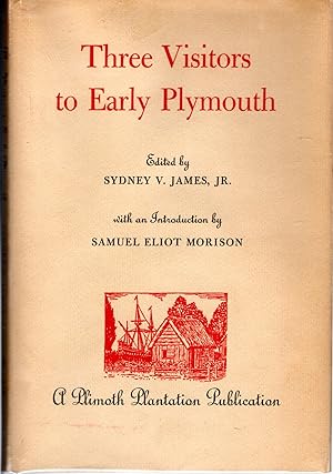
Three Visitors to Early Plymouth: Letters about the Pilgrim Settlement in New England During its First Seven Years, by John Pory, Emmanuel Altham, and Isaack De Rasieres. Edited by Sydney V. James, Jr. , with an Introd. by Samuel Eliot Morison
Language: English
Published by Plymouth Plantation Publication, Plymouth, MA, 1963
Seller: Dorley House Books, Inc., Hagerstown, MD, U.S.A.
Seller rating 4 out of 5 stars

First Edition
Hardcover. Condition: Very Good. Dust Jacket Condition: Very Good. Map (illustrator). 1st. 1st printing; dj jw/lite age-toning, in mylar; green w/gilt spoine titles; 84 clean, unmarked pages.
-

Hardcover. Condition: Fine. JACQUELINE CLARK (MAP ILLUSTRATIONS) (illustrator). 304 Pp. COPYRIGHT 1939. BOOK DESCRIPTION: MARIGOLD CLOTH HARDBOUND, BLACK STAMPED TITLE/DESIGN ON SPINE COVER/FRONT COVER, ILLUSTRATED WITH BLACK/WHITE PHOTO IMAGES AND MAPS, MAP ILLUSTRATED BOARDS. DIMENSIONS: 8 3/16" x 5 3/4" x 1 1/4." BOOK CONDITION: FINE; OWNERSHIP BOOKPLATE ON FRONT BOARD.
-

PENNSYLVANIA Colony and Commonwealth
Published by Henry T. Coates and Company, Philadelphia, PA, 1897
Seller: Riverow Bookshop, Owego, NY, U.S.A.
Seller rating 5 out of 5 stars

Cloth. Condition: G/No Dustjacket. Fold-Out Map (illustrator). Philadelphia, PA: Henry T. Coates and Company. G/No Dustjacket. 1897. . Cloth. untrimmed page edges . 8vo., 442 pp., rubbed, bumped, faded, page yellowing, writing on ffe .
-
Hard Covers. Condition: VG. No Jacket. Photos, Art, Map (illustrator). 1st. Shortly before the outbreak of WWII Sydney Waters compiled a history of the New Zealand Shipping Company "Clipper Ship to Moror Liner." His second book for the company, and the associate Federal Steam Navigation Co, carries that story on through the difficult, dangerous and costly time of the 1939-45 war. Of the fine ships of the two companies, 19 were lost to enemy action, totalling almost 200,000 gross register tons. This was more than half the total tonnage at the outbreak of war, Four other ships (26,253 grt) operated for the Ministry of War Transport were also lost. First company ship sunk was the Turakina, victim of the German raider Orion in the Tasman Sea in August 1940, after a gallant but one-sided fight. The price in lives lost throughout the war was was 279 masters, officers and crew, including stewardesses. This account of the company's WWII operations meets the author's high standard of maritime writing in every way. 263 pages including five appendices and index, five b/w plates (four photos, one painting), one map. Red hard covers with gilt spine titles on black panel VG, light fading to both boards, corners lightly bumped, former owner stamp top left front pastedown, also lower margin p26, light foxing to FEPs, text block otherwise VG+.
-
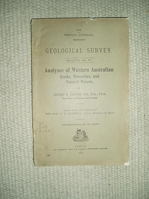
Analyses of Western Australian Rocks, Meteorites, and Natural Waters
Published by Fred. Wm. Simpson, Perth, 1916
Seller: Expatriate Bookshop of Denmark, Svendborg, Denmark
Seller rating 5 out of 5 stars
orig. wrappers. Folding map. (illustrator). 21x13cm, 197,(10) pp., Cover verso edge repaired with paper-tape. Series: Western Australia Geological Survey, Bulletin No. 67. Rubbed. Some spine and cover edge chips & tears. Just Good.
-
Saran [ Bihar and Orissa District Gazetteers ]
Published by Supt, Government Printing, Patna [Bihar], 1930
Seller: Expatriate Bookshop of Denmark, Svendborg, Denmark
Seller rating 5 out of 5 stars
orig.cloth. Folding map. (illustrator). 24x16cm, ii,177,x pp., Revised edition by Arthur Purling Middleton. Includes a folding map in rear pocket. Gazetteer for a western Bihar district [aka Chapra district]. Contents: Physical aspects; History; The people; Public health; Agriculture, natural calamities; rents, wages & prices; Occupations, manufactures and trades; Means of communication; Land revenue administration; General administration; Local self-government; Education; Gazetteer; Statistical tables Binding heavily stained and rubbed. Just Good.
-
Plan de la Ville de Sydney, Capitale des Colonies Anglaises aux Terres Australes. Lev� par Mr. Lesueur et assujetti aux relevemens de Mr. Boullanger, 9bre [Novembre] 1802
Published by 'Lev� par Lesueur., J. Milbert direx., Cloquet sculp.', [Paris, 1824
Seller: Michael Treloar Booksellers ANZAAB/ILAB, Adelaide, SA, Australia
Association Member: ANZAAB ILAB
Seller rating 5 out of 5 stars
Map
Condition: Very Good. [Paris, 'Lev� par Lesueur., J. Milbert direx., Cloquet sculp.', 1824]. An engraved map elaborately matted (obscuring the printer's imprint below the key and the plate number 17 in the top right-hand corner; visible image size 197 � 240 mm), framed and glazed (external dimensions 470 � 510 mm). A couple of very faint spots of foxing; in excellent condition. A handsomely-presented example of this early French map of Sydney, from the published account of the Baudin expedition of 1800-3. This version comes from the atlas to the second edition of 1824. It contains significantly more detail than the version found in the first edition of 1811, and is a more attractive presentation overall. In 'Framing New Holland or framing a narrative? A representation of Sydney according to Charles-Alexandre Lesueur' (Framing French Culture, 2015), Jean Fornasiero traces the development of this image, a hybrid produced from charts by the expedition's hydrographer, Charles Boullanger, and Lesueur's more impressionistic watercolour (he was, after all, the expedition's artist, and better known for his views and natural history plates).
-

North Sydney / Mosman.
Publication Date: 1925
Seller: Geographicus Rare Antique Maps, Brooklyn, NY, U.S.A.
Association Member: ABAA ESA ILAB
Seller rating 4 out of 5 stars
Map
Good. Wear and soiling along fold lines. Size 14.75 x 13 Inches. A curious two-sided c. 1925 map of Mosman and North Sydney, suburbs of Syndey, Australia. Together, the maps give a sense of the development of the Lower North Shore, which both necessitated and was further facilitated by the construction of the Syndey Harbour Bridge. A Closer Look One side of the map displays the suburb of Mosman, with roads, tramways, ferry lines, parks, military land, and other features (including the Taronga Zoological Park) noted. The reverse side includes a similar map of North Sydney, notable for the density of trams and the North Shore Line railway running through the suburb (in the late 19th century, Syndey was home to the second largest tram network in the British Empire / Commonwealth, after London). Also significant is the presence of the Syndey Harbour Bridge (here under construction and labelled as 'North Shore Bridge'), an impressive feat of engineering and one of Australia's most famous landmarks. Both maps are surrounded by letters forming a grid laid into a border, as well as advertisements, mostly relating to automobiles and real estate. Publication History and Census This map was produced by an unknown creator around the year 1925. Though undated, the labelling of the Syndey Harbour Bridge as 'under construction' indicates a date between 1923 and 1932, consistent with other features on the map. Notes that refer to other maps (for example, 'See Map City of Sydney') suggest that the present sheet was part of a larger series. We have been unable to locate any other examples of this map in institutional holdings or on the market.
-

The City of Sydney.
Publication Date: 1944
Seller: Geographicus Rare Antique Maps, Brooklyn, NY, U.S.A.
Association Member: ABAA ESA ILAB
Seller rating 4 out of 5 stars
Map
Good. Closed tear extending two inches into printed area from left margin professionally repaired on verso. Closed tear extending one half inch into printed area from right margoin professionally repaired on verso. Text on verso. Size 14.25 x 15.75 Inches. Created for Allied personnel during World War II, this 1944 David Jones city plan or map of Sydney, Australia highlights locations that would be most important to Allied personnel either stationed in the city, visiting on a weekend pass, or returning from combat. Depicting the city from Darling Harbor to Elizabeth Point and from Walsh Bay to Belmore Park and the central train station, thirty-nine locations are numerically identified. The first nine and last three, hostels and American Red Cross Clubs, are listed on the recto along the right border. The remaineder, of which two dozen are cinemas and theaters, are listed on the verso. Several sites around the city are illustrated in profile, including St. Mary's Cathedral, the general post office, and the central train station. Both Government House and the conservatorium are illustrated and labeled within the botanic gardens, which are shaded green, and the art gallery is highlighted in The Domain. Hyde Park and Belmore Park are also both identified and shaded. Verso content also includes short descriptions of places of interest in a near Sydney as well as short trips in the immediate vicinity and a map of Sydney's beaches. Publication History and Census This map was published by David Jones Limited in 1944. Several subsequent editions were published as late as the 1950s. This piece is rare, as we have only located one example in an institutional collection at the National Library of Australia and it rarely appears on the private market. References: National Library of Australia MAP G8974.S9E635 [1944].
-

Plan von Sydney der Hauptstadt der Englischen Colonien in Australien. Aufgenommen von Hrn. Lesueur; und berichtigt von Hrn Boullanger i. J. 1802.
Publication Date: 1815
Seller: Geographicus Rare Antique Maps, Brooklyn, NY, U.S.A.
Association Member: ABAA ESA ILAB
Seller rating 4 out of 5 stars
Map Signed
Very good. Minor wear along original fold lines. Slight loss in lower margin near edge of sheet. Size 7 x 9 Inches. One of the earliest obtainable maps of the city of Sydney, Australia, this is an 1815 German edition of an 1802 manuscript map by Charles-Alexandre Lesueur. A Closer Look The map covers from Darling Harbour to Dawes Batter and from Woolloomooloo to Brickfields. At the bottom of the plan, there is a numbered index that identifies 38 important buildings. In addition, the map notes roads, buildings, windmills, gardens, orchards, gallows (with unfortunate occupants), brick fields, and the cemetery. The manuscript on which this map is based survives in the collections of the Museum d'Histoire Naturelle in Le Havre, France. Lesueur accompanied the Napoleon-sponsored expedition of Nicolas Baudin, which sailed from Le Havre on October 19, 1800. Initially, he signed on as an assistant gunner, but his skills at drawing, mathematics, and scientific observation were promptly recognized, leading him to be reassigned as the ship's 'artist' and 'assistant naturalist.' Although Lesueur is commonly credited with the authorship of this map, he more likely simply assisted in the illustration of a map prepared by Charles Pierre Boullanger, a midshipman on the same vessel. In this example's title area, Boullanger is credited with 'correcting' the map, but we suspect this ghosts over deeper involvement. The French and English were in the midst of the Napoleonic Wars (1803 - 1815) at this time, and we can only imagine that the British must have felt considerable trepidation as their militarily sensitive harbor was mapped by a government-sponsored French expedition. Publication History and Census The map was first engraved by Jean Baptiste Antoine Cloquet and printed in the 1802 French edition of Francois Peron's Voyage de decouvertes aux terres Australes . The work proved popular, and subsequent French, English, and German editions followed. The present example is the 1815 German edition. It was published by Geographischen Institutes of Weimer and is one of that organization's earliest and most significant publications. References: Perry, T and Prescott, J. F., A Guide to Maps of Australia in Books Published 1780 - 1830, 1808.3. Bonnemains, J., Forsyth, E., Smith, B., Baudin in Australian Waters, 16074.3. McCormick, Tim, First Views of Australia, 1788- 1825: A history of early Sydney, no. 62. Signed by Author(s).
-

Australia East Coast Sheet IV Broken Bay to Sugarloaf Point.
Publication Date: 1861
Seller: Geographicus Rare Antique Maps, Brooklyn, NY, U.S.A.
Association Member: ABAA ESA ILAB
Seller rating 4 out of 5 stars
Map
Very good. Minor repairs upper right margin. Separate issue. Seller's stamp, right margin. Some pen marks related to navigational use. Size 19.5 x 26 Inches. This is an extremely rare 1862 map of eastern Australia covering from Sugarloaf Point to Broken Bay, just north of Syndey. This is one of the earliest large scale Nautical charts provide scientifically surveyed hydrographic detail for a significant portion of the Australian coast. It is the result of marine surveys completed by Commander John Lort Stokes and the HMS Acheron . Port Stephens and Broken Bay are, in particular, well mapped with numerous detailed soundings. Lights are identified at Newcastle Harbor and Port Stephens. This map was printed by John Walker for the British Admiralty Hydrographic Office as chart number 2144. The original seller for this chart appears to have been J. D. Potter, of King Street, Tower Hill, London. It subsequently found its way to Melbourne, Australia, where it was sold by Blundell and Ford, Agents for the sale of Admiralty Charts. This chart was originally published in 1852. Updated states were issued in 1860 and, as here, 1862. All examples of this chart in all editions are extremely rare. We have identified only four examples of this map in institutional collections. Two, an 1852 state and the present 1862 state, are housed in the National Library of Australia. Other examples of the 1852 state are housed at the Victoria State Library and at the National Library of Scotland. We are aware of no additional examples of the 1862 state. References: National Library of Australia, 3791297.
-

Australia East Coast Sheet III Jervis Bay to Broken Bay.
Publication Date: 1865
Seller: Geographicus Rare Antique Maps, Brooklyn, NY, U.S.A.
Association Member: ABAA ESA ILAB
Seller rating 4 out of 5 stars
Map
Very good. Minor repairs upper right margin. Separate issue. Seller's stamp, top margin. Some pen marks related to navigational use. Size 26 x 19.5 Inches. This is an extremely rare 1865 map of eastern Australia covering from Broken Bay to Jervis Bay, including Sydney Port Jackson, and Botany Bay. This is one of the earliest large scale Nautical charts provide scientifically surveyed hydrographic detail for a significant portion of the Australian coast. It is the result of marine surveys completed by Commander John Lort Stokes and the HMS Acheron . Broken Bay, Port Jackson, Botany Bay, and Jervis Bay are, in particular, well mapped with numerous detailed soundings. This map was printed by John Walker for the British Admiralty Hydrographic Office as chart number 2143. The original seller for this chart appears to have been J. D. Potter, of King Street, Tower Hill, London. It subsequently found its way to Melbourne, Australia, where it was sold by Blundell and Ford, Agents for the sale of Admiralty Charts. The chart was originally published in 1852. Updated states were issued in 1857, 1864, and, as here, 1865. All examples of this chart in all editions are extremely rare. We have identified only a single other example of this chart, in a different edition, housed in the National Library of Australia. We are aware of no other examples of the 1865 state. References: National Library of Australia 3791296. OCLC 662515766.

![Seller image for Plan de la Ville de Sydney, Capitale des Colonies Anglaises aux Terres Australes. Lev� par Mr. Lesueur et assujetti aux relevemens de Mr. Boullanger, 9bre [Novembre] 1802 for sale by Michael Treloar Booksellers ANZAAB/ILAB](https://pictures.abebooks.com/inventory/md/md30796710518.jpg)