
Order Total (1 Item Items):
Shipping Destination:

Map Walker John (3 results)
Skip to main search results
Search filters
Product Type
- All Product Types
- Books (3)
- Magazines & Periodicals (No further results match this refinement)
- Comics (No further results match this refinement)
- Sheet Music (No further results match this refinement)
- Art, Prints & Posters (No further results match this refinement)
- Photographs (No further results match this refinement)
- Maps (No further results match this refinement)
- Manuscripts & Paper Collectibles (No further results match this refinement)
Condition Learn more
- New (No further results match this refinement)
- As New, Fine or Near Fine (No further results match this refinement)
- Very Good or Good (No further results match this refinement)
- Fair or Poor (No further results match this refinement)
- As Described (3)
Binding
- All Bindings
- Hardcover (1)
- Softcover (No further results match this refinement)
Collectible Attributes
- First Edition (1)
- Signed (No further results match this refinement)
- Dust Jacket (No further results match this refinement)
- Seller-Supplied Images (3)
- Not Print on Demand (3)
Language (1)
Price
- Any Price
- Under US$ 25 (No further results match this refinement)
- US$ 25 to US$ 50 (No further results match this refinement)
- Over US$ 50
Free Shipping
- Free Shipping to U.S.A. (No further results match this refinement)
Seller Location
Seller Rating
-
Journal of the Royal Geographical Society , Volume II, 1832. [with maps 'South East portion of Australia during the progress of discovery in the interior of New South Wales to 1832' and 'Western Australia from the latest documents received 1832']
Published by John Murray for Royal Geographical Society, London, 1832
Seller: Muir Books [Robert Muir Old & Rare Books], PERTH, WA, Australia
Association Member: ANZAAB ILAB
Seller rating 5 out of 5 stars

First Edition
Leather. 1st Edition. 1st ed., Volume 2, octavo, full leather binding, gilt decoration to spine, gilt titled red leather spine label, maps, pp (viii), 334. Complete with all 11 maps. Some rubs and scrapes boards, trace of water damage corners of endpapers, foxing to first page of Nile report, also to maps of Africa and Egypt, light staining to margins (only) of New South Wales map. The map of Western Australia in near fine conditon. Amorial bookplate of J.T. Williamson. Very good condition. Maps include John Walker's large folding map of Western Australia whic accompanies Recent Information from Australia with a despatch from Lieut-Governor James Stirling describing the Swan River district, 2 April 1832, and Arrowsmith's large folding map of New South Wales to accompany Allan Cunningham's report of exploration of the interior. Also included: a letter from Captain FitzRoy regarding the Abrolhos Islands, and maps of North Africa, the Egyptian desert, British Guiana, the Maldives, the mouth of the Ganges river, New Zealand, the Virgin Islands, the Upper Nile, west Africa.
-
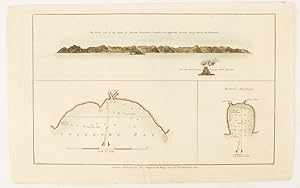
The North side of Queen Charlotte's Islands as it appeared running along shore to the Westward.
Published by Alexander Hogg at the King's Arms. [circa1784]., (London)., 1784
Seller: Asia Bookroom ANZAAB/ILAB, Canberra, ACT, Australia
Association Member: ANZAAB ILAB
Seller rating 5 out of 5 stars
Engraved map in triptych, on laid paper, 20.1 x 32.7 cm, three insets: cross section of the north side of Queen Charlotte's Islands (Solomon Islands) with detail of a volcano "6 leagues North"; Swallow's Bay Harbour; and Byron's Harbour, early hand colour, trimmed to the plate mark at the top edge, neat sealed tear affecting the publisher's caption, slight edge wear and paper toning, but a most attractive map in very good condition. Attractive engraving of the Queen Charlotte's Islands (Solomon Islands). The Islands were named for the consort of King George III, by Philip Carteret, the British naval officer and explorer who participated in two of the Royal Navy's circumnavigation expeditions in 1764?66 and 1766?69. His ship the Swallow gave her name to the Bay, and Carteret's commanding officer on the first of his voyages, John Byron, to the Harbour, depicted in this most attractive early chart.
-
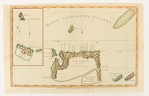
Queen Charlotte's Islands.
Published by Alexander Hogg at the King's Arms. [circa1784]., (London)., 1784
Seller: Asia Bookroom ANZAAB/ILAB, Canberra, ACT, Australia
Association Member: ANZAAB ILAB
Seller rating 5 out of 5 stars
Engraved map on laid paper, 21.4 x 33.7 cm, inset of Gower's, Simson's and Carteret's Island, early outline hand colour, trimmed to the plate mark at the top edge, three small edge tears affecting the upper margin only, slight paper toning, but a most attractive map in very good condition. Fine impression of the Queen Charlotte's Islands (Solomon Islands). It features the Swallow's track, the ship's route taken by Captain Philip Carteret in 1767, the British naval officer and explorer who participated in two of the Royal Navy's circumnavigation expeditions in 1764?66 and 1766?69.
![Seller image for Journal of the Royal Geographical Society , Volume II, 1832. [with maps 'South East portion of Australia during the progress of discovery in the interior of New South Wales to 1832' and 'Western Australia from the latest documents received 1832'] for sale by Muir Books [Robert Muir Old & Rare Books]](https://pictures.abebooks.com/inventory/md/md31886591989.jpg)