Map Weller Edward (13 results)

Language: English
Published by CASSELL, PETTER & GALPIN, London 1865
- First Edition
Seller: K Books Ltd ABA ILAB, York, YORKS, United KingdomK Books Ltd ABA ILAB
Contact seller5-star sellerCondition: Used - Very good
US$ 20.59
US$ 26.16 shippingShips from United Kingdom to U.S.A.Quantity: 1 available
Single Sheet. Condition: Very Good. No Jacket. First Edition. DEVON, AN ANTIQUE MAP, CIRCA 1865, AN ANTIQUE MAP, CIRCA 1865 MEASURES 25 X 16 INCHES, 63 X 43 CMS, GOOD CONDITION, WE PACK VERY WELL, TOO LARGE TO SEND MOUNTED SO DISPATCHED ROLLED IN A STRONG TUBE.SPLENDID VALUE --. Edward WELLER (illustrator).
Language: English
Published by CASSELL, PETTER & GALPIN, London 1865
- First Edition
Seller: K Books Ltd ABA ILAB, York, YORKS, United KingdomK Books Ltd ABA ILAB
Contact seller5-star sellerCondition: Used - Very good
US$ 27.50
US$ 26.16 shippingShips from United Kingdom to U.S.A.Quantity: 1 available
Single Sheet. Condition: Very Good. No Jacket. First Edition. NORTHER IRELAND, AN ANTIQUE MAP, CIRCA 1865 MEASURES 25 X 16 INCHES, 63 X 43 CMS, GOOD CONDITION, WE PACK VERY WELL, TOO LARGE TO SEND MOUNTED SO DISPATCHED ROLLED IN A STRONG TUBE.SPLENDID VALUE --. Edward WELLER (illustrator).
Language: English
Published by CASSELL, PETTER & GALPIN, London 1865
- First Edition
Seller: K Books Ltd ABA ILAB, York, YORKS, United KingdomK Books Ltd ABA ILAB
Contact seller5-star sellerCondition: Used - Very good
US$ 27.50
US$ 26.16 shippingShips from United Kingdom to U.S.A.Quantity: 1 available
Single Sheet. Condition: Very Good. No Jacket. First Edition. DORSET [DORCESTERSHIRE], AN ANTIQUE MAP, CIRCA 1865 , AN ANTIQUE MAP, CIRCA 1865 .AN ANTIQUE MAP, CIRCA 1865 MEASURES 25 X 16 INCHES, 63 X 43 CMS, GOOD CONDITION, WE PACK VERY WELL, TOO LARGE TO SEND MOUNTED SO DISPATCHED ROLLED IN A STRONG TUBE.SPLENDID VALUE --. Edw…ard WELLER (illustrator).
Language: English
Published by CASSELL. PETTER & GALPIN, London 1865
Seller: K Books Ltd ABA ILAB, York, YORKS, United KingdomK Books Ltd ABA ILAB
Contact seller5-star sellerCondition: Used - Very good
US$ 27.64
US$ 26.16 shippingShips from United Kingdom to U.S.A.Quantity: 1 available
No Binding. Condition: Very Good. A very detailed original antique map drawn by Edward Weller FRGS. no date of publication but with a lot of information about the county of Hereford and its population based on the 1861 census and with crime statistics dated 1862, coloured in outline, slight foxing at edges - impressive and reaso…nably priced. Edward WELLER (illustrator).
Language: English
Published by CASSELL. PETTER & GALPIN, London 1865
Seller: K Books Ltd ABA ILAB, York, YORKS, United KingdomK Books Ltd ABA ILAB
Contact seller5-star sellerCondition: Used - Very good
US$ 27.64
US$ 26.16 shippingShips from United Kingdom to U.S.A.Quantity: 1 available
No Binding. Condition: Very Good. A very detailed original antique map drawn by Edward Weller FRGS. no date of publication but with a lot of information about the county of Wiltshire and its population based on the 1861 census and with crime statistics dated 1862, coloured in outline, slight foxing at edges - impressive and reas…onably priced. Edward WELLER (illustrator).
Language: English
Published by CASSELL. PETTER & GALPIN, London 1865
Seller: K Books Ltd ABA ILAB, York, YORKS, United KingdomK Books Ltd ABA ILAB
Contact seller5-star sellerCondition: Used - Very good
US$ 27.64
US$ 26.16 shippingShips from United Kingdom to U.S.A.Quantity: 1 available
No Binding. Condition: Very Good. A very detailed original antique map drawn by Edward Weller FRGS. no date of publication but with a lot of information about the county of Monmouth and its population based on the 1861 census and with crime statistics dated 1863, coloured in outline, slight foxing at edges - impressive and reaso…nably priced. Edward WELLER (illustrator).
Language: English
Published by CASSELL. PETTER & GALPIN, London 1865
Seller: K Books Ltd ABA ILAB, York, YORKS, United KingdomK Books Ltd ABA ILAB
Contact seller5-star sellerCondition: Used - Very good
US$ 27.64
US$ 26.16 shippingShips from United Kingdom to U.S.A.Quantity: 1 available
No Binding. Condition: Very Good. A very detailed original antique map drawn by Edward Weller FRGS. no date of publication but with a lot of information about the county of "Edinburghshire" (now Midlothian) and for the Royal Burgh of Edinburgh and its population based on the 1861 census, coloured in outline, slight foxing at edg…es - impressive and reasonably priced. Edward WELLER (illustrator).
Language: English
Published by CASSELL. PETTER & GALPIN, London 1865
Seller: K Books Ltd ABA ILAB, York, YORKS, United KingdomK Books Ltd ABA ILAB
Contact seller5-star sellerCondition: Used - Very good
US$ 27.64
US$ 26.16 shippingShips from United Kingdom to U.S.A.Quantity: 1 available
No Binding. Condition: Very Good. A very detailed original antique map drawn by Edward Weller FRGS. no date of publication but with information about the MPs returned for the North Division of Hampshire, coloured in outline, slight foxing at edges - impressive and reasonably priced. Edward WELLER (illustrator).
Language: English
Published by CASSELL. PETTER & GALPIN, London 1865
Seller: K Books Ltd ABA ILAB, York, YORKS, United KingdomK Books Ltd ABA ILAB
Contact seller5-star sellerCondition: Used - Very good
US$ 34.55
US$ 26.16 shippingShips from United Kingdom to U.S.A.Quantity: 1 available
No Binding. Condition: Very Good. A very detailed original antique map drawn by Edward Weller FRGS, showing roads, railways, rivers, hills etc. no date of publication but with a lot of information about the counties of Worcestershire & Gloucestershire and their populations based on the 1861 census and with crime statistics dated… 1862, coloured in outline, slight foxing at edges, central fold - impressive and reasonably priced. Edward WELLER (illustrator).
Language: English
Published by CASSELL. PETTER & GALPIN, London 1865
Seller: K Books Ltd ABA ILAB, York, YORKS, United KingdomK Books Ltd ABA ILAB
Contact seller5-star sellerCondition: Used - Very good
US$ 34.55
US$ 26.16 shippingShips from United Kingdom to U.S.A.Quantity: 1 available
No Binding. Condition: Very Good. A very detailed original antique map drawn by Edward Weller FRGS, showing roads, railways, rivers, hills etc. no date of publication but with a lot of information about the county of Shropshire and its population based on the 1861 census and with crime statistics dated 1863, coloured in outline,… slight foxing at edges, central fold - impressive and reasonably priced. Edward WELLER (illustrator).
GREAT NORTHERN RAILWAY, Sheet 1, London to Grantham & Nottingham - an Original Antique Map, 1860
GREAT NORTHERN RAILWAY, Sheet 1, London to Grantham & Nottingham - an Original Antique Map, 1860
Language: English
Published by Weekly Dispatch, London 1860
Seller: K Books Ltd ABA ILAB, York, YORKS, United KingdomK Books Ltd ABA ILAB
Contact seller5-star sellerCondition: Used - Very good
US$ 55.27
US$ 26.16 shippingShips from United Kingdom to U.S.A.Quantity: 1 available
No Binding. Condition: Very Good. An original antique map, mounted (matted) and ready to frame. No date of publication but c1860. The route of the Great Northern Railway is shown in 4 strips arranged side-by-side with counties coloured in outline. Other railway routes are shown as they join the Great Northern. Some fraying to co…rners, otherwise good. Edward WELLER (illustrator).
Published by William Collins, Sons & Co. [circa1870s]., London & Glasgow. 1870
Seller: Asia Bookroom ANZAAB/ILAB, Canberra, ACT, AustraliaAsia Bookroom ANZAAB/ILAB
Contact seller5-star sellerCondition: Used
US$ 32.78
US$ 21.25 shippingShips from Australia to U.S.A.Quantity: 1 available
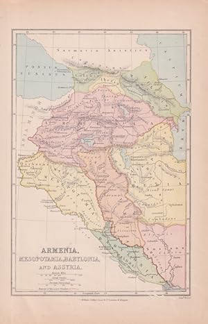
Map of ancient Armenia and Mesopotamia, printed in colour with the Retreat of the Ten Thousand during the final years of the Peloponnesian War picked out in original hand colour, 14.9 x 21.9 cm, paper toned at the edges, small silverfish abrasions affecting the bottom grid and margin, but in very good condition. Text in Latin.

Published by Weekly Dispatch Atlas. [circa1860]., London. 1860
Seller: Asia Bookroom ANZAAB/ILAB, Canberra, ACT, AustraliaAsia Bookroom ANZAAB/ILAB
Contact seller5-star sellerCondition: Used
US$ 91.05
US$ 21.25 shippingShips from Australia to U.S.A.Quantity: 1 available
Map with outline handcolour, 31.3 x 43.3; 33.3 x 48.7 cms (sheet), 12 x 17 inches, small marginal bloom, not affecting the map, in very good condition. Detailed mapping of these two island groups by Edward Weller (1819?1884), from the ??Weekly Dispatch Atlas?, an atlas published in monthly instalments from 1855 for subscribers t…o the long running newspaper. Weller was a pioneer in lithography and was sought after for his skill in producing detailed and accurate maps.

