
Order Total (1 Item Items):
Shipping Destination:

Mercator Michael (3 results)
Skip to main search results
Search filters
Product Type
- All Product Types
- Books (3)
- Magazines & Periodicals (No further results match this refinement)
- Comics (No further results match this refinement)
- Sheet Music (No further results match this refinement)
- Art, Prints & Posters (No further results match this refinement)
- Photographs (No further results match this refinement)
- Maps (No further results match this refinement)
- Manuscripts & Paper Collectibles (No further results match this refinement)
Condition Learn more
- New (No further results match this refinement)
- As New, Fine or Near Fine (No further results match this refinement)
- Very Good or Good (No further results match this refinement)
- Fair or Poor (No further results match this refinement)
- As Described (3)
Binding
- All Bindings
- Hardcover (No further results match this refinement)
- Softcover (No further results match this refinement)
Collectible Attributes
- First Edition (No further results match this refinement)
- Signed (No further results match this refinement)
- Dust Jacket (No further results match this refinement)
- Seller-Supplied Images (2)
- Not Print on Demand (3)
Language (1)
Price
- Any Price
- Under US$ 25 (No further results match this refinement)
- US$ 25 to US$ 50 (No further results match this refinement)
- Over US$ 50
Free Shipping
Seller Location
Seller Rating
-

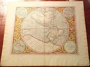
America sive India Nova.
Published by Amsterdam, Jodocus Hondius, 1609, French text edition. 375 x 470mm (14� x 18� inches)., 1609
Seller: Tooley, Adams & Co., Wallingford, OXON, United Kingdom
Seller rating 3 out of 5 stars

US$ 5,247.65
US$ 49.81 shipping
Ships from United Kingdom to U.S.A.Quantity: 1 available
Add to basketFinely hand coloured; excellent condition over all with only very minor age-toning to the margins The only known map engraved by Gerard Mercator's grandson (better known for his engraving of the Drake silver medal while resident in London in 1589). First published in Duisburg, 1595, it shows North and South America within a sphere, with a large New Guinea and "Terra Australis Nondum Cognita". A clear North-West Passage is shown; the St Lawrence river runs past the unknown Great Lakes to rise in a mountain chain mid-continent; the mythical "Friesland" is shown near Iceland; South America has a distinctive bulge in the south-west (removed from Ortelius' map 1587), and at the North Pole is the island invented for magnetic north. Around the map is an extensive floral pattern with roundels in each corner, one for the title, the others for inset maps of the Gulf of Mexico, Cuba and Haiti. BURDEN: 87. KOEMAN: Me 19.
-

America Sive India Nova.
Published by Amsterdam: Hondius, c 1607., 1607
Seller: Arader Galleries - AraderNYC, New York, NY, U.S.A.
Seller rating 5 out of 5 stars

Single sheet (17 � x 21 inches sheet; 26 � x 30 � inches framed; full margins showing the plate mark). Fine engraved single hemisphere map of the world surrounded by four inset roundels of Cuba, Haiti, the Gulf of Mexico, and the imprint, all within an elaborate border of cornucopia and acanthus leaves, and with original hand-colour in full. First published in 1595 in Gerard and Rumold Mercator's celebrated "Atlantis Pars Altera", this is the first map to show the Great Lakes of Northern America. With New Guinea in the east, and Terra Australis as a great southern land mass. The Mercator family of cartographers produced some of the most important maps of the sixteenth century of which the present map is but one. Gerard Mercator, the patriarch of the family, is famed for the development of Mercator's projection, first demonstrated on his world map of 1569, which allowed any compass course to appear as a straight line. His next project was the creation of a complete world 'Atlas', the first publication to be called by that name. This occupied him until his death in 1594 and the unfinished atlas was left in the care of his son, Rumold. The task of the American map, America sive India Nova., was given to Gerard's grandson Michael and it is the only known map published by him. The map represents a remarkable achievement for both its aesthetic beauty and relative accuracy. In cartographical terms, America was only sixty years old and the information available to Michael Mercator was at best limited. The general outline was taken from Rumold Mercator's world map of 1587. California is correctly shown as a peninsula, and the "Mare dulcium aquarum" probably reflects the first hints of the Great Lakes. Francisco L�pez de G�mara described the discovery of the West Indies as "the greatest event since the Creation of the World, excepting the Incamation and Death of Him who created it," in his 1552 dedication to Charles V of his Historia de las Indias, which perhaps explains the inclusion of small roundels depicting Cuba, Haiti, the Gulf of Mexico. These beautiful insets surround the map and rest amongst an ornate Mannerist decoration cornucopias and acanthus leaves. The present map is from the Jodocus Hondius edition of 1607. In 1606, Hondius purchased the copper plates from the Mercator family and reissued the atlas from Amsterdam. His sons, Jodocus II and Henricus continued with the publication of the maps until 1629 when a large number of the plates were sold to Willem Janszoon Blaeu. For more information on this map, or a warm welcome to see other maps and books of our collection at 72nd Street NYC, please contact Natalie Zadrozna.
-
America Sive India Nova.
Published by Amsterdam: Jodocus Hondius, 1633, 1633
Seller: Arader Galleries - AraderNYC, New York, NY, U.S.A.
Seller rating 5 out of 5 stars
MERCATOR, Michael (c. 1567-1614). America Sive India Nova. Amsterdam: Jodocus Hondius, 1633 Single sheet, float mounted and framed (19 x 22 6/8 inches; full margins showing the plate mark). French text on verso. Fine engraved single hemisphere map of the world surrounded by four inset roundels of Cuba, Haiti, the Gulf of Mexico, and the imprint, all within an elaborate border of cornucopia and acanthus leaves, and with original hand-colour in full. First published in 1595 in Gerard and Rumold Mercator's celebrated "Atlantis Pars Altera", this is the first map to show the Great Lakes of Northern America. With New Guinea in the east, and Terra Australis as a great southern land mass. The Mercator family of cartographers produced some of the most important maps of the sixteenth century of which the present map is but one. Gerard Mercator, the patriarch of the family, is famed for the development of Mercator's projection, first demonstrated on his world map of 1569, which allowed any compass course to appear as a straight line. His next project was the creation of a complete world 'Atlas', the first publication to be called by that name. This occupied him until his death in 1594 and the unfinished atlas was left in the care of his son Rumold. The task of the American map, America sive India Nova., was given to Gerard's grandson Michael and it is the only known map published by him. The map represents a remarkable achievement for both its aesthetic beauty and relative accuracy. In cartographical terms, America was only sixty years old and the information available to Michael Mercator was at best limited. The general outline was taken from Rumold Mercator's world map of 1587. California is correctly shown as a peninsula, and the "Mare dulcium aquarum" probably reflects the first hints of the Great Lakes. Francisco L�pez de G�mara described the discovery of the West Indies as "the greatest event since the Creation of the World, excepting the Incamation and Death of Him who created it," in his 1552 dedication to Charles V of his Historia de las Indias, which perhaps explains the inclusion of small roundels depicting Cuba, Haiti, the Gulf of Mexico. These beautiful insets surround the map and rest amongst an ornate Mannerist decoration cornucopias and acanthus leaves. The present map is from the Hondius edition of 1633. In 1606 Jodocus Hondius purchased the copper plates from the Mercator family and reissued the atlas from Amsterdam. His sons, Jodocus II and Henricus continued with the publication of the maps until 1629 when a large number of the plates were sold to Willem Janszoon Blaeu.
