Mitchell Samuel Augustus Sr (24 results)

Published by S. Augustus Mitchell, Philadelphia 1852
Seller: Argosy Book Store, ABAA, ILAB, New York, NY, U.S.A.Argosy Book Store, ABAA, ILAB
Contact seller5-star sellerunbound. Map. Lithograph with hand coloring. Sheet measures 11 1/2" x 18". Map displaying the southeastern United States including Arkansas, Louisiana, Mississippi, Alabama, Tennessee, North Carolina, South Carolina, Florida, and Georgia. Towns, railroads, canals, battle sites, and more are noted. A wonderfully detailed and clea…r map with flags noting remarkable battles. In very good condition with some surface dirt and minimal toning. Samuel Augustus Mitchell Sr. (1792-1868) was one of the leaders in American cartography of the 19th century and pioneered the conversion of engraved map plates to more affordable lithographic plates. His son, Samuel Augustus Mitchell Jr. continued his father's successful mapmaking and publishing business, and was one of the most prolific and renowned 19th century American publishers. Williams (illustrator).

Published by Philadelphia 1884
Seller: Argosy Book Store, ABAA, ILAB, New York, NY, U.S.A.Argosy Book Store, ABAA, ILAB
Contact seller5-star sellerunbound. Map. Engraving with original hand coloring. 14 1/4 x 11 1/2 inches. Early map of Palestine or the Holy Land from the Dead Sea to Lebanon with part of Syria showing the biblical names of the tribes of Israel. Royal cities noted with towns, waterways, and geographical features also labeled. Turkish names noted as well as…ruins. An inset of modern Jerusalem is included. In the index a color line should denote 'Land of the Philistines' but it was not colored in. In very excellent condition. Samuel Augustus Mitchell Sr. (1792-1868) was one of the leaders in American cartography of the 19th century and pioneered the conversion of engraved map plates to more affordable lithographic plates. His son, Samuel Augustus Mitchell Jr. continued his father's successful mapmaking and publishing business, and was one of the most prolific and renowned 19th century American publishers.

Published by Mitchell, Samuel Augustus, Philadelphia 1850
Seller: Argosy Book Store, ABAA, ILAB, New York, NY, U.S.A.Argosy Book Store, ABAA, ILAB
Contact seller5-star sellerCondition: Used - Very good
US$ 125.00
US$ 6.00 shippingShips within U.S.A.Quantity: 1 available
unbound. Condition: very good(+). Map. Engraving and lithograph with original hand coloring. Image measures 15" x 12". Classic map of New Hampshire and Vermont divided into counties. Details towns, major routes, railroad, waterways and topography. A table at right lists populations of individual counties and towns. Small chip to… lower right corner. Samuel Augustus Mitchell Sr. (1792-1868) was one of the leaders in American cartography of the 19th century and pioneered the conversion of engraved map plates to more affordable lithographic plates. His son, Samuel Augustus Mitchell Jr. continued his father's successful mapmaking and publishing business, and was one of the most prolific and renowned 19th century American publishers.

Published by S.A. Mitchell, Philadelphia 1848
Seller: Argosy Book Store, ABAA, ILAB, New York, NY, U.S.A.Argosy Book Store, ABAA, ILAB
Contact seller5-star sellerunbound. Map. Engraving with hand coloring. Image measures 11 1/8" x 14 1/4" Beautiful map of Maryland and Delaware divided into counties and townships. Shows towns, waterways, major routes and geographic features. Includes an inset showing the city plan of Baltimore, with important buildings and points of interest listed and nu…mbered. A table in the upper left shows steam boat routes from Baltimore to Norfolk, Baltimore to Philadelphia, and Baltimore to Washington. Samuel Augustus Mitchell Sr. (1792-1868) was one of the leaders in American cartography of the 19th century and pioneered the conversion of engraved map plates to more affordable lithographic plates. His son, Samuel Augustus Mitchell Jr. continued his father's successful mapmaking and publishing business, and was one of the most prolific and renowned 19th century American publishers. H.N. Burroughs (illustrator).
Published by Thomas, Cowperthwait & Co, Philadelphia 1850
Seller: Argosy Book Store, ABAA, ILAB, New York, NY, U.S.A.Argosy Book Store, ABAA, ILAB
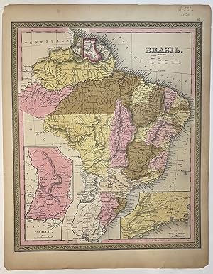
Contact seller5-star sellerunbound. Map. Lithograph with original hand coloring. Image measures 11 7/8" x 14 7/8". A beautiful map of Brazil, from 1850 including Uruguay, Paraguay, and Guiana. Hand colored to show provinces, and relief is shown by hachure. Rivers and cities are labeled. Features two insets, one of Paraguay, and the other showing Environs…of Rio Janiero. Both insets also show major roads. Overall, this is an excellent copy of this map, with slight toning to margins, not affecting the image. Published in the 1850 Cowperthwait edition of Mitchell's seminal "New Universal Atlas". Samuel Augustus Mitchell Sr. (1792-1868) is one of the leaders in American cartography of the 19th century and pioneered the conversion of engraved map plates to more affordable lithographic plates. His son, Samuel Augustus Mitchell Jr. continued his father's successful mapmaking and publishing business, and was one of the most prolific and renowned 19th century American publishers.

Published by S. A. Mitchell, Philadelphia 1846
Seller: Argosy Book Store, ABAA, ILAB, New York, NY, U.S.A.Argosy Book Store, ABAA, ILAB
Contact seller5-star sellerunbound. First. Map. Lithograph with original hand coloring. Image measures 14 7/8" x 12". Excellent map of Maine showing all counties, railroads, major routes and waterways. Two tables at the top of the page list population over time. Small chips to lower margin not affecting the image. From the first edition of Mitchell's semi…nal New Universal Atlas. This copy is State X-A of this map (Thompson 80) Samuel Augustus Mitchell Sr. (1792-1868) was one of the leaders in American cartography of the 19th century and pioneered the conversion of engraved map plates to more affordable lithographic plates. His son, Samuel Augustus Mitchell Jr. continued his father's successful mapmaking and publishing business, and was one of the most prolific and renowned 19th century American publishers.

Published by H. N. Burroughs, Philadelphia 1846
Seller: Argosy Book Store, ABAA, ILAB, New York, NY, U.S.A.Argosy Book Store, ABAA, ILAB
Contact seller5-star sellerunbound. Map. Lithograph with original hand coloring. Image measures 14 3/8" x 11 7/16". Classic map of Indiana divided into counties. The map includes towns and roads, in addition to canals, drawn in blue, and railroads, drawn in red. A table in the upper left shows steamboat routes from Louisville to Pittsburgh and to New Orle…ans. An elevation view on the right shows a profile of the Wabash and Erie Canal. The map is in good condition, with only minor chips and tears to edges, not affecting the image. Samuel Augustus Mitchell Sr. (1792-1868) published this map as part of the first edition of his seminal New Universal Atlas. Mitchell is one of the pioneers in American cartography of the 19th century and led the conversion of engraved map plates to more affordable lithographic plates.

Published by S. Augustus Mitchell, Philadelphia 1848
Seller: Argosy Book Store, ABAA, ILAB, New York, NY, U.S.A.Argosy Book Store, ABAA, ILAB
Contact seller5-star sellerunbound. Map. Lithograph with original hand coloring. Image measures 11.5 x 14.5 inches. This map depicts the state of Pennsylvania divided into counties. The map includes towns and roads, in addition to canals, colored in blue, and railroads, colored in red. An elevation view near the top margin shows the profile of the Pennsyl…vania Canal and the Columbia Railroad. A table in the lower left lists steam boat routes from Pittsburgh to Louisville, from Philadelphia to New York, and Philadelphia to Baltimore. The map appeared in Mitchell's seminal New Universal Atlas. The map is in very good condition. One small closed tear to upper left margin, not affecting the image. Archival tape repair. Samuel Augustus Mitchell Sr. (1792-1868) is one of the pioneers in American cartography of the 19th century and led the conversion of engraved map plates to more affordable lithographic plates.

Published by S. Augustus Mitchell, Philadelphia 1848
Seller: Argosy Book Store, ABAA, ILAB, New York, NY, U.S.A.Argosy Book Store, ABAA, ILAB
Contact seller5-star sellerunbound. Map. Lithograph with original hand coloring. Image measures 11 1/4" x 14". Beautifully detailed first edition map of South Carolina divided into counties. The map delineates towns, waterways, railroads, and major routes, as explained in a small key at the bottom right. Canals and railroads are marked. Also included are…insets of Charleston and a table of distances. The map is in good condition, with minor toning. Samuel Augustus Mitchell Sr. (1792-1868) published this map as part of the 1848 edition of his seminal New Universal Atlas. Mitchell is one of the pioneers in American cartography of the 19th century and led the conversion of engraved map plates to more affordable lithographic plates.

Published by S. Augustus Mitchell, Philadelphia 1846
Seller: Argosy Book Store, ABAA, ILAB, New York, NY, U.S.A.Argosy Book Store, ABAA, ILAB
Contact seller5-star sellerunbound. Map. Engraving with original hand coloring. Philadelphia: H.N. Burroughs, 1846. Image measures 12 1/4" x 14 3/4". First edition map of Connecticut divided into counties showing railroads, major routes and notable buildings. A statistical table lists population in various towns, counties and eras. Insets of Hartford and…New Haven. Canals are delineated by hand in blue, and railroads in orange. Toning and minor chips to margins, not affecting the image. Samuel Augustus Mitchell Sr. (1792-1868) published this map as part of the first edition of his seminal New Universal Atlas. Mitchell is one of the pioneers in American cartography of the 19th century and led the conversion of engraved map plates to more affordable lithographic plates.

Published by S. A. Mitchell, Philadelphia 1847
Seller: Argosy Book Store, ABAA, ILAB, New York, NY, U.S.A.Argosy Book Store, ABAA, ILAB
Contact seller5-star sellerunbound. Map. Lithograph with original hand coloring. Image measures 14 7/8" x 12". Excellent map of Maine showing all counties, railroads, major routes and waterways. Two tables at the top of the page list population over time. Small chips to lower margin not affecting the image. From the 1847 edition of Mitchell's seminal New…Universal Atlas. This is State XII of this map (Thompson 84). Samuel Augustus Mitchell Sr. (1792-1868) was one of the leaders in American cartography of the 19th century and pioneered the conversion of engraved map plates to more affordable lithographic plates. His son, Samuel Augustus Mitchell Jr. continued his father's successful mapmaking and publishing business, and was one of the most prolific and renowned 19th century American publishers.

Published by S. Augustus Mitchell, Philadelphia 1848
Seller: Argosy Book Store, ABAA, ILAB, New York, NY, U.S.A.Argosy Book Store, ABAA, ILAB
Contact seller5-star sellerunbound. Map. Lithograph with original hand coloring. Image measures 11 1/2" x 14 1/4" Beautifully detailed first edition map of Mississippi divided into counties. The map delineates towns, waterways, railroads, and major routes. Steamboat routes and distances are listed in a table. Canals and railroads are indicated. In very go…od condition, with some toning to margins. Samuel Augustus Mitchell Sr. (1792-1868) published this map as part of the 1848 edition of his seminal New Universal Atlas. Mitchell is one of the pioneers in American cartography of the 19th century and led the conversion of engraved map plates to more affordable lithographic plates.
Published by S. Augustus Mitchell, Philadelphia 1877
Seller: Argosy Book Store, ABAA, ILAB, New York, NY, U.S.A.Argosy Book Store, ABAA, ILAB
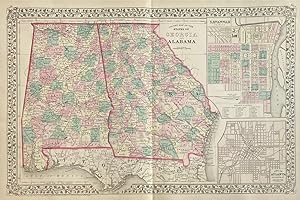
Contact seller5-star sellerunbound. Map. Lithograph with original hand coloring. Image measures 13 3/4" x 21 1/4" Interesting double-page map of Georgia and Alabama showing all counties, railroads, major routes and waterways. Two insets show town plans for the cities of Savannah, Georgia, and Atlanta, the capitol of Georgia. In excellent condition. One sm…all closed tear to left margin. Samuel Augustus Mitchell Sr. (1792-1868) is one of the leaders in American cartography of the 19th century and pioneered the conversion of engraved map plates to more affordable lithographic plates. His son, Samuel Augustus Mitchell Jr. continued his father's successful mapmaking and publishing business, and was one of the most prolific and renowned 19th century American publishers.

Published by H. N. Burroughs, Philadelphia 1846
Seller: Argosy Book Store, ABAA, ILAB, New York, NY, U.S.A.Argosy Book Store, ABAA, ILAB
Contact seller5-star sellerunbound. First. Map. Lithograph with original hand coloring. Image measures 15.75" x 12.5". This map of England shows capitals, cities, towns, railroads and canals. Counties are hand-colored and labeled with text fit into their individual shapes, giving the map a somewhat idiosyncratic look. At the top of the map, a small bit of… Scotland appears, uncolored, with Edinburgh labeled in the map's pink border. The Scottish city is flanked on either side by insets showing the environs of Liverpool, at left, and London, at right. A small inset in the lower left of the map depicts the Scilly Isles. The map appeared in Mitchell's first edition of his seminal New Universal Atlas. It in good condition with very minimal chips or tears. Browned margins. Samuel Augustus Mitchell Sr. (1792-1868) is one of the pioneers in American cartography of the 19th century and led the conversion of engraved map plates to more affordable lithographic plates. This map provides a condensed yet comprehensive view of mid-19th century England.

Published by H. N. Burroughs, Philadelphia 1847
Seller: Argosy Book Store, ABAA, ILAB, New York, NY, U.S.A.Argosy Book Store, ABAA, ILAB
Contact seller5-star sellerunbound. Map. Steel engraving. Image measures 20" x 16 3/8". This descriptive map of Palestine shows the political divisions of the region around 1846, when the region was under Turkish control. 38 Turkish Provinces are listed and 4 Pashaliks, or subdivisions, are shown: Tripoli, Damascus, Acre, and Gaza. Cities, rivers, roads,…and topographical features are all meticulously rendered for full accuracy. Many cities are also labeled with both English and Turkish names. Explanation of Arabic 10 appellatives. Inset of Jerusalem upper left. The map is in very good condition. Border of map and regions are hand colored. Samuel Augustus Mitchell Sr. (1792-1868) was one of the leaders in American cartography of the 19th century and pioneered the conversion of engraved map plates to more affordable lithographic plates. His son, Samuel Augustus Mitchell Jr. continued his father's successful mapmaking and publishing business, and was one of the most prolific and renowned 19th century American publishers.

Published by S. Augustus Mitchell, Philadelphia 1849
Seller: Argosy Book Store, ABAA, ILAB, New York, NY, U.S.A.Argosy Book Store, ABAA, ILAB
Contact seller5-star sellerunbound. Map. Engraving with original hand coloring. Philadelphia: H.N. Burroughs, 1846. Image measures 13 3/4" x 16". Very early map of Iowa, with the majority of the state still comprised of Native American territory. Rivers are labeled throughout. The southeast portion of the state is divided by counties, showing cities, town…s, railroads, and major routes. Many new American settlements remain nameless, labeled only as "C.H." to indicate a Court House, or county seat. Some indigenous villages are indicated. The northern and western parts of the state lack detail, and seem to be inhabited by the Pottawatomies and Sioux Indians. There is foxing throughout the sheet and minor staining. Samuel Augustus Mitchell Sr. (1792-1868) published this map as part of the first edition of his seminal New Universal Atlas. Mitchell is one of the pioneers in American cartography of the 19th century and led the conversion of engraved map plates to more affordable lithographic plates.

Published by S. Augustus Mitchell, Philadelphia 1847
Seller: Argosy Book Store, ABAA, ILAB, New York, NY, U.S.A.Argosy Book Store, ABAA, ILAB
Contact seller5-star sellerunbound. Map. Engraving with original hand coloring. Image measures 11 1/4" x 15 1/4". Nice map of Tennessee divided into counties. Features cities, major routes, canals, railroads, waterways and topographical elements. Insets include the environs of Knoxville and Nashville. A table lists steam boat routes. Minor overall toning.… Samuel Augustus Mitchell Sr. (1792-1868) was one of the leaders in American cartography of the 19th century and pioneered the conversion of engraved map plates to more affordable lithographic plates. His son, Samuel Augustus Mitchell Jr. continued his father's successful mapmaking and publishing business, and was one of the most prolific and renowned 19th century American publishers.
Published by H. N. Burroughs, Philadelphia 1846
Seller: Argosy Book Store, ABAA, ILAB, New York, NY, U.S.A.Argosy Book Store, ABAA, ILAB
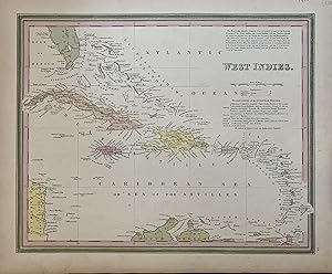
Contact seller5-star sellerunbound. Map. Lithograph with original hand coloring. Image measures 15.75" x 12.5". This map of the West Indies extends from the southern tip of Florida to the northern coast of South America, and from the western tip of Cuba to Barbados in the east. The index includes capitals, cities, and towns, labeled in a stylized manner t…hat complements the region's scattered arrangement of islands. Above the title is a paragraph describing the region and its constituent islands. Below the title, islands are attributed to the appropriate European colonial powers. The map appeared in Mitchell's first edition of his seminal New Universal Atlas. This map provides a clear overview of the West Indies. Samuel Augustus Mitchell Sr. (1792-1868) was one of the leaders in American cartography of the 19th century and pioneered the conversion of engraved map plates to more affordable lithographic plates. His son, Samuel Augustus Mitchell Jr. continued his father's successful mapmaking and publishing business, and was one of the most prolific and renowned 19th century American publishers.

Published by H. N. Burroughs, Philadelphia 1846
Seller: Argosy Book Store, ABAA, ILAB, New York, NY, U.S.A.Argosy Book Store, ABAA, ILAB
Contact seller5-star sellerunbound. First. Map. Lithograph with original hand coloring. Image measures 14 3/8" x 11 7/16". Wonderfully graphic and colorful map of Michigan amidst four Great Lakes. The map includes towns and roads, in addition to canals, drawn in blue, and railroads, drawn in orange. A small inset on the left depicts the western part of th…e state. Beneath the title, two tables list steam boat routes from Detroit to Fort Gratiot and Fort Howard. The map is in good condition, with only minor chips along the binding edge of the paper, outside the margin. This map was published in 1846 as part of the first edition of Mitchell's seminal New Universal Atlas. Samuel Augustus Mitchell Sr. (1792-1868) was one of the leaders in American cartography of the 19th century and pioneered the conversion of engraved map plates to more affordable lithographic plates. His son, Samuel Augustus Mitchell Jr. continued his father's successful mapmaking and publishing business, and was one of the most prolific and renowned 19th century American publishers. Mitchell is one of the pioneers in American cartography of the 19th century and led the conversion of engraved map plates to more affordable lithographic plates. First edition if this classic map.
Published by S. Augustus Mitchell, Philadelphia 1846
Seller: Argosy Book Store, ABAA, ILAB, New York, NY, U.S.A.Argosy Book Store, ABAA, ILAB
Contact seller5-star sellerCondition: Used - Very good
US$ 300.00
US$ 6.00 shippingShips within U.S.A.Quantity: 1 available
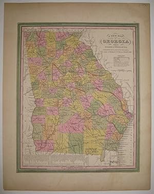
unbound. Condition: very good(+). Map. Lithograph with original hand coloring. Image measures 13 7/8" x 11 3/8". Great map of Georgia showing all counties, railroads, major routes and waterways. A table at the bottom of the page lists steam boat routes. Minor overall toning, one small tear to bottom edge and a crease to upper le…ft corner. Samuel Augustus Mitchell Sr. (1792-1868) was one of the leaders in American cartography of the 19th century and pioneered the conversion of engraved map plates to more affordable lithographic plates. His son, Samuel Augustus Mitchell Jr. continued his father's successful mapmaking and publishing business, and was one of the most prolific and renowned 19th century American publishers.

Published by S. Augustus Mitchell, Philadelphia 1839
Seller: Argosy Book Store, ABAA, ILAB, New York, NY, U.S.A.Argosy Book Store, ABAA, ILAB
Contact seller5-star sellerunbound. Map. Engraving with original hand coloring. Image measures 15.25" x 12.75". 16mo brown leather case with title and border embossed in gold. This is a scarce 1839 pocket map depicting the state of Illinois, with parts of Wisconsin, Missouri, Kentucky, and Indiana, during a time when the American Midwest was rapidly growi…ng. The map also features an inset showing the Lead Mine Region in the Wisconsin Territory (before Wisconsin became a state) and Illinois, a Population Chart according to the 1830 Census, and a chart of steam boat routes. Color coded by counties, the map details roads, railroads, canals, rivers, and a host of other topographical features. Vibrant and varied, the coloring of this map renders a cheerful and exciting visual effect that has withstood the test of time. The map was created by J. H. Young, published by S. A. Mitchell, and sold by Thomas, Cowperthwait & co. In good condition with some toning and minor tears along original fold lines. Folds into original binder. Samuel Augustus Mitchell Sr. (1792-1868) is one of the leaders in American cartography of the 19th century and pioneered the conversion of engraved map plates to more affordable lithographic plates. His son, Samuel Augustus Mitchell Jr. continued his father's successful mapmaking and publishing business, and was one of the most prolific and renowned 19th century American publishers. YOUNG, J. H. (illustrator).

Published by S. Augustus Mitchell, Philadelphia 1831
Seller: Argosy Book Store, ABAA, ILAB, New York, NY, U.S.A.Argosy Book Store, ABAA, ILAB
Contact seller5-star sellerunbound. Map. Engraving with original hand coloring. Image measures 21.5" x 16.75". 16mo brown leather case with title and border embossed in gold. This is a scarce 1831 pocket map depicting the states of Ohio, Indiana, Illinois, during a time when the American Midwest was rapidly growing. Michigan and Wisconsin are still territ…ories. Missouri and Missouri Territory, are noted, including the lands of the Sioux and Iaway (Ioway) Indians. Color coded by counties, the map details roads, railroads, canals, rivers, and a host of other topographical features. The map was published by S. A. Mitchell in 1831. In good condition with some toning and minor verso repairs along original fold lines. Folds into original binder. Samuel Augustus Mitchell Sr. (1792-1868) is one of the leaders in American cartography of the 19th century and pioneered the conversion of engraved map plates to more affordable lithographic plates. His son, Samuel Augustus Mitchell Jr. continued his father's successful mapmaking and publishing business, and was one of the most prolific and renowned 19th century American publishers.

Published by S. Augustus Mitchell, Philadelphia 1842
Seller: Argosy Book Store, ABAA, ILAB, New York, NY, U.S.A.Argosy Book Store, ABAA, ILAB
Contact seller5-star sellerunbound. Map. Lithograph with original hand coloring. Sheet measures 25.5" x 34.75. This 1842 case map by Samuel Augustus Mitchell offers a wealth of information about the United States. The centre of the page includes statistical data from 1840 relating to population, manufacturing, canals, exports, railroads, agriculture, mini…ng, rivers, etc. This information is surrounded by 32 maps of major cities. Some of these include Cincinnati, Detroit, New York, Charleston, Washington, New Orleans, Hartford, and Richmond, among others. Each map is surrounded by an ornate border. This map is the pocket map version of a larger wall map. In good condition with some wear along the original folds. Some foxing and toning at places. Lined with Japanese tissue. Samuel Augustus Mitchell Sr. (1792-1868) is one of the pioneers in American cartography of the 19th century and led the conversion of engraved map plates to more affordable lithographic plates. Bold design and hard to find.
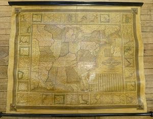
Published by S. Augustus Mitchell, Philadelphia 1844
Seller: Argosy Book Store, ABAA, ILAB, New York, NY, U.S.A.Argosy Book Store, ABAA, ILAB
Contact seller5-star sellerunbound. Map. Wall map on linen with wooden scrolls. 31.5" x 48.75" Large scale map of the eastern United States surrounded with insets of major harbors and towns. Elaborate border design with national coat of arms placed in the each corner contributes to its official quality. Population tables listed in three different insets p…lus an inset map of the Treaty of 1842, also called Webster-Ashburton Treaty settling a border dispute between Maine and New Brunswick. Large Iowa Territory and Minnesota is not yet named showing impending Westward expansion. From the "National Map Series" that Mitchell produced by subscription over a series of years. Original color but heavily varnished as issued. Samuel Augustus Mitchell Sr. (1792-1868) is one of the pioneers in American cartography of the 19th century and led the conversion of engraved map plates to more affordable lithographic plates. Drawn by James Henry Young (1817-1866) and engraved by J.H. Brightly, both collaborated with Mitchell on this series of maps.


