Moluccas (5 results)

Published by Berlin, F. Dümmler, 1884. (xii), 166pp. plus ills. on 3 plates, of which 1 coloured lithograph. Text in German. (Indonesien oder die Inseln des Malayischen Archipel. I.) 1884
- Softcover
Seller: Antiquariaat Hortus Conclusus, Bergambacht, NetherlandsAntiquariaat Hortus Conclusus
Contact seller5-star sellerCondition: Used
US$ 77.47
US$ 16.78 shippingShips from Netherlands to U.S.A.Quantity: 1 available
Original wrappers, but wrappers damaged and loose in quires, else pages very good - but in need of rebinding. Please see description or ask for photos.
Published by Paris 1775
Seller: Antipodean Books, Maps & Prints, ABAA, Garrison, NY, U.S.A.Antipodean Books, Maps & Prints, ABAA
Contact seller3-star sellerCondition: Used - Very good
US$ 138.00
US$ 10.00 shippingShips within U.S.A.Quantity: 1 available
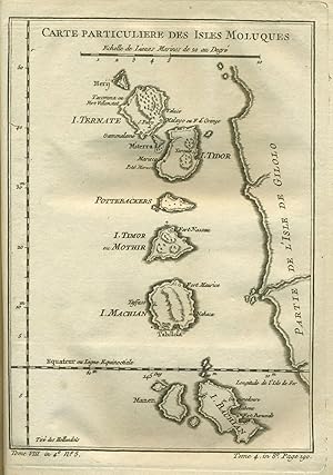
Condition: Very good condition. Detailed copper engraved map of the Moluccas (Maluku), from Herij in the north, down to the Equator and I. Bachian. Includes Ternate, Tidor, Pottebackers, Timor ou Mothir, and Machian. An Indonesian archipelago of islands known as the Spice Islands for the nutmeg, clove and mace originally only fo…und here. From Prevost's "L'Histoire Generale des Voyages". Bellin (1703 - 1772), one of the most noted French mapmakers of the 18th century, was named the hydrographer (chief cartographer) to the French Navy, and later, the Official Hydrographer to the French King. 6 1/2 x 9 1/4". Strong impression, very clean.
Seller: Fahrenheit 451 Antiquarian Booksellers, Nieuwerbrug, NetherlandsFahrenheit 451 Antiquarian Booksellers
Contact seller4-star sellerCondition: Used
US$ 107.27
US$ 41.66 shippingShips from Netherlands to U.S.A.Quantity: 1 available
Rolled tinted lithographed map, varnished and mounted on linen, rolled between two wooden sticks with 2 ties and 3 (of 4) corner ornaments, ca. 71,5 x 44,8 cm. (map)/ 81 x 63 cm. (total size), Topographische Inrichting, Batavia, 1911. = Nice and decorative, detailed map ("schoolkaart") of Halmahera and its many surrounding islan…ds and islets, many listed by their names. "Met administratieve indeling". 'Deze eilandengroep behoort tot de Residentie Ternate en Onderhoorigheden', with a legend. Left section of the map (sea-area) waterstained; some crackle, mainly in lower margin (just outside actual map); small hole in sea are at top; lacking 1 wooden corner-piece.

- Map
Seller: Geographicus Rare Antique Maps, Brooklyn, NY, U.S.A.Geographicus Rare Antique Maps
Contact seller4-star sellerFine or perfect condition. Original platemark visible. Wide clean margins. Blank on verso. Size 6.5 x 9 Inches. This beautiful hand colored map of the Moluques (also known as the Moluccas, Moluccan Islands or simply Maluku) was produced by the French Cartographer Jacques-Nicolas Bellin in 1760. Depicts the islands of Herij, Tern…ate, Tidor, Pottebackers, Timor, Machian and Bachian. The Moluccan islands were once part of the Dutch East Indies. Today the Moluccas are part of Indonesia.

- Map
Seller: Geographicus Rare Antique Maps, Brooklyn, NY, U.S.A.Geographicus Rare Antique Maps
Contact seller4-star sellerExcellent condition. Wide clean margins. Minor marginal mends not affecting printed image. Blank on verso. Size 8.75 x 6 Inches. This is a beautifully engraved 1780 map of the Malaku Islands, or the Moluccas - also known as The Spice Islands. The string of islands, now part of eastern Indonesia, are shown along the west coast of… the island of Halmahera, previously known as Gilolo (and so marked on the map.) Hiri Island, Ternate, Maitara, Tidore, Mare Island (Pottebackers) Moti Island (I. Timor, or Mothir) and Makian Island, are somewhat accurately delineated. Forts and settlements are noted on each island. At the southern extremity of the map, Kasiruta Island (Manen) and Bacan Island are recognizable. It is puzzling that between Makian and Bacan, the islands of Kaioa and Laluin have been omitted - but indeed, this is the case on maps of the Moluccas going back to the Age of Discovery. European explorers, arriving from a trans-Pacific voyage, seem to have coasted Halmahera/Gilolo exclusively from the north, having reached the islands north of New Guinea; this was the case with Magellan's survivors, Drake, and Le Maire. Hence Antonio Pigafetta's (c. 1491 - 1531) 1525 depiction of the Moluccas began with Ternate and ended with Machian; the 1630 Willem Blaeu (1571 - 1638) would do the same, adding Bachian as an inset. Hondius' 1633 map of the Moluccas added Bachian - in very schematic form, and too far north - as an island at the southern end of the chain. The great French geographer, Nicolas Sanson (1600 - 1667), chose this as his model. It appears that despite Bellin's having obtained a significantly better mapping of Bacan, he has been given no cause to question Sanson's placement of the island - or Sanson's naming of settlements and forts, which here is consistent both with the 17th century French geographer's map and its Dutch forebearer. Publication History and Census The separate map appears on the market from time to time but is somewhat neglected in institutional collections: OCLC lists perhaps twenty examples of this map in its various editions. La Harpe's Abrégé de l'histoire générale des voyages is well represented in institutions. References: OCLC 635284726.


