Mortier Corn Wallmap (1 results)
 More images
Published by Amsterdam, Johannes Covens & Cornelis Mortier 1740
Seller: Antiquariaat de Roo, Zwijndrecht, , NetherlandsAntiquariaat de Roo
Contact seller4-star sellerCondition: Used
US$ 34,360.61
US$ 26.69 shippingShips from Netherlands to U.S.A.Quantity: 1 available
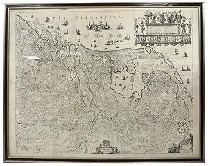
The first wall map of the Seven Provinces of 1651, re-issued as 'Stoel des Oorlogs' by Covens & Mortier. Size 136,5 x 172 cm. The first issue of the present wall-map is known to be included in the Klencke Atlas in the British Library; the second edition, by son Dancker Danckerts, is present in the other two giant atlases: the Me…cklenburg Atlas in Rostock and the Atlas des Grossen Kurfürsten in Berlin. After Nicolaas Visscher published a third state of this decorative piece it was the firm of Covens & Mortier who sold this fourth and final state of the map. Presumably commemorating the 1648 treaty and the Republic's independence, this map might be considered to be a peace-counterpart of the monumental 21-sheet world map that was published by Joan Blaeu in 1648. This historical context, also unveiled by the many decorative and symbolical references, hardly applied to the Covens & Mortier era. However, the new 'Stoel des Oorlogs' title and some minor changes were a poor attempt to bring it more or less up-to-date and fit it into the popular 'Théâtre de la guerre' category. This map, like those in the giant atlases, is a good example of the few surviving cartographic treasures.
