Nares Captain (12 results)

Published by London: Griffin & Co 1874
- Hardcover
- Art Print
Seller: David Ford Books PBFA, Cley-next-the-Sea, , United KingdomDavid Ford Books PBFA
Contact seller5-star sellerCondition: Used - Good
US$ 47.70
US$ 39.70 shippingShips from United Kingdom to U.S.A.Quantity: 1 available
Condition: good. Fifth edition, revised and corrected. Hardcover book . Dark blue cloth over bevelled boards, with gilt title and decorative motif to spine and ship's wheel motif to front. xiv, 256pp, 8pp. With 400 illustrations in plates, mostly good quality line engravings, a few coloured plates of flags etc. Recased with orig…inal cloth laid down and new endpapers. Some light rubbing to boards and spine. A few pages have browned and repaired edges, a few handling marks to margins. A Very Good copy. Pictures available.

Published by Griffin & Co., UK-5th Edt 1874
- Hardcover
Seller: Book Express (NZ), Shannon, New ZealandBook Express (NZ)
Contact seller4-star sellerCondition: Used - Fair
US$ 63.22
US$ 31.00 shippingShips from New Zealand to U.S.A.Quantity: 1 available
Hardcover. Condition: Fair. pp 256 2 plates loose many folding plates worn copy spine strengthened w ith leather strip this is a copy that would need rebinding.
 More images
Language: English
Published by British Admiralty, London 1923
- Map
Seller: Dendera, London, United KingdomDendera
Contact seller5-star sellerCondition: Used - Good
US$ 885.94
US$ 33.08 shippingShips from United Kingdom to U.S.A.Quantity: 1 available
No Binding. Condition: Good. Beautifully drawn b/w chart, printed on heavy paper 86x68cm. Good or better, folded with some ms pencil route annotation and dusting. First published on 31 March 1873, the latest edition stated is 24 April 1922 with small corrections dated 1923. This covers the African side from Abu Dara to the Delta… of the Baraka River including the important trade and Hajj ports of Suakin and Port Sudan, and the Arabian side from Mersa Dheneb to Ras Abu Kalb including Jidda (Jeddah), Lith, and Kunfida. In addition to numerous settlements and geographical features along the coasts, there are 3 insets for Arabian ports including Lith, Jelajil, and Kunfida (surveyed by Commodore JD Nares and the Officers of HM Surveying Ship Enterprise 1918), and 3 African including Khor Delwen, Khor Shinab (Sketch Survey by Lt CH Cochran, HMS Grappler 1885). There are also 4 attractively drawn coastal views.
Published by n.d. c. 1876 1876
- Softcover
Seller: Meridian Rare Books ABA PBFA, London, , United KingdomMeridian Rare Books ABA PBFA
Contact seller5-star sellerCondition: Used - Very good
US$ 115.85
US$ 33.08 shippingShips from United Kingdom to U.S.A.Quantity: 1 available
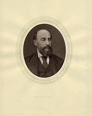
Soft cover. Condition: Very Good. An oval head-and-shoulders portrait of Nares, image size approximately 4.5 x 3.5", mounted as issued to a leaf, together with the accompanying sheet of text by Thompson Cooper with details of Nares's life and achievements.
 More images
Published by HACHETTE, Paris 1880
- Hardcover
- First Edition
Seller: les routes du globe, PARIS, , Franceles routes du globe
Contact seller5-star sellerCondition: Used - Near fine
US$ 153.66
US$ 34.43 shippingShips from France to U.S.A.Quantity: 1 available
Condition: bon. l'édition originale anglaise a paru en 1878. Le but de cette expédition était d'atteindre le pôle en passant par le détroit de Smith, ce qui devait s'avérer impossible. rousseurs aux premiers et derniers feuillets [4]ff + XXIII + 572p ; 2 cartes, frontispice et 62 gravures ds et h.t. Cet ouvrage est disponible à…la librairie. Merci de me contacter avant de vous déplacer 06 51 13 88 91. This book is available at the antiquarian bookstore. demi chagrin rouge, dos à 4 nerfs orné, tranches dorées, Ch.Magnier édition originale de la traduction française.
 More images
Published by Her Majesty's Stationary Office, London 1877
- Hardcover
- First Edition
- Signed
Seller: Polar Books, Llandudno, CONWY, United KingdomPolar Books
Contact seller5-star sellerCondition: Used - Poor
US$ 408.89
US$ 33.08 shippingShips from United Kingdom to U.S.A.Quantity: 1 available
Hardcover (Original Cloth). Condition: Poor. No Dust Jacket. First Edition. Signed by Author. 1st Edition; vii, 484 pages. DAMP DAMAGED - SOLD AS READING COPY ONLY, PRICED ACCORDINGLY. illustrated, ALL MAPS PRESENT uncolored maps (seven folding), seven colored maps (six folding), and sixteen plates (twelve folding). Pages 296 on…wards are in very poor FRAGILE condition, many are torn and edges missing as are the MAPS and illustrations from Page 296 onwards. (A letter laid in from The British Library dated 1979 states the book has become damp then dried too strongly, and that there is little that can be done to restore any strength, only method will be to laminate it) pages 297,298 and page 299,300 and 482,483 are laminated but in all honesty all the rest will need doing, either that or carefully removing and copying. Map pocket in the back is EMPTY but no indication as to map being required in the index. Also included is a signature "G. S. Nares" underlined tipped onto a sheet of paper on which Vice Admiral Sir George S. Nares K.C.B., F.R.S. Leader of "Nares" expedition in Arctic regions. reaches farthest north is written. NO PROVENANCE but nothing to exclude it from being genuine. Hardback cloth covers. This work is the official British government report of the Arctic Expedition of 1876- 7 commanded by Captain George S. Nares. The expedition's primary objective was to attain the highest northern latitude and, if possible, to reach the North Pole, and from winter quarters to explore the adjacent coasts within the reach of traveling parties. The expedition was the first to sail ships through the channel between Greenland and Ellesmere Island and as far north as the Lincoln Sea. A sledging party under Captain Albert Hastings Markham also set a new record on land, reaching as far north as 83° 20'. The "British Arctic expedition of 1875-6, in the vessels Alert and Discovery, [had] the chief aim of which was to reach the north pole. Reports of the American expeditions of Isaac Israel Hayes, 1860-61, and C. F. Hall, 1870-73, had revived the belief in an open polar sea and suggested that land extended far to the north, west of Robeson Channel. Both these theories proved to be wrong, but at the time they indicated the Smith Sound route as the best line of advance to the pole. The vessels sailed on 29 May 1875 and reached winter quarters on the coast of Grinnell Land (Ellesmere Island), the Discovery in latitude 81°44' N., and the Alert, with Nares, in latitude 82°27' N "the most northerly point hitherto reached in the Canadian Arctic" (Levere, 281). The following spring sledge parties were sent out. That led by Lieutenant Pelham Aldrich of the Alert explored the north coast of Ellesmere Island westwards. They reached its most northerly point (Cape Columbia) and continued to Cape Alfred Ernest (Alert Point) before turning back, having charted some 400 km of new coastline (Hattersley-Smith, 121). Lieutenant Lewis A. Beaumont of the Discovery followed the coast of Greenland northwards to Sherard Osborn Fjord. Meanwhile, a party led by Commander A. H. Markham of the Alert struck out over the ice in an attempt to get to the pole. They reached 83°20' N, a heroic achievement considering that the pack ice was extremely rough, and also drifting south almost as fast as they were travelling northwards. Their experience and an outbreak of scurvy affecting both ships led Nares to call off the entire expedition and return home early, in the late summer of 1876" (Oxford DNB). This official work includes reports of the expedition's two ships, the Alert and the Discovery, and various autumn 1875 and spring 1876 traveling parties (including journals of the various sledge parties). The volume provides incredible detail concerning the daily activities and experience of the expedition, including descriptions of the ice, weather, wildlife, vegetation, and the health and activities of the members of the expedition. The appendix (Nares' report on the quality and quantity of the provisions) is also of great interest, noting which supp.
 More images
Published by Griffin & Co, London 1886
- Hardcover
Seller: Jacket and Cloth, Chippenham, United KingdomJacket and Cloth
Contact seller5-star sellerCondition: Used - Very good
US$ 456.60
US$ 29.11 shippingShips from United Kingdom to U.S.A.Quantity: 1 available
Hardcover. Condition: Very Good. No DJ. Published: 1886. 6th Edition. Not signed by author. MS Conway Educational Association. 1886 edition of the naval manual, presented as a prize to one of the most distinguished cadets in the history of HMS Conway and future Master Mariner and Mersey Mission Chairman Francis Conrad Hooper. As…sociation copy of an instruction manual of the Mercantile Marine Service Association. Awarded as a prize to a cadet who would eventually lead the institution's alumni (The Conway Club) and leadership within the Port of Liverpool. PROVENANCE: Presentation Plate: F. C. Hooper dated 1893 and school badge to binding. Emblem: School Ship 'Conway'. DESCRIPTION: School Ship "Conway" prize binding bound in full blue calf leather with gilt badge to front and gilt ruled border. Gilt ruled five ridged spine with gilt decorated panels. Red leather title plate with gilt titles. Marbled endpapers and text block edges. Illustrated with eleven coloured plates and numerous black and white drawings, many fold out, throughout the text Language: English Book Condition: Very Good. Light wear to corners, edges and spine ends. Lightly rubbed leather with clean boards. Tightly bound with clean intact endpapers and strong hinges. Clean unmarked pages. A few loose plates. DJ Condition: No DJ. Pages viii, 291. Size: 21 cm by 14 cm. PROVENANCE BACKGROUND: Francis Conrad Hooper was a distinguished figure in British maritime history whose life was defined by leadership both at sea and within the community of the Port of Liverpool. His career began in the early 1890s as a cadet aboard the naval training ship HMS Conway. He proved to be an exceptional student, rising to the prestigious position of Chief Cadet Captain, or Head Boy, in the autumn of 1894. This early success set the stage for a professional maritime career in which he achieved the rank of Master Mariner, the highest qualification for a sea captain. In addition to his merchant service, he held a commission as a Lieutenant Commander in the Royal Naval Reserve, indicating significant military responsibility. Beyond his time on the bridge of a ship, Hooper was a central pillar of the HMS Conway alumni network. He served as the President of the Conway Club from 1928 to 1929 and dedicated much of his later life to the Conway Benevolent Fund, where he acted as a trustee to support seafarers in financial distress. His most significant humanitarian contribution occurred between 1943 and 1951 when he served as Chairman of the Mersey Mission to Seamen. In this capacity, he oversaw the welfare and care of thousands of sailors during the height of the Second World War and the subsequent period of reconstruction. Following his death on July 15, 1951, his family and friends commissioned a memorial window to honour his dual legacy as a commander and a philanthropist. The School Ship Conway began in 1859 as a maritime training institution established by the Mercantile Marine Service Association to prepare boys for careers in the Royal and Merchant Navies. Its first home was the former HMS Conway, a 28-gun frigate launched in 1839 and stationed on the River Mersey. In 1875 the school transferred to a larger vessel, the ex-HMS Nile, a two-deck ship of the line built in the same year as her predecessor. Renamed Conway, she served for nearly eight decades as a floating classroom and training environment, moored variously at Rock Ferry, Birkenhead, and later in the Menai Strait. In April 1953, while being towed through the Strait for refit, the ship grounded on the Platters and sustained severe structural damage. Although initial salvage attempts offered some hope, subsequent storms broke the hull apart, and the remains were later destroyed by fire in 1956. The training establishment continued ashore at Plas Newydd on Anglesey, where it operated until its closure in 1974. Over more than a century of service, the Conway produced generations of seafarers and left a lasting legacy within British maritime education.
 More images
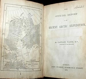
Published by John Murray, London 1876
- Hardcover
- First Edition
Seller: Bailgate Books Ltd, Doncaster, , United KingdomBailgate Books Ltd
Contact seller5-star sellerCondition: Used - Good
US$ 632.42
US$ 19.19 shippingShips from United Kingdom to U.S.A.Quantity: 1 available
Hardcover. Condition: Good. No Dust Jacket. First Edition. Report to the Admiralty of the expedition that left Upernivick on 22 July 1875 and returning in October 1876. This is an ex-library copy with flaws as described. Black half-leather binding with banded spine and dark blue covers are lightly rubbed at edges, binding is sou…nd with strengthened inner hinges. Crossed and stamped large library label is pasted to the inside of the front cover, additional end-papers (darkened), no half-title-page, frontis map has been pasted to previous end-paper with resultant wrinkles on both surfaces and a stamp of "Free Public Library Westminster S.W." on the obverse of the frontis shows through the pasted end-paper (although not visible from the map. Title-page is darkened, has a crossed out reference number in the upper leading corner and a psted paper rectangle covering a "Free Public Library Westminster S.W." stamp, small feint stamp on reverse and short closed tear (approx 1cm) on leading edge. Pages are little darkened with some smudge marks mainly in margins, page 84 to 91have a very small ink mark on the lower corner, "Free Public Library Westminster S.W." stamp acorss the bottom of the final page. Quantity Available: 1. Shipped Weight: under 1 kg. Pictures of this item not already displayed here available upon request. Inventory No: 61115030126. All our books are sent by tracked mail.
 More images
Published by London John Murray 1876 1876
- Softcover
- First Edition
Seller: Aquila Books(Cameron Treleaven) ABAC, Calgary, AB, CanadaAquila Books(Cameron Treleaven) ABAC
Contact seller3-star sellerCondition: Used
US$ 872.83
US$ 19.00 shippingShips from Canada to U.S.A.Quantity: 1 available
First Edition 96 pp. Octavo (21.5 X 14.2 cm.) Original printed blue wrappers. Old crease to the front wrapper. Early contemporary signature to the title page. Professional restoration to the spine and a few chips on the edges. Illustrated with frontispiece map showing the Arctic regions and recent explorations made in H. M. Ship…s Alert and Discovery 1875-6. A very good plus copy, very clean. Not in AB. This is the first published account of the Arctic expedition led by Captain George Nares in the ships H.M.S. "Alert" and H.M.S. "Discovery". This account starts with the ships leaving Upernivik on July 22nd, 1875, to find the best route to the North Pole. The ships returned to Portsmouth in October 1876 after experiencing many hardships including the outbreak of scurvy among the crew. Consists of a short synopsis of events that occurred during the Expediton: "First ice sighted off Cape Sabine", "Formation of an Ice Floe", News from Greenland Division" etc. Very Scarce.
 More images
Published by H.M.S.O., London 1882
- Hardcover
- First Edition
Seller: Muir Books [Robert Muir Old & Rare Books], PERTH, WA, AustraliaMuir Books [Robert Muir Old & Rare Books]
Contact seller5-star sellerCondition: Used
US$ 1,804.92
US$ 28.00 shippingShips from Australia to U.S.A.Quantity: 1 available
Leather. 1st edition. 1st ed., quarto, pp.(iii), 192, stamp of Zoology Dept (London) to upper title. page 99 and last text page, 13 full-page sepia lithographic plates, small repair to upper title page and some wear and chipping to edges of last plate, bound in kangaroo skin, gilt ruled and blind-embossed borders, ornate gilt de…c spine and gilt titled leather label. Very good condition. Rare. Report on the Scientific Results of the Voyage of HMS Challenger during the years 1873-76. Most of the report relates to the findings on the Thylacine and published as Volume 5 (Zoology) of "Report on the Scientific Results of the Voyage of H.M.S. Challenger". Includes work on Cuscus and Phascogale. The Tasmanian tiger or Thylacine was an iconic Australian marsupial predator that was hunted to extinction in the early 1900's. During H.M.S. Challenger's stay in Sydney in 1874, two specimens (male and female) of the thylacine were presented to the scientists on board by Charles Du Cane, the then Governor of Tasmania and taken back to the British vertebrate zoologist and anatomist, Dr Daniel John Cunningham. Much of what we know today about the internal anatomy of the thylacine is derived from Cunningham's meticulous anatomical dissections and published here in this report. Eight plates (of thirteen) in the report relate to the now extinct Thylacine: Plates I, IV, V, VI, IX, X, XII, XII.
 More images
Published by London and Portsmouth Mess. J. Griffon & Co. 1875 1875
- Photo
Seller: Aquila Books(Cameron Treleaven) ABAC, Calgary, AB, CanadaAquila Books(Cameron Treleaven) ABAC
Contact seller3-star sellerCondition: Used
US$ 254.58
US$ 19.00 shippingShips from Canada to U.S.A.Quantity: 1 available
CDV albumen photograph (92 X 60 mm.) Image mounted on original printed photographers mount. Tones just slightly light otherwise in excellent condition. Very attractive head and shoulders image of Nares in full naval uniform and sporting a wonderful full beard. No photographer is indicated so I am assuming the image was done for…Griffin or by a staff photographer. Certainly an uncommon image.
 More images
Published by British Admiralty, London 1922
- Map
Seller: Dendera, London, United KingdomDendera
Contact seller5-star sellerCondition: Used - Good
US$ 1,294.83
US$ 33.08 shippingShips from United Kingdom to U.S.A.Quantity: 1 available
No Binding. Condition: Good. Beautifully drawn b/w chart with some hand colouring, printed on heavy paper 85x70cm. Good or better, folded with some ms pencil annotation and dusting. First published on 31 March 1873, the latest edition stated is 24 April 1922 with small corrections dated in the same year. This covers the African…side from the Arab Encampment north of Jebel Kuweh to Abu Dara including Koseir (Qoseir), and the Arabian side from Ras Morabit to Merea Dheneb including Wej (Wejh) and Yenbo ("Port of Medina / Cattle and water cheap & good"). In addition to numerous settlements and geographical features along the coasts, there are 7 inset maps and plans for Foul Bay Scout Anchorage (credited to Lt. E.H. Dobbin, HMS Scout, 1902), The Brothers Islands, Koseir Anchorage (credited to Captain G.S. Nares RN, 1872), Sherm Wej, Sherm Hassey, Daedelus Reef (credited to Commodore A. Carpenter, HMS Myrmidon, 1884), and Yenbo. The plan of Wej, 1/7270, shows the detailed layout of the town with its street pattern, including the gateway, fort (ruined), minarets, tombs, towers, old boiler, boulders, ruins, and pier under construction. The plan of Yenbo, 1/29,740, dated from latest information to 1916 around the time of the Arab Revolt, shows the town demarcated by its wall with bastions, minarets, high house, old battery, and its environs including a conspicuous tomb, and a caution dated 1921 that the beacons are not to be relied upon. The main map also features 2 attractively drawn coastal views (one of which is almost the full length of the left hand border), and 2 inset drawings of the lighthouses at The Brothers and Daedelus Reef. The pencil annotations are of courses drawn from these two locations.


