Order Total (1 Item Items):
Shipping Destination:

Nautical Chart (165 results)
Skip to main search results
Search filters
Product Type
- All Product Types
- Books (80)
- Magazines & Periodicals (No further results match this refinement)
- Comics (No further results match this refinement)
- Sheet Music (No further results match this refinement)
- Art, Prints & Posters (No further results match this refinement)
- Photographs (No further results match this refinement)
- Maps (85)
- Manuscripts & Paper Collectibles (No further results match this refinement)
Condition Learn more
- New (7)
- As New, Fine or Near Fine (No further results match this refinement)
- Very Good or Good (No further results match this refinement)
- Fair or Poor (No further results match this refinement)
- As Described (158)
Binding
Collectible Attributes
- First Edition (11)
- Signed (No further results match this refinement)
- Dust Jacket (No further results match this refinement)
- Seller-Supplied Images (159)
- Not Print on Demand (160)
Language (2)
Free Shipping
Seller Location
Seller Rating
-

-
-

Martha's Vineyard Nautical Chart Log Book Lined Pages: 7 1/2 x 9 3/4 Inch - 200 lined pages, college ruled
Language: English
Published by CreateSpace Independent Publishing Platform, 2017
ISBN 10: 1979709823 ISBN 13: 9781979709828
US$ 16.37
US$ 16.67 shipping
Ships from United Kingdom to U.S.A.Quantity: 1 available
Add to basketPaperback. Condition: Brand New. 202 pages. 9.69x7.44x0.46 inches. This item is printed on demand.
-

British Columbia. Sand Heads to Ballenas Islands
Published by Ottawa: Hydrographic and Map Service, 1943 (Small corrections to 1944 [mss.])., 1944
Seller: William Matthews/The Haunted Bookshop, Sidney, BC, Canada
Seller rating 5 out of 5 stars

First Edition
An engraved chart, 4-color, on heavy stock. Sheet size is 42 x 29 inches. Original vertical fold, a working copy with extensive additions and notes in red ink, dust soiling and some wear to fold. Chart number is 3577. This is the first edition of April, 1943, with mss. Small corrections to 1944. Red ink stamp on verso indicating chart and folio information. Part of the Strait of Georgia, showing Nanaimo and Gabriola Island, and the tips of Lasqueti Island and Texada Island; also Bowen Island and the entrance to Burrard Inlet.
-

North America - West Coast. Alaska. Dixon Harbour. From the United States Government Chart. 1906. With additions and corrections to 1929.
Published by London: British Admiralty, 1907 (1930)., 1930
Seller: William Matthews/The Haunted Bookshop, Sidney, BC, Canada
Seller rating 5 out of 5 stars
An engraved chart on heavy stock, uncolored, sheet size 20 x 27.5 inches. Published 5th March, 1907; New Edition 14th Feb. 1930. Clean and attractive, never folded. In lower right: "Engraved 1907" and "Zc1930". Chart number is 3633. Small typed label on verso giving chart & folio info. Published under the Superintendence of Rear Admiral A. Mostyn Field.
-
Alaska. Chatham Strait. Whitewater and Chaik Bays. From the United States Government Chart, 1906.
Published by London: British Admiralty, 1907 (1924)., 1924
Seller: William Matthews/The Haunted Bookshop, Sidney, BC, Canada
Seller rating 5 out of 5 stars
An engraved chart on heavy stock, uncolored, sheet size 20 x 27.5 inches. Published 22nd April 1907; Small corrections (printed) to 1924. Unfolded. A nice clean copy. In lower right: "Engraved by Davies & Company". Chart number is 3653. Small typed label on verso giving chart & folio info. Published under the Superintendence of Rear Admiral A. Mostyn Field.
-
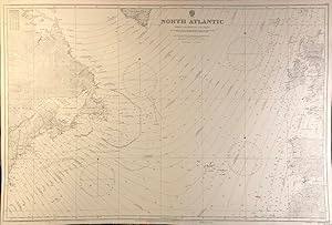
North Atlantic From Lat.29.N to Lat.62.N
Published by London: British Admiralty, 1923 (printed corrections to 1930; mss. corrections to 1933), 1933
Seller: William Matthews/The Haunted Bookshop, Sidney, BC, Canada
Seller rating 5 out of 5 stars
An engraved chart on heavy stock, uncolored, sheet size 40 x 27.5 inches. Published 12th April, 1923; Large corrections 1928; printed Small corrections to 1930; mss. corrections to 1933. Vertical fold, a nice clean copy, some small marks and notes in red pen. In lower right: "Engraved by Davies & Company". Chart number is 2058A. Small typed label on verso giving chart & folio info. Published under the Superintendence of Rear Admiral Fredk. C. Learmonth.
-
British Columbia. Vancouver Harbour. Sheet 3 (Second Narrows to Port Moody).
Published by Ottawa: Hydrographic and Map Service, 1942 (Small corrections to 1943)., 1943
Seller: William Matthews/The Haunted Bookshop, Sidney, BC, Canada
Seller rating 5 out of 5 stars
An engraved chart, 4-color, on heavy stock. Sheet size is 42 x 28.5 inches. Original vertical fold, a very clean copy, a few small red marks in pen. Two small paste-on corrections on the coast near Port Moody. Chart number is 334. First published in 1930; this is the October, 1942 Edition, with printed Small corrections to 1943. Red ink stamp on verso indicating chart and folio information.
-

British Columbia. Plans in the Vicinity of Strait Of Georgia.
Published by Ottawa: Hydrographic and Map Service, 1934 (Small corrections to 1944)., 1944
Seller: William Matthews/The Haunted Bookshop, Sidney, BC, Canada
Seller rating 5 out of 5 stars
An engraved chart, 4-color, on heavy stock. Sheet size is 34 x 29 inches. Original vertical fold, a very clean copy, a couple of tiny marks in red pen. Chart number is 308. First published 1934, this is an edition of 1944. Red ink stamp on verso indicating chart and folio information. Eight charts: Lodge and Wharf Coves, Head of Howe Sound, Powell River, Sturdies Bay, Tucker Bay, Genoa Bay, Stillwater, and Shoal Channel.
-

Nautical Chart Design Graph Paper Book: 8 1/2 x 11 Inch, 200 pages
Language: English
Published by CreateSpace Independent Publishing Platform, 2017
ISBN 10: 1975650875 ISBN 13: 9781975650872
US$ 19.80
US$ 16.67 shipping
Ships from United Kingdom to U.S.A.Quantity: 1 available
Add to basketPaperback. Condition: Brand New. 200 pages. 11.00x8.50x0.46 inches. This item is printed on demand.
-

Nautical Chart Design Journal - Blank Pages: 200 Pages - 8 1/2 x 11 Inches
Language: English
Published by CreateSpace Independent Publishing Platform, 2017
ISBN 10: 1975746430 ISBN 13: 9781975746438
US$ 19.92
US$ 16.67 shipping
Ships from United Kingdom to U.S.A.Quantity: 1 available
Add to basketPaperback. Condition: Brand New. 200 pages. 11.00x8.50x0.46 inches. This item is printed on demand.
-

Boston Harbor Nautical Map Chart Journal: 7 1/2 x 9 3/4 Inch - 200 lined pages, college ruled
Language: English
Published by CreateSpace Independent Publishing Platform, 2018
ISBN 10: 1983662453 ISBN 13: 9781983662454
US$ 22.39
US$ 16.67 shipping
Ships from United Kingdom to U.S.A.Quantity: 1 available
Add to basketPaperback. Condition: Brand New. 202 pages. 9.69x7.44x0.46 inches. This item is printed on demand.
-
![Seller image for British Columbia. Queen Charlotte Islands - Graham Island. Port Louis to Parry Passage. [Haida Gwaii] for sale by William Matthews/The Haunted Bookshop](https://pictures.abebooks.com/inventory/md/md30774801399.jpg)
British Columbia. Queen Charlotte Islands - Graham Island. Port Louis to Parry Passage. [Haida Gwaii]
Published by London: British Admiralty, 1918 (1919)., 1919
Seller: William Matthews/The Haunted Bookshop, Sidney, BC, Canada
Seller rating 5 out of 5 stars
A large engraved chart on heavy stock, uncolored, sheet size 28 x 50 inches. Originally published 1918, this is an edition with Small corrections to 1919. Original horizontal folds, a nice clean copy, some small corrections in red. At lower right: "Engraved by Davies & Company". Chart number is 3751. Small typed label on verso, giving chart & folio information. Produced under the Superintendence of Rear Admiral J.F. Parry. A large chart; the lower one-third is a close-up chart of Port Louis and Otard Bay on Graham Island, Haida Gwaii.
-

England - South Coast. Approaches to Falmouth.
Published by London: British Admiralty, 1872 (1927)., 1927
Seller: William Matthews/The Haunted Bookshop, Sidney, BC, Canada
Seller rating 5 out of 5 stars
An engraved chart on heavy stock, uncolored, sheet size 27.5 x 40 inches. Published 1872; New Edition 1915. Small corrections to 1927 (printed) and 1932 (mss.). Original horizontal fold, a very clean copy, some small additions in red pen and one small paste-over correction. In lower right: "Engraved by Davies Bryer & Co." and "Zc 1925". Chart number is 154. Small typed label on verso giving chart & folio info. Published under the Superintendence of Rear Admiral G.H. Richards. Several inset engravings of shorelines, and an inset map of Truro.
-

England - South Coast. Portland to Christchurch.
Published by London: British Admiralty, 1893 (1933)., 1933
Seller: William Matthews/The Haunted Bookshop, Sidney, BC, Canada
Seller rating 5 out of 5 stars
An engraved chart on heavy stock, uncolored, sheet size 28 x 46 inches. Published 1893; New Edition 1922. Small corrections to 1933 (printed). Original vertical folds, a very clean copy; some corrections and additions in red. In lower right: "Engraved by Davies & Company" and "Zc 1933". Chart number is 2615. Small typed label on verso giving chart & folio info. Published under the Superintendence of Captain W.J.L. Wharton. One short engraved coastline at the bottom.
-

England - South Coast. Lizard Hd. to Start Pt.
Published by London: British Admiralty, 1900 (1928)., 1928
Seller: William Matthews/The Haunted Bookshop, Sidney, BC, Canada
Seller rating 5 out of 5 stars
An engraved chart on heavy stock, uncolored, sheet size 40 x 27.5 inches. Published 1900; New Edition 1912. Small corrections to 1927 (printed) and 1932 (mss.). Original vertical fold, a very clean copy; some corrections and additions in red. In lower right: "Engraved by Davies & Company" and "Zc 1928". Chart number is 442. Small typed label on verso giving chart & folio info. Published under the Superintendence of Rear Admiral Sir W.J.L. Wharton. Two short engraved coastlines at the top.
-

England - South Coast. Owers to Dungeness.
Published by London: British Admiralty, 1878 (1931)., 1931
Seller: William Matthews/The Haunted Bookshop, Sidney, BC, Canada
Seller rating 5 out of 5 stars
An engraved chart on heavy stock, uncolored, sheet size 40 x 27.5 inches. Published 1878; New Edition 1920. Small corrections to 1931 (printed) and 1932 (mss.). Original vertical fold, a very clean copy, some small additions in red pen. In lower right: "Engraved 1878 / Electro. 1931". Chart number is 2451. Small typed label on verso giving chart & folio info. Published under the Superintendence of Captain F.J. Evans. Lighthouse and coastal engraving at the top.
-

England - South Coast. Dungeness to the Thames including Dover Strait.
Published by London: British Admiralty, 1875 (1930)., 1930
Seller: William Matthews/The Haunted Bookshop, Sidney, BC, Canada
Seller rating 5 out of 5 stars
An engraved chart on heavy stock, uncolored, sheet size 27.5 x 40 inches. Published 1875; New Edition 1928. Small corrections to 1930 (printed) and 1931 (mss.). Original horizontal fold, a very clean copy, some small additions in red pen and two small paste-over corrections. In lower right: "Engraved 1875 / Processed 1923". Chart number is 1895. Small typed label on verso giving chart & folio info. Published under the Superintendence of Captain F.J. Evans. Several inset engravings of lighthouses.
-
America - North West Coast. Alaska. Anchorages In and Near Sumner Strait. From Plans Published by the U.S. Government, 1888.
Published by London: British Admiralty, 1890 (1924)., 1924
Seller: William Matthews/The Haunted Bookshop, Sidney, BC, Canada
Seller rating 5 out of 5 stars
An engraved chart on heavy stock, uncolored, sheet size 33.5 x 27 inches. Published 11th Aug. 1890; Large Corrections to Aug. 1898; Small corrections (printed) to 1924 and (mss.) to 1927. Original vertical fold, a nice clean copy, small additions in red pen. In lower right: "Engraved by Edwd. Weller". Chart number is 1449. Small typed label on verso giving chart & folio info. Published under the Superintendence of Captain W.J.L. Wharton. Two large charts of anchorages: Port McArthur and Red Bay; the Port McArthur plan includes a small inset map of Port Conclusion.
-
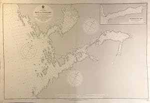
Alaska. Chatham Strait. Bay of Pillars. From the latest United States Government Chart, 1907.
Published by London: British Admiralty, 1908 (1925)., 1925
Seller: William Matthews/The Haunted Bookshop, Sidney, BC, Canada
Seller rating 5 out of 5 stars
An engraved chart on heavy stock, uncolored, sheet size 40 x 27.5 inches. Published 29th Sept. 1908; Small corrections (printed) to 1925. Original vertical fold, a nice clean copy, a couple of small additions in red pen. In lower right: "Engraved by Weller & Addison". Chart number is 3705. Small typed label on verso giving chart & folio info. Published under the Superintendence of Rear Admiral A. Mostyn Field. Includes an inset map of Washington Bay. Originally published in 1908, this is a printing of 1925.
-
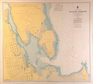
British Columbia. Vancouver Island. Nanaimo Harbour.
Published by Ottawa: Hydrographic and Map Service, 1939 (Small corrections in mss. to 1944), 1944
Seller: William Matthews/The Haunted Bookshop, Sidney, BC, Canada
Seller rating 5 out of 5 stars
First Edition
An engraved chart, 4-colour, on heavy stock. Sheet size is 31.5 x 28.5 inches. Original horizontal fold, a nice clean copy, a few small marks in red pen. Chart number is 381. This is the 1939 first edition, with mss. Small corrections to 1944. Red ink stamp on verso indicating chart and folio information. The coast at Nanaimo, showing Protection Island and Newcastle Island.
-

North America - West Coast. South Side of Vancouver I. Esperanza to Clayoquot Including Nootka Sound.
Published by London: British Admiralty, 1865 (Edition of 1918, Small corrections to 1930 [printed] and 1935 [mss.], 1935
Seller: William Matthews/The Haunted Bookshop, Sidney, BC, Canada
Seller rating 5 out of 5 stars
An engraved chart on heavy stock, uncolored, sheet size 27.5 x 40 inches. Originally published 1865, this is an edition of 1930, with mss. corrections to 1935. Original horizontal fold, a nice clean copy, some small marks and notes in red pen and pencil. At lower right: "Engraved by Davies & Powell". Chart number is 569. Small typed label on verso, giving chart & folio information. Drawn by E.J. Powell. Produced under the Superintendence of Capt. G.H. Richards. A handsome chart of Nootka Sound, with an inset map of Hesquiat Harbour.
-

North America - West Coast. British Columbia. Nass Bay.
Published by London: British Admiralty, 1872 (1915)., 1915
Seller: William Matthews/The Haunted Bookshop, Sidney, BC, Canada
Seller rating 5 out of 5 stars
An engraved chart on heavy stock, uncolored, sheet size 27.5 x 20 inches. Originally published 1872, this is a New Edition of 1915, No folds, a very good copy, some wear and wrinkling to lower edge. At lower right: "Engraved by Davies, Bryer & Co.". Chart number is 2190. Small typed label on verso, giving chart & folio information. Produced under the Superintendence of Rear Admiral G.H. Richards. The lower right is an inset map of the Nass River. Engraved shoreline inset at upper left.
-

North America - West Coast. British Columbia. Edye Passage to Portland Inlet.
Published by London: British Admiralty, 1912 (1925)., 1925
Seller: William Matthews/The Haunted Bookshop, Sidney, BC, Canada
Seller rating 5 out of 5 stars
An engraved chart on heavy stock, uncolored, sheet size 26.5 x 44 inches. Originally published 1912, this is an edition of 1925, with mss. corrections to 1928. Original horizontal folds, a nice clean copy, some small corrections in red. At lower right: "Engraved by Weller & Addison". Chart number is 1737. Small typed label on verso, giving chart & folio information. Produced under the Superintendence of Rear Admiral H.E. Parry. Good detail of the Dundas Islands, Chatham Sound.
-
![Seller image for North America - West Coast. British Columbia. Plans of Anchorages in Queen Charlotte Islands. [Haida Gwaii]. for sale by William Matthews/The Haunted Bookshop](https://pictures.abebooks.com/inventory/md/md30774806073.jpg)
North America - West Coast. British Columbia. Plans of Anchorages in Queen Charlotte Islands. [Haida Gwaii].
Published by London: British Admiralty, 1924., 1924
Seller: William Matthews/The Haunted Bookshop, Sidney, BC, Canada
Seller rating 5 out of 5 stars
An engraved chart on heavy stock, uncolored, sheet size 40 x 27.5 inches. Published 1924, this has mss. Small corrections to 1927. Original vertical fold, a nice clean copy, some small corrections in red, and one paste-over correction. At lower right: "Engraved by Davies & Company". Chart number is 3711. Small typed label on verso, giving chart & folio information. Produced under the Superintendence of Vice Admiral Fredk. C. Learmonth. The right half of this chart is blank; the left side is one large chart: Graham Island - North Coast. Masset Sound and Inlet. [Haida Gwaii].
-

North America - West Coast. British Columbia. Port Simpson.
Published by London: British Admiralty, 1907 (1923)., 1923
Seller: William Matthews/The Haunted Bookshop, Sidney, BC, Canada
Seller rating 5 out of 5 stars
An engraved chart on heavy stock, uncolored, sheet size 40 x 27.5 inches. Originally published 1907, this is an edition with printed Small corrections to 1923. Original vertical fold, a nice clean copy, some small corrections in red. At lower right: "Engraved by Davies & Company". Chart number is 3678. Small typed label on verso, giving chart & folio information. Produced under the Superintendence of Rear Admiral A. Mostyn Field. Detail of Port Simpson, showing the location of totem poles, the Indian Burial Ground, the Chief's house.
-

England - South Coast. Tor Bay.
Published by London: British Admiralty, 1908 (1928), 1928
Seller: William Matthews/The Haunted Bookshop, Sidney, BC, Canada
Seller rating 5 out of 5 stars
An engraved chart on heavy stock, uncolored, sheet size 29 x 34.5 inches. Published 1908; New Edition 1911. Small corrections to 1928 (printed). Original horizontal and vertical folds, a very clean copy; some corrections and additions in red. In lower right: "Engraved by Weller & Addison". Chart number is 26. Small typed label on verso giving chart & folio info. Published under the Superintendence of Rear Admiral A. Mostyn Field. Small inset map of Torquay Harbour at the upper left.
-

England - South Coast. Portland Harbour.
Published by London: British Admiralty, 1908 (1930)., 1930
Seller: William Matthews/The Haunted Bookshop, Sidney, BC, Canada
Seller rating 5 out of 5 stars
An engraved chart on heavy stock, uncolored, sheet size 27 x 34 inches. Published 1908; New Edition 1922. Small corrections to 1930 (printed) and 1932 (mss.). Original horizontal fold, a very clean copy; some corrections and additions in red, and one paste-over correction at Weymouth Harbour. In lower right: "Engraved by Davies & Company" and "Zc 1930". Chart number is 2268. Small typed label on verso giving chart & folio info. Published under the Superintendence of Rear Admiral A. Mostyn Field. Small inset map of Portland Coaling Piers at lower left.
-

England - South Coast. Approaches to Plymouth.
Published by London: British Admiralty, 1890 (1928)., 1928
Seller: William Matthews/The Haunted Bookshop, Sidney, BC, Canada
Seller rating 5 out of 5 stars
An engraved chart on heavy stock, uncolored, sheet size 40 x 27.5 inches. Published 1890; New Edition 1911. Small corrections to 1928 (printed) and 1932 (mss.). Original vertical fold, a very clean copy; some corrections and additions in red. In lower right: "Engraved by Edwd. Weller" and "Zc 1926". Chart number is 1267. Small typed label on verso giving chart & folio info. Published under the Superintendence of Captain W.J.L. Wharton. One engraved coastline at the bottom.
-

England - South and West Coasts. Trevose Head to Dodman Point Including The Scilly Isles.
Published by London: British Admiralty, 1888 (1928), 1928
Seller: William Matthews/The Haunted Bookshop, Sidney, BC, Canada
Seller rating 5 out of 5 stars
An engraved chart on heavy stock, uncolored, sheet size 27.5 x 40 inches. Published 1888; New Edition 1920; Large corrections to 1928 (printed) and 1933 (mss.). Original vertical fold, a clean copy; some corrections and additions in red. In lower right: "Engraved 1888" and "Zc 1928". Chart number is 2565. Small typed label on verso giving chart & folio info. Published under the Superintendence of Captain W.J.L. Wharton. Engraved coastline at the bottom. Cornwall and the Scilly Islands.