
Order Total (1 Item Items):
Shipping Destination:

Niger River (3 results)
Skip to main search results
Search filters
Product Type
- All Product Types
- Books (1)
- Magazines & Periodicals (1)
- Comics (No further results match this refinement)
- Sheet Music (No further results match this refinement)
- Art, Prints & Posters (No further results match this refinement)
- Photographs (No further results match this refinement)
- Maps (1)
- Manuscripts & Paper Collectibles (No further results match this refinement)
Condition Learn more
- New (No further results match this refinement)
- As New, Fine or Near Fine (No further results match this refinement)
- Very Good or Good (2)
- Fair or Poor (No further results match this refinement)
- As Described (1)
Binding
- All Bindings
- Hardcover (No further results match this refinement)
- Softcover (1)
Collectible Attributes
- First Edition (1)
- Signed (No further results match this refinement)
- Dust Jacket (No further results match this refinement)
- Seller-Supplied Images (3)
- Not Print on Demand (3)
Language (1)
Free Shipping
- Free Shipping to U.S.A. (No further results match this refinement)
Seller Location
Seller Rating
-
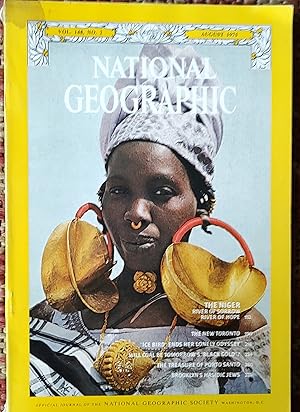
National Geographic Magazine August 1975 / "The Niger: River of Sorrow, River of Hope;" "The New Toronto;" "Ice Bird Ends Her Lonely Odyssey;" "Will Coal be Tomorrow's Black Gold?;" "The Treasure of Porto Santo;" "Brooklyn's Hasidic Jews"
Published by The National Geographic Society, 1975
Magazine / Periodical
US$ 20.78
US$ 14.79 shipping
Ships from United Kingdom to U.S.A.Quantity: 1 available
Add to basketSoft cover. Condition: Very Good. "The Niger: River of Sorrow, River of Hope;" "The New Toronto;" "Ice Bird Ends Her Lonely Odyssey;" "Will Coal be Tomorrow's Black Gold?;" "The Treasure of Porto Santo;" "Brooklyn's Hasidic Jews".
-

Art. IX. - Travels through the Timannee, Kooranko, and Soolima Countrires, to the Sources of the Rokelle and Niger, in the Year 1822. by Captain A. Gordon Laing. with a Map and Plates. 8vo. - Disbound from the Quarterly Review 1825.
Published by John Murray, London, 1825
Seller: Literary Cat Books, Machynlleth, Powys, WALES, United Kingdom
Association Member: IOBA
Seller rating 4 out of 5 stars

First Edition
Disbound. Condition: Very Good. Dust Jacket Condition: No Dust Jacket. First Edition; First Edition. Pages 485-474. Last page loose. Light wear. This is an original book review from the 19th century. ; Octavo (standard book size).
-

Guineae Nova Descriptio.
Publication Date: 1606
Seller: Geographicus Rare Antique Maps, Brooklyn, NY, U.S.A.
Association Member: ABAA ESA ILAB
Seller rating 4 out of 5 stars
Map
Very good. Wide margins and a bold strike; few filled wormholes with some reinstatement of image. Centerfold reinforced. Size 13.75 x 19.5 Inches. This is Jodocus Hondius' 1606 map of the Guinea coast of Africa, stretching from the mouth of the Senegal River to Cape Lopez, from modern Senegal to Benin. It shows this coast at a time when its trade was largely controlled by the Portuguese, with whom the Dutch were at war; this map thus presented to a Dutch audience what would have been considered a rich prize to be taken. A Superb Engraving The engraving of this map displays the high standard of Hondius' work. Mountains and water areas feature bold hachure. The lettering is sharp and legible, not only in its fine Italics but also the elaborate calligraphy, most notably the riotous flourishes announcing 'Zegzey' north of the kingdom of Benin. A native sailing canoe is contrasted agasint a European galleon, firing cannon. Strapwork designs set off the title cartouche, the scales, and the inset map of S�o Tome. The Portuguese Foothold in Africa The notations here are in Portuguese. The inland notation of 'Corisseno de Aliphante grande' (District of large elephants) appears to derive from a 1602 map by the Portuguese Jesuit Luis Teixeira, and it is likely that Hondius' other details hail from the same source. The Portuguese established trading factories along this coast to export ivory (hence 'de Aliphante grande' ), gold, and increasingly, enslaved Africans. Among the installations marked along the coast is the infamous Castel de la Mina, a transshipment entrep�t for Africans captured and enslaved throughout the Slave Coast of Benin. S�o Tome The importance of this island off the coast of Benin is emphasized by the inclusion of the detailed inset map. The Portuguese settlers established sugar plantations there, and imported enslaved Africans from the mainland to operate them due to Sickle cell trait (SCT) making them more resistant to malaria. Some trace the Portuguese efforts to establish viable sugar plantaios on S�o Tome as the origins of chattel slavery. By the middle of the 16th century S�o Tome had become Africa's primary exporter of sugar. The inset map marks the island's primary settlement, but also sugar mills and plantations. Publication History and Census This map was engraved for inclusion in Jodocus Hondius' 1606 Atlas, among the maps he produced to supplement those he acquired from Mercator. It would remain in the Hondius atlases until about 1639, at which time it was supplanted by a more modern map engraved by Jansson. The verso text of the present example conforms typographically to the 1630 Latin edition of Henry Hondius' Atlas, editio decima . In its various editions, this map is well represented in institutional collections. Two of this specific edition are listed in the University of Bern and the Herzogin Anna Amalia Bibliothek Klassik. References: Rumsey 10501.463. Norwich, O., Maps of Africa, #316.