Peru Map (30 results)

Seller: Speedyhen LLC, Hialeah, U.S.A.Speedyhen LLC
Contact seller2-star sellerCondition: New
US$ 14.37
Free ShippingShips within U.S.A.Quantity: 10 available
Condition: NEW.

Seller: N. Fagin Books, Chicago, U.S.A.N. Fagin Books
Contact seller5-star seller1986. South America, map. Mapa politico redactado por el Instituto Geografico Nacional 1:1'600,000. segund edicion.
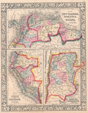
Map of New Granada, Venezuela, and Guiana / Map of Peru, and Equador / Map of the Argentine Confederation
(NEW GRANADA -- VENEZUELA -- GUIANA -- PERU -- EQUADOR -- ARGENTINA -- Map)
Published by S. Augustus Mitchell, Jr., New York 1860
- Map
Seller: Main Street Fine Books & Mss, ABAA, Galena, U.S.A.Main Street Fine Books & Mss, ABAA
Contact seller5-star sellerFolio (12¼" X 15¼", image area 10½" X 13½"). Hand colored. Very good. Mild age toning and bit of faint soiling. Quite nice map of these half dozen South American countries, from the 1864 edition of "Mitchell's New General Atlas, Containing Maps of the Various Countries of the World, Plans of Cities, Etc." Upper third contains "M…ap of New Granada, Venezuela, and Guiana," lower left third contains "Map of Peru, and Equador" and lower right third contains "Map of the Argentine Confederation." Today "New Granada" consists of Colombia and Panama. Wonderfully, delicately colored, with fine decorative border.
Map of New Granada, Venezuela, and Guiana / Map of Peru, and Equador / Map of the Argentine Confederation
(NEW GRANADA -- VENEZUELA -- GUIANA -- PERU -- EQUADOR -- ARGENTINA -- Map)
Published by S. Augustus Mitchell, Jr., New York 1860
- Map
Seller: Main Street Fine Books & Mss, ABAA, Galena, U.S.A.Main Street Fine Books & Mss, ABAA
Contact seller5-star sellerFolio (12¼" X 15¼", image area 10½" X 13½"). Hand colored. Near fine. Quite faint age toning. Bold, bright and lovely map of these half dozen South American countries, from the 1864 edition of "Mitchell's New General Atlas, Containing Maps of the Various Countries of the World, Plans of Cities, Etc." Upper third contains "Map of… New Granada, Venezuela, and Guiana," lower left third contains "Map of Peru, and Equador" and lower right third contains "Map of the Argentine Confederation." Today "New Granada" consists of Colombia and Panama. Wonderfully, delicately colored, with fine decorative border.
Published by Charles Desilver, Philadelphia 1856
- Map
Seller: Main Street Fine Books & Mss, ABAA, Galena, U.S.A.Main Street Fine Books & Mss, ABAA
Contact seller5-star seller17¼" X 13 3/4" (image 15" X 12½"). Hand colored. Decorative border. Very good. 2" tear at upper right corner, archivally repaired on verso (touches upon one corner of border).

Published by Lithografia Tip. Carlos Fabbri, Lima 1920
Seller: Nat DesMarais Rare Books, ABAA, Portland, U.S.A.Nat DesMarais Rare Books, ABAA
Contact seller4-star sellerOriginal hand-colored lithograph map of the city of Lima. 24 x 26 1/2 inches. Key printed on left side and title on right. No copies located by OCLC. Very good."The Italian engraver and printer Carlos Fabbri studied art & design in Italy. In 1887 he moved to Peru and commenced his career as artist & designer for the journal El P…eru Ilustrado in Lima. By 1888 Litografia y Tipografia Carlos Fabbri, Lima, Peru, was set up in Calle Mercaderes 140. Having acquired the most up-to-date printing machinery from Italy they soon became leading book publishers and printers of postage stamps, maps, colour labels, posters, cheques, share certificates and, amongst other things, cigarette insert cards for tobacco companies during the period 1890-1920 (approx). Fabbri's artistic and industrial work was awarded gold medals at exhibitions in Paris, Milan, Madrid, London (1906) and Lima (1910)" (World of Playing Cards).

Map of the River Purus, From Near its Source to its Mouth.
1866 Chandless Ribbon Map of the Purus River, Brazil and Peru
- Softcover
- Map
Seller: Geographicus Rare Antique Maps, Brooklyn, U.S.A.Geographicus Rare Antique Maps
Contact seller4-star sellerSoft cover. Very good. Exhibits light wear and toning along original fold lines. Bottom border cut very close, up to border in places. Blank on verso. Size 8 x 67.25 Inches. This is landmark 1866 William Chandless map of the Purûs River in Brazil and Peri is he first accurate map of the river's 1,866-mile course. Chandless took…measurements throughout his expedition, covering both the ascent and the descent of the river. He identifies tributaries, islands, and Indian villages, and includes a handful of comments concerning the river's depth and width. In the appendix to his article on the expedition, Chandless addresses the creation of the map: This has been made from bearings and distances taken throughout the whole river, and from observations with sextant and artificial horizon (mercurial). Observations of latitude were taken at 79 points, and time observations for longitude by chronometer at about three-fourths of them. So far as was possible, time observations were repeated at the principal points on the down voyage, so as to be dependent on chronometer for a few days only. Even today the Purûs River basis is considered on of the most remote, biodiverse, and inaccessible parts of the Amazon Rainforest. In 2008, a previously unknown pre-Columbian civilization was discovered in the upper region of the river close to the Bolivian border. After much of the forest in the region was cleared for agricultural use, satellite pictures revealed the remains of large geometric earthworks. Publication History and Census This map was created by William Chandless, engraved by Edward Weller, and published by John Murray in the 1866 edition of The Journal of the Royal Geographical Society . We note a single example cataloged in OCLC and as part of the collections at the Bibliothèque nationale de France. References: OCLC 495077706.

Mission bey den Moschen durch die IESUiter von Peru Gestifft.
1726 Stocklein / du Halde Map of Jesuit Missions, Peru and Bolivia
- Softcover
- Map
Seller: Geographicus Rare Antique Maps, Brooklyn, U.S.A.Geographicus Rare Antique Maps
Contact seller4-star sellerSoft cover. Excellent. Size 8.5 x 6 Inches. This is an influential c. 1726 map of the Beni in Bolivia and surrounding areas, which appeared in Joseph Sto?cklein's Der Neue Weltbott . Based on a c. 1713 manuscript map, it is a critically important map in the cartography of this part of South America, serving as the basis for late…r maps of the region for years afterwards. A Closer Look This map covers portions of modern southeastern Peru and northern Bolivia, centered on the Beni, the remote, low, flatlands situated between the Andes and the Amazon. The map is defined by two large rivers, the Beni and the Mamoré, arteries of a massive network of waterways that ebb and flow with the seasons. Mountains, tributary waterways, and settlements are noted throughout. Missions and many cities bear Christian names, mostly named after saints, while some retain their indigenous names, including Cusco (Guzko) at left, previously the resplendent capital of the Inca Empire. As with 'Moxos' itself, several toponyms employed here were in fact ethnonyms, a common misunderstanding in early European colonial maps. A Seminal Map As explained in Mirela Altic's 2022 book Encounters in the New World: Jesuit Cartography of the Americas , this map is based on an anonymous manuscript that was most likely compiled in 1713, when the Jesuit presence in the region was still highly tenuous. Although originally containing some errors (later amended), the 1713 map 'served as the main cartographic source for the representation of the Province of Moxos for a very long time,' being republished in Jesuit publications (including Sto?cklein's) and beyond for decades afterwards. The map as it appears in Sto?cklein's Neue Weltbott is based on a 1717 modification undertaken by Jean-Baptiste du Halde when he prepared it for publication in the Jesuit journal Lettres édifiantes , turning the map to orient it with north at top instead of east, shrinking it, and making several other changes. In translating the map from French to German, Sto?cklein then made a few minor modifications of du Halde's map, resulting in the work seen here. The Jesuits' Moxos Mission The Jesuit Moxos mission was a remarkable missionary effort in the Moxos region, located mostly in the present-day Beni Department, Bolivia, on the southwestern edge of the Amazon basin. This seasonally flooded plain was home to numerous indigenous groups like the Moxo (Mojo), Baure, Canichana, Trinitario, who, recent research has revealed, built huge, advanced earthworks that suggest the region supported a much larger pre-Columbian population than previously assumed. In any event, while geographically close to Peru, the Moxos mission was part of the Spanish Viceroyalty of Peru. It was among the last areas of South America outside of Amazonia proper to be reached by missionaries, owing to its remoteness from the coast. Still, once established in the region (at the end of the 17th century), the Jesuits and their mission played a major role in transforming both the religious and cultural life of indigenous groups in the lowlands. Publication History and Census This map appeared in Sto?cklein's Der Neue Weltbott mit allerhand Nachrichten dern Missionariorum Societatis Jesu , published between 1728 and 1758 (the map itself is generally dated to 1726). It is not independently cataloged with any institution, while Sto?cklein's entire work is rare in institutional collections and on the market. References: Alti?, M., Encounters in the New World: Jesuit Cartography of the Americas, (Chicago: The University of Chicago Press) 2022, pp. 141 - 155.

The Port of Callao, in the South Sea.
1753 Jefferys Map of Callao (Lima), Peru and Chart of Adjacent Coastline
- Softcover
- Map
Seller: Geographicus Rare Antique Maps, Brooklyn, U.S.A.Geographicus Rare Antique Maps
Contact seller4-star sellerSoft cover. Very good. Fold lines visible. Size 9 x 15 Inches. This is a rare work by the British cartographer Thomas Jefferys, a 1753 map of Callao and Lima in Peru. It depicts the coastline of the Lima region while also serving as a nautical chart, noting soundings, islets, and other features. A Closer Look This overhead view…of the coast is oriented towards the east, covering an area of about 30 miles, from Ancon in the north to Chorrillos in the south. Waterways, agricultural and urban areas, and elevation are indicated. Scales are given in toises and Spanish fathoms. The motivation for the map's production is not immediately clear, but Jefferys' connections with the Crown and the map's dedication to 'His Catholic Majesty' would suggest it was considered important information for the Court, especially given the regular warfare between Britain and Spain across the 18th century. Although produced during a period of peace, the British and Spanish had recently negotiated an end to the War of Jenkins' Ear (1739 - 1748), which was fought in the Americas but became subsumed under the wider War of Austrian Succession (1740 - 1748). Afterwards, the two empires avoided direct confrontations but generally fell into opposing camps, as during the Seven Years' War (1756 - 1763) and the American Revolutionary War (1775 - 1783). Lima and Callao Lima was founded in 1537 as a power base for Francisco Pizarro in his fight against both indigenous forces and Spanish rivals. The city was built somewhat inland to protect from seaborne attack, and Callao developed as the port to Lima. Lima was the capital of the Viceroyalty of Peru from 1543 onwards. The city walls were built between 1684 and 1687, to guard against attack from pirates who roamed the Pacific Ocean. Callao was founded two years after Lima, about 15 km to the west, and grew into a major port, not just for Lima but for all of Spanish South America. Any goods bound for export coming from the southern half of Spanish South America went through Callao, even if originating east of the Andes in what is now Argentina. Thereafter, they were sent to Panama and carried overland to Caribbean ports or travelled west across the Pacific as part of the Manila Galleon Trade. In 1746, a powerful earthquake followed by a tsunami completely destroyed Callao and badly damaged Lima. Afterwards, Callao had to be entirely rebuilt, including fortifications at the end of the promontory on which Callao sits, which are faintly visible here. The resulting structure, the Fortaleza del Real Felipe, was built between 1747 and 1774 and was thus under construction when this map was made. The importance of defending Lima and the risk of seaborne pirate attack meant that the project received considerable resources and became one of the most important structures in the Spanish New World colonies. Its value was proven a century later, ironically against the Spanish, when the former imperial master launched a failed attempt to recapture independent Peru in 1866. Publication History and Census This map was made by Thomas Jefferys, known as the 'Geographer to the Prince of Wales' and later as 'Geographer to the King.' It is undated but appeared in 1753 in the important publication The Gentleman's Magazine . It is only independently cataloged in the holdings of a small handful of institutions, though is likely to be distributed in institutions holding copies of The Gentleman's Magazine from 1753. References: OCLC 45130851.
 More images
Plano del Rio 'Amazonas' desde Iquitos hasta Manaos: levantado por orden del Senor Prefecto del Departamento de Loreto Coronel D. Pedro Portillo Segun el Plano proporcionado por la Compania de Vapores 'Booth and Co. Iquitos - Liverpool'
1906 Hoempler Map of the Amazon River from Iquitos, Peru, to Manaus, Brazil
- Hardcover
- Map
Seller: Geographicus Rare Antique Maps, Brooklyn, U.S.A.Geographicus Rare Antique Maps
Contact seller4-star sellerHardcover. Good. Edge wear. Closed edge tears professionally repaired on verso. Slight edge chipping. Some toning. Size 24 x 124.5 Inches. This is a 1906 Carlos Hoempler and Pedro Portillo Silva 10 1/2 foot-long map covering over 1,000 miles of the Amazon River, from Iquitos, Peru, to Manaus, Brazil - highlighting a primary arte…ry of the Amazon Rubber Boom (1879 - 1912). When issued, it was by far the most detailed map of this part of the Amazon River yet produced, illustrating navigation and commerce in one of the world's most extreme climates. A Closer Look The map covers the Amazon River from Iquitos, Peru, to Manaus, Brazil. The mouths of tributaries and lakes that connect to the river and settlements are identified. Of significance is a red line describing the most navigable deepwater channel, reflecting the practical secrets to traversing the dangerous river. Hoempler drafted the map from information compiled by the Peruvian explorer Petro Portillo Silva and the Booth and Company Steamship Company, a cornerstone of Amazon commerce at the turn of the 20th century. Rubber Boom This map was produced at the peak of the Amazon Rubber Boom, for which both Iquitos and Manaus were key ports. Starting around 1879, the Industrial Revolution and the rise of the automobile created an insatiable global demand for rubber. Rubber trees ( Hevea brasiliensis ) produce a natural latex coveted by rubber and tire producers. At the outset of the boom, rubber trees grew naturally only deep in the Amazon rainforest, where latex collection was a dangerous and labor-intensive process. Nonetheless, the persistent need for rubber and the harsh demands of the environment that produced it led to the rise of rubber barons defined by fast fortunes, horrific cruelty, and outlandish excess. Tales of rubber barons bringing European opera troops and ballet companies deep into the rainforest, building personal menageries of exotic animals, and other extravagances, were commonplace. So, too, were tales of their atrocities, specifically the enslavement and murder of thousands of indigenous Amazonian tribespeople. Responding to the need, British investors developed vast plantations in their East India colonies, particularly Malaysia and Borneo, which were able to produce latex more efficiently, leading to a sudden collapse in the global rubber market. As quickly as the rubber boom came, it also vanished, and along with it, the fortunes it created. Booth and Company Booth and Company (1863 - 1986) was a British shipping and trading company, founded in Liverpool as Alfred Booth and Company by brothers Alfred and Charles Booth. At first, the company exported English light leather to the United States, which was then fighting the American Civil War (1861 - 1865). In 1866, the brothers expanded service to South America, offering regular steamship service from Liverpool to ports in northern Brazil and along the Amazon. The rubber trade from Brazil increased after Dunlop invented his pneumatic tire in 1888, which caused an increase in Booth's service to and from Brazil. In 1901, Booth merged with one of its major competitors, the Red Cross Iquitos Steamship Company. Following the merger, the company changed its name to Booth Steamship Co. Ltd. and extended service to Iquitos, Peru. Booth suffered during World Wars I and II, when the government requisitioned many of its ships for war service. After World War II, the company modernized its fleet and expanded to the Caribbean. The company subdivided into several divisions in the 1960s, and the separate parts were fully liquidated by the 1980s. Publication History and Census This map was created by Carlos E.C. Hoempler and printed and published by Carlos Fabbri in Lima in 1906. We note 6 examples cataloged in OCLC: University of Michigan, the University of Texas Rio Grande Valley, the University of Chicago, the University of California Berkeley, Sorbonne Université, and the Biblioteca Nacional de Espana. References: OCLC 66906578.

- First Edition
- Map
Seller: Geographicus Rare Antique Maps, Brooklyn, U.S.A.Geographicus Rare Antique Maps
Contact seller4-star seller1st Edition. Very good. Original platemark visible. Minor spotting at places. Blank on verso. Size 8.5 x 10.5 Inches. This is a fine 1835 map of Brazil, Bolivia and Peru by the important American mapmaker T. G. Bradford. It covers all of modern day Brazil from Guyana and Colombia in the north to Uruguay in the south and from Bol…ivia in the west to the Atlantic. Bolivia's claims to the Atacama Desert and Peru's claims to the Tarapaca region - both of which are today part of Chile, are shown here. Towns, rivers, mountains, lakes and other topographical features are noted. Elevation is rendered by hachure and political and regional territories are color coded. This map was issued shortly after the Brazilian war of Independence that freed the massive South America nation from colonial Portuguese control in 1822. In 1831, Pedro I, the founder and first ruler of the new Empire of Brazil abdicated in favor of his five year old son and left for Europe. Under the weak regency elected to rule the country until Pedro II came of age as Emperor, Brazil descended into in civil war. In 1840, Pedro II was declared fit to rule and, proving a strong monarch, managed to bring stability and peace to Brazil. Meanwhile in Peru and Bolivia, shortly after this map was prepared, the Peru-Bolivian Confederation came into existence. The Confederation proved ephemeral, collapsing in 1839 following the War of the Confederation, a conflict between Chile, Peruvian rebels, and Argentina against the Peru-Bolivian Confederation. This map was published as plate no. 73 in Thomas G. Bradford's 1835 Comprehensive Atlas Geographical, Historical and Commercial . Bradford's atlas, published in 1835 was an important work on many levels. First, it was one of the first American atlases to follow an encyclopedic format, offering readers extensive geographical and statistical tables to supplement the maps themselves. Second, it was published in Boston and influenced the city's rise as a publishing center later in the 19th century (at the time most publishing in the United States was restricted to New York and Philadelphia). Third, this atlas was the first to contain a separate and specific map showing the Republic of Texas. Fourth and finally, Bradford's atlas in some instances broke the Euro-centric mold regarding atlas production. Among other things, Bradford focused his atlas on the Americas and abandoned the classical decoration common in European atlases in favor of a more informational and inherently American approach. Bradford published this atlas in several editions and with various partners. The first edition was published by William D. Ticktor and did not contain the iconic Republic of Texas map (although we have in fact seen Ticktor examples with a Texas map, suggesting, against conventional wisdom, that there may have been two Ticktor editions). The second official edition, published in the same year by the American Stationers Company, was the first to contain the Republic of Texas map, which is based on Austin's map, with two pages of descriptive text. A third edition was issued in 1836, also by American Stationers (though still dated 1835), and contained an unaltered Republic of Texas map with only a single page of descriptive test. A fourth edition appeared later, possibly 1837, and included an updated and revised map of Texas that replaces the old Mexican land grants with new inchoate counties. The maps from this atlas are an important addition to any collection focusing on early American cartography and Republic of Texas cartography. All maps in this atlas, though not specifically noted as such, were most likely engraved by G. W. Boynton of Boston, who also engraved most of the maps for Bradford's later publication. References: Rumsey 2643.083 (1838 edition).

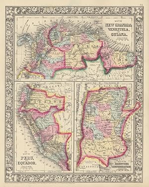
Map of New Granada, Venezuela and Guiana. Map of Peru, and Equador. Map of the Argentine Confederation.
1867 Mitchell Map of Colombia, Venezuela, Guiana, Peru, Ecuador, and Argentina
- Map
Seller: Geographicus Rare Antique Maps, Brooklyn, U.S.A.Geographicus Rare Antique Maps
Contact seller4-star sellerVery good. Blank on verso. Size 14.5 x 11 Inches. A beautiful example of the American map publisher Samuel Augustus Mitchell Jr.'s 1867 three map sheet depicting parts of South America. The first map shows New Granada (Columbia), Venezuela and Guyana. The second map, in the lower left quadrant, depicts Peru and equador (ecuador)…. The third map, in the lower right quadrant, features the Argentine Confederation. Simon Bolivar's vision of Gran Columbia was proven untenable and in 1829 and 1839, respectively, Venezuela and ecuador became independent nations leading to period of political upheaval and civil war throughout the region. Venezuela dissolved in the bloody Federal War (1859-1863) in which a significant percentage of the population perished. Colombia became the Confederación Granadina, a short lived federal republic that consisted of modern day Colombia and Panama. The Confederación, facing strong opposition from both liberal and conservative elements, dissolved in 1863 in the midst of the Colombian Civil War (1860 1862). This map also identifies various cities, towns, rivers and an assortment of additional topographical details. Map is color coded according to political boundaries with elevation rendered by hachure. One of the most attractive American atlas maps of this region to appear in the mid-19th century. Features the vine motif border typical of Mitchell maps from the 1866 - 1882 period. Prepared by S.A. Mitchell for inclusion as plate no. 61 in the 1867 issue of Mitchell's New General Atlas . Dated and copyrighted, 'entered according to Act of Congress in the Year 1867 by S. Augustus Mitchell Jr. in the Clerks Office of the District Court for the eastern District of Pennsylvania. References: Rumsey 2483.044 (1870 edition).

Johnson's Venezuela, New Granada, Ecuador, Peru & Bolivia, Chile & Guiana.
1865 Johnson Map of Venezuela, Colombia, Ecuador, Peru, Bolivia, Chile, Guiana
- Map
Seller: Geographicus Rare Antique Maps, Brooklyn, U.S.A.Geographicus Rare Antique Maps
Contact seller4-star sellerVery good. Overall toning and minor foxing. Size 13.5 x 17 Inches. This is a very attractive example of Johnson and Ward's 1865 map of the northwestern part of South America. Includes Bolivia, Peru, Ecuador, New Granada (Colombia), Venezuela, British Guiana, Surinam, French Guiana and Chile as well as adjacent portions of the Br…azil, particularly the Amazon. It offers excellent detail both along the coast and inland, especially along navigable rivers. Numerous jungle waterfalls are noted. The Amazon region is unsurprisingly vague though a few river ways and missionary stations are noted. Inset maps along the left border detail Chile and Lima. An engraved view in the lower left quadrant shows the Juan Fernandez Islands. Another inset at right center shows Valparaiso. As this map was being drawn this region was in the midst of political upheaval and civil war. Venezuela was in the midst of its bloody Federal War (1859-1863) in which a significant percentage of the population perished. Colombia was then under the Confederacion Granadina, a short-lived federal republic that consisted of modern day Colombia and Panama. The Confederacion, facing strong opposition from both liberal and conservative elements, dissolved in 1863 in the midst of the Colombian Civil War (1860 1862). This map features the strapwork style border common to Johnson's atlas work from 1860 to 1863. Published by Johnson and Ward as plate no. 65 in the 1865 edition of Johnson's Family Atlas . References: Rumsey 2905.036 (1860 edition). Phillips (Atlases) 6140-54.

- First Edition
- Map
Seller: Geographicus Rare Antique Maps, Brooklyn, U.S.A.Geographicus Rare Antique Maps
Contact seller4-star seller1st Edition. Very good. Blank on verso. Even overall toning. Size 14 x 17 Inches. An excellent 1855 first edition example of Colton's map of Peru and Bolivia. Centered on Lake Titicaca, on the Peru-Bolivia border, the map covers from ecuador to the Argentine Republic and from the Pacific to Brazil. Shows Bolivia's claims to the…Atacama Desert and Peru's claims to Moquegua - both of which are today part of Chile. An inset map of Lima, Peru, appears in the lower left quadrant. This map also identifies various cities, towns, forts, rivers, rapids, mountain passes, fords, and an assortment of additional topographical details. Map is hand colored in pink, green, yellow and blue pastels to define national and regional boundaries. Surrounded by Colton's typical spiral motif border. Dated and copyrighted to J. H. Colton, 1855. Published from Colton's 172 William Street Office in New York City. Issued as page no. 60 in volume 1 of Colton's 1856 Atlas of the World . References: Rumsey 0149.065 (1856 edition). Phillips (Atlases) 816.

Johnson's Venezuela, New Granada, Ecuador, Peru and Bolivia, Chile and Guiana.
1863 Johnson Map of Venezuela, Peru, Bolivia, Columbia and Ecuador
- Map
Seller: Geographicus Rare Antique Maps, Brooklyn, U.S.A.Geographicus Rare Antique Maps
Contact seller4-star sellerVery good. Minor overall toning. Text on verso. Size 13 x 17 Inches. This is a very attractive example of Johnson and Ward's 1863 map of the northwestern part of South America. Includes Bolivia, Peru, Ecuador, New Granada (Colombia), Venezuela, British Guiana, Surinam, French Guiana and Chile as well as adjacent portions of the…Brazil, particularly the Amazon. It offers excellent detail both along the coast and inland, especially along navigable rivers. Numerous jungle waterfalls are noted. The Amazon region is unsurprisingly vague though a few river ways and missionary stations are noted. Inset maps along the left border detail Chile and Lima. An engraved view in the lower left quadrant shows the Juan Fernandez Islands. Another inset at right center shows Valparaiso. As this map was being drawn this region was in the midst of political upheaval and civil war. Venezuela was in the midst of its bloody Federal War (1859-1863) in which a significant percentage of the population perished. Colombia was then under the Confederacion Granadina, a short lived federal republic that consisted of modern day Colombia and Panama. The Confederacion, facing strong opposition from both liberal and conservative elements, dissolved in 1863 in the midst of the Colombian Civil War (1860 1862). This map features the strapwork style border common to Johnson's atlas work from 1860 to 1863. Published by Johnson and Ward as plate no. 65 in the scarce 1863 edition of Johnson's Family Atlas . References: Rumsey 2905.036 (1860 edition). Phillips (Atlases) 6140-54.

Johnson's Venezuela, New Granada, Ecuador, Peru & Bolivia, Chile and Guiana.
1861 Johnson Map of Venezuela, Colombia, Ecuador, Peru, Bolivia, Chile, Guiana
- Map
Seller: Geographicus Rare Antique Maps, Brooklyn, U.S.A.Geographicus Rare Antique Maps
Contact seller4-star sellerVery good. Blank on verso. Size 14 x 17 Inches. A very attractive example of A. J. Johnson and R. Browning's 1861 map of the northwestern part of South America. Includes Bolivia, Peru, ecuador, New Granada (Colombia), Venezuela, British Guiana, Surinam, French Guiana and Chile as well as adjacent portions of the Brazil, particul…arly the Amazon. Offers excellent detail both along the coast and inland, especially along navigable rivers. Notes numerous jungle waterfalls. The Amazon region is unsurprisingly vague though a few river ways and missionary stations are noted. Inset maps along the left border detail Chile and Lima. An engraved view in the lower left quadrant shows the Juan Fernandez Islands. Another inset at right center shows Valparaiso. As this map was being drawn this region was in the midst of political upheaval and civil war. Venezuela was in the midst of its bloody Federal War (1859-1863) in which a significant percentage of the population perished. Colombia was then under the Confederación Granadina, a short lived federal republic that consisted of modern day Colombia and Panama. The Confederación, facing strong opposition from both liberal and conservative elements, disolved in 1863 in the midst of the Colombian Civil War (1860 1862). Features the strapwork style border common to Johnson's atlas work from 1860 to 1863. Published by A. J. Johnson and Browning as plate numbers 59-60 in the 1861 edition of Johnson's New Illustrated Family Atlas . This is the last edition of the Johnson Atlas to bear the 'Johnson and Browning' imprint. Subsequent editions reflect Ward's 1862 acquisition Ross C. Browning's shares in the firm. References: Rumsey 2905.036 (1860 edition).

- Map
Seller: Geographicus Rare Antique Maps, Brooklyn, U.S.A.Geographicus Rare Antique Maps
Contact seller4-star sellerVery good. Minor foxing and overall toning. Minor edge wear. Size 13 x 15.5 Inches. This is a beautiful 1849 map of Peru and Bolivia by S. A. Mitchell. Centered on Lake Titicaca, on the Peru-Bolivia border, this map covers the whole of both countries following the South American Wars of Independence. Bolivia at this controlled t…he Pacific coastline from Atacama to Moro de Aldan, this territory was later ceded to Chile. Political and topographical features are noted and color coded with elevation rendered by hachure. The whole is engraved and colored in Mitchell's distinctive style with green border work and vivid pastels. Mitchell published this chart in his atlas from 1846 to the late 1850s before discontinuing the series and selling his map plates to DeSilver. This map was issued in the 1849 edition of the New Universal Atlas . It was the last edition of that atlas to be published by Mitchell prior to selling the plates and rights to the atlas to Thomas Cowperthwait in 1850. References: Rumsey 0545.046.

- Map
Seller: Geographicus Rare Antique Maps, Brooklyn, U.S.A.Geographicus Rare Antique Maps
Contact seller4-star sellerVery good. Original centerfold. Platemark visible. Blank on verso. Size 13 x 9 Inches. A fine example of Rigobert Bonne and Guillaume Raynal's 1780 map of Peru. Covers from the Pacific well into the Amazon and as far south as the Aconcagua Desert. Shows Tradewinds in the pacific and shows mountains in profile. A number of import…ant indigenous villages and mission stations are noted. Highly detailed, showing towns, rivers, some topographical features, important roadways and political boundaries. Drawn by R. Bonne for G. Raynal's Atlas de Toutes les Parties Connues du Globe Terrestre, Dressé pour l'Histoire Philosophique et Politique des Établissemens et du Commerce des Européens dans les Deux Indes .

- Map
Seller: Geographicus Rare Antique Maps, Brooklyn, U.S.A.Geographicus Rare Antique Maps
Contact seller4-star sellerVery good condition. Blank on verso. Size 13 x 15 Inches. A fine example of Thomas Cowperthwait and S. A. Mitchell's 1854 map of Peru and Bolivia. The whole is engraved and colored in Mitchell's distinctive style with green border work and vivid pastels. Political and topographical features are noted and color coded with elevati…on rendered by hachure. Centered on Lake Titicaca, on the Peru-Bolivia border, this map covers the whole of both countries following the South American Wars of Independence. Bolivia at this controlled the Pacific coastline from Atacama to Moro de Aldan, this territory was later ceded to Chile. This map was prepared by S. A. Mitchell for publication by the Philadelphia firm of Thomas Cowperthwait & Co. as plate no. 43 in the 1854 edition of Mitchell's New General Atlas . Dated and copyrighted, 'Entered according to act of Congress in the year 1850 by Thomas Cowperthwait & Co. in the Clerk's office of the Eastern District of Pennsylvania. References: Rumsey 0537.042 (1846 edition). Phillips (Atlases) 814.

Partie Septentrionale du Perou, ou l'on trouve la partie occidentale du Fleuve Maragnon ou Amazone tiree de la Carte de Mr. de la Condamine. Par le Sr. Robert de Vaugondy, Fils de Mr. Robert Geogr. ordin. du Roi
1749 Vaugondy Map of Northern Peru, Ecuador, Brazil, and Colombia
- Map
Seller: Geographicus Rare Antique Maps, Brooklyn, U.S.A.Geographicus Rare Antique Maps
Contact seller4-star sellerVery good. Blank on verso. Original press mark visible. Size 7.25 x 8.5 Inches. This is a 1749 Didier Robert de Vaugondy map of northern Peru (Perou), Ecuador, Brazil, and Colombia. Depicting from Colombia to just south of Lima and from the Pacific Ocean to Brazil, the map centers on the Marañón (Maragnon) River. The Marañón is…the principal or mainstem source of the Amazon River. The map presents a highly-detailed view of the region, depicting numerous rivers and their tributaries and labeling several locations along the coastline. Countless cities are labeled, including Guayaquil, Quito, and Lima. The Equator also runs through the top portion of the map. This map was published by Gilles Robert de Vaugondy in his Atlas Universel, Portatif et Militaire in the 1749 edition. References: Pedley, M. S., Bel et Utile, p. 217, 490. OCLC 431576268.

Carte Du Perou ou se trouvent les Audiencees de Quito, Lima et la Plata.
1778 Bonne Map of Peru, Ecuador, Bolivia, and the Western Amazon
- Map
Seller: Geographicus Rare Antique Maps, Brooklyn, U.S.A.Geographicus Rare Antique Maps
Contact seller4-star sellerVery good. Some toning and wear along original centerfold. Minor foxing. Original platemark visible. Size 18 x 13 Inches. A beautiful example of Rigobert Bonne's c.1778 decorative map of Peru. Covers the western parts of South America from just north of the Equator south as far as the Tropic of Capricorn. Includes the modern day… nations of Peru, Ecuador (here called Quito), Bolivia, and parts of adjacent Brazil, Columbia, Chile and Argentina. Offers excellent detail throughout showing mountains, rivers, national boundaries, cities, regions, and tribes. Curiously, this map identifies the 'Ancienne demeure des Manaos.' This was once a great trading empire was centered along the Rio Negro in the Amazon Basin. The Manoa traded from Peru to the Orinoco. There were perhaps most famously encountered by Sir Walter Raleigh in Guyana while on an annual trading expedition to the region. Raleigh, seeing the gold artifacts carried by the traders immediately assumed they must be from El Dorado. He asked local tribesmen who they were and where they came from. The locales responded that they crossed a great lake and came from a rich land called Manoa. Though at the time Raleigh did not explore this further, he did later write that he discovered the great city of Manoa, capital of El Dorado, on a vast lake in Guyana. No doubt Raleigh intended to return to South America but was prevented from doing so by his unfortunate beheading back in England. As a result of Raleigh's guess work, the Lake of Parima and city of Manoa would appear for several hundred years on maps of northern South America. A large decorative title cartouche appears in the lower left quadrant. Drawn by R. Bonne for issue as plate no. B 34 in Jean Lattre's Atlas Moderne . References: Rumsey 2612.078. Phillips (Atlases) 664. National Maritime Museum, 215.

- Map
Seller: Geographicus Rare Antique Maps, Brooklyn, U.S.A.Geographicus Rare Antique Maps
Contact seller4-star sellerVery good. Minor wear along original centerfold. Original platemark visible. Overall toning and foxing at places. Size 25.5 x 20.5 Inches. This is a beautiful 1817 Thomson map of Peru, Chile and Argentina. It covers Bolivia, Paraguay, Uruguay and parts of Peru, Chile, Argentina and Brazil. The map identifies towns, rivers, mount…ains, indigenous groups, and other political and physical features. Names important mountains in the Andes, including Aconcagua, the largest mountain in South America. In 1821, Peru was proclaimed independent. Antonio Jose de Sucre, a Venezuelan independence leader and one of Simon Bolivar's closest friends, was given an option of either unite with the United Provinces of Rio de la Plata, stay under the newly formed Republic of Peru, or create and new nation. He chose the latter. Chile, during this time, was undergoing political upheaval and headed for civil war. After the last of the Spanish troops surrendered in 1826 and after the failure of the federalist system in 1828, Chile adopted a moderately liberal constitution. This in turn alienated both the liberal and federalist factions and would ultimately lead to the revolution in 1829 followed by 30 years of conservative governments. This map was prepared by John Thomson for inclusion in the 1817 edition of Thomson's New General Atlas . References: Rumsey 1007.077.

- Map
Seller: Geographicus Rare Antique Maps, Brooklyn, U.S.A.Geographicus Rare Antique Maps
Contact seller4-star sellerVery good. Some discoloration along fold line and in margins. Size 13 x 16 Inches. This is the Henry Teesdale / John Dower 1831 map of Peru and Bolivia published in A New General Atlas of the World . It depicts the titular countries and their neighbors as they emerged from Spanish rule and contended with internal and external co…nflicts over borders, social structures, and systems of government. Historical Context This map was published in the years after Peru, Bolivia, and other South American republics won their independence, following a long and difficult conflict with the Spanish crown. But the constitution of the new republics, their political representation, and their borders were far from fixed, leading to further conflict. Just three years before this map's publication, Peru fought a border war against Bolivia, a prelude to a larger war with Colombia (Gran Colombia), which resulted in the latter state's dissolution and the dramatic fall of Simón Bolívar. In the late 1830s, attempts were made to unite Peru and Bolivia through both peaceful and forceful means. In the late 1870s, the two former rivals teamed up in yet another border dispute against Chile. The present-day borders differ somewhat from what is illustrated here. For instance, Bolivia's border with Peru now runs through and to either side of Lake Titicaca (Chucuito), while the border between Peru and Chile now sits between Tacna and Arica, both part of Peru here. Domestic politics were just as contentious, with uncertainty over the system of government to be adopted, the relative strength of different branches of government, the role of the military, and the social groups whose interests the government would represent. Indigenous (Indian) communities, who composed most of the population in Bolivia and certain areas of Peru, were at best neglected and at worst oppressed by the new republics, despite the hopes of Bolívar to improve their lot. Neighboring countries went through similar transformations; 'La Plata' at bottom refers to the United Provinces of the Río de la Plata, the confederation that Bolivia had earlier belonged to, and whose remnant parts merged the same year as this map's publication to form Argentina. Publication History and Census This map was engraved by John Dower for the 1831 edition of A New General Atlas of the World , published by Henry Teesdale. This appears to be an especially rare presentation of Dower's Peru and Bolivia map, not matching any of the examples in the David Rumsey Historical Map Collection or other major digital repositories. Although undated, based on contextual evidence (such as the inclusion of La Plata), it almost certainly is an example from 1831. The map is only cataloged in the holdings of five institutions, though as stated above the present map is likely to be distinct from those examples in coloration and presentation. References: OCLC 43221802.

- Map
Seller: Geographicus Rare Antique Maps, Brooklyn, U.S.A.Geographicus Rare Antique Maps
Contact seller4-star sellerVery good. Size 17.5 x 24.625 Inches. This is a c. 1975 pictorial tourist map of Arequipa, one of Peru's most beautiful and historic cities. Pictorial vignettes highlight important buildings throughout central Arequipa, including the cathedral, the Plaza de San Francisco, the Banco Central de Reserva (Central Reserve Bank), and…the Parque Duhamel. Hotels, banks, restaurants, and other businesses are identified as well. Numerous airline offices, including Aire France, Aerolineas Argentinas, and Lufthansa are also labeled. A stunning pictorial border encircles the map on three sides highlighting the Andes, bullfighting, and hotels. Arequipa Arequipa was founded on August 15, 1540, and formally named by Spanish king Carlos on September 22, 1541. Arequipa held an outstanding economic position during the viceregal period. During the Republican Era, Arequipa has seen civic, popular, and democratic rebellions. Today, Arequipa is the second most populous city in Peru and the seat of the Constitutional Court, for which it is known as the 'legal capital of Peru'. Its historical center, some of which is illustrated here, has been declared a UNESCO World Heritage Site. Publication History and Census This map was approved by the Concejo Provincial de Arequipa (Arequipa Provincial Council) with input from the Ministerio de Industria y Turismo (Ministry of Industry and Tourism). It was printed in Arequipo by Cuzzi y Cia. c. 1975. An example bearing the same title is cataloged in OCLC as part of the collection at the University of Amsterdam. References: OCLC 71576909.

- First Edition
- Map
Seller: Geographicus Rare Antique Maps, Brooklyn, U.S.A.Geographicus Rare Antique Maps
Contact seller4-star seller1st Edition. Very good. Minor foxing. Original platemark visible. Size 13.5 x 11.5 Inches. This is a good example of the 1833 first edition map of Peru and Bolivia by David H. Burr. It covers all of Peru and Bolivia. Bolivia's claims to the Atacama Desert and Peru's claims to the Tarapaca region - both of which are today part of… Chile, are shown here. Towns, rivers, mountains, lakes and other topographical features are noted. Elevation is rendered by hachure and political and regional territories are color-coded. In 1836, shortly after this map was prepared, the Peru-Bolivian Confederation came into existence. The Confederation proved ephemeral, collapsing in 1839 following the War of the Confederation, a conflict between Chile, Peruvian rebels, and Argentina against the Peru-Bolivian Confederation. According to Ristow, although Burr is credited on the title page, he left this atlas incomplete. He was appointed as topographer to the U.S. Post Office, and of the sixty-three maps finally included in this atlas, only completed eight. The rest of the maps were then completed by Illman and Pilbrow in Burr's style. This map was 'Entered according to act of Congress in the year 1833 by Illman and Pilbrow in the Clerk's office of the District Court for the Southern District of New York', but was not published until the atlas was released in 1835. Published by D. S. Stone in Burr's New Universal Atlas . References: Rumsey 4628.061. Philips (Atlases) 771.

- Map
Seller: Geographicus Rare Antique Maps, Brooklyn, U.S.A.Geographicus Rare Antique Maps
Contact seller4-star sellerVery good. Even overall toning. Verso reinforcement along original centerfold. Blank on verso. Size 15.25 x 19.5 Inches. This is a c. 1700 Pieter Schenk and Gerard Valk map of Peru. The map, oriented towards the east, depicts the region from Los Pastos to Val Xuxuy and from an area east of Peru along the Omapalchas River and hom…e to the Marquires and Cheriabonas Indians to the Pacific Ocean. Highly detailed, myriad cities, towns, and villages are labeled, along with the names of numerous Indian tribes native to the region. Lake Titicaca is prominently illustrated, as are the Andes, which extend along the length of Peru. Intriguingly, as the map progresses further and further to the east, into the Amazon, the map become blank, indicating the complete lack of knowledge about the region. Beautiful sailing ships are included in the Pacific, close to a ghastly sea monster. A decorative cartouche bearing the map's title and scale is situated in the upper left corner. This map was published by Pieter Schenk and Gerard Valk c. 1700. This map was originally published by Hondius, whose plates were acquired by Schenk and Valk in 1694. References: Koeman 9820:1. OCLC 166645035.

- Map
Seller: Geographicus Rare Antique Maps, Brooklyn, U.S.A.Geographicus Rare Antique Maps
Contact seller4-star sellerVery good. Surface wear and minor chipping of top layerinmargins. Size 19.25 x 27.5 Inches. A charming c. 1954 pictorial map of Lima, Peru. lllustrations by R. Fiol present the city's impressive architecture and lively culture. A Closer Look Oriented towards the south, this map illustrates grand government buildings, statues, ch…urches, and other landmarks throughout. These are interspersed with representations of leisure activities, such as cockfighting, horse racing, theaters, live music, and a bullfighting ring. Some neighborhoods are also represented, such as the figure in Chinese dress next to the Mercado Central, who represents the Barrio Chino. Rebuilding Lima Lima as seen here was largely the product of the early 20th century, as the city recovered from the upheavals of the 1879-1883 War of the Pacific, which saw unrest, occupation, and widespread destruction. Lima grew rapidly in the mid-20th century with an influx of migrants from elsewhere in Peru, especially indigenous peoples from the interior. Populist governments instituted urban renewal and public works projects, resulting in impressive new buildings, such as the Ministerio de Educación and Hospital del Empleado buildings seen here. Publication History and Census This map was drawn by 'R. Fiol' and printed by Offset Iberia Lima, most likely in 1954 or later, as suggested by the large and distinctive Ministry of Education building (now the Javier Alzamora Valdez Building), which opened in 1954, at center towards left. No information is available on the artist, and little about Offset Iberia Lima aside from this map and another, more conventional city plan of Lima published in 1957. The present map is not cataloged in any institutional collections and has only appeared on the market once in recent years.

- Map
Seller: Geographicus Rare Antique Maps, Brooklyn, U.S.A.Geographicus Rare Antique Maps
Contact seller4-star sellerVery good. Platemark visible. Size 18 x 20.5 Inches. This is an 1827 German edition of Matthew Carey and Isaac Lea's map of Peru, published in Weimar by the Geographischen Instituts. It is an early map, among the first in German, of Peru following its independence, which had only been secured the previous year. A Closer Look Thi…s map outlines the provinces of newly independent Peru, as well as features in neighboring territories. The Andes, indicated by hachures, predominate, while towns and cities, waterways, islands, coastal features, and borders between provinces and countries are depicted in great detail. A large 'unknown area' in the Amazon indicates that much of the interior of the continent remained unmapped. Although based on the sheet of Peru in Carey and Lea's American Atlas , this is not an exact, one-to-one transposition of text from the English edition. In some places, the text very neatly matches, while elsewhere information is combined, condensed, or arranged differently (such as the population statistics at left, which appear as a table in the American Atlas ). The scale is changed to geographic miles, but Washington D.C. is maintained as the Prime Meridian. It is worth noting that interest in South America throughout Europe (but especially in the German-speaking world) was elevated in the years preceding this map's publication due to the popular works of the naturalist and geographer Alexander von Humboldt, who traveled throughout the region in the early 19th century. Publication History and Census This map originally appeared in the 1822 edition of Matthew Carey and Isaac Lea's A Complete, Historical, Chronological, and Geographical American Atlas , and was republished in the 1827 edition of the atlas with text reflecting the country's secured independence. It was then translated into German, with the text modified slightly, by the Geographischen Instituts in Weimar. It is not listed among any institutional collections in OCLC, while an Atlas von Amerika (with Carl Weiland listed as author) from which it was likely derived is held by the Württembergische Landesbibliothek. References: OCLC 1046548091 (entire atlas).

The Port of Santa. / Pacasmayo Roads.
1826 Manuscript Map: HMS Mersey's Anchorages at Isla Santa and Pacasmayo, Peru
- Map
Seller: Geographicus Rare Antique Maps, Brooklyn, U.S.A.Geographicus Rare Antique Maps
Contact seller4-star sellerPoor. Manuscript pen and ink, Several marginal tears , one with some loss of border. Areas of staining. Size 8 x 14.25 Inches. These two c. 1927 manuscript maps, drawn on a single sheet, detail anchorages along the coast of Peru: one of the Island of Santa and the approaches to Pacasmayo. They were taken from the 1824-27 voyage…of HMS Mersey during the ship's tenure in South America and were likely the work of either her Captain or her Master. A Closer Look The sheet contains two separate charts: The Port of Santa and the Pacasmayo Roads . Both appear off the coast of Peru, at approximately 9° and 7° S. latitude, respectively; both charts are oriented to the east. The Port of Santa is the larger of the two. The title, latitude, longitude, and magnetic variation are neatly presented in a simple box cartouche with a scale of miles below. A simple compass rose appears at the lower right. The Island of Santa is drawn near the center; between it and the point now known as Infiernillo , a triangle of depth soundings appears. Four good anchorages are noted, one of which is labeled HMS Mersey . Much of the coastline is indefinite, marked with a dotted line and labeled 'surf'. A point near the site of present-day Puerto Santa is marked 'best landing.' The mouth of the River Santa is marked, along with a good watering place. No settlement is shown, but just north of present-day Santo, ruins are marked. For Pacasmayo Roads , the draftsman has sketched in the coast with a dotted line. Two anchorages are noted amongst two courses of depth soundings. Pacasmayo point is identified, and village is sketched in, with a few neatly penned trees added. A scale of miles is drawn in the lower right; the title, latitude, and longitude appear in a neat box in the upper left. At the bottom is a half compass rose, with a notation of the magnetic variation. The Author These two charts are best attributed to the Master of HMS Mersey , John Bremner, or her Captain, John MacPherson Ferguson. Bremner is the more likely candidate; he was the author of a printed work, 'Sketch of the Bay of Santa and Port Samanca on the Coast of Peru 1826'. Ferguson's and Bremner's observations, but not these charts, were also captured in print in the Admiralty publication Memoir on The Navigation of South America, to Accompany a Chart of That Station . (Though the Memoir had a publication date of 1825, it contained updates as late as 1828.) Ferguson's text in the Memoir agrees with these charts in terms of position, depth soundings, and location details. Publication History and Census This manuscript was drawn, probably by ship's Master John Bremner, no later than 1828 but likely in the vicinity of 1826 during HMS Mersey 's posting off South America. A handful of Bremner's manuscripts survive in British archives, but we are not aware of any that have reached the market. We are aware of only one printed chart with his name attached (see above), but we identify only a single example of it in institutional collections. The present work, being a manuscript draught, is one of a kind.

- Map
Seller: Geographicus Rare Antique Maps, Brooklyn, U.S.A.Geographicus Rare Antique Maps
Contact seller4-star sellerGood. Varnished leading to overall yellowing. Some cracking. Hand color. Dampstaining. Size 23 x 21 Inches. A rare and mysterious 1947 map of Peru by the artist Pierre Hébrard. Stylistically playing on maps of the Dutch Golden Age, it also employs etching and bright, brilliant colors to represent the lushness of the Peruvian int…erior. A Closer Look The map represents Peru in the mid-late 16th century, after the conquests of Pizarro and the establishment of fortified towns by various conquistadores. Cities and towns (or, perhaps more accurately, Catholic parishes) are labelled throughout, with Cusco near center, and Lima along the coast at left-center. Some of the places indicated either no longer exist or have been renamed, while others now use modern Spanish spellings that differ slightly (for example, Trugillo here is now Trujillo). Elsewhere, the map anachronistically inserts modern placenames, as with Ayacucho (rather than its 16th century name, Huamanga). The text at bottom, within the vignette illustration, reads 'adaptation des anciennes cartes français du Pérou dessinée et gravée par Pierre Hébrard.' It is unclear to which maps specifically Hébrard is referring. The flourishes on the map, such as the ships, sea monsters, and cartes-à-figures, are all reminiscent of works of the Dutch 'Golden Age'. Publication History and Census This map was drawn and engraved (etched) by Pierre Hébrard in Paris in 1947. It appears to be an etching, perhaps with some elements (such as the coastal waves) engraved, a curious choice that reflects the creator's inclination towards aesthetic quality over ease of production. No additional information about the map's artist or publication is available. A note in pencil at bottom suggests the map was produced in a limited run of 350, of which the present example was number 37; a signature nearby may have been the original owner. There are no other known examples of this map in institutional collections or on the market.


