
Order Total (1 Item Items):
Shipping Destination:

Peyrounin Abraham (7 results)
Skip to main search results
Search filters
Product Type
- All Product Types
- Books (5)
- Magazines & Periodicals (No further results match this refinement)
- Comics (No further results match this refinement)
- Sheet Music (No further results match this refinement)
- Art, Prints & Posters (2)
- Photographs (No further results match this refinement)
- Maps (No further results match this refinement)
- Manuscripts & Paper Collectibles (No further results match this refinement)
Condition Learn more
- New (No further results match this refinement)
- As New, Fine or Near Fine (No further results match this refinement)
- Very Good or Good (3)
- Fair or Poor (1)
- As Described (3)
Binding
- All Bindings
- Hardcover (No further results match this refinement)
- Softcover (No further results match this refinement)
Collectible Attributes
- First Edition (No further results match this refinement)
- Signed (No further results match this refinement)
- Dust Jacket (No further results match this refinement)
- Seller-Supplied Images (7)
- Not Print on Demand (7)
Language (1)
Price
- Any Price
- Under US$ 25 (No further results match this refinement)
- US$ 25 to US$ 50 (No further results match this refinement)
- Over US$ 50
Free Shipping
- Free Shipping to U.S.A. (No further results match this refinement)
Seller Location
Seller Rating
-

Palestinae Sive Terrae Sanctae que et Promissionis Nova Tabula ad ss. Bibliorum Intelligentiam Delineata, ex Christiano Adrichomio collecta. -
Published by Paris: Mariette., 1646
Seller: Antiquariat Tautenhahn, L�beck, Germany
Association Member: GIAQ ILAB VDA
Seller rating 5 out of 5 stars

Art / Print / Poster
Grenzkolorierter Kupferstich 40,5 x 54 cm, Blattgr��e 43,5 x 59 cm. Die nicht genordete Karte zeigt in der oberen Bildh�lfte das Gebiet des heiligen Landes links den See Genezareth, mittig das Tote Meer und rechts das Rote Meer. Unten rechts die K�ste von �gypten, unten links eine Nebenkarte von Syrien. Der Titel �ber dem Bild, unten im Bild ein Meilenanzeiger sowie die Namen von Stecher und Verleger. - Christian Adrichomio, auch Christian von Adrichem, 1533-1585, r�mischer Priester und Autor.- Das Papier leicht gebr�unt und angestaubt, ein Fleck in der rechten Blatth�lfte. Mittig gefaltet, dort ist das Papier recht d�nn, am oberen Rand in der Mitte Papierausriss bis in die Umrandung hinein. Trotz der benannten M�ngel eine sch�ne Karte.
-
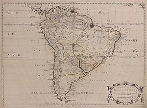
Amerique Meridionale
Published by Pierre Mariette, Paris, 1650
Seller: Argosy Book Store, ABAA, ILAB, New York, NY, U.S.A.
Seller rating 5 out of 5 stars
unbound. Abraham Peyrounin (illustrator). Map. Engraving with original outline color. Image measures 15 3/4" x 21 3/4" This exceptionally fine map of South America covers the continent in fine detail. Coastlines are extensively labeled, and mountains beautifully rendered in profile. The Orinoco and Amazon Rivers, as well as Rio de la Plata, are prominently rendered. Sanson refrains from drawing a southern coastline to Tierra del Fuego, and the relatively unknown Amazon region is depicted in minimal detail. Sanson does, however, include the mythical lake "Lac de Parime", and the city of gold "Manoa del Dora" between the Orinoco and Amazon rivers. Nice dark impression. In very good condition. Minor dampstain to lower margin not affecting the image, and some faint stains near the center of the map - otherwise clean and bright. Hard to find. Nicolas Sanson (1600-1667) is considered the founder of the French school of cartography. In reaction to the prevailing trend of Dutch lavishness, Sanson favored minimal details, focusing rather on accurate cartography than ornament.
-
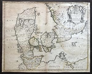
Carte generalle du Royaume de Danemarc.
Publication Date: 1646
Seller: BOTTEGHINA D'ARTE GALLERIA K�PROS, Rosignano Solvay, LI, Italy
Seller rating 2 out of 5 stars

Art / Print / Poster
No legatura. Condition: Discreto. Paris, Pierre Mariette, Rue S. Jacques a l'Esperance, 1646. Incisione in rame all'acquaforte, confini in colore d'epoca, in basso a destra, in lastra, "A. Peyrounin fecit 1646". La carta � anteriore a quella di Pierre Du Val che reca il titolo "Carte du Royaume de Danemarq, et de la partie Meridionale de la Gotie", del 1686. Abraham Peyrounin (1620 1666 circa), incisore francese attivo a Parigi durante la met� del XVII secolo. Della sua vita poco sappiamo e il suo nome resta legato a quello dei pi� noti Nicolas Sanson e Pierre Mariette, con i quali collabor� per la realizzazione di carte e mappe. Non comune. Esemplare stampato su carta fine, rifilato ai margini ma con presente la battuta della lastra, una mancanza reintegrata all'angolo superiore destro (ora reintegrato), buono l'inciso. .
-
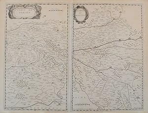
Map of Centre-Val de Loire and Normandy
Publication Date: 1650
Seller: The Online Portrait Gallery, Den Haag, Netherlands
Seller rating 5 out of 5 stars
No Binding. Condition: Reasonable. Carte Du Perche. A rare map of the former provinces Perche and Blesois. Etching and Engraving by Abraham Peyrounin (c. 1620 - c. 1666), c. 1650. Source: Published in Paris by Pierre Mariette, c. 1650. Reasonable condition. Centrefold as issued. Paper a bit browned. Some minor staining along the upper edge (=not affecting the map). Margins a bit short. Some minor creasing. Verso: blank. Note: with one other map "Carte Du Blaisois". Dimensions: 385 x 498 mm. c. 1650. Print.
-

Map of Occitanie
Publication Date: 1650
Seller: The Online Portrait Gallery, Den Haag, Netherlands
Seller rating 5 out of 5 stars
No Binding. Condition: Good. Carte du Querci. A rare and early map of Quercy, with its capital Cahors in the middle of the map. Title in a simple cartouche in the upper right corner. Etching and Engraving by Abraham Peyrounin (c. 1620 - c. 1666), c. 1650. Source: Published in Paris by Pierre Mariette, c. 1650. Good condition. Centrefold as issued. Some minor browning along edges. Verso: blank. Dimensions: 372 x 484 mm. c. 1650. Print.
-

Map of Paris
Publication Date: 1650
Seller: The Online Portrait Gallery, Den Haag, Netherlands
Seller rating 5 out of 5 stars
No Binding. Condition: Good. Diocese Prevoste Et Eslection De Paris (.). A map of the Diocese of Paris. The title in a decorative cartouche. In an attractive, but later handcolouring. Copper Engraving by Abraham Peyrounin (c. 1620 - c. 1666), c. 1650. Source: Published in Paris by Pierre Mariette and Nicolas Sanson, c. 1650. Good, repaired condition. Paper expertly cleaned and flattenend. Verso: blank. Dimensions: 407 x 542 mm. c. 1650. Print.
-

Map of Hauts-de-France
Publication Date: 1640
Seller: The Online Portrait Gallery, Den Haag, Netherlands
Seller rating 5 out of 5 stars
No Binding. Condition: Good. Carte Des Comtes D'Artois Et Boulenois. A rare, early map of Artois and Boulonnais by Pierre Duval. Title in a decorative cartouche. Copper Engraving by Abraham Peyrounin (c. 1620 - c. 1666), c. 1640. Source: Published in Paris by Pierre Mariette, c. 1640. Good condition. Centrefold as issued. Paper a bit browned, mainly in the margins. Some minor creasing. Verso: blank. Dimensions: 379 x 495 mm. c. 1640. Print.