
Order Total (1 Item Items):
Shipping Destination:

Pre Colonial Map (1 results)
Skip to main search results
Search filters
Product Type
- All Product Types
- Books (1)
- Magazines & Periodicals (No further results match this refinement)
- Comics (No further results match this refinement)
- Sheet Music (No further results match this refinement)
- Art, Prints & Posters (No further results match this refinement)
- Photographs (No further results match this refinement)
- Maps (No further results match this refinement)
- Manuscripts & Paper Collectibles (No further results match this refinement)
Condition Learn more
- New (No further results match this refinement)
- As New, Fine or Near Fine (No further results match this refinement)
- Very Good or Good (No further results match this refinement)
- Fair or Poor (No further results match this refinement)
- As Described (1)
Binding
- All Bindings
- Hardcover (No further results match this refinement)
- Softcover (No further results match this refinement)
Collectible Attributes
- First Edition (No further results match this refinement)
- Signed (No further results match this refinement)
- Dust Jacket (No further results match this refinement)
- Seller-Supplied Images (1)
- Not Print on Demand (1)
Language (1)
Price
- Any Price
- Under US$ 25 (No further results match this refinement)
- US$ 25 to US$ 50 (No further results match this refinement)
- Over US$ 50
Free Shipping
- Free Shipping to U.S.A. (No further results match this refinement)
Seller Location
Seller Rating
-
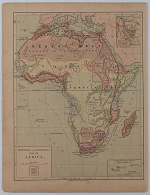
Physical and Political Map of Africa.
Published by Harper & Brothers. [circa1877]., New York., 1877
Seller: Asia Bookroom ANZAAB/ILAB, Canberra, ACT, Australia
Association Member: ANZAAB ILAB
Seller rating 5 out of 5 stars

Chromolithographed map with outlne handcolour, 27.1 x 21 cm, major towns marked with a red cross, relief by hachures, ocean currents marked, two inset maps of the Suez canal and Mascarene Island, two very small marginal edge tears not affecting the map, slight toning, unrelated text on the verso, prepared for "Harper's School Geography", in very good condition Interesting map of Africa before the escalation of the European race for colonial possessions from 1880. The map shows: the European possessions of the Cape Colony, Transvaal Republic, Orange River Republic, and Natal; regions of the continent as fertile belts and desert belts; and indicates agricultural and other production such as palm oil, ivory, skins, and cattle. Major cities are shown, with important trade centers highlighted with a red cross. Prepared for US students in "Harper's School Geography", longitude is shown from the Greenwich prime meridian at the head of the map, and from the Washington prime meridian at the foot. A small outline map of Ohio is included for relative scale.