Pre Partition (1 results)
 More images
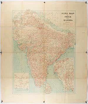
Published by Joshi & Co. circa1940., Bombay. 1940
Seller: Asia Bookroom ANZAAB/ILAB, Canberra, ACT, AustraliaAsia Bookroom ANZAAB/ILAB
Contact seller5-star sellerCondition: Used
US$ 307.22
US$ 21.25 shippingShips from Australia to U.S.A.Quantity: 1 available
Colour lithographic map, 66 x 50 cms; 81.x 68.5 cms (sheet), two inset maps and on the verso a full sheet "Relief Map of India", original folds, with fold splits (archivally strengthened), several city names have been neatly underlined, ?Agartala? inked in the margin, overall in good condition. Scarce Bombay-published map of the… pre-Partition Indian sub-continent with two small inset maps one showing roads around Karachi and the other Burma. Through Routes, Other Main Roads, and Motorable Roads Subject to Weather are marked. The "Relief Map of India" on the verso includes Railway Lines, Canals, Steamer Routes, Rivers, Air Routes, Navigable Canals, and Broadcasting Stations.
