Order Total (1 Item Items):
Shipping Destination:

Radefeld (129 results)
Author:
radefeld
Refine with Advanced Search
Skip to main search results
Search filters
Product Type
- All Product Types
- Books (38)
- Magazines & Periodicals (No further results match this refinement)
- Comics (No further results match this refinement)
- Sheet Music (No further results match this refinement)
- Art, Prints & Posters (4)
- Photographs (No further results match this refinement)
- Maps (86)
- Manuscripts & Paper Collectibles (1)
Condition Learn more
- New (15)
- As New, Fine or Near Fine (18)
- Very Good or Good (16)
- Fair or Poor (No further results match this refinement)
- As Described (80)
Binding
Collectible Attributes
- First Edition (16)
- Signed (11)
- Dust Jacket (No further results match this refinement)
- Seller-Supplied Images (115)
- Not Print on Demand (116)
Language (3)
Free Shipping
Seller Location
Seller Rating
-

4 Ansichten (Gastwirtschaft M.Dietrich, Dorfstrasse, Schule, Kirche). Ansichtskarte in Photodruck. Ungelaufen.
Language: German
Published by Leipzig, Wernicke, um 1930., 1930
Manuscript / Paper Collectible
9,0 x 14,0 cm. Die Portokosten betragen im Inland 1,00 Euro. [SW - Postkarte, Postkarten, Ansichtskarte].
-

meyers reiseb�cher - 13. auflage Gewicht in Gramm: 550 r�cken etwas geklebt,einband berieben,innen sauber.
-

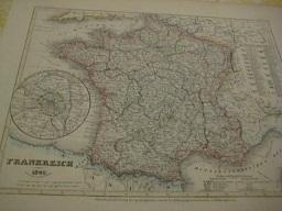
Frankreich. 1855. Stahlstichkarte mit Grenzkolorit. Entworfen u. gez. v. Radefeld. Revidirt 1856.
Published by Hildburghausen: Bibliographisches Institut ff, 1857
Blattgr��e: 29,5:23,5 cm. Bildgr��e: 25,2:18,8 cm. Unter Passepartout. - Mit einem Nebenk�rtchen: Gegend von Paris. In der Mitte gefaltet, Aus: Meyers Zeitungs-Atlas.
-

�ber den spezifischen Unterschied des Christianismus vom Naturalismus,: zur Beurteilung einer Neuerung, welche mit dem Christennamen im Werke ist (German Edition)
Seller: Ria Christie Collections, Uxbridge, United Kingdom
Seller rating 5 out of 5 stars

US$ 22.93
US$ 16.05 shipping
Ships from United Kingdom to U.S.A.Quantity: Over 20 available
Add to basketCondition: New. In.
-

Grenzkolorierte Karte aus Meyer s Groschen-Atlas.
Published by Hildburghausen. Bibliographisches Institut 1852., 1852
Seller: Antiquariat Bernd Pre�ler, Ahnatal Weimar, Germany
Seller rating 5 out of 5 stars
Altersgem�� tadelloses Blatt. (27 x 31, 5 cm au�en). Kein Versand aufgrund von EPR Regelungen in EU-L�nder au�erhalb Deutschlands. No shipping to EU countries outside of Germany due to EPR regulations.
-
Zw�lfte Auflage. 276 Seiten. Mit 14 Karten, 4 Pl�nen und 1 Panorama. OKart. Ordnungsgem�� aus einer Universit�ts-Bibliothek ausgesondert (Stempel, Signatur). Sauberes, gut erhaltenes Exemplar. Sprache: Deutsch Gewicht in Gramm: 202.
-

Neueste Karte von Nubien, Habesch, Kordofan und Darfur. No. 48.
Published by Bibliographisches Institut, Hildburghausen Amsterdam Paris Philadelphia, 1844
Map
Condition: Befriedigend. Stahlstichkarte mit Grenzkolorit von Hauptmann Radefeld aus J. Meyer's Hand-Atlas. Das Blatt hat am oberen Rand deutliche Randl�suren und tr�gt einen handschriftl. Zahlenvermerk rechts oben. Sprache / Language: de 1 Seiten. ca. 36,7 x 45,8 cm.
-
Grossherzogthum Oldenburg - F�rstenthum L�beck - F�rstenthum Birkenfeld
Published by Biographischen Institut Hildburghausen, 1862
Map
Kein Einband. Condition: Befriedigend. Ma�stab 1:650000, Gebrauchs- und Alterspuren, gefaltet, an der Falz kleine Einrisse, altersgebr�unt Size: 24x30 cm. Karte.
-

"Der Grosse Ocean und Australien" - Australien Australia Pacific Ocean America Russia map carte Karte
Language: German
Published by Hildburghausen, 1849
Seller: Antiquariat Steffen V�lkel GmbH, Seubersdorf, Germany
Seller rating 5 out of 5 stars
Map
Original altkolorierte Stahlstich-Karte von 1849. -- Blattmasse ca.25,5 x31,5cm. -- gut erhalten.|| Original old colored engraved map from 1849. -- in good condition. || Dies ist ein Original! - Kein Nachdruck! - Keine Kopie! -- This is an original! - No copy! - No reprint! // Wir, das Antiquariat Steffen V�lkel, kaufen und verkaufen alte B�cher, Handschriften, Zeichnungen, Autographen, Grafiken und Fotografien. Wir sind stets am Ankauf von kompletten Bibliotheken, Sammlungen und Nachl�ssen interessiert. Sprache: Deutsch Gewicht in Gramm: 1550.
-
Meyers Reiseb�cher. TH�RINGEN.
Language: German
Published by Leipzig und Wien, Bibliographisches Institut,, 1898
Seller: Antiquariat am Ungererbad-Wilfrid Robin, M�nchen, Germany
Seller rating 5 out of 5 stars
Condition: Gut. Bll. + 272 S., inkl. Register + 21 S. Anzeiger zum Th�ringer Wegweiser (14. Jahrg. 1899/1900) u. mit 14 Karten, 7 Pl�nen und 1 Panorama. Papier minimal nach- oder randgebr�unt. Sprache: Deutsch Gewicht in Gramm: 220 Kl.-8�, Or.-HalbLnw. (Bordeaux-Rot), mit Titelung. Kl. Alters- u. Gebrauchsspuren. Gutes Exemplar. Vierzehnte Auflage, bearbeitet unter mitwirkung des Th�ringerwald-Vereins.
-

Das K�nigreich Bayern. N�rdliche H�lfte Entw. u. gez. v. Major Radefeld
Published by Bibliograph. Institut 1845-1855, Hildburghausen, 1845
Seller: Antiquariat Reinhold Berg eK Inh. R.Berg, Regensburg, Germany
Seller rating 5 out of 5 stars
Map
Steel engraving, hand colored in outline when published. Die Karte zeigt das Gebiet von Erfurt im Norden bis Regensburg im S�den. Frankfurt im Westen und Zwiesel im Osten. In excellent condition. 193 by 280mm (7� by 11 inches).
-

Australia: Neueste Karte Von Australien, 1846
Language: English
Publication Date: 1846
US$ 48.29
US$ 33.49 shipping
Ships from United Kingdom to U.S.A.Quantity: 1 available
Add to basketNo Binding. Condition: Very Good. Date: 1846. Original steel engraving. Sheet size: 43.2cm x 36.2cm. A detailed map of the South Pacific with inset maps of New South Wales, Van Diemen's Land and Western Australia. Blank to the reverse. Contemporary outline hand-colouring. Minor age toning which is mainly confined to the margins. A very good indeed, bright, clean copy. SR: Sleeve: 1111 Map Drawer D.
-

Die Gro�herzogth�mer Mecklenburg-Schwerin und Mecklenburg-Strelitz. Ma�stab 1:625 000. Aus Meyer's Handatlas.
Published by Bibliographisches Institut, Hildburghausen, 1862
Map
Condition: Befriedigend. Brief/Blatt/Landkarte Grenzkolorierte Stahlstichkarte der Gro�herzogt�mer Mecklenburg aus Meyer's Handatlas, entworfen von Major Radefeld in der Revision von L. Ravenstein. Mit einer Einschaltkarte Plan von Schwerin. Das Blatt ist teilw. etwas randrissig, an den R�ndern verschmutzt, am unteren Eck rechts stark fingerfleckig. Sprache / Language: de 1 Seiten. ca. 36,5 x 47 cm.
-
MAP: GROSSBRITANNIEN UND IRELAND (GREAT BRITAIN AND IRELAND)
Published by Bibliographischen Instituts Hildburghausen, Germany, 1844
Seller: Luis Porretta Fine Arts, Nanaimo RPO Country Club, BC, Canada
Seller rating 3 out of 5 stars

Non-Book. Condition: Very Good. Dust Jacket Condition: No Dust Jacket. This engraved map is a little foxed, edges chipped, later hand coloring, fine detail. An interesting and seldom seen map. Country boundaries hand col. Relief shown by hachures. Shows ship and railroad routes, etc. ; 14" x 17".
-
Orig. Landkarte "Frankreich 1849"
Language: German
Published by Hildburghausen, Bibliographisches Institut,, 1849
4�, Broschiert. Original Landkarte "Frankreich 1849" v. Hptm. Radefeld, hrsg. Bibliographisches Institut, Hildburghausen, o.J., Blattgr��e ca. 31 x 26,5 guter-sehr guter Zustand. Sprache: Deutsch Gewicht in Gramm: 750.
-

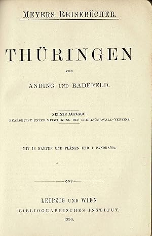
Th�ringen. Bearbeitet unter Mitwirkung des Th�ringerwald-Vereins.
Language: German
Published by Leipzig, Bibliographisches Institut,, 1890
10. Auflage. X, 1 Blatt, 271 Seiten, 16 Seiten Anzeigen, Mit 16 Karten und Pl�nen und einem Panorama. Neben-Untertitel: "Wegweiser Th�ringen". Der R�cken mit Abklatsch der rostigen Klammern, beide Einbanddeckel mit Knickspuren l�ngs und mit schwachen Schabstellen, wenige Eselsohren. Insgesamt aber durchaus ordentliches und sauberes, vor allem aber vollst�ndiges Exemplar Sprache: Deutsch Gewicht in Gramm: 258 Original-Halbleinen, 10x15cm, Zustand: 3.
-

England Bergzeichnung v. Hauptm Radefeld. 1852.
Published by Bibliograph. Institut, Hildburghausen, 1852
Seller: Antiquariat Reinhold Berg eK Inh. R.Berg, Regensburg, Germany
Seller rating 5 out of 5 stars
Map
Other. Steel engraving, handcolored in outline, when published. Small and decorative map of England, showing many place names, rivers, mountains, streets and railroads. In excellent condition. 265 by 215mm (10� by 8� inches). 265 by 215mm (10� by 8� inches).
-
"Neuste Karte von Salzburg. Entw. u. gez. v. Hauptm. Radefeld". Aus: Meyer's Hand-Atlas.
Published by Hildburghausen, Bibliographisches Institut. 1843., 1843
Seller: Antiquariat MEINDL & SULZMANN OG, Wien - Vienna, Austria
Seller rating 5 out of 5 stars
Blattgr��e ca. 34 x 42 cm. Bildausschnitt ca. 29 x 35,5 cm.
-

Frankreich 1845 - Entw. u. gez. v. Hauptmann Radefeld.
Published by Bibliograph. Institut, Hildburghausen, 1845
Seller: Antiquariat Reinhold Berg eK Inh. R.Berg, Regensburg, Germany
Seller rating 5 out of 5 stars
Map
Other. Steel engraving, hand colored in outline. Still in good condition. 293 by 359mm (11� by 14� inches). 293 by 359mm (11� by 14� inches).
-

Taschenbuch. Condition: Neu. �ber den spezifischen Unterschied des Christianismus vom Naturalismus, | zur Beurteilung einer Neuerung, welche mit dem Christennamen im Werke ist | Johann Radefeld | Taschenbuch | 60 S. | Deutsch | 2017 | hansebooks | EAN 9783743437654 | Verantwortliche Person f�r die EU: Hansebooks GmbH, Trakehner Weg 52, 22844 Norderstedt, gb[at]hansebooks[dot]com | Anbieter: preigu.
-
Th�ringen.
Published by Leipzig und Wien: Bibliographisches Institut, 1896
Seller: ANTIQUARIAT B�CHERBERG Martin Walkner, Salzburg, Austria
Seller rating 5 out of 5 stars
13. Auflage. XI+300+24 S. mit 15 Karten, 6 Pl�nen (teils gefaltet) und 1 Falt-Panorama (Inselsberg). Rotes Halbleinen, Klammerheftung, 16 cm. Sch�nes Exemplar fast ohne Gebrauchsspuren, Einband kaum besto�en und fleckig, Papier kaum gebr�unt. - Meyers Reiseb�cher. - Bearb. unter Mitwirkung d. Th�ringerwald-Vereins 1898. Anzeiger zum Th�ringer Wegweiser, 11. Jg. 1896/1897. - Index (Register) u. Anhang (Anzeigen). tk [Von Schweizer Bankkonten keine Bank�berweisung, nur Kreditkartenzahlung �ber Abebooks/ZVAB] Sprache: Deutsch. - Gewicht in Gramm: 300. - Reisef�hrer. - Stichworte: Reise, Reisef�hrer, Tourismus, Europa, Deutsches Reich, Ostdeutschland. -.
-

Schottland Bergzeichnung v. Hauptm Radefeld. 1848.
Published by Bibliograph. Institut, Hildburghausen, 1848
Seller: Antiquariat Reinhold Berg eK Inh. R.Berg, Regensburg, Germany
Seller rating 5 out of 5 stars
Map
Other. Steel engraving, hand colored in outline, when published. Small and decorative map of Scotland, showing many place names, rivers, mountains, streets and railroads. Ornated with two inset maps: Orkney islands - Shetland islands. In excellent condition. 240 by 202mm (9� by 8 inches).
-

Schottland Bergzeichnung v. Hauptm Radefeld. 1849.
Published by Bibliograph. Institut, Hildburghausen, 1849
Seller: Antiquariat Reinhold Berg eK Inh. R.Berg, Regensburg, Germany
Seller rating 5 out of 5 stars
Map
Other. Steel engraving, hand colored in outline, when published. Small and decorative map of Scotland, showing many place names, rivers, mountains, streets and railroads. Ornated with two inset maps: Orkney islands - Shetland islands. In excellent condition. 240 by 202mm (9� by 8 inches). 240 by 202mm (9� by 8 inches).
-
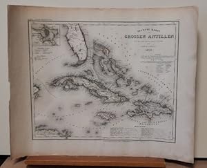
Neueste Karte der Grossen Antillen (Teilkolorierte Stahlstichkarte aus Meyers Grosser Stahlstich-Atlas)
Published by Hildburghausen, Amsterdam, Paris und Philadelphia, Verlag des Bibliographischen Instituts, 1850
Map
Condition: Gut. 46x36,5cm Gerollt, etwas anger�ndert, insges. gut. Sprache: Englisch, -------- Ansicht von Kuba, Jamaika und Haiti sowie einem Teil von Florida.
-

K�nigreich Hannover. Herzogthum Braunschweig und Lippe'sche L�nder. Grenzkolorierte Orig.-Stahlstichkarte mit kleinen Pl�nen von Hannover und Umgebung + G�ttingen und Umgebung. Gez. v. Major Radefeld, rev. v. L. Ravenstein.
Published by Hildburghausen, Bibliograph. Inst. 1861., 1861
Seller: Antiquariat Heiner Henke, Passau, Germany
Association Member: BOEV
Seller rating 5 out of 5 stars
37 x 33 cem. in 4 Segmenten auf Leinen aufgezogen. Gut erhalten.
-
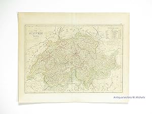
Die Schweiz 1852. Revidirt 1857.
Language: German
Published by Bibliograph. Institut, Hildburghausen, 1857
Seller: Magister Michalis, Internet-Antiquariat, Wielenbach, Germany
Seller rating 5 out of 5 stars
Map
Kein Einband. Condition: Sehr gut. Stahlstich, Blattgr��e ca. 29x23cm. Vierfarbig u. feinstens grenzkolorierte Karte (Original ohne sp�tere Nachzeichnungen). Mit statist. Notizen. +++ Steel engraving, original HAND COLORING in outline when published. +++ Aus Nichtraucherhaushalt. +++ Mehr Infos gerne �ber die Schaltfl�che 'Frage an den Anbieter'. +++ Rare.
-
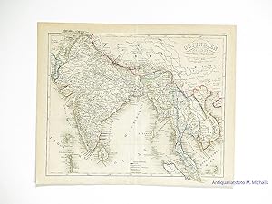
Ostindien 1855. Stahlstichkarte mit Grenzkolorit. Bergzeichnung v. Radefeld. Revidirt 1857.
Language: German
Published by Bibliograph. Institut, Hildburghausen, 1857
Seller: Magister Michalis, Internet-Antiquariat, Wielenbach, Germany
Seller rating 5 out of 5 stars
Map
Kein Einband. Condition: Sehr gut. Stahlstich, Blattgr��e ca. 29x23cm. Vierfarbig grenzkolorierte Karte (Original ohne sp�tere Nachzeichnungen). Zeigt das heutige Indien, Bangladesch und S�dostasien. +++ Steel engraving, original HAND COLORING in outline when published. +++ Aus Nichtraucherhaushalt. +++ Mehr Infos gerne �ber die Schaltfl�che 'Frage an den Anbieter'. +++ Rare.
-
Meyers Reiseb�cher - Wegweiser durch Th�ringen - (Originalausgabe 1890)
Published by Leipzig Wien, Bibliographisches Institut, 1890 (10. Aufl.), 1890
Seller: Libro-Colonia (Preise inkl. MwSt.), K�ln, NRW, Germany
Seller rating 5 out of 5 stars
X + 271 + 16 Seiten (durch Inhaltsverzeichnis erschlossen - siehe Abbildung 2-4), Original-Halbleineneinband ca. 10 � 15 cm, Einband st�rkere Gebrauchsspuren (siehe Abbildung 5), innen geringf�gige Gebrauchsspuren, insgesamt sch�nes und fest eingebundenes Exemplar ohne Stempel, Flecken, Anstreichungen etc.,
-
Spanien und Portugal. Revidirt 1856.
Language: German
Published by Bibliograph. Institut, Hildburghausen, 1856
Seller: Magister Michalis, Internet-Antiquariat, Wielenbach, Germany
Seller rating 5 out of 5 stars
Map
Kein Einband. Condition: Sehr gut. Stahlstich, Blattgr��e ca. 29x23cm. Vierfarbig u. feinstens grenzkolorierte Karte (Original ohne sp�tere Nachzeichnungen). Mit einem Nebenk�rtchen: Plan von Madrid. +++ Steel engraving, original HAND COLORING in outline when published. +++ Aus Nichtraucherhaushalt. +++ Mehr Infos gerne �ber die Schaltfl�che 'Frage an den Anbieter'. +++ Rare.
-

Das Adriameer mit seinen Uferstaaten 1858.
Language: German
Published by Bibliograph. Institut, Hildburghausen, 1856
Seller: Magister Michalis, Internet-Antiquariat, Wielenbach, Germany
Seller rating 5 out of 5 stars
Map
Kein Einband. Condition: Sehr gut. Stahlstich, Blattgr��e ca. 29x23cm. Vierfarbig grenzkolorierte Karte von Italien mit Gegenk�ste im S�den bis Otranto. Hell geblieben u. fast fleckenlos.+++ Steel engraving, original HAND COLORING in outline when published.+++ Aus Nichtraucherhaushalt. +++ Mehr Infos gerne �ber die Schaltfl�che 'Frage an den Anbieter'.