Railway Map (47 results)

Language: English
Published by Percival Marshall & Co, London
- Softcover
Seller: J J Basset Books, bassettbooks, bookfarm.co.uk, Peter Tavy, United KingdomJ J Basset Books, bassettbooks, bookfarm.co.uk
Contact seller4-star sellerCondition: Used
US$ 11.05
US$ 26.81 shippingShips from United Kingdom to U.S.A.Quantity: 1 available
Pictorial Card. Condition: Very Good Contents Near Fine. No Jacket. 7th Edition. Circa 1960's.Please Email for further details. Size: 8vo - over 7¾" - 9¾". Black & White Illustrations & Adverts + Fold Out Map (illustrator). Signed By an "H.L Williams".
Published by Published by Publicity Department Great Southern & Western Railway, Kingsbridge, Dublin, Dublin, Ireland 1910
- Softcover
- First Edition
Seller: WONDERFUL BOOKS BY MAIL, CHICO-CA, CA, U.S.A.WONDERFUL BOOKS BY MAIL
Contact seller5-star sellerCondition: Used - Good
US$ 25.00
US$ 3.75 shippingShips within U.S.A.Quantity: 1 available
Paperback. Condition: Good. Original Edition 1st ed.. GOOD CONDITION.Quite nice, bit rubs to spines, but otherwise clean, solid,bright text on GLOSSY PAPER STOCK.MANY NICE PHOTOS WITH VERY FEW AUTOMBILES. ; Black titles on orange stiff paper covers, square spine bound. ****THIS IS AN ORIGINAL PUB, NOT A REPRINT.**** ; 87pg thin…pages. Illustrated by Railroad MAP. Many glossy b&w photos (illustrator).
Language: English
Published by Canadian Pacific Railway 1901
- Softcover
Seller: Old Favorites Bookshop LTD (since 1954), Stouffville, ON, CanadaOld Favorites Bookshop LTD (since 1954)
Contact seller4-star sellerCondition: Used - Good
US$ 40.00
US$ 10.00 shippingShips from Canada to U.S.A.Quantity: 1 available
Paper Covers. Condition: Good to Very Good Condition. Dust Jacket Condition: No Dust Jacket. As Issued. Black / Dark Green paper covers the tied cord binding. Gilt embossed royal crest, with title on front cover. Covers lightly rubbed with corner crease at outside lower corner of back covert. last few pages show minor creases. T…his Souvenir booklet is in good to very good condition with minor wear. Photos availabler on request. Numerous b/w photos with fold out map at back of book. (illustrator).
Language: English
Published by Simpkin , Marshall , Hamilton , Kent & Co Ltd, London 1908
- Hardcover
Seller: R.D.HOOKER, Christchurch, United KingdomR.D.HOOKER
Contact seller5-star sellerCondition: Used - Very good
US$ 13.81
US$ 38.81 shippingShips from United Kingdom to U.S.A.Quantity: 1 available
Hardback. Condition: Very Good +. No Jacket. New Enlarged Edition an d best editon. 344 pp plus a supplementary chapter of 23 pp only in this edition. Plus publishers adverts. Title in gold on spine and front board with the crest of Canada. A book in remarkably good clean tight bright condition. Large Folding Coloured Map, Plus…Large Folding Map of the Canadian Pacific Railway with a Small Nick Plus Many Full Page Plates (illustrator).

- Softcover
- Print on Demand
Seller: Forgotten Books, London, United KingdomForgotten Books
Contact seller4-star sellerCondition: New
US$ 18.13
Free ShippingShips from United Kingdom to U.S.A.Quantity: Over 20 available
Paperback. Condition: New. Print on Demand. This book by the author and Medical Lake Remedies specialist presents practical knowledge to help readers understand the treatments available to them for sinus congestion and sinus pain. In addition to providing practical advice on identifying and managing sinus pain, the author presen…ts information on the roles of chronic inflammation and rhinitis in sinus discomfort, discussing the mechanisms and actions of the body's systems. This book provides practical knowledge for dealing with sinus issues, demystifying medical remedies, and offering advice on how to find relief from common conditions. This book is a reproduction of an important historical work, digitally reconstructed using state-of-the-art technology to preserve the original format. In rare cases, an imperfection in the original, such as a blemish or missing page, may be replicated in the book. print-on-demand item.
Language: English
Published by Doubleday, Page & Company, New York 1903
- Hardcover
- First Edition
Seller: Arroyo Seco Books, Pasadena, Member IOBA, Pasadena, CA, U.S.A.Arroyo Seco Books, Pasadena, Member IOBA
Contact seller4-star sellerCondition: Used - Very good
US$ 70.96
US$ 8.00 shippingShips within U.S.A.Quantity: 1 available
Hardcover. Condition: Very Good +. 1st Edition. X, 317 Pp. Red Cloth Stamped In Green And White. First Printing. No Marks, Remains Of Paper Label Over Publisher's Name At Bottom Of Spine. Light Wear, Cover Lettering Strong And Illustration Complete. Plates, Folding Railway Map, Illustrations In Text Throughout (illustrator).
Published by William Bryce, Toronto 1888
- Hardcover
Seller: Thomas J. Joyce And Company, Chicago, IL, U.S.A.Thomas J. Joyce And Company
Contact seller2-star sellerCondition: Used - Good
US$ 50.00
US$ 7.00 shippingShips within U.S.A.Quantity: 1 available
Hardcover. Condition: Good. Revised & Enlarged edition. Oblong 32mo, 57pp., grey-blue pictorial scenic cloth, needs to be recased. two short, closed tears in margin of the folding map. Issued as Bryce's Tourists' Illustrated Handbook to the Canadian Dominion. This work, dated December, 1888, reproduces Queen Victoria's commendat…ory note for Mr. Bryce done May 2, 1889. Excellent views across Canada, including the Falls of Niagara. 60 views on 57 litho plates. Folding map: "Map of the Dominion of Canada Showing Railway Connections from Atlantic To Pacific" (illustrator).
Language: English
Seller: K Books Ltd ABA ILAB, York, YORKS, United KingdomK Books Ltd ABA ILAB
Contact seller5-star sellerCondition: Used - Very good
US$ 27.62
US$ 26.14 shippingShips from United Kingdom to U.S.A.Quantity: 1 available
No Binding. Condition: Very Good. A splendid antique Railway Map. Excellent condition . Very detailed. Engraved Circa 1870. Finely coloured . Shows the portion of the Railway Route . South Coast Railway - detailed maps of the area round Brighton & Hastings.
Language: English
Seller: K Books Ltd ABA ILAB, York, YORKS, United KingdomK Books Ltd ABA ILAB
Contact seller5-star sellerCondition: Used - Very good
US$ 27.62
US$ 26.14 shippingShips from United Kingdom to U.S.A.Quantity: 1 available
No Binding. Condition: Very Good. A splendid original antique coloured map. . Excellent condition. A fine coloured early Railway Map - Great Western Railway - Oxford to Chester .circa 1831 - detailed.
Language: English
Seller: K Books Ltd ABA ILAB, York, YORKS, United KingdomK Books Ltd ABA ILAB
Contact seller5-star sellerCondition: Used - Very good
US$ 27.62
US$ 26.14 shippingShips from United Kingdom to U.S.A.Quantity: 1 available
No Binding. Condition: Very Good. A splendid antique Railway Map. Excellent condition . Very detailed. Engraved Circa 1870. Finely coloured . Shows the portion of the Railway Route . South Eastern Railway - detailed map - Dover and Hastings area.
Language: English
Seller: K Books Ltd ABA ILAB, York, YORKS, United KingdomK Books Ltd ABA ILAB
Contact seller5-star sellerCondition: Used - Very good
US$ 27.62
US$ 26.14 shippingShips from United Kingdom to U.S.A.Quantity: 1 available
No Binding. Condition: Very Good. A splendid antique Railway Map. Excellent condition . Very detailed. Engraved Circa 1870. Finely coloured . Shows the portion of the Railway Route . London to Birmingham.
Language: English
Seller: K Books Ltd ABA ILAB, York, YORKS, United KingdomK Books Ltd ABA ILAB
Contact seller5-star sellerCondition: Used - Very good
US$ 27.62
US$ 26.14 shippingShips from United Kingdom to U.S.A.Quantity: 1 available
No Binding. Condition: Very Good. A splendid antique Railway Map. Excellent condition . Very detailed. Engraved Circa 1870. Finely coloured . Shows the portion of the Railway Route . London to Brighton - detailed maps of the area round Reigate, Horsham and Uckfield etc.
GREAT NORTHERN RAILWAY, Sheet 1, London to Grantham & Nottingham - an Original Antique Map, 1860
GREAT NORTHERN RAILWAY, Sheet 1, London to Grantham & Nottingham - an Original Antique Map, 1860
Language: English
Published by Weekly Dispatch, London 1860
Seller: K Books Ltd ABA ILAB, York, YORKS, United KingdomK Books Ltd ABA ILAB
Contact seller5-star sellerCondition: Used - Very good
US$ 55.24
US$ 26.14 shippingShips from United Kingdom to U.S.A.Quantity: 1 available
No Binding. Condition: Very Good. An original antique map, mounted (matted) and ready to frame. No date of publication but c1860. The route of the Great Northern Railway is shown in 4 strips arranged side-by-side with counties coloured in outline. Other railway routes are shown as they join the Great Northern. Some fraying to co…rners, otherwise good. Edward WELLER (illustrator).

Language: English
Published by D. Appleton & Company 1866
- Hardcover
Seller: Arroyo Seco Books, Pasadena, Member IOBA, Pasadena, CA, U.S.A.Arroyo Seco Books, Pasadena, Member IOBA
Contact seller4-star sellerCondition: Used - Very good
US$ 237.50
US$ 8.00 shippingShips within U.S.A.Quantity: 1 available
Hardcover. Condition: Very Good. X, 843 Pp. Full Sheep, Morocco Spine Label, Gilt Edges, Marbled Endpapers And Matching Marbled Page-Block Edges. Wear But Spine Gilt Bright, Closed 2" Surface Crack At Lower Front Joint, Some Surface Peeling To Calf At Fore Edges. No Marks. Short Edge Tear To Railway Map Outside Of Printed Area.…Color Plates W/ Tissue Guards, Portriaits, Plates, Illustrations, Large Multi-Fold Railway Map, Many Other Maps (illustrator).
Chicago, Milwaukee & Puget Sound Railway / Chicago, Milwaukee & St. Paul Railway
Map. Chicago, Milwaukee & St. Paul Railway and Chicago, Milwaukee & Puget Sound Railway
Published by Poole Bros., Chicago 1910
- First Edition
Seller: Thomas J. Joyce And Company, Chicago, IL, U.S.A.Thomas J. Joyce And Company
Contact seller2-star sellerCondition: Used - Very good
US$ 65.00
US$ 7.00 shippingShips within U.S.A.Quantity: 1 available
Map. Condition: Very Good. First edition. Broadside, 4 folds, some loss to left border, otherwise fine. No copy on WorldCat. Map no. 4970. This map covers these railroads primarily in Washington State ( highlighted in yellow), with the surrounding states and provinces, into western Idaho. Measures approximately 48 x 64 cm.
Published by Washington 1856
- Hardcover
- First Edition
Seller: Thomas J. Joyce And Company, Chicago, IL, U.S.A.Thomas J. Joyce And Company
Contact seller2-star sellerCondition: Used - Fair
US$ 100.00
US$ 7.00 shippingShips within U.S.A.Quantity: 1 available
Hardcover. Condition: Fair. First & Quarto edition. 4to, orig. full sheep, lacks t-p. Ex libris House of Repr. Vol. #794. House Exec. Doc. no. 91. [Howes P3; Wheat, TRANSMISSISSIPPI, 822ff; Wagner - Camp - Becker 263a; Rittenhouse 442]. "Report on the Botany of the [Whipple] Expedition", & "Report on the Zoology of the Expeditio…n." "This widely known work requires no comment - Cowan, CALIFORNIA, p.512." Lithographs, folding map. lithographs, folding map (illustrator).
 More images
Stadtplan, Bahn- und U-Bahn-Plan London um 1910: Railway Map of London and its environs
Stadtplan, Bahn- und U-Bahn-Plan London um 1910: Railway Map of London and its environs
Published by London, W.H. Smith & Son um 1910 1910
- Hardcover
- Map
Seller: Antiquariat Thomas Mertens, Berlin, GermanyAntiquariat Thomas Mertens
Contact seller4-star sellerCondition: Used - Very good
US$ 83.44
US$ 63.65 shippingShips from Germany to U.S.A.Quantity: 1 available
Hardcover. Condition: Gut. Stadtplan, Bahn- und U-Bahn-Plan London um 1910: Railway Map of London and its environs Karte London Underground --- "W.H. Smith & Sons Railway Map of London and its environs." Auf Leinen aufgezogen; der Leinen-Einband lose beiliegend. London, W.H. Smith & Son um 1910 Teilkolorierte lithographierte Kar…te im Format 40,5 x 55 cm (zusammengefaltet 13,5 x 8,5 cm; der lose beiliegender Leineneinband 14,5 x 10 cm). --- Zustand: Etwas fleckig; rückseitig ein Segment mit Kleberesten durch die Lösung vom Einband.
Published by London. G.F. Cruchley, Map-Seller & Globe Maker. N.d. c.[1850]'s 1850
- Softcover
Seller: J. Patrick McGahern Books Inc. (ABAC), Ottawa, ON, CanadaJ. Patrick McGahern Books Inc. (ABAC)
Contact seller4-star sellerCondition: Used - Very good
US$ 184.10
US$ 10.00 shippingShips from Canada to U.S.A.Quantity: 1 available
Soft cover. Condition: Very Good. Large folding coloured map 56x 50cm (22" x 20"), folded to 12mo,(18cm), in printed wraps with titles on the upper cover in frame border, slight wear to creases & wrapper edges else very good to fine, rare (n12).
 More images
Published by Unpublished Original 1859
- Hardcover
- Map
Seller: HALEWOOD AND SONS ABA ILAB Est. 1867., PRESTON, , United KingdomHALEWOOD AND SONS ABA ILAB Est. 1867.
Contact seller2-star sellerCondition: Used - Very good
US$ 269.27
US$ 16.22 shippingShips from United Kingdom to U.S.A.Quantity: 1 available
Hardcover. Condition: Very Good. Unique and most attractive linen-mounted folding outline-coloured map. Extending to 32" x 35". Original marbled boards with hand-written label (a little rubbed) Initialled "BGa" to linen backing.
 More images
Published by London: G. F. Crutchley 1869
- Hardcover
- Map
Seller: Forest Books, ABA-ILAB, Grantham, LINCS, United KingdomForest Books, ABA-ILAB
Contact seller4-star sellerCondition: Used
US$ 255.46
US$ 33.52 shippingShips from United Kingdom to U.S.A.Quantity: 1 available
Coloured map on linen, (590 x 505 mm), divided into 28 sections and laid on linen, scale approximately 8 miles to the inch, a couple of minor marks but overall in good condition, orig. blue pebbled-patterned cloth, lettered in gilt on upper cover (Crutchley's Tourist Map of Yorkshire with the Railways), advert leaf pasted onto i…nside front cover. The Harold Whitaker Collection, 321.
 More images
Published by A. and C. Black. No date but c.1875 1875
Seller: Marrins Bookshop, Folkestone, KENT, United KingdomMarrins Bookshop
Contact seller4-star sellerCondition: Used
US$ 138.09
US$ 33.99 shippingShips from United Kingdom to U.S.A.Quantity: 1 available
Folding hand-coloured map 25 x 33 inches approx., of the whole of Scotland, showing the roads and railways. Bound in the original green cloth with blind-stamped decoration and gilt title within decorative gilt cartouche and price 4s.6d. Ownership inscription and date, August 1881, in ink to paste down; also a neat list, with dat…es in 1881, of 13 journeys made by the owner, each of which is neatly drawn on the map in red ink. PRINTS/MAPS SCOTLAND MAPS TRANSPORT SCOTTISH NON-FICTION PRINTS/MAPS.
Published by (Circa1972). 1972
Seller: Asia Bookroom ANZAAB/ILAB, Canberra, ACT, AustraliaAsia Bookroom ANZAAB/ILAB
Contact seller5-star sellerCondition: Used
US$ 181.39
US$ 21.25 shippingShips from Australia to U.S.A.Quantity: 1 available
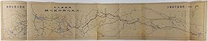
Long colour folding railway map, scale 1: 600,000, a smaller map titled "Geographic Location Map" at the left hand end of the sheet showing the two terminuses - the Shahe station and Tongliao Station. The legend shows roads, rivers, provincial boundaries, tunnels, bridges, adopted plans, comparative lines, current railway lines,… connection lines and the Great Wall. A quote from Chairman Mao's ????, ???? [To design and build with great care] is highlighted. Text in Chinese, measures 27 x 135cm. Some neat annotations, a little browning, a few neatly repaired tears along folds. Good copy. Shahe-Tongliao Railway, also known as Shatong Railway, now known as Beijing-Tonghe Railway, was built between 1972-1977 and was in operation in 1980.
 More images
Published by New England Railway Publishing Company, Boston 1902
- Map
Seller: Babylon Revisited Rare Books, Northampton, MA, U.S.A.Babylon Revisited Rare Books
Contact seller4-star seller28.75 x 43.5 in (73.025 x 110.49 cm). Includes insets of Alaska, Yellowstone National Park, the Philippine Islands, and the Hawaiian Islands. Nearly Very Good, some small split and tears.

- Hardcover
- Map
Seller: Geographicus Rare Antique Maps, Brooklyn, NY, U.S.A.Geographicus Rare Antique Maps
Contact seller4-star sellerHardcover. Very good. Closed margin tears professionally repaired on verso. Light dampstaining in bottom left corner not effecting printed image. Size 30.25 x 116.5 Inches. Measuring just short of ten feet, this is an impressive 1929 Omaha, Lincoln and Beatrice Railway cyanotype or blueprint map of part of Lincoln, Nebraska, inc…luding all of the modern-day City Campus of the University of Nebraska-Lincoln. A Closer Look The University of Nebraska appears near the left edge of the printed image, with 'State University' and 'University Addition' marking where the university had been and illustrating how it had grown. Both Memorial Stadium and the Nebraska Coliseum are illustrated and labeled, underscoring the importance of Nebraska Athletics. Both had been built only a few years before this map was printed. Curiously, no other buildings on campus are labeled, but businesses throughout the city are identified. Below the title, a notation advises the viewer that the present edition is 'Correct to June 12, 1947'. The Railroads While this map was made by the Omaha, Lincoln and Beatrice Railway and traces its tracks through the city, four other railways are illustrated as well. These are the Chicago, Burlington and Quincy Railroad; the Chicago and North Western Railroad; the Chicago, Rock Island, and Pacific Railroad; and the Missouri Pacific Railroad. Notations differentiate between the railroads. The Omaha, Lincoln and Beatrice Railway Founded in 1903, the Omaha, Lincoln and Beatrice Railway was created in an attempt to create passenger rail service between the three cities. The rails never extended outside of Lincoln, however it still operates as a private company to this day as a Class III switching railroad. Cyanotype: Why so Blue? Cyanotype is a photo-reprographic technique developed in 1842 by the British astronomer John Herschel (1792 - 1871). Sometimes called a 'sunprint', the technique employs a solution of ferric ammonium citrate and potassium ferricyanide , which painted on white paper or cloth, reacts when exposed to sunlight to dye the object a brilliant blue. Areas blocked from ultraviolet exposure remain undyed and white. Herschel developed the technique to reproduce his astronomical notes, but others quickly realized that any object capable of blocking light could be used to create a cyanotype image quickly and easily. By the late 19th century, the process became popular with designers, military, architects, and engineers (blueprints), who used the cheap and effective technique to quickly and exactly reproduce images in the field. Cyanotyping is limited in that only a single copy can be made at one time, so it was only practical for short-term field work. It is also of note that cyanotypes remain extremely reactive to light and, over time, fade or degrade, making them extremely ephemeral. The process fell out of fashion in most places by the 1920s but remains in use in some parts of the world, such as India and Nepal, to this day. Publication History and Census This map was created and published by the Omaha, Lincoln, and Beatrice Railway, on June 10, 1929, with corrections to June 12, 1947. This is the only known cataloged example of either edition of the map.

Mombasa - Victoria Lake Railway.
1893 Royal Geographical Society Map of the Mombasa-Lake Victoria Railway
- Softcover
- Map
Seller: Geographicus Rare Antique Maps, Brooklyn, NY, U.S.A.Geographicus Rare Antique Maps
Contact seller4-star sellerSoft cover. Very good. Light wear and toning along original fold lines. Closed margin tear professionally repaired on verso. Size 24.5 x 33.75 Inches. This is an 1893 Royal Geographical Society map of the Mombasa-Lake Victoria Railway in modern-day Kenya. The map details the early planning and construction stages of one of the w…orlds more infamous and loved heritage railroads, the famed 'Lunatic Line'. Parts of the railroad still run. Historical Context This map presents the survey work conducted by a team of five men, four of which were royal engineers, between Mombasa on the Indian Ocean and Kisumu on the shores of Lake Victoria. Both the projected and surveyed routes are illustrated here, with solid black lines marking projected routes and dotted lines following surveyed routes. Stations are marked along the projected lines, while the camps used by the surveyors are identified along their route. Rivers, lakes, and other topographical features are noted and numerous printed notations comment on the vegetation, terrain, and indigenous inhabitants. The Uganda Railway Construction began on the Uganda Railway, the only strategic railway constructed in tropical Africa at the time, in 1896. Built during the 'scramble for Africa', the railroad began operation in 1901, after suffering significant human losses due to disease, tribal resistance, and hostile wildlife, including the infamous man-eating Tsavo lions. All these factors, plus the exorbitant cost, earned the railroad the nickname Lunatic Line . Other than the obvious commercial impact, the Uganda Railroad also became an inseparable part of safari expeditions around the turn of the 20th century. Even former U.S. President Theodore Roosevelt rode on the train, reportedly spending most of his time riding on the platform attached to the front of the locomotive. 'Scramble for Africa' The 'scramble for Africa' officially began with the 1884-85 Berlin Conference. The Berlin Conference was a meeting of colonial powers in Berlin during the New Imperialism Period. The resultant 'General Act of the Berlin Conference' is considered to be the formalization of the 'Scramble for Africa', wherein much of Africa was partitioned between major European powers (with little regard to the claims and priorities of the indigenous peoples). To claim territory, the delegates needed to prove 'effective occupation.' This means they needed to establish the existence of treaties with local powers, show that their flags were being flown (hence the identification of various flags on this map), or have active forts in the region. The conference marked a major change in the European approach to Africa. Initially European powers treated African peoples much like Native Americans, establishing trading relationships and alliances with indigenous kingdoms. After the Berlin Conference, heightened colonial activity and the need to prove effective occupation lead to the subjugation of most indigenous control. Publication History and Census This map was created and published by the Royal Geographical Society for publication in the August 1893 edition of The Geographical Journal from a map issued by the Intelligence Division of the War Office. Two examples are catalogued in the OCLC as being part of the collections at the University of Chicago and the University of Oxford. References: OCLC 53894348.

Mark! When you want a Pointer regarding your western trip
1906 Northern Pacific Railway 'Pointer' Dog Map of the Western United States
- Softcover
- Map
Seller: Geographicus Rare Antique Maps, Brooklyn, NY, U.S.A.Geographicus Rare Antique Maps
Contact seller4-star sellerSoft cover. Fair. Area of infill along borrom border effecting printed ara in California. Closed tear extending one inch into printed area from bottom margin professionally repaired on verso. Closed margin tears professionally repaired on verso. List of General and District Passenger Agents printed on verso. Size 5.5 x 8.5 Inche…s. An utterly charming 1896 lithograph pictorial map issued to promote travel to the Pacific Northwest via the Northern Pacific Railway. This map was issued in 1896 by Charles S. Fee, general passenger agent for the Northern Pacific Railway. It covers the western part of the United States roughly from the Great Lakes to the Pacific. Superimposed upon the map is the image of an English Pointer dog in classic 'pointer' pose. The dog's head, spine, and tail illustrate the course of the Northern Pacific Railway from Duluth, Minnesota to Olympia, Washington. Promotional copy overlaying the map reads, Mark! When you want a Pointer regarding your western trip call on your nearest ticket agent or district passenger agent on the Northern Pacific Railway Co. or address Chas. S. Fee General Passenger Agent St. Paul, Minn. A list of passenger agents is printed on the verso. Publication History and Census This map was engraved and printed for the Northern Pacific by Poole Brothers of Chicago. It is quite rare, with only a single 'digital' example listed at the OCLC and one at the Washington State Historical Society. This map was printed in several different formats. We have encountered it printed on stationary and, as here, in the form of a print magazine advertisement. References: OCLC 611611768. Washington State Historical Society, EPH 385.061/ N814m 1896.
44th Year of Issue. Official Guide: Royal Automobile Club of Victoria, Government Tourist Bureau,
BROADBENT'S OFFICIAL ROAD AND RAILWAY MAP OF VICTORIA: EASTERN SECTION.
Seller: Berkelouw Rare Books, Berrima, NSW, AustraliaBerkelouw Rare Books
Contact seller4-star sellerCondition: Used
US$ 79.81
US$ 38.00 shippingShips from Australia to U.S.A.Quantity: 1 available
Melbourne (1944). 8vo. Orig. illust wrapper. (112pp.). With large fold. map, text-maps, and contemp. adverts. Slight damage/tear to p.84, otherwise fine and complete.

- Map
Seller: Geographicus Rare Antique Maps, Brooklyn, NY, U.S.A.Geographicus Rare Antique Maps
Contact seller4-star sellerVery good. Minor wear along fold lines. Size 8.5 x 7.5 Inches. This is a scarce 1924 railway map of the Sichuan and Yunnan Provinces of China issued by the Imperial Japanese Government Railways. It covers from Hanoi north to Han-Chung and from Nanning east as far as India and Tibet. The map is highly detailed and notes various c…ities, rivers, boundaries, towns, mountains and other topography. Railway lines are also noted. This map was issued as part of the 1924 Official Series Vol. D of the Guide to China and printed at the Toppan Printing Company.

- Map
Seller: New World Cartographic, Chicago, IL, U.S.A.New World Cartographic
Contact seller4-star sellerBy: Anglo American CompanyDate: 1890 (circa)Dimensions: 15.6 x 16.5 inches (39.6 x 42 cm)This scarce map depicts the privately owned railway line from Hobart to Launceston. The Tasmanian Main Line Company (T.M.L.) was a privately owned railway company which operated in Tasmania from 1872 to 1890. The company provided the first r…ail services between Hobart and Launceston, where it connected with the Launceston and Western Railway. On 1 October 1890, the Tasmanian Government bought the Tasmanian Main Line Company. The railway played an important role in the economic development of the island state.The map is highly detailed topographically. Settlements, towns and counties are named and geographical features such as the mountainous region of the Central Highlands area, which covers most of the central western parts of the state are shown in detail. The Midlands in the central east, is fairly flat, and is predominantly used for agriculture, although farming activity is scattered throughout other regions of the state.Condition: This folding lithograph map in A condition is colored, with very light foxing in the lower center in the border and edge.Inventory #117301200 W. 35th Street #425 Chicago, IL 60609 | P: (312) 496 - 3622.

- Map
Seller: Geographicus Rare Antique Maps, Brooklyn, NY, U.S.A.Geographicus Rare Antique Maps
Contact seller4-star sellerVery good. Minor wear along fold lines. Size 11 x 9.5 Inches. This is a beautiful 1924 map of Qingdao or Tsingtao or Chingtao, located in the eastern Shandong Province of China, issued by the Imperial Japanese Government Railways. The map depicts the city, an important sea port and naval base and China's most livable city in gre…at detail, noting streets, individual buildings, rivers, railways, and other topography. The great harbor is noted. The map also notes railway lines. An index in the top left quadrant notes the locations marked on the map. This map was issued as part of the 1924 Official Series Vol. D of the Guide to China and printed at the Toppan Printing Company.


